Lewis Place, St. Louis
Neighborhood of St. Louis in Missouri, United States
Lewis Place | |
|---|---|
Neighborhood of St. Louis | |
 | |
 Location (red) of Lewis Place within St. Louis | |
| Country | United States |
| State | Missouri |
| City | St. Louis |
| Wards | 4, 18 |
| Area | |
| • Total | 0.33 sq mi (0.9 km2) |
| Population (2020)[1] | |
| • Total | 1,359 |
| • Density | 4,100/sq mi (1,600/km2) |
| ZIP code(s) | Parts of 63108, 63113 |
| Area code(s) | 314 |
| Website | stlouis-mo.gov |
Lewis Place is a neighborhood of St. Louis, Missouri. Lewis Place is defined by Martin Luther King Drive on the North, Delmar Boulevard on the South, Newstead Avenue on the East, and Walton on the West.
History
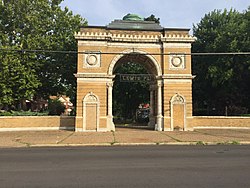
Lewis Place was laid out in 1890 and was privately owned and developed by the family of William J. Lewis. The Lewis Place historic design recognizes the architectural significance of housing around the turn of the century. The architectural firm of Barnett, Haynes & Barnett has been admired by historic preservationists throughout the country.[2]
Lewis Place is a three-block street with the center parkway which is lined on both sides with beautiful homes built between 1890 and 1928. The housing stock reflects the ambiance of housing along the beautiful Euclid-Central West End area.
Lewis Place Historic District was placed on the National Register of Historic Places on September 15, 1980.[3] Lewis Place is situated in the midst of a revitalizing community with St. Louis University, Washington University and Ranken Technical College all within a three-mile radius of the Lewis Place community.
Demographics
In 2020 Lewis Place's racial makeup was 84.5% Black, 11.8% White, 0.4% Native American, 0.2% Asian, 2.1% Two or More Races, and 1.0% Some Other Race. 1.8% of the population was of Hispanic or Latino origin.[4]
| Year | Pop. | ±% |
|---|---|---|
| 1990 | 2,696 | — |
| 2000 | 2,004 | −25.7% |
| 2010 | 1,673 | −16.5% |
| 2020 | 1,359 | −18.8% |
References
- v
- t
- e
Neighborhoods of St. Louis
- Academy
- Baden
- Benton Park
- Benton Park West
- Bevo Mill
- Botanical Heights
- Boulevard Heights
- Carondelet
- Carr Square
- Central West End
- Cheltenham
- Chinatown (defunct since 1966)
- Clayton/Tamm
- Clifton Heights
- College Hill
- Columbus Square
- Compton Heights
- Covenant Blu Grand Center
- DeBaliviere Place
- "Dogtown"
- Downtown
- Downtown West
- Dutchtown
- Ellendale
- Fairground
- Forest Park Southeast
- Fountain Park
- Fox Park
- Franz Park
- Gate District
- Gravois Park
- Greater Ville
- Hamilton Heights
- The Hill
- Hi-Pointe
- Holly Hills
- Hyde Park
- JeffVanderLou
- Kings Oak
- Kingsway East
- Kingsway West
- Kosciusko
- Lafayette Square
- LaSalle Park
- Lewis Place
- Lindenwood Park
- Marine Villa
- Mark Twain
- Mark Twain/I-70 Industrial
- McKinley Heights
- Midtown
- Mill Creek Valley (defunct since 1960s)
- Mount Pleasant
- Near North Riverfront
- Northampton
- North Point
- North Riverfront
- O'Fallon
- Old North St. Louis
- Patch
- Peabody–Darst–Webbe
- Penrose
- Princeton Heights
- Riverview
- Shaw
- Skinker DeBaliviere
- Soulard
- Southampton
- Southwest Garden
- St. Louis Hills
- St. Louis Place
- Tiffany
- Tower Grove East
- Tower Grove South
- Vandeventer
- The Ville
- Visitation Park
- Walnut Park East
- Walnut Park West
- Wells/Goodfellow
- West End
- Wydown/Skinker
38°39′15″N 90°15′07″W / 38.6542°N 90.2520°W / 38.6542; -90.2520
 | This St. Louis location article is a stub. You can help Wikipedia by expanding it. |
- v
- t
- e


 Lewis_Place,_St._Louis