List of Category A listed buildings in Aberdeenshire

Map all coordinates using OpenStreetMap
Download coordinates as:
- KML
- GPX (all coordinates)
- GPX (primary coordinates)
- GPX (secondary coordinates)
This is a list of Category A listed buildings in Aberdeenshire, north-east Scotland.
In Scotland, the term listed building refers to a building or other structure officially designated as being of "special architectural or historic interest".[1] Category A structures are those considered to be "buildings of national or international importance, either architectural or historic, or fine little-altered examples of some particular period, style or building type."[2] Listing was begun by a provision in the Town and Country Planning (Scotland) Act 1947, and the current legislative basis for listing is the Planning (Listed Buildings and Conservation Areas) (Scotland) Act 1997.[3] The authority for listing rests with Historic Scotland, an executive agency of the Scottish Government, which inherited this role from the Scottish Development Department in 1991. Once listed, severe restrictions are imposed on the modifications allowed to a building's structure or its fittings. Listed building consent must be obtained from local authorities prior to any alteration to such a structure.[3] There are approximately 47,400 listed buildings in Scotland, of which around 8% (some 3,800) are Category A.[4]
The council area of Aberdeenshire covers 6,313 square kilometres (2,437 sq mi), and has a population of around 245,800. There are 195 Category A listed buildings in the area.
Listed buildings
| Name | Location | Date Listed | Grid Ref. [note 1] | Geo-coordinates | Notes | LB Number [note 2] | Image |
|---|---|---|---|---|---|---|---|
| Arbuthnott House, North Bridge over Arbuthnott Burn | Arbuthnott | NO7950475146 | 56°52′02″N 2°20′16″W / 56.867266°N 2.337811°W / 56.867266; -2.337811 (Arbuthnott House, North Bridge over Arbuthnott Burn) | [5] | 31 |  Upload another image | |
| Braemar Castle | Braemar | NO1560492374 | 57°00′53″N 3°23′29″W / 57.014753°N 3.391476°W / 57.014753; -3.391476 (Braemar Castle) | [6] | 36 |  Upload another image | |
| Tilquhillie Castle | Banchory | NO7217694143 | 57°02′15″N 2°27′36″W / 57.037533°N 2.460104°W / 57.037533; -2.460104 (Tilquhillie Castle) | [7] | 38 | 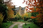 Upload another image | |
| Park Bridge over River Dee | Drumoak | NO7965398179 | 57°04′27″N 2°20′14″W / 57.074181°N 2.337232°W / 57.074181; -2.337232 (Park Bridge over River Dee) | [8] | 45 | 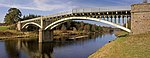 Upload another image | |
| Old Parish Church of Auchindoir | Auchindoir, Lumsden | NJ4776624559 | 57°18′31″N 2°52′07″W / 57.308604°N 2.86867°W / 57.308604; -2.86867 (Old Parish Church of Auchindoir) | [9] | 2732 |  Upload another image | |
| Craig Castle | Auchindoir, Lumsden | NJ4706824826 | 57°18′39″N 2°52′49″W / 57.310922°N 2.880312°W / 57.310922; -2.880312 (Craig Castle) | [10] | 2736 |  Upload Photo | |
| Druminnor Castle | Rhynie | NJ5131526403 | 57°19′32″N 2°48′36″W / 57.32556°N 2.810132°W / 57.32556; -2.810132 (Druminnor Castle) | [11] | 2743 | Upload Photo | |
| Aberdour House | New Aberdour | NJ9098163935 | 57°39′55″N 2°09′10″W / 57.665208°N 2.152832°W / 57.665208; -2.152832 (Aberdour House) | [12] | 2768 | Upload Photo | |
| Orrok (or Orrock) House | Balmedie | 16 April 1971 | NJ9640119560 | 57°16′00″N 2°03′41″W / 57.266685°N 2.061312°W / 57.266685; -2.061312 (Orrok (or Orrock) House) | [13] | 2778 |  Upload another image |
| Mounie Castle, original block | Daviot | NJ7666828671 | 57°20′53″N 2°23′22″W / 57.347939°N 2.38934°W / 57.347939; -2.38934 (Mounie Castle, original block) | [14] | 2793 | 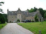 Upload another image | |
| Benholm Castle | Benholm, Gourdon | NO8040570430 | 56°49′30″N 2°19′22″W / 56.82494°N 2.322667°W / 56.82494; -2.322667 (Benholm Castle) | [15] | 2807 | Upload Photo | |
| Benholm Parish Church | Kirktown of Benholm, Gourdon | NO8043869251 | 56°48′52″N 2°19′19″W / 56.81435°N 2.322035°W / 56.81435; -2.322035 (Benholm Parish Church) | [16] | 2813 | 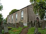 Upload another image | |
| Bourtie Parish Church | Bourtie, Oldmeldrum | 16 April 1971 | NJ8045524860 | 57°18′50″N 2°19′34″W / 57.313885°N 2.326112°W / 57.313885; -2.326112 (Bourtie Parish Church) | [17] | 2815 |  Upload another image |
| Bourtie House | Bourtie, Oldmeldrum | 16 April 1971 | NJ7854424047 | 57°18′23″N 2°21′28″W / 57.306496°N 2.357764°W / 57.306496; -2.357764 (Bourtie House) | [18] | 2819 | 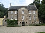 Upload another image |
| Barra Castle | Bourtie, Oldmeldrum | 16 April 1971 | NJ7922325756 | 57°19′19″N 2°20′48″W / 57.321879°N 2.346639°W / 57.321879; -2.346639 (Barra Castle) | [19] | 2821 |  Upload another image |
| Pitcaple Castle | Pitcaple, Garioch | NJ7273026084 | 57°19′28″N 2°27′16″W / 57.324482°N 2.454486°W / 57.324482; -2.454486 (Pitcaple Castle) | [20] | 2830 | Upload Photo | |
| Chapel of Garioch, Churchyard Gateway (Pittodrie's Yate) | Garioch | NJ7159124141 | 57°18′25″N 2°28′23″W / 57.306959°N 2.473175°W / 57.306959; -2.473175 (Chapel of Garioch, Churchyard Gateway (Pittodrie's Yate)) | [21] | 2846 |  Upload another image | |
| Arbuthnott Parish Kirk | Arbuthnott | NO8015574645 | 56°51′46″N 2°19′38″W / 56.862794°N 2.327093°W / 56.862794; -2.327093 (Arbuthnott Parish Kirk) | [22] | 2876 | 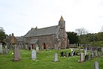 Upload another image | |
| Allardyce Castle | Inverbervie | NO8173673947 | 56°51′24″N 2°18′04″W / 56.856589°N 2.301114°W / 56.856589; -2.301114 (Allardyce Castle) | [23] | 2878 | 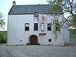 Upload another image | |
| Allardyce Castle - Gate Piers | Inverbervie | NO8172973932 | 56°51′23″N 2°18′04″W / 56.856454°N 2.301228°W / 56.856454; -2.301228 (Allardyce Castle - Gate Piers) | [24] | 2879 | Upload Photo | |
| Arbuthnott House | Arbuthnott | NO7949875071 | 56°52′00″N 2°20′16″W / 56.866592°N 2.337903°W / 56.866592; -2.337903 (Arbuthnott House) | [25] | 2880 |  Upload another image | |
| Bridge of Alvah | Over River Deveron, Banff | NJ6802061067 | 57°38′18″N 2°32′14″W / 57.638397°N 2.537292°W / 57.638397; -2.537292 (Bridge of Alvah) | [26] | 2883 |  Upload another image | |
| Fishing Temple, Duff House | Banff | NJ6906562848 | 57°39′16″N 2°31′12″W / 57.654467°N 2.520019°W / 57.654467; -2.520019 (Fishing Temple, Duff House) | [27] | 2885 |  Upload another image | |
| Dunlugas House | Turriff | NJ6956055491 | 57°35′18″N 2°30′39″W / 57.588421°N 2.510796°W / 57.588421; -2.510796 (Dunlugas House) | [28] | 2888 | 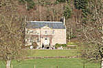 Upload another image | |
| Dunnottar Castle - Keep | Stonehaven | NO8804783857 | 56°56′45″N 2°11′53″W / 56.94582°N 2.198098°W / 56.94582; -2.198098 (Dunnottar Castle - Keep) | [29] | 2898 | 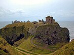 Upload another image | |
| Dunnottar Castle - Entrance Gateway and Guardrooms | Stonehaven | NO8803883883 | 56°56′46″N 2°11′54″W / 56.946054°N 2.198247°W / 56.946054; -2.198247 (Dunnottar Castle - Entrance Gateway and Guardrooms) | [30] | 2919 |  Upload another image | |
| Dunnottar Castle - Benholm's Lodgings | Stonehaven | NO8802883884 | 56°56′46″N 2°11′54″W / 56.946062°N 2.198412°W / 56.946062; -2.198412 (Dunnottar Castle - Benholm's Lodgings) | [31] | 2920 | Upload another image | |
| Castle Fraser | Kemnay | NJ7227612557 | 57°12′11″N 2°27′38″W / 57.202948°N 2.460506°W / 57.202948; -2.460506 (Castle Fraser) | [32] | 2924 |  Upload another image | |
| Castle Fraser, stable block | Kemnay | NJ7202912446 | 57°12′07″N 2°27′52″W / 57.201935°N 2.464581°W / 57.201935; -2.464581 (Castle Fraser, stable block) | [33] | 2925 |  Upload another image | |
| Castle Fraser, sundial | Kemnay | NJ7233212581 | 57°12′11″N 2°27′34″W / 57.203167°N 2.459582°W / 57.203167; -2.459582 (Castle Fraser, sundial) | [34] | 2927 | Upload Photo | |
| Fraser Mausoleum, Old Churchyard of Cluny | Sauchen | NJ6848112571 | 57°12′10″N 2°31′24″W / 57.202827°N 2.523317°W / 57.202827; -2.523317 (Fraser Mausoleum, Old Churchyard of Cluny) | [35] | 2947 |  Upload another image | |
| Old Churchyard of Cluny | Sauchen | NJ6847212563 | 57°12′10″N 2°31′24″W / 57.202755°N 2.523465°W / 57.202755; -2.523465 (Old Churchyard of Cluny) | [36] | 2948 |  Upload another image | |
| Cluny Castle | Sauchen | NJ6890012743 | 57°12′16″N 2°30′59″W / 57.204401°N 2.516404°W / 57.204401; -2.516404 (Cluny Castle) | [37] | 2949 |  Upload another image | |
| Tillycairn Castle | Sauchen | NJ6648311426 | 57°11′33″N 2°33′22″W / 57.1924°N 2.55623°W / 57.1924; -2.55623 (Tillycairn Castle) | [38] | 2959 | Upload Photo | |
| Culsalmond Old Parish Church | Kirkton of Culsalmond, Huntly | NJ6500732941 | 57°23′08″N 2°35′01″W / 57.385544°N 2.583704°W / 57.385544; -2.583704 (Culsalmond Old Parish Church) | [39] | 2960 | 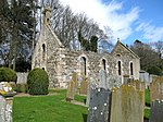 Upload another image | |
| Crathie Suspension Bridge over River Dee | Crathie | NO2659994252 | 57°02′01″N 3°12′40″W / 57.033501°N 3.211007°W / 57.033501; -3.211007 (Crathie Suspension Bridge over River Dee) | [40] | 2988 |  Upload another image | |
| Crathie Girder Bridge over River Dee | Crathie | NO2621094923 | 57°02′22″N 3°13′03″W / 57.039465°N 3.217611°W / 57.039465; -3.217611 (Crathie Girder Bridge over River Dee) | [41] | 2989 |  Upload another image | |
| Abergeldie Castle | Deeside | NO2870995281 | 57°02′35″N 3°10′36″W / 57.043074°N 3.176542°W / 57.043074; -3.176542 (Abergeldie Castle) | [42] | 3005 |  Upload another image | |
| Old Invercauld Bridge (Bridge of Dee) | Braemar | NO1862990942 | 57°00′09″N 3°20′28″W / 57.002436°N 3.341213°W / 57.002436; -3.341213 (Old Invercauld Bridge (Bridge of Dee)) | [43] | 3010 |  Upload another image | |
| Auchanachie Castle | Ruthven | NJ4985746917 | 57°30′35″N 2°50′19″W / 57.509651°N 2.838544°W / 57.509651; -2.838544 (Auchanachie Castle) | [44] | 3016 | Upload Photo | |
| Parish Church of Crimond | Crimond | 16 April 1971 | NK0538956766 | 57°36′03″N 1°54′41″W / 57.600876°N 1.911493°W / 57.600876; -1.911493 (Parish Church of Crimond) | [45] | 3028 |  Upload another image |
| Haddo House, Mains of Haddo | Tarves | NK0775057166 | 57°24′11″N 2°13′16″W / 57.403°N 2.221°W / 57.403; -2.221 (Haddo House, Mains of Haddo) | [46] | 3034 |  Upload another image | |
| Finzean Sawmill and Turning Mill | Finzean | NO5911991586 | 57°00′49″N 2°40′29″W / 57.013589°N 2.674822°W / 57.013589; -2.674822 (Finzean Sawmill and Turning Mill) | [47] | 3046 |  Upload another image | |
| Inchdrewer Castle | Banff | NJ6559860714 | 57°38′06″N 2°34′40″W / 57.635048°N 2.577805°W / 57.635048; -2.577805 (Inchdrewer Castle) | [48] | 3049 | 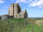 Upload another image | |
| Potarch Bridge over River Dee | Potarch, Kincardine O'Neil | NO6075997312 | 57°03′55″N 2°38′55″W / 57.065166°N 2.648714°W / 57.065166; -2.648714 (Potarch Bridge over River Dee) | [49] | 3095 |  Upload another image | |
| Finzean Bucket Mill | Finzean | NO5776091208 | 57°00′36″N 2°41′50″W / 57.010071°N 2.697136°W / 57.010071; -2.697136 (Finzean Bucket Mill) | [50] | 3100 |  Upload another image | |
| Park House | Drumoak | NO7800497548 | 57°04′06″N 2°21′52″W / 57.068436°N 2.364375°W / 57.068436; -2.364375 (Park House) | [51] | 3103 |  Upload another image | |
| Drum Castle | Drumoak | NJ7962000494 | 57°05′42″N 2°20′17″W / 57.094975°N 2.337966°W / 57.094975; -2.337966 (Drum Castle) | [52] | 3113 |  Upload another image | |
| Rhu-Na-Haven | Aboyne, Rhu-Na-Haven Road | NO5141597740 | 57°04′05″N 2°48′10″W / 57.068118°N 2.802864°W / 57.068118; -2.802864 (Rhu-Na-Haven) | [53] | 3126 |  Upload another image | |
| Dunecht House | Dunecht | NJ7508307846 | 57°09′39″N 2°24′49″W / 57.160792°N 2.413574°W / 57.160792; -2.413574 (Dunecht House) | [54] | 3133 |  Upload another image | |
| Echt Parish Church | Echt | NJ7391105667 | 57°08′28″N 2°25′58″W / 57.141153°N 2.432721°W / 57.141153; -2.432721 (Echt Parish Church) | [55] | 3152 |  Upload another image | |
| Raemoir Hotel Annex - The Ha'hoose | Banchory | NO6950699526 | 57°05′09″N 2°30′17″W / 57.085718°N 2.504754°W / 57.085718; -2.504754 (Raemoir Hotel Annex - The Ha'hoose) | [56] | 3247 |  Upload another image | |
| Crathes Castle | Banchory | NO7341396801 | 57°03′41″N 2°26′24″W / 57.061483°N 2.440004°W / 57.061483; -2.440004 (Crathes Castle) | [57] | 3262 |  Upload another image | |
| Balfluig Castle | Alford | NJ5864015044 | 57°13′27″N 2°41′12″W / 57.224256°N 2.686598°W / 57.224256; -2.686598 (Balfluig Castle) | [58] | 3278 |  Upload another image | |
| St Margaret's Episcopal Church | Braemar, Castleton Terrace | NO1523091377 | 57°00′21″N 3°23′50″W / 57.005731°N 3.397297°W / 57.005731; -3.397297 (St Margaret's Episcopal Church) | [59] | 6266 |  Upload another image | |
| South Colleonard | Banff | NJ6663562668 | 57°39′10″N 2°33′39″W / 57.652676°N 2.56071°W / 57.652676; -2.56071 (South Colleonard) | [60] | 6662 |  Upload another image | |
| Gairnshiel Bridge over River Gairn | Gairnshiel Lodge, Ballater | NJ2948800862 | 57°05′36″N 3°09′55″W / 57.093319°N 3.165277°W / 57.093319; -3.165277 (Gairnshiel Bridge over River Gairn) | [61] | 6747 |  Upload another image | |
| Kincardine O'Neil Auld Kirk | Kincardine O'Neil, North Deeside Road | NO5920799642 | 57°05′09″N 2°40′29″W / 57.08596°N 2.674685°W / 57.08596; -2.674685 (Kincardine O'Neil Auld Kirk) | [62] | 6751 |  Upload another image | |
| Castle of Fiddes | Fiddes, Stonehaven | NO8242781286 | 56°55′21″N 2°17′25″W / 56.922544°N 2.290294°W / 56.922544; -2.290294 (Castle of Fiddes) | [63] | 6753 | Upload Photo | |
| Balbegno Castle | Fettercairn | NO6393872989 | 56°50′49″N 2°35′34″W / 56.846938°N 2.592816°W / 56.846938; -2.592816 (Balbegno Castle) | [64] | 6754 |  Upload another image | |
| Market Cross of Fettercairn | Fettercairn, The Square | NO6505273544 | 56°51′07″N 2°34′29″W / 56.852009°N 2.574631°W / 56.852009; -2.574631 (Market Cross of Fettercairn) | [65] | 6755 | 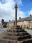 Upload another image | |
| Findlater Castle, Dovecote | Sandend | NJ5399366742 | 57°41′17″N 2°46′24″W / 57.68815°N 2.773293°W / 57.68815; -2.773293 (Findlater Castle, Dovecote) | [66] | 6759 |  Upload another image | |
| Glassaugh Windmill | Sandend | NJ5601665713 | 57°40′45″N 2°44′21″W / 57.679111°N 2.739178°W / 57.679111; -2.739178 (Glassaugh Windmill) | [67] | 6761 |  Upload another image | |
| Bridge of Keig over River Don | Keig | NJ6179218681 | 57°15′26″N 2°38′06″W / 57.257199°N 2.634964°W / 57.257199; -2.634964 (Bridge of Keig over River Don) | [68] | 9057 | Upload Photo | |
| Aquhorthies House | Aquhorthies, Inverurie | NJ7289220014 | 57°16′12″N 2°27′04″W / 57.269968°N 2.451128°W / 57.269968; -2.451128 (Aquhorthies House) | [69] | 9073 |  Upload another image | |
| Auchmacoy Dovecot | Ellon | 16 April 1971 | NJ9897331419 | 57°22′24″N 2°01′07″W / 57.373225°N 2.018724°W / 57.373225; -2.018724 (Auchmacoy Dovecot) | [70] | 9089 |  Upload another image |
| Kildrummy Parish Church | Kildrummy | NJ4722717579 | 57°14′45″N 2°52′34″W / 57.245849°N 2.876125°W / 57.245849; -2.876125 (Kildrummy Parish Church) | [71] | 9093 |  Upload another image | |
| Kildrummy Castle | Kildrummy | NJ4548516390 | 57°14′06″N 2°54′17″W / 57.234965°N 2.904726°W / 57.234965; -2.904726 (Kildrummy Castle) | [72] | 9098 |  Upload another image | |
| Nether Ardgrain, Farmhouse | Ellon | 16 April 1971 | NJ9529533957 | 57°23′46″N 2°04′48″W / 57.395999°N 2.079931°W / 57.395999; -2.079931 (Nether Ardgrain, Farmhouse) | [73] | 9106 |  Upload another image |
| Old Parish Church | Kirkton of Glenbuchat, Strathdon | NJ3756515132 | 57°13′22″N 3°02′08″W / 57.222653°N 3.035587°W / 57.222653; -3.035587 (Old Parish Church) | [74] | 9126 |  Upload another image | |
| Glenbuchat Castle | Glenbuchat, Strathdon | NJ3971614879 | 57°13′14″N 3°00′00″W / 57.22067°N 2.999911°W / 57.22067; -2.999911 (Glenbuchat Castle) | [75] | 9129 |  Upload another image | |
| Keith Hall | Inverurie | NJ7879721193 | 57°16′51″N 2°21′12″W / 57.280872°N 2.353319°W / 57.280872; -2.353319 (Keith Hall) | [76] | 9136 | Upload Photo | |
| Balbithan House | Kintore | NJ8121418877 | 57°15′37″N 2°18′47″W / 57.260174°N 2.313055°W / 57.260174; -2.313055 (Balbithan House) | [77] | 9140 | Upload Photo | |
| Beldorney Castle | River Deveron, west of Huntly | NJ4225936980 | 57°25′10″N 2°57′47″W / 57.419498°N 2.962985°W / 57.419498; -2.962985 (Beldorney Castle) | [78] | 9164 |  Upload another image | |
| Foveran Parish Church Turing Slab | Foveran | NJ9849424141 | 57°18′28″N 2°01′36″W / 57.307847°N 2.026641°W / 57.307847; -2.026641 (Foveran Parish Church Turing Slab) | [79] | 9166 | Upload Photo | |
| Leith Hall | Kennethmont, Rhynie | NJ5408629789 | 57°21′23″N 2°45′53″W / 57.35626°N 2.764752°W / 57.35626; -2.764752 (Leith Hall) | [80] | 9183 | 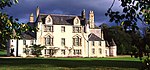 Upload another image | |
| Kemnay House | Kemnay | NJ7336715369 | 57°13′42″N 2°26′34″W / 57.228272°N 2.442751°W / 57.228272; -2.442751 (Kemnay House) | [81] | 9212 |  Upload another image | |
| Mains of Hallhead | Hallhead | NJ5248309096 | 57°10′13″N 2°47′15″W / 57.170231°N 2.787415°W / 57.170231; -2.787415 (Mains of Hallhead) | [82] | 9218 |  Upload another image | |
| Craigievar Castle | Alford | NJ5667809486 | 57°10′27″N 2°43′05″W / 57.174151°N 2.718118°W / 57.174151; -2.718118 (Craigievar Castle) | [83] | 9229 | 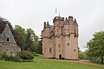 Upload another image | |
| Cairness House | Fraserburgh | 16 April 1971 | NK0383160917 | 57°38′17″N 1°56′15″W / 57.638177°N 1.937497°W / 57.638177; -1.937497 (Cairness House) | [84] | 9263 |  Upload another image |
| Cairness House, Lodges and Gates | Fraserburgh | 16 April 1971 | NK0407561039 | 57°38′21″N 1°56′00″W / 57.639271°N 1.933408°W / 57.639271; -1.933408 (Cairness House, Lodges and Gates) | [85] | 9264 |  Upload another image |
| Crimonmogate House | Crimond | 16 April 1971 | NK0399258699 | 57°37′06″N 1°56′05″W / 57.618253°N 1.934836°W / 57.618253; -1.934836 (Crimonmogate House) | [86] | 9270 | 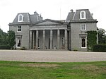 Upload another image |
| Muchalls Castle | Muchalls | NO8918191838 | 57°01′03″N 2°10′47″W / 57.017543°N 2.179804°W / 57.017543; -2.179804 (Muchalls Castle) | [87] | 9352 | 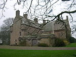 Upload another image | |
| Craigston Castle | Turriff | NJ7622155021 | 57°35′05″N 2°23′58″W / 57.5846°N 2.399342°W / 57.5846; -2.399342 (Craigston Castle) | [88] | 9392 |  Upload another image | |
| Old Parish Church of Longside | Longside | 16 April 1971 | NJ0374447226 | 57°30′55″N 1°56′21″W / 57.5152°N 1.9391°W / 57.5152; -1.9391 (Old Parish Church of Longside) | [89] | 9410 |  Upload another image |
| Churchyard Gateway, Longside Parish Church | Longside, Inn Brae | 16 April 1971 | NJ0373647258 | 57°30′56″N 1°56′21″W / 57.5155°N 1.9393°W / 57.5155; -1.9393 (Churchyard Gateway, Longside Parish Church) | [90] | 9412 |  Upload another image |
| Frendraught House | Glen Dronach, Aberchirder | NJ6208841887 | 57°27′56″N 2°38′01″W / 57.465663°N 2.633641°W / 57.465663; -2.633641 (Frendraught House) | [91] | 9449 | 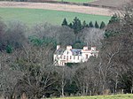 Upload another image | |
| Balbegno Castle Garden And Terrace Walls And Gatepiers | Fettercairn | NO6394372954 | 56°50′48″N 2°35′34″W / 56.846624°N 2.592729°W / 56.846624; -2.592729 (Balbegno Castle Garden And Terrace Walls And Gatepiers) | [92] | 9495 | Upload Photo | |
| Balbegno Castle, Dovecot | Fettercairn | NO6402072990 | 56°50′49″N 2°35′29″W / 56.846953°N 2.591472°W / 56.846953; -2.591472 (Balbegno Castle, Dovecot) | [93] | 9497 |  Upload another image | |
| Fasque House | Fettercairn | NO6483075525 | 56°52′11″N 2°34′43″W / 56.869787°N 2.578545°W / 56.869787; -2.578545 (Fasque House) | [94] | 9503 |  Upload another image | |
| Fyvie Castle | Fyvie | NJ7639039306 | 57°26′36″N 2°23′42″W / 57.443453°N 2.394986°W / 57.443453; -2.394986 (Fyvie Castle) | [95] | 9615 |  Upload another image | |
| St Palladius Episcopal Church | Drumtochty, Auchenblae | NO7074379874 | 56°54′33″N 2°28′55″W / 56.909266°N 2.482056°W / 56.909266; -2.482056 (St Palladius Episcopal Church) | [96] | 9634 |  Upload another image | |
| Phesdo House | Fettercairn | NO6758675634 | 56°52′15″N 2°32′00″W / 56.870968°N 2.533352°W / 56.870968; -2.533352 (Phesdo House) | [97] | 9646 | Upload Photo | |
| Drumtochty Castle | Drumtochty, Auchenblae | NO6998480047 | 56°54′39″N 2°29′40″W / 56.910772°N 2.49454°W / 56.910772; -2.49454 (Drumtochty Castle) | [98] | 9664 |  Upload another image | |
| Troup Home Farm, Kiln Barn and Cart Shed | Gardenstown | NJ8321165686 | 57°40′51″N 2°16′59″W / 57.680711°N 2.283187°W / 57.680711; -2.283187 (Troup Home Farm, Kiln Barn and Cart Shed) | [99] | 10585 | Upload Photo | |
| Birkenbog House | Fordyce | NJ5366365117 | 57°40′25″N 2°46′43″W / 57.673521°N 2.778514°W / 57.673521; -2.778514 (Birkenbog House) | [100] | 10586 |  Upload another image | |
| Fordyce Castle | Fordyce | NJ5557963797 | 57°39′43″N 2°44′46″W / 57.661859°N 2.746151°W / 57.661859; -2.746151 (Fordyce Castle) | [101] | 10623 |  Upload another image | |
| Glassaugh House Dovecot | Fordyce | NJ5590264787 | 57°40′15″N 2°44′27″W / 57.670783°N 2.74092°W / 57.670783; -2.74092 (Glassaugh House Dovecot) | [102] | 10650 | Upload Photo | |
| Glassaugh House | Fordyce | NJ5582964773 | 57°40′14″N 2°44′32″W / 57.67065°N 2.742141°W / 57.67065; -2.742141 (Glassaugh House) | [103] | 10694 | Upload Photo | |
| Forglen House | Turriff | NJ6988751856 | 57°33′21″N 2°30′18″W / 57.555793°N 2.504875°W / 57.555793; -2.504875 (Forglen House) | [104] | 13603 |  Upload another image | |
| Bridge of Dye over Water of Dye | South of Strachan | NO6510786079 | 56°57′53″N 2°34′32″W / 56.964614°N 2.575459°W / 56.964614; -2.575459 (Bridge of Dye over Water of Dye) | [105] | 13878 |  Upload another image | |
| Terpersie Castle | Alford | NJ5464420230 | 57°16′14″N 2°45′13″W / 57.270458°N 2.75372°W / 57.270458; -2.75372 (Terpersie Castle) | [106] | 13879 | 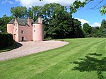 Upload another image | |
| Marykirk Bridge over River North Esk | Marykirk | NO6859765008 | 56°46′32″N 2°30′56″W / 56.775583°N 2.515455°W / 56.775583; -2.515455 (Marykirk Bridge over River North Esk) | [107][note 3] | 13891 | Upload Photo | |
| Upper North Water Bridge over River North Esk | Marykirk[note 3] | NO6527166139 | 56°47′08″N 2°34′12″W / 56.785506°N 2.570029°W / 56.785506; -2.570029 (Upper North Water Bridge over River North Esk) | [108] | 13892 | 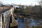 Upload another image | |
| Mounthooley Dovecot | Mounthooley, Rosehearty | 16 April 1971 | NJ9247065945 | 57°41′00″N 2°07′41″W / 57.68329°N 2.127938°W / 57.68329; -2.127938 (Mounthooley Dovecot) | [109] | 15909 |  Upload another image |
| Hill Kirk (Pitsligo Parish Church of Scotland) | Peathill, Rosehearty | 16 April 1971 | NJ9343866285 | 57°41′11″N 2°06′42″W / 57.686359°N 2.111715°W / 57.686359; -2.111715 (Hill Kirk (Pitsligo Parish Church of Scotland)) | [110] | 15911 |  Upload another image |
| Old Church of Scotland, Peathill | Peathill, Rosehearty | 16 April 1971 | NJ9339266241 | 57°41′09″N 2°06′45″W / 57.685963°N 2.112485°W / 57.685963; -2.112485 (Old Church of Scotland, Peathill) | [111] | 15912 |  Upload another image |
| Mains of Pittendrum House | Sandhaven | 16 April 1971 | NJ9644567007 | 57°41′34″N 2°03′41″W / 57.692879°N 2.061295°W / 57.692879; -2.061295 (Mains of Pittendrum House) | [112] | 15914 |  Upload another image |
| Udny Castle | Pitmedden | 16 April 1971 | NJ8822026789 | 57°19′53″N 2°11′50″W / 57.331481°N 2.197298°W / 57.331481; -2.197298 (Udny Castle) | [113] | 15922 | 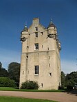 Upload another image |
| Pitmedden Great Garden | Pitmedden | 16 April 1971 | NJ8854728039 | 57°20′34″N 2°11′31″W / 57.342718°N 2.191926°W / 57.342718; -2.191926 (Pitmedden Great Garden) | [114] | 15925 |  Upload another image |
| Glenkindie House | Glenbuchat, Strathdon | NJ4226914452 | 57°13′02″N 2°57′27″W / 57.217164°N 2.957542°W / 57.217164; -2.957542 (Glenkindie House) | [115] | 15945 | Upload Photo | |
| House of Monymusk | Monymusk | NJ6888615461 | 57°13′44″N 2°31′01″W / 57.228814°N 2.516977°W / 57.228814; -2.516977 (House of Monymusk) | [116] | 15967 | 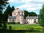 Upload another image | |
| Tolquhon Castle | Pitmedden | 16 April 1971 | NJ8726628627 | 57°20′53″N 2°12′48″W / 57.347966°N 2.213239°W / 57.347966; -2.213239 (Tolquhon Castle) | [117] | 15980 |  Upload another image |
| Monymusk Parish Church | Monymusk | NJ6848615248 | 57°13′37″N 2°31′25″W / 57.226874°N 2.523574°W / 57.226874; -2.523574 (Monymusk Parish Church) | [118] | 15987 | 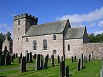 Upload another image | |
| Market Cross | Old Rayne | NJ6746728308 | 57°20′39″N 2°32′32″W / 57.344112°N 2.542173°W / 57.344112; -2.542173 (Market Cross) | [119] | 16019 | Upload Photo | |
| Straloch House | Newmachar | NJ8607021057 | 57°16′48″N 2°13′58″W / 57.279931°N 2.232682°W / 57.279931; -2.232682 (Straloch House) | [120] | 16125 | Upload Photo | |
| Harthill Castle | Oyne | NJ6865925175 | 57°18′58″N 2°31′19″W / 57.316055°N 2.52197°W / 57.316055; -2.52197 (Harthill Castle) | [121] | 16132 |  Upload another image | |
| Westhall House | Oyne | NJ6734326652 | 57°19′45″N 2°32′38″W / 57.329229°N 2.544013°W / 57.329229; -2.544013 (Westhall House) | [122] | 16134 |  Upload another image | |
| Cairnbulg Castle | Cairnbulg | NK0168663964 | 57°39′56″N 1°58′24″W / 57.665558°N 1.973403°W / 57.665558; -1.973403 (Cairnbulg Castle) | [123] | 16143 |  Upload another image | |
| House of Memsie | Memsie | 16 April 1971 | NJ9730461247 | 57°38′28″N 2°02′49″W / 57.641147°N 2.046819°W / 57.641147; -2.046819 (House of Memsie) | [124] | 16146 |  Upload another image |
| Skellater House | Strathdon | NJ3146510767 | 57°10′57″N 3°08′07″W / 57.182577°N 3.13538°W / 57.182577; -3.13538 (Skellater House) | [125] | 16173 | Upload Photo | |
| Corgarff Castle | Corgarff | NJ2545208669 | 57°09′46″N 3°14′03″W / 57.162796°N 3.234196°W / 57.162796; -3.234196 (Corgarff Castle) | [126] | 16178 | 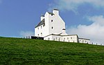 Upload another image | |
| Montgarrie Meal Mill | Montgarrie, Alford | NJ5747117722 | 57°14′54″N 2°42′23″W / 57.248203°N 2.706416°W / 57.248203; -2.706416 (Montgarrie Meal Mill) | [127] | 16207 | Upload Photo | |
| Meldrum House, outer gate and stable and coachhouse block | Oldmeldrum | 16 April 1971 | NJ8121729095 | 57°21′07″N 2°18′50″W / 57.351959°N 2.313786°W / 57.351959; -2.313786 (Meldrum House, outer gate and stable and coachhouse block) | [128] | 16225 |  Upload another image |
| Lickleyhead Castle | Auchleven | NJ6272423663 | 57°18′07″N 2°37′13″W / 57.302026°N 2.620269°W / 57.302026; -2.620269 (Lickleyhead Castle) | [129] | 16234 | 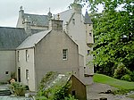 Upload another image | |
| Midmar Castle | Westhill | NJ7045205247 | 57°08′14″N 2°29′23″W / 57.13717°N 2.489824°W / 57.13717; -2.489824 (Midmar Castle) | [130] | 16262 |  Upload another image | |
| Midmar Castle, sundial | Westhill | NJ7044105240 | 57°08′14″N 2°29′24″W / 57.137106°N 2.490005°W / 57.137106; -2.490005 (Midmar Castle, sundial) | [131] | 16263 | Upload Photo | |
| Midmar Castle, walled garden | Westhill | NJ7049605246 | 57°08′14″N 2°29′21″W / 57.137164°N 2.489097°W / 57.137164; -2.489097 (Midmar Castle, walled garden) | [132] | 16264 | Upload Photo | |
| Linton House | Sauchen | NJ7050310012 | 57°10′48″N 2°29′22″W / 57.179976°N 2.489547°W / 57.179976; -2.489547 (Linton House) | [133] | 16274 | Upload Photo | |
| Balmanno House | Marykirk | NO6913766508 | 56°47′21″N 2°30′24″W / 56.789094°N 2.506801°W / 56.789094; -2.506801 (Balmanno House) | [134] | 16278 | Upload Photo | |
| Inglismaldie Castle, Dovecot | Marykirk | NO6422866573 | 56°47′22″N 2°35′14″W / 56.789325°N 2.587159°W / 56.789325; -2.587159 (Inglismaldie Castle, Dovecot) | [135] | 16289 |  Upload another image | |
| Forebank House | Marykirk | NO7009564722 | 56°46′23″N 2°29′27″W / 56.773113°N 2.490911°W / 56.773113; -2.490911 (Forebank House) | [136] | 16328 |  Upload another image | |
| Lower North Water Bridge over River North Esk | Marykirk[note 3] | NO7245862178 | 56°45′01″N 2°27′07″W / 56.750405°N 2.451975°W / 56.750405; -2.451975 (Lower North Water Bridge over River North Esk) | [137] | 16330 |  Upload another image | |
| Buchan Ness Lighthouse | Boddam | 16 April 1971 | NK1362442263 | 57°28′14″N 1°46′28″W / 57.470433°N 1.774514°W / 57.470433; -1.774514 (Buchan Ness Lighthouse) | [138] | 16367 |  Upload another image |
| Towie Barclay Castle | Turriff | NJ7443443936 | 57°29′06″N 2°25′41″W / 57.484935°N 2.428058°W / 57.484935; -2.428058 (Towie Barclay Castle) | [139] | 16405 | 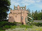 Upload another image | |
| Delgatie Castle | Turriff | NJ7544550532 | 57°32′39″N 2°24′43″W / 57.544238°N 2.411864°W / 57.544238; -2.411864 (Delgatie Castle) | [140] | 16421 |  Upload another image | |
| Hatton Castle | Turriff | NJ7571346976 | 57°30′44″N 2°24′25″W / 57.512311°N 2.407031°W / 57.512311; -2.407031 (Hatton Castle) | [141] | 16431 |  Upload another image | |
| Episcopal Church of St. John the Evangelist | New Pitsligo, High Street | 16 April 1971 | NJ8829655913 | 57°35′35″N 2°11′51″W / 57.59309°N 2.197443°W / 57.59309; -2.197443 (Episcopal Church of St. John the Evangelist) | [142] | 16440 |  Upload another image |
| Haddo House | Tarves | NJ8685334753 | 57°24′11″N 2°13′14″W / 57.402981°N 2.220432°W / 57.402981; -2.220432 (Haddo House) | [143] | 16470 |  Upload another image | |
| Tower lodges and gates and Loch of Skene boathouse, Dunecht House | Dunecht | NJ7854308046 | 57°09′46″N 2°21′23″W / 57.162764°N 2.356391°W / 57.162764; -2.356391 (Tower lodges and gates and Loch of Skene boathouse, Dunecht House) | [144] | 16505 |  Upload another image | |
| Garlogie Village Hall, Turbine and Engine House | Garlogie | NJ7822505494 | 57°08′23″N 2°21′41″W / 57.139825°N 2.361425°W / 57.139825; -2.361425 (Garlogie Village Hall, Turbine and Engine House) | [145] | 16506 | 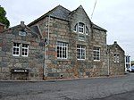 Upload another image | |
| Skene House | Skene | NJ7678409702 | 57°10′39″N 2°23′08″W / 57.177553°N 2.385627°W / 57.177553; -2.385627 (Skene House) | [146] | 16530 | 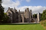 Upload another image | |
| Strichen Town House | Strichen, High Street | 16 April 1971 | NJ9466855163 | 57°35′11″N 2°05′27″W / 57.586475°N 2.090836°W / 57.586475; -2.090836 (Strichen Town House) | [147] | 16551 |  Upload another image |
| Blairs College New Chapel | Maryculter | NJ8833400914 | 57°05′57″N 2°11′39″W / 57.099053°N 2.194179°W / 57.099053; -2.194179 (Blairs College New Chapel) | [148] | 19227 |  Upload another image | |
| Castle of Park (Park House) | Cornhill | NJ5890357142 | 57°36′09″N 2°41′22″W / 57.602403°N 2.689313°W / 57.602403; -2.689313 (Castle of Park (Park House)) | [149] | 19597 |  Upload another image | |
| Crombie Castle | Marnoch, Aberchirder | NJ5910252250 | 57°33′31″N 2°41′07″W / 57.558482°N 2.685157°W / 57.558482; -2.685157 (Crombie Castle) | [150] | 19602 |  Upload another image | |
| Kinnairdy Castle | Marnoch, Aberchirder | NJ6089249812 | 57°32′12″N 2°39′17″W / 57.536743°N 2.654851°W / 57.536743; -2.654851 (Kinnairdy Castle) | [151] | 19606 |  Upload another image | |
| Marnoch Graveyard | Marnoch, Aberchirder | NJ5949149928 | 57°32′16″N 2°40′42″W / 57.537662°N 2.678268°W / 57.537662; -2.678268 (Marnoch Graveyard) | [152] | 19610 | 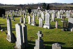 Upload another image | |
| Tolquhon Monument, Tarves Churchyard | Tarves | 16 April 1971 | NJ8690631179 | 57°22′15″N 2°13′10″W / 57.370879°N 2.219358°W / 57.370879; -2.219358 (Tolquhon Monument, Tarves Churchyard) | [153] | 19770 | 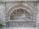 Upload another image |
| Banff Town and Country Club | Banff, Boyndie Street | NJ6883264023 | 57°39′54″N 2°31′27″W / 57.665005°N 2.524075°W / 57.665005; -2.524075 (Banff Town and Country Club) | [154] | 21885 | Upload Photo | |
| Bridge of Banff over River Deveron | Banff | NJ6947363779 | 57°39′46″N 2°30′48″W / 57.662857°N 2.513301°W / 57.662857; -2.513301 (Bridge of Banff over River Deveron) | [155] | 21893 |  Upload another image | |
| Banff Town Hall | Banff, Castle Street | NJ6883864205 | 57°40′00″N 2°31′26″W / 57.66664°N 2.523998°W / 57.66664; -2.523998 (Banff Town Hall) | [156] | 21941 | 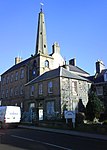 Upload another image | |
| Banff Castle | Banff, Castle Street | NJ6893664201 | 57°40′00″N 2°31′20″W / 57.666611°N 2.522355°W / 57.666611; -2.522355 (Banff Castle) | [157] | 21957 |  Upload another image | |
| Duff House | Banff | NJ6906363317 | 57°39′31″N 2°31′12″W / 57.658679°N 2.520113°W / 57.658679; -2.520113 (Duff House) | [158] | 21985 |  Upload another image | |
| Duff House, Mausoleum | Banff | NJ6804362826 | 57°39′15″N 2°32′14″W / 57.654198°N 2.53714°W / 57.654198; -2.53714 (Duff House, Mausoleum) | [159] | 21988 |  Upload another image | |
| Old St Mary's Burial Ground | Banff, Church Street | NJ6904864056 | 57°39′55″N 2°31′14″W / 57.665316°N 2.520459°W / 57.665316; -2.520459 (Old St Mary's Burial Ground) | [160] | 22003 |  Upload another image | |
| 1 High Shore | Banff | NJ6901164008 | 57°39′54″N 2°31′16″W / 57.664882°N 2.521073°W / 57.664882; -2.521073 (1 High Shore) | [161] | 22004 |  Upload another image | |
| Banff Primary School (former Banff Academy) | Banff, Institution Terrace | NJ6881463761 | 57°39′46″N 2°31′28″W / 57.66265°N 2.524343°W / 57.66265; -2.524343 (Banff Primary School (former Banff Academy)) | [162] | 22035 | Upload Photo | |
| 8-16 (even nos) Low Street, (former Fife Arms) | Banff | NJ6899663834 | 57°39′48″N 2°31′17″W / 57.663318°N 2.521302°W / 57.663318; -2.521302 (8-16 (even nos) Low Street, (former Fife Arms)) | [163] | 22056 |  Upload another image | |
| Tolbooth Steeple | Banff, Low Street | NJ6898963949 | 57°39′52″N 2°31′17″W / 57.664351°N 2.521434°W / 57.664351; -2.521434 (Tolbooth Steeple) | [164] | 22062 |  Upload another image | |
| Town House | Banff, Low Street | NJ6898863963 | 57°39′52″N 2°31′17″W / 57.664477°N 2.521453°W / 57.664477; -2.521453 (Town House) | [165] | 22063 | Upload another image | |
| Quayside, Banff Harbour | Banff | NJ6888364581 | 57°40′12″N 2°31′24″W / 57.67002°N 2.523293°W / 57.67002; -2.523293 (Quayside, Banff Harbour) | [166] | 22077 |  Upload another image | |
| St Catherine's | Banff, St Catherine Street | NJ6884264326 | 57°40′04″N 2°31′26″W / 57.667727°N 2.523947°W / 57.667727; -2.523947 (St Catherine's) | [167] | 22098 | Upload Photo | |
| Ingleneuk House | Banff, Water Path | NJ6898864055 | 57°39′55″N 2°31′17″W / 57.665303°N 2.521465°W / 57.665303; -2.521465 (Ingleneuk House) | [168] | 22111 | Upload Photo | |
| Ellon Castle (Old) Sundial at Central Avenue of Garden | Ellon | NJ9600030669 | 57°21′59″N 2°04′05″W / 57.366471°N 2.068146°W / 57.366471; -2.068146 (Ellon Castle (Old) Sundial at Central Avenue of Garden) | [169] | 31108 |  Upload another image | |
| Old Bridge of Ellon | Ellon | 16 April 1971 | NJ9569930333 | 57°21′48″N 2°04′23″W / 57.36345°N 2.073144°W / 57.36345; -2.073144 (Old Bridge of Ellon) | [170] | 31110 |  Upload another image |
| St. Mary on the Rock Episcopal Church | Ellon | 16 April 1971 | NJ9578930139 | 57°21′42″N 2°04′18″W / 57.361708°N 2.071644°W / 57.361708; -2.071644 (St. Mary on the Rock Episcopal Church) | [171] | 31111 |  Upload another image |
| Market Cross Saltoun Square | Fraserburgh | 16 April 1971 | NJ9979167095 | 57°41′37″N 2°00′19″W / 57.693684°N 2.00517°W / 57.693684; -2.00517 (Market Cross Saltoun Square) | [172] | 31867 |  Upload another image |
| Custom House (formerly occupied by Bank of Scotland) | Fraserburgh, Broad Street | 16 April 1971 | NJ9979166932 | 57°41′32″N 2°00′19″W / 57.69222°N 2.00517°W / 57.69222; -2.00517 (Custom House (formerly occupied by Bank of Scotland)) | [173] | 31873 |  Upload another image |
| Kinnaird's Head Castle Lighthouse | Fraserburgh | 16 April 1971 | NJ9986467528 | 57°41′51″N 2°00′14″W / 57.697574°N 2.003946°W / 57.697574; -2.003946 (Kinnaird's Head Castle Lighthouse) | [174] | 31888 |  Upload another image |
| Wine Tower | Fraserburgh | 16 April 1971 | NJ9993767510 | 57°41′51″N 2°00′10″W / 57.697412°N 2.002721°W / 57.697412; -2.002721 (Wine Tower) | [175] | 31889 |  Upload another image |
| Gordon's Schools (original building only) | Huntly, Castle Road | NJ5308940302 | 57°27′02″N 2°47′00″W / 57.450584°N 2.783334°W / 57.450584; -2.783334 (Gordon's Schools (original building only)) | [176] | 34943 |  Upload another image | |
| St. Margaret's R.C. Church | Huntly, Westpark Street and Chapel Street | NJ5283840172 | 57°26′58″N 2°47′15″W / 57.449391°N 2.787491°W / 57.449391; -2.787491 (St. Margaret's R.C. Church) | [177] | 34945 | 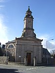 Upload another image | |
| Scott's Hospital | Huntly, Gladstone Road | NJ5322039670 | 57°26′42″N 2°46′52″W / 57.444921°N 2.781031°W / 57.444921; -2.781031 (Scott's Hospital) | [178] | 34962 |  Upload another image | |
| Old Bervie Bridge over Bervie Water | Inverbervie | NO8315172909 | 56°50′50″N 2°16′40″W / 56.847318°N 2.277842°W / 56.847318; -2.277842 (Old Bervie Bridge over Bervie Water) | [179] | 35070 |  Upload another image | |
| Kintore Town House | Kintore, The Square | NJ7923816317 | 57°14′14″N 2°20′44″W / 57.237093°N 2.345594°W / 57.237093; -2.345594 (Kintore Town House) | [180] | 36312 |  Upload another image | |
| Old St. Peter's Church | Peterhead, South Road | Delisted | NK1264746055 | 57°30′16″N 1°47′26″W / 57.504522°N 1.790607°W / 57.504522; -1.790607 (Old St. Peter's Church) | [181] | 39668 |  Upload another image |
| Peterhead Old Parish Church | Peterhead, Erroll Street | 16 April 1971 | NK1312046103 | 57°30′18″N 1°46′58″W / 57.50494°N 1.782712°W / 57.50494; -1.782712 (Peterhead Old Parish Church) | [182] | 39671 |  Upload another image |
| 23, 25 and 27 North High Street | Portsoy | NJ5887266218 | 57°41′02″N 2°41′29″W / 57.683917°N 2.69138°W / 57.683917; -2.69138 (23, 25 and 27 North High Street) | [183] | 40262 |  Upload another image | |
| 16, 18, 20 North High Street 'Old Star Inn' | Portsoy | NJ5888366217 | 57°41′02″N 2°41′28″W / 57.683909°N 2.691195°W / 57.683909; -2.691195 (16, 18, 20 North High Street 'Old Star Inn') | [184] | 40268 |  Upload another image | |
| 10 Shorehead | Portsoy | NJ5884866309 | 57°41′05″N 2°41′30″W / 57.684733°N 2.691798°W / 57.684733; -2.691798 (10 Shorehead) | [185] | 40292 |  Upload another image | |
| Corf Warehouse (Portsoy Marble) | Portsoy, Shorehead | NJ5885566331 | 57°41′06″N 2°41′30″W / 57.684931°N 2.691684°W / 57.684931; -2.691684 (Corf Warehouse (Portsoy Marble)) | [186] | 40293 |  Upload another image | |
| Old Harbour | Portsoy, Shorehead | NJ5889466347 | 57°41′06″N 2°41′28″W / 57.685078°N 2.691033°W / 57.685078; -2.691033 (Old Harbour) | [187] | 40296 | Upload another image | |
| St James the Great Episcopal Church | Stonehaven, Arbuthnott Street | NO8733285710 | 56°57′45″N 2°12′36″W / 56.962447°N 2.209944°W / 56.962447; -2.209944 (St James the Great Episcopal Church) | [188] | 41552 |  Upload another image | |
| Rivendell, former textile yard including sea wall | Stonehaven, Keith Place | NO8772185557 | 56°57′40″N 2°12′13″W / 56.961083°N 2.20354°W / 56.961083; -2.20354 (Rivendell, former textile yard including sea wall) | [189] | 41638 | Upload Photo | |
| Old Tolbooth of Stonehaven | Stonehaven, Old Pier | NO8780485521 | 56°57′39″N 2°12′08″W / 56.960762°N 2.202173°W / 56.960762; -2.202173 (Old Tolbooth of Stonehaven) | [190] | 41655 |  Upload another image | |
| Old Parish Church of St. Congan | Turriff | NJ7223149831 | 57°32′16″N 2°27′56″W / 57.537755°N 2.465474°W / 57.537755; -2.465474 (Old Parish Church of St. Congan) | [191] | 42163 | 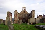 Upload another image | |
| St Thomas's Episcopal Church | Aboyne, Ballater Road | NO5201698556 | 57°04′32″N 2°47′35″W / 57.07551°N 2.79311°W / 57.07551; -2.79311 (St Thomas's Episcopal Church) | [192] | 47053 |  Upload another image | |
| Auchtavan, Cottage | Auchtavan, Royal Deeside | NO2060095600 | 57°02′41″N 3°18′37″W / 57.044612°N 3.310246°W / 57.044612; -3.310246 (Auchtavan, Cottage) | [193] | 50074 |  Upload another image |
See also
Notes
- ^ Sometimes known as OSGB36, the grid reference (where provided) is based on the British national grid reference system used by the Ordnance Survey.
• "Guide to National Grid". Ordnance Survey. Retrieved 12 December 2007.
• "Get-a-map". Ordnance Survey. Retrieved 17 December 2007. - ^ Historic Environment Scotland assign a unique alphanumeric identifier to each designated site in Scotland, for listed buildings this always begins with "LB", for example "LB12345".
- ^ a b c Also in Angus, as it crosses River North Esk, which is the council boundary
References
- ^ Guide to the Protection of Scotland’s Listed Buildings (PDF). Historic Scotland. 2009. p. 4. ISBN 978-1-84917-013-0. Retrieved 5 May 2010.
- ^ "What is Listing?". Historic Scotland. Retrieved 5 May 2010.
- ^ a b Scottish Historic Environment Policy (PDF). Historic Scotland. October 2008. pp. 24–25. ISBN 978-1-84917-002-4. Retrieved 5 May 2010.
- ^ Guide to the Protection of Scotland’s Listed Buildings, p. 17.
- ^ "Arbuthnott House, North Bridge Over Arbuthnott Burn: Listed Building Report". Historic Scotland.
- ^ "Braemar Castle: Listed Building Report". Historic Scotland.
- ^ "Tilquhillie Castle: Listed Building Report". Historic Scotland.
- ^ "Park Bridge Over River Dee: Listed Building Report". Historic Scotland.
- ^ "Old Parish Church Of Auchindoir: Listed Building Report". Historic Scotland.
- ^ "Craig Castle: Listed Building Report". Historic Scotland.
- ^ "Druminnor Castle: Listed Building Report". Historic Scotland.
- ^ "Aberdour House: Listed Building Report". Historic Scotland.
- ^ "Orrok (Or Orrock) House: Listed Building Report". Historic Scotland.
- ^ "Mounie Castle, Original Block.: Listed Building Report". Historic Scotland.
- ^ "Benholm Castle: Listed Building Report". Historic Scotland.
- ^ "Kirktown Of Benholm, Former Parish Church Including Graveyard, Boundary Walls, Gatepiers And Gates: Listed Building Report". Historic Scotland.
- ^ "Bourtie Parish Church: Listed Building Report". Historic Scotland.
- ^ "Bourtie House: Listed Building Report". Historic Scotland.
- ^ "Barra Castle: Listed Building Report". Historic Scotland.
- ^ "Pitcaple Castle: Listed Building Report". Historic Scotland.
- ^ "Chapel Of Garioch, Churchyard Gateway. (Pittodrie's Yate): Listed Building Report". Historic Scotland.
- ^ "Arbuthnott Parish Kirk: Listed Building Report". Historic Scotland.
- ^ "Allardyce Castle: Listed Building Report". Historic Scotland.
- ^ "Allardyce Castle - Gate Piers: Listed Building Report". Historic Scotland.
- ^ "Arbuthnott House: Listed Building Report". Historic Scotland.
- ^ "Bridge Of Alvah: Listed Building Report". Historic Scotland.
- ^ "Duff House, Fishing Temple: Listed Building Report". Historic Scotland.
- ^ "Dunlugas House: Listed Building Report". Historic Scotland.
- ^ "Dunnottar Castle - Keep: Listed Building Report". Historic Scotland.
- ^ "Dunnottar Castle - Entrance Gateway And Guardrooms: Listed Building Report". Historic Scotland.
- ^ "Dunnottar Castle - Benholms Lodgings: Listed Building Report". Historic Scotland.
- ^ "Castle Fraser: Listed Building Report". Historic Scotland.
- ^ "Castle Fraser, Stableblock (Now Present Mansionhouse And Estate Office): Listed Building Report". Historic Scotland.
- ^ "Castle Fraser Sundial: Listed Building Report". Historic Scotland.
- ^ "Fraser Mausoleum Old Churchyard Of Cluny: Listed Building Report". Historic Scotland.
- ^ "Old Churchyard Of Cluny: Listed Building Report". Historic Scotland.
- ^ "Cluny Castle: Listed Building Report". Historic Scotland.
- ^ "Tillycairn Castle: Listed Building Report". Historic Scotland.
- ^ "Culsalmond Old Parish Church Culsalmond Burial Ground: Listed Building Report". Historic Scotland.
- ^ "Crathie Suspension Bridge Over River Dee: Listed Building Report". Historic Scotland.
- ^ "Crathie Girder Bridge Over River Dee: Listed Building Report". Historic Scotland.
- ^ "Abergeldie Castle: Listed Building Report". Historic Scotland.
- ^ "Old Invercauld Bridge (Bridge Of Dee): Listed Building Report". Historic Scotland.
- ^ "Auchanachie Castle: Listed Building Report". Historic Scotland.
- ^ "Parish Church Of Crimond Including Enclosing Walls Railings And Gates: Listed Building Report". Historic Scotland.
- ^ "Haddo House Mains Of Haddo: Listed Building Report". Historic Scotland.
- ^ "Finzean, Sawmill And Turning Mill, Including Lade, Weir, Sluice Gate, Generator House, Kiln, Stack, Smiddy, Former Bus Garage, Mill Cottage, Ancillary Structures And Bridge Over Water Feugh: Listed Building Report". Historic Scotland.
- ^ "Inchdrewer Castle: Listed Building Report". Historic Scotland.
- ^ "Potarch Bridge, Over River Dee: Listed Building Report". Historic Scotland.
- ^ "Finzean, Bucket Mill, Including Sawmill, Lade, Weir, Sluice Gate, Kiln, Stable And Cart House (Shop), And Cottage: Listed Building Report". Historic Scotland.
- ^ "Park House: Listed Building Report". Historic Scotland.
- ^ "Drum Castle: Listed Building Report". Historic Scotland.
- ^ "Aboyne, Rhu-Na-Haven Road, Rhu-Na-Haven, And Garden Ornaments, Including Statuary, Urns, Paving, Walls And Rustic Timber Ancillary Structure: Listed Building Report". Historic Scotland.
- ^ "Dunecht House: Listed Building Report". Historic Scotland.
- ^ "Echt Parish Church: Listed Building Report". Historic Scotland.
- ^ "Raemoir Hotel Annex - The Ha'hoose: Listed Building Report". Historic Scotland.
- ^ "Crathes Castle: Listed Building Report". Historic Scotland.
- ^ "Balfluig Castle: Listed Building Report". Historic Scotland.
- ^ "Braemar Village Castleton Terrace St Margaret's Episcopal Church: Listed Building Report". Historic Scotland.
- ^ "South Colleonard With Urns, Gates And Gatepiers: Listed Building Report". Historic Scotland.
- ^ "Gairnshiel Bridge Over River Gairn: Listed Building Report". Historic Scotland.
- ^ "Kincardine O'neil Auld Kirk: Listed Building Report". Historic Scotland.
- ^ "Castle Of Fiddes: Listed Building Report". Historic Scotland.
- ^ "Balbegno Castle: Listed Building Report". Historic Scotland.
- ^ "Fettercairn, Market Cross Of Fettercairn: Listed Building Report". Historic Scotland.
- ^ "Findlater Castle, Dovecote: Listed Building Report". Historic Scotland.
- ^ "Glassaugh Windmill: Listed Building Report". Historic Scotland.
- ^ "Bridge Of Keig Over River Don: Listed Building Report". Historic Scotland.
- ^ "Aquahorthies House: Listed Building Report". Historic Scotland.
- ^ "Auchmacoy Dovecot: Listed Building Report". Historic Scotland.
- ^ "Kildrummy Parish Church: Listed Building Report". Historic Scotland.
- ^ "Kildrummy Castle: Listed Building Report". Historic Scotland.
- ^ "Nether Ardgrain, Farmhouse: Listed Building Report". Historic Scotland.
- ^ "Old Parish Church: Listed Building Report". Historic Scotland.
- ^ "Glenbuchat Castle: Listed Building Report". Historic Scotland.
- ^ "Keith Hall: Listed Building Report". Historic Scotland.
- ^ "Balbithan House: Listed Building Report". Historic Scotland.
- ^ "Beldorney Castle: Listed Building Report". Historic Scotland.
- ^ "Foveran Parish Church Turing Slab: Listed Building Report". Historic Scotland.
- ^ "Leith Hall.: Listed Building Report". Historic Scotland.
- ^ "Kemnay House: Listed Building Report". Historic Scotland.
- ^ "Hallhead, Mains Of Hallhead.: Listed Building Report". Historic Scotland.
- ^ "Craigievar Castle: Listed Building Report". Historic Scotland.
- ^ "Cairness House: Listed Building Report". Historic Scotland.
- ^ "Cairness House Lodges And Gates: Listed Building Report". Historic Scotland.
- ^ "Crimonmogate House: Listed Building Report". Historic Scotland.
- ^ "Muchalls Castle: Listed Building Report". Historic Scotland.
- ^ "Craigston Castle: Listed Building Report". Historic Scotland.
- ^ "Old Parish Church Of Longside: Listed Building Report". Historic Scotland.
- ^ "Churchyard Gateway, Longside Parish Church: Listed Building Report". Historic Scotland.
- ^ "Frendraught House: Listed Building Report". Historic Scotland.
- ^ "Balbegno Castle Garden And Terrace Walls And Gatepiers: Listed Building Report". Historic Scotland.
- ^ "Balbegno Castle, Dovecot: Listed Building Report". Historic Scotland.
- ^ "Fasque House: Listed Building Report". Historic Scotland.
- ^ "Fyvie Castle: Listed Building Report". Historic Scotland.
- ^ "St Palladius Episcopal Church, Drumtochty: Listed Building Report". Historic Scotland.
- ^ "Phesdo House: Listed Building Report". Historic Scotland.
- ^ "Drumtochty Castle: Listed Building Report". Historic Scotland.
- ^ "Troup Home Farm, Kiln Barn And Cart Shed: Listed Building Report". Historic Scotland.
- ^ "Birkenbog House, Rear Walled Garden And Flanking Range: Listed Building Report". Historic Scotland.
- ^ "Fordyce Village, Fordyce Castle: Listed Building Report". Historic Scotland.
- ^ "Glassaugh House Dovecot: Listed Building Report". Historic Scotland.
- ^ "Glassaugh House: Listed Building Report". Historic Scotland.
- ^ "Forglen House: Listed Building Report". Historic Scotland.
- ^ "Bridge Of Dye Over Water Of Dye: Listed Building Report". Historic Scotland.
- ^ "Terpersie Castle: Listed Building Report". Historic Scotland.
- ^ "Marykirk Bridge Over River North Esk: Listed Building Report". Historic Scotland.
- ^ "Upper North Water Bridge: Listed Building Report". Historic Scotland.
- ^ "Mounthooley Dovecot: Listed Building Report". Historic Scotland.
- ^ "Peathill, Hill Kirk (Pitsligo Parish Church Of Scotland): Listed Building Report". Historic Scotland.
- ^ "Peathill, Old Church Of Scotland: Listed Building Report". Historic Scotland.
- ^ "Pittendrum, Mains Of Pittendrum House: Listed Building Report". Historic Scotland.
- ^ "Udny Castle: Listed Building Report". Historic Scotland.
- ^ "Pitmedden Great Garden: Listed Building Report". Historic Scotland.
- ^ "Glenkindie House: Listed Building Report". Historic Scotland.
- ^ "House Of Monymusk: Listed Building Report". Historic Scotland.
- ^ "Tolquhon Castle: Listed Building Report". Historic Scotland.
- ^ "Monymusk Parish Church (Augustinian Priory Church Of The Blessed Mary Of Monymusk): Listed Building Report". Historic Scotland.
- ^ "Market Cross, Old Rayne: Listed Building Report". Historic Scotland.
- ^ "Straloch House: Listed Building Report". Historic Scotland.
- ^ "Harthill Castle: Listed Building Report". Historic Scotland.
- ^ "Westhall House: Listed Building Report". Historic Scotland.
- ^ "Cairnbulg Castle: Listed Building Report". Historic Scotland.
- ^ "House Of Memsie: Listed Building Report". Historic Scotland.
- ^ "Skellater House: Listed Building Report". Historic Scotland.
- ^ "Corgarff Castle: Listed Building Report". Historic Scotland.
- ^ "Montgarrie Meal Mill: Listed Building Report". Historic Scotland.
- ^ "Meldrum House Outer Gate And Stable And Coachhouse Block: Listed Building Report". Historic Scotland.
- ^ "Lickleyhead Castle: Listed Building Report". Historic Scotland.
- ^ "Midmar Castle: Listed Building Report". Historic Scotland.
- ^ "Midmar Castle, Sundial: Listed Building Report". Historic Scotland.
- ^ "Midmar Castle, Walled Garden: Listed Building Report". Historic Scotland.
- ^ "Linton House: Listed Building Report". Historic Scotland.
- ^ "Balmanno House, Including Outbuildings Garden Walls And Coachhouse: Listed Building Report". Historic Scotland.
- ^ "Inglismaldie Castle, Dovecot: Listed Building Report". Historic Scotland.
- ^ "Forebank House Including Steading Outbuildings, Garden Walls Railings And Gates: Listed Building Report". Historic Scotland.
- ^ "Lower North Water Bridge Over North Esk, Including Approaches: Listed Building Report". Historic Scotland.
- ^ "Buchanness Lighthouse: Listed Building Report". Historic Scotland.
- ^ "Towie Barclay Castle: Listed Building Report". Historic Scotland.
- ^ "Delgatie Castle: Listed Building Report". Historic Scotland.
- ^ "Hatton Castle: Listed Building Report". Historic Scotland.
- ^ "Episcopal Church Of St. John The Evangelist, High Street Including Wall And Railings To High Street.: Listed Building Report". Historic Scotland.
- ^ "Haddo House: Listed Building Report". Historic Scotland.
- ^ "Tower Lodges And Gates And Loch Of Skene Boathouse, Dunecht House: Listed Building Report". Historic Scotland.
- ^ "Garlogie Village Hall, Turbine And Engine House: Listed Building Report". Historic Scotland.
- ^ "Skene House, Including Terrace And Garden Ornaments.: Listed Building Report". Historic Scotland.
- ^ "Town House High Street And Bridge Street: Listed Building Report". Historic Scotland.
- ^ "Blairs College New Chapel: Listed Building Report". Historic Scotland.
- ^ "Park: Listed Building Report". Historic Scotland.
- ^ "Crombie Castle: Listed Building Report". Historic Scotland.
- ^ "Kinnairdy Castle With Outbuildings: Listed Building Report". Historic Scotland.
- ^ "Marnoch Graveyard With Watchhouse, Burial Enclosures And Gravestones: Listed Building Report". Historic Scotland.
- ^ "Tolquhon Monument, Tarves Churchyard: Listed Building Report". Historic Scotland.
- ^ "11 Boyndie Street, Banff Town And Country Club And Enclosing Walls: Listed Building Report". Historic Scotland.
- ^ "Bridge Of Banff Over River Deveron: Listed Building Report". Historic Scotland.
- ^ "31, 33, 35 Castle Street And 2 Seafield Street, Town Hall: Listed Building Report". Historic Scotland.
- ^ "Castle Street, Banff Castle, With Flanking Pavilions, Well And Old Castle Walls: Listed Building Report". Historic Scotland.
- ^ "Duff House: Listed Building Report". Historic Scotland.
- ^ "Duff House Mausoleum: Listed Building Report". Historic Scotland.
- ^ "High Shore, Old St Mary's Burial Ground And Railings: Listed Building Report". Historic Scotland.
- ^ "1 High Shore: Listed Building Report". Historic Scotland.
- ^ "Institution Terrace, Banff Primary School (Former Banff Academy) With Lamp Standards: Listed Building Report". Historic Scotland.
- ^ "8-16 (Even Nos) Low Street, (Former Fife Arms), Fife House: Listed Building Report". Historic Scotland.
- ^ "Low Street, Tolbooth Steeple: Listed Building Report". Historic Scotland.
- ^ "34 Low Street, Townhouse: Listed Building Report". Historic Scotland.
- ^ "Quayside, Banff Harbour: Listed Building Report". Historic Scotland.
- ^ "1 St Catherine Street, St Catherine's: Listed Building Report". Historic Scotland.
- ^ "2 Water Path, Ingleneuk House Garden Walls And Garden Summer House: Listed Building Report". Historic Scotland.
- ^ "Ellon Castle (Old) Sundial At Central Avenue Of Garden.: Listed Building Report". Historic Scotland.
- ^ "Old Bridge Of Ellon: Listed Building Report". Historic Scotland.
- ^ "St. Mary On The Rock Episcopal Church, Ellon: Listed Building Report". Historic Scotland.
- ^ "Market Cross Saltoun Square: Listed Building Report". Historic Scotland.
- ^ "Custom House, (Formerly Occupied By Bank Of Scotland) Broad Street And Frithside Street: Listed Building Report". Historic Scotland.
- ^ "Kinnaird's Head Castle Lighthouse: Listed Building Report". Historic Scotland.
- ^ "Wine Tower: Listed Building Report". Historic Scotland.
- ^ "Gordon's Schools Original Building Only.: Listed Building Report". Historic Scotland.
- ^ "St. Margaret's R.C. Church, Westpark Street And Chapel Street: Listed Building Report". Historic Scotland.
- ^ "Scott's Hospital, Gladstone Road: Listed Building Report". Historic Scotland.
- ^ "Old Bervie Bridge Over Bervie Water: Listed Building Report". Historic Scotland.
- ^ "Kintore Town House The Square: Listed Building Report". Historic Scotland.
- ^ "Old St. Peter's Church: Listed Building Report". Historic Scotland.
- ^ "Peterhead Old Parish Church: Listed Building Report". Historic Scotland.
- ^ "23, 25 And 27 North High Street And Rear Garden Walls: Listed Building Report". Historic Scotland.
- ^ "16, 18, 20 North High Street 'Old Star Inn': Listed Building Report". Historic Scotland.
- ^ "10 Shorehead: Listed Building Report". Historic Scotland.
- ^ "Shorehead, Corf Warehouse (Portsoy Marble): Listed Building Report". Historic Scotland.
- ^ "Shorehead, Old Harbour: Listed Building Report". Historic Scotland.
- ^ "Arbuthnott Street, St James The Great Episcopal Church Including Boundary Walls, Gatepiers And Gates: Listed Building Report". Historic Scotland.
- ^ "Keith Place, Rivendell, Former Textile Yard Including Sea Wall: Listed Building Report". Historic Scotland.
- ^ "Old Pier, Old Tolbooth Of Stonehaven Including Boundary Walls And Gates: Listed Building Report". Historic Scotland.
- ^ "Old Parish Church Of St. Congan (Coav) Castle Street And Putachie Path: Listed Building Report". Historic Scotland.
- ^ "Aboyne, Ballater Road, St Thomas's Episcopal Church, Including Boiler House, Lych Gate, Gatepiers And Boundary Walls: Listed Building Report". Historic Scotland.
- ^ "Auchtavan, Cottage: Listed Building Report". Historic Scotland.
External links
![]() Media related to Category A listed buildings in Aberdeenshire at Wikimedia Commons
Media related to Category A listed buildings in Aberdeenshire at Wikimedia Commons
- v
- t
- e
- City of Aberdeen
- Aberdeenshire
- Angus
- Argyll and Bute
- Clackmannanshire
- Dumfries and Galloway
- City of Dundee
- East Ayrshire
- East Dunbartonshire
- East Lothian
- East Renfrewshire
- City of Edinburgh
- Falkirk
- Fife
- City of Glasgow
- Highland
- Inverclyde
- Midlothian
- Moray
- North Ayrshire
- North Lanarkshire
- Orkney
- Perth and Kinross
- Renfrewshire
- Scottish Borders
- Shetland
- South Ayrshire
- South Lanarkshire
- Stirling
- West Dunbartonshire
- West Lothian
- Western Isles (na h-Eileanan Siar)


