List of Category A listed buildings in the Scottish Borders

Map all coordinates using OpenStreetMap
Download coordinates as:
- KML
- GPX (all coordinates)
- GPX (primary coordinates)
- GPX (secondary coordinates)
This is a list of Category A listed buildings in the Scottish Borders council area in south-east Scotland.
In Scotland, the term listed building refers to a building or other structure officially designated as being of "special architectural or historic interest".[1] Category A structures are those considered to be "buildings of national or international importance, either architectural or historic, or fine little-altered examples of some particular period, style or building type."[2] Listing was begun by a provision in the Town and Country Planning (Scotland) Act 1947, and the current legislative basis for listing is the Planning (Listed Buildings and Conservation Areas) (Scotland) Act 1997.[3] The authority for listing rests with Historic Scotland, an executive agency of the Scottish Government, which inherited this role from the Scottish Development Department in 1991. Once listed, severe restrictions are imposed on the modifications allowed to a building's structure or its fittings. Listed building consent must be obtained from local authorities prior to any alteration to such a structure.[3] There are approximately 47,400 listed buildings in Scotland, of which around 8% (some 3,800) are Category A.[4]
The council area of the Scottish Borders covers 4,732 square kilometres (1,827 sq mi), and has a population of around 112,400. There are 182 Category A listed buildings in the area.
Listed buildings
| Name | Location | Date Listed | Grid Ref. [note 1] | Geo-coordinates | Notes | LB Number [note 2] | Image |
|---|---|---|---|---|---|---|---|
| Torwoodlee House | Torwoodlee, Galashiels | NT4718237978 | 55°37′57″N 2°50′26″W / 55.632483°N 2.840483°W / 55.632483; -2.840483 (Torwoodlee House) | Mansion built c. 1783.[5] | 135 |  Upload another image | |
| Cranshaws Church | Cranshaws | NT6923161843 | 55°50′56″N 2°29′35″W / 55.848803°N 2.49299°W / 55.848803; -2.49299 (Cranshaws Church) | Romanesque revival church built 1899.[6] | 201 |  Upload another image | |
| Old Ancrum Bridge | Ancrum | NT6387123750 | 55°30′22″N 2°34′25″W / 55.506177°N 2.573559°W / 55.506177; -2.573559 (Old Ancrum Bridge) | Late 18th century bridge with three arches.[7] | 224 |  Upload another image | |
| Parish Church of St Cuthbert | Channelkirk, Oxton | NT4815254505 | 55°46′52″N 2°49′42″W / 55.781069°N 2.828214°W / 55.781069; -2.828214 (Parish Church of St Cuthbert) | Dated 1817.[8] | 1893 |  Upload another image | |
| Yair House | Yair | NT4529132854 | 55°35′10″N 2°52′10″W / 55.586239°N 2.869495°W / 55.586239; -2.869495 (Yair House) | Georgian mansion built by Alexander Pringle of Whytbank.[9] | 1899 |  Upload another image | |
| Yair Bridge | Yair | NT4581532554 | 55°35′01″N 2°51′40″W / 55.583602°N 2.861124°W / 55.583602; -2.861124 (Yair Bridge) | Mid-18th century 3 arched bridge spanning the Tweed.[10] | 1901 | 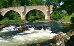 Upload another image | |
| Ashiestiel House | Ashiestiel | NT4303835143 | 55°36′24″N 2°54′21″W / 55.606545°N 2.905707°W / 55.606545; -2.905707 (Ashiestiel House) | Home of Walter Scott between 1804 and 1812[11] | 1902 |  Upload Photo | |
| Ashiestiel Bridge | Ashiestiel | NT4386735076 | 55°36′22″N 2°53′33″W / 55.606039°N 2.892536°W / 55.606039; -2.892536 (Ashiestiel Bridge) | Single arch spanning the Tweed, built 1847.[12] | 1903 |  Upload another image | |
| Peel Hospital | Ashiestiel | NT4316735079 | 55°36′22″N 2°54′13″W / 55.605985°N 2.903646°W / 55.605985; -2.903646 (Peel Hospital) | Built as a Baronial style mansion c. 1904-07.[13] | 1904 |  Upload another image | |
| Bowden Church and Graveyard | Bowden | NT5543330150 | 55°33′47″N 2°42′29″W / 55.56298°N 2.708174°W / 55.56298; -2.708174 (Bowden Church and Graveyard) | Early 17th century.[14] | 1920 |  Upload another image | |
| The Retreat | Abbey St Bathans | NT7716360894 | 55°50′27″N 2°21′58″W / 55.840719°N 2.36623°W / 55.840719; -2.36623 (The Retreat) | Late 18th century former hunting lodge.[15] | 1971 |  Upload another image | |
| Ayton Castle | Ayton | NT9289561379 | 55°50′44″N 2°06′54″W / 55.845569°N 2.115037°W / 55.845569; -2.115037 (Ayton Castle) | A large Scots Baronial house, built 1845-51 by James Gillespie Graham.[16] | 1987 |  Upload another image | |
| Ayton Castle, Dovecot | Ayton | NT9302361455 | 55°50′47″N 2°06′47″W / 55.846254°N 2.112995°W / 55.846254; -2.112995 (Ayton Castle, Dovecot) | 16th century circular-plan beehive dovecot.[17] | 1989 | Upload Photo | |
| Broughton Place | Broughton, Glenholm and Kilbucho | NT1169137236 | 55°37′14″N 3°24′14″W / 55.620662°N 3.403805°W / 55.620662; -3.403805 (Broughton Place) | Scottish country house designed by Sir Basil Spence, 1935-1938, with later alterations.[18] | 2031 | 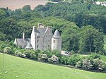 Upload another image | |
| Portmore House | Eddleston | NT2504448832 | 55°43′37″N 3°11′42″W / 55.727074°N 3.195003°W / 55.727074; -3.195003 (Portmore House) | Baronial style mansion, built 1850 by David Bryce, restored after fire in 1883.[19] | 2037 | Upload Photo | |
| Westgate Hall | Denholm | NT5678918307 | 55°27′24″N 2°41′05″W / 55.456696°N 2.684826°W / 55.456696; -2.684826 (Westgate Hall) | 17th century.[20] | 2052 |  Upload another image | |
| Crailing House | Crailing | NT6886224362 | 55°30′43″N 2°29′41″W / 55.51202°N 2.494613°W / 55.51202; -2.494613 (Crailing House) | Built 1803, designed by local architect, William Elliot.[21] | 2080 | Upload Photo | |
| Cowdenknowes | Earlston | NT5772837038 | 55°37′30″N 2°40′22″W / 55.625071°N 2.672848°W / 55.625071; -2.672848 (Cowdenknowes) | 16th century mansion house.[22] | 2120 | 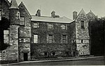 Upload another image | |
| Mellerstain House | Gordon | NT6476539095 | 55°38′39″N 2°33′41″W / 55.644115°N 2.56137°W / 55.644115; -2.56137 (Mellerstain House) | The two wings built 1725 by William Adam, the main block by his son Robert about 40 years later.[23] | 2123 | 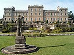 Upload another image | |
| Mellerstain House, Stables and Cottage Block | Gordon | NT6471939101 | 55°38′39″N 2°33′44″W / 55.644165°N 2.562102°W / 55.644165; -2.562102 (Mellerstain House, Stables and Cottage Block) | [24] | 2124 | Upload Photo | |
| Edrom Parish Church | Edrom | NT8276055835 | 55°47′44″N 2°16′36″W / 55.795499°N 2.276536°W / 55.795499; -2.276536 (Edrom Parish Church) | Cross-plan church rebuilt 1737 utilising foundations of earlier church. 1886 Restoration with additions.[25] | 2127 |  Upload another image | |
| Nisbet House | Duns | NT7950151232 | 55°45′14″N 2°19′41″W / 55.754014°N 2.328166°W / 55.754014; -2.328166 (Nisbet House) | [26] | 2131 | 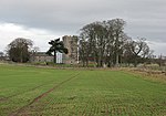 Upload another image | |
| Nisbet Dovecot | Nisbethill, Duns | NT7965350617 | 55°44′55″N 2°19′33″W / 55.748494°N 2.325698°W / 55.748494; -2.325698 (Nisbet Dovecot) | Unique pentagon-plan dovecot, built late 18th century.[27] | 2132 |  Upload another image | |
| Kalemouth Suspension Bridge, over River Teviot | Kalemouth | NT7084227453 | 55°32′24″N 2°27′49″W / 55.539916°N 2.463588°W / 55.539916; -2.463588 (Kalemouth Suspension Bridge, over River Teviot) | Chain-link suspension bridge, 180 ft (55 m) long, built c. 1830.[28] | 3849 |  Upload another image | |
| Wedderburn Castle, Lion Gate and Boundary Walls | Duns | NT8053053228 | 55°46′19″N 2°18′43″W / 55.77199°N 2.311915°W / 55.77199; -2.311915 (Wedderburn Castle, Lion Gate and Boundary Walls) | Built 1790s.[29] | 4029 |  Upload another image | |
| Manderston | Duns | NT8107554377 | 55°46′56″N 2°18′12″W / 55.782336°N 2.303308°W / 55.782336; -2.303308 (Manderston) | Classical house c. 1790, with reconstruction and extension by John Kinross, 1901-5.[30] | 4033 |  Upload another image | |
| Manderston, Stables | Duns | NT8079854640 | 55°47′05″N 2°18′28″W / 55.784688°N 2.307743°W / 55.784688; -2.307743 (Manderston, Stables) | Stable and carriage house block, dated 1895, by John Kinross.[31] | 4034 |  Upload another image | |
| Old Manor House (Sparrow Castle) | Cockburnspath | NT7747771049 | 55°55′55″N 2°21′43″W / 55.931974°N 2.362065°W / 55.931974; -2.362065 (Old Manor House (Sparrow Castle)) | [32] | 4046 | Upload Photo | |
| Market Cross | Cockburnspath, The Square | NT7743071100 | 55°55′57″N 2°21′46″W / 55.93243°N 2.362821°W / 55.93243; -2.362821 (Market Cross) | [33] | 4047 |  Upload another image | |
| Pease Bridge | A1107, Cockburnspath | NT7915369977 | 55°55′21″N 2°20′07″W / 55.922418°N 2.335157°W / 55.922418; -2.335157 (Pease Bridge) | Built 1786, with 4 arches spanning the Pease Glen.[34] | 4054 |  Upload another image | |
| Coldingham Priory | Coldingham | NT9039465949 | 55°53′12″N 2°09′19″W / 55.886586°N 2.155141°W / 55.886586; -2.155141 (Coldingham Priory) | On the site of an 11th century church which has been damaged and rebuilt several times. Remodeled in 1662 with further work in 1851-55.[35] | 4059 |  Upload another image | |
| Lennel House | Coldstream | NT8515140784 | 55°39′37″N 2°14′15″W / 55.660346°N 2.237578°W / 55.660346; -2.237578 (Lennel House) | [36] | 4068 |  Upload another image | |
| The Hirsel | Coldstream | NT8294440745 | 55°39′36″N 2°16′22″W / 55.659922°N 2.272654°W / 55.659922; -2.272654 (The Hirsel) | Georgian house, mostly early 18th century, with Victorian alterations and additions.[37] | 4069 |  Upload another image | |
| Coldstream Bridge | Coldstream | NT8488040130 | 55°39′16″N 2°14′31″W / 55.654461°N 2.241849°W / 55.654461; -2.241849 (Coldstream Bridge) | Built 1763-66 by John Smeaton with 20th century alterations[38][note 3] | 4075 |  Upload another image | |
| Cranshaws Castle | Cranshaws | NT6819561807 | 55°50′54″N 2°30′34″W / 55.848413°N 2.509531°W / 55.848413; -2.509531 (Cranshaws Castle) | Possibly late 14th century with later alterations.[39] | 4093 | 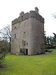 Upload another image | |
| Market Cross | Coldingham, The Square | NT9023665974 | 55°53′13″N 2°09′28″W / 55.886807°N 2.157668°W / 55.886807; -2.157668 (Market Cross) | Dated 1815.[40] | 4094 |  Upload another image | |
| Renton House | Grantshouse | NT8227465304 | 55°52′50″N 2°17′06″W / 55.880558°N 2.284909°W / 55.880558; -2.284909 (Renton House) | Early 18th century with later additions and alterations.[41] | 4105 |  Upload another image | |
| Duns Castle | Duns | NT7777554384 | 55°46′56″N 2°21′21″W / 55.782257°N 2.355923°W / 55.782257; -2.355923 (Duns Castle) | Tower house, c. 1320, incorporated in substantial later additions and alterations.[42] | 4108 |  Upload another image | |
| Bughtrig House | Leitholm | NT7959644797 | 55°41′46″N 2°19′34″W / 55.6962°N 2.32617°W / 55.6962; -2.32617 (Bughtrig House) | Late 18th to early 19th century house remodelled late 19th century.[43] | 4114 |  Upload another image | |
| Kames House | Leitholm | NT7826145464 | 55°42′08″N 2°20′51″W / 55.702134°N 2.347461°W / 55.702134; -2.347461 (Kames House) | [44] | 4115 | Upload Photo | |
| Preston Bridge | Preston | NT7872056783 | 55°48′14″N 2°20′28″W / 55.803855°N 2.341045°W / 55.803855; -2.341045 (Preston Bridge) | Humped-back 3-arched bridge dated 1770.[45] | 4120 |  Upload another image | |
| Ninewells Dovecot | Chirnside, Kirkgate | NT8699756167 | 55°47′55″N 2°12′32″W / 55.798615°N 2.208975°W / 55.798615; -2.208975 (Ninewells Dovecot) | 16th century.[46] | 4124 | Upload Photo | |
| Cockburnspath Church and Graveyard | Cockburnspath | NT7744571053 | 55°55′55″N 2°21′45″W / 55.932008°N 2.362577°W / 55.932008; -2.362577 (Cockburnspath Church and Graveyard) | [47] | 4129 |  Upload another image | |
| Chesters House | Ancrum | NT6084222512 | 55°29′41″N 2°37′17″W / 55.494819°N 2.621337°W / 55.494819; -2.621337 (Chesters House) | Late 18th century.[48] | 4174 | Upload Photo | |
| Dovecot, Knowesouth | Bedrule | NT6068321419 | 55°29′06″N 2°37′25″W / 55.484986°N 2.623698°W / 55.484986; -2.623698 (Dovecot, Knowesouth) | Late 18th century.[49] | 4182 | Upload Photo | |
| Chirnside Primary School | Chirnside | NT8712456118 | 55°47′53″N 2°12′25″W / 55.798179°N 2.206947°W / 55.798179; -2.206947 (Chirnside Primary School) | Built by Reid and Forbes, 1937-1938, with later additions and alterations.[50] | 6620 |  Upload another image | |
| Kirkhope Tower | Ettrickbridge | NT3787225053 | 55°30′55″N 2°59′08″W / 55.515263°N 2.98542°W / 55.515263; -2.98542 (Kirkhope Tower) | [51] | 6720 |  Upload another image | |
| Market Cross | Greenlaw, The Square | NT7114346038 | 55°42′25″N 2°27′39″W / 55.706919°N 2.460775°W / 55.706919; -2.460775 (Market Cross) | [52] | 6823 |  Upload another image | |
| Thirlestane Castle | Lauder | NT5338547902 | 55°43′20″N 2°44′37″W / 55.72228°N 2.743659°W / 55.72228; -2.743659 (Thirlestane Castle) | Late 16th century with later additions and alterations.[53] | 8203 |  Upload another image | |
| The Kirna, also known as Kirna House, and Grangehill | Walkerburn | NT3507637417 | 55°37′34″N 3°01′57″W / 55.625975°N 3.032601°W / 55.625975; -3.032601 (The Kirna, also known as Kirna House, and Grangehill) | Built by F T Pilkington, 1867, for George Ballantyne.[54] | 8323 |  Upload another image | |
| Prefabricated cast-iron urinal | Walkerburn, Galashiels Road | NT3588637179 | 55°37′26″N 3°01′11″W / 55.623945°N 3.019685°W / 55.623945; -3.019685 (Prefabricated cast-iron urinal) | Built c. 1897.[55] | 8326 |  Upload another image | |
| Longformacus House | Longformacus | NT6958257305 | 55°48′29″N 2°29′13″W / 55.808054°N 2.486875°W / 55.808054; -2.486875 (Longformacus House) | Early 18th century with 18th and 19th century additions and alterations.[56] | 8344 | 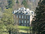 Upload another image | |
| Longformacus House, Dovecot | Longformacus | NT6956557384 | 55°48′32″N 2°29′14″W / 55.808762°N 2.487155°W / 55.808762; -2.487155 (Longformacus House, Dovecot) | Early to mid 18th century.[57] | 8345 | 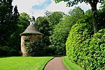 Upload another image | |
| St Mary's Church, Ladykirk | Ladykirk | NT8887647660 | 55°43′20″N 2°10′43″W / 55.722228°N 2.178654°W / 55.722228; -2.178654 (St Mary's Church, Ladykirk) | [58] | 8349 |  Upload another image | |
| West Lodge, Ladykirk House | Ladykirk | NT8747245457 | 55°42′09″N 2°12′03″W / 55.702399°N 2.200903°W / 55.702399; -2.200903 (West Lodge, Ladykirk House) | Dated 1799.[59] | 8351 |  Upload another image | |
| Spitalhaugh House | West Linton | 04/11/2010 | NT1627049662 | 55°43′59″N 3°20′05″W / 55.733139°N 3.334806°W / 55.733139; -3.334806 (Spitalhaugh House) | [60] | 8361 | Upload Photo |
| Tentyfoot Tower | Branxholme | NT4643911687 | 55°23′46″N 2°50′50″W / 55.396193°N 2.847192°W / 55.396193; -2.847192 (Tentyfoot Tower) | [61] | 8397 | Upload Photo | |
| Floors Castle | Kelso | NT7111034670 | 55°36′17″N 2°27′36″W / 55.604776°N 2.4601°W / 55.604776; -2.4601 (Floors Castle) | Built by William Adam, 1721-6, possibly incorporating earlier fabric, and remodelled by W H Playfair, 1837-1845.[62] | 10480 |  Upload another image | |
| Greenlaw Church | Greenlaw | NT7116246152 | 55°42′29″N 2°27′38″W / 55.707944°N 2.460484°W / 55.707944; -2.460484 (Greenlaw Church) | [63] | 10490 |  Upload another image | |
| Old Market Cross in Churchyard | Greenlaw | NT7115046146 | 55°42′28″N 2°27′38″W / 55.707889°N 2.460675°W / 55.707889; -2.460675 (Old Market Cross in Churchyard) | [64] | 10491 |  Upload another image | |
| Greenlaw Court House | Greenlaw, The Square | NT7113946064 | 55°42′26″N 2°27′39″W / 55.707152°N 2.460841°W / 55.707152; -2.460841 (Greenlaw Court House) | Built 1829, architect was John Cunningham.[65] | 10492 |  Upload another image | |
| Castle Inn | Greenlaw, The Square | NT7114345992 | 55°42′23″N 2°27′39″W / 55.706505°N 2.46077°W / 55.706505; -2.46077 (Castle Inn) | Early 19th century.[66] | 10493 | Upload Photo | |
| Paxton House | Paxton | NT9319751977 | 55°45′40″N 2°06′36″W / 55.761097°N 2.109975°W / 55.761097; -2.109975 (Paxton House) | [67] | 10506 | 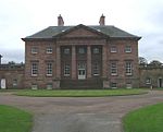 Upload another image | |
| Fogo Kirk | Fogo | NT7725749196 | 55°44′08″N 2°21′49″W / 55.73562°N 2.363747°W / 55.73562; -2.363747 (Fogo Kirk) | [68] | 10512 |  Upload another image | |
| Fogo Bridge | Fogo | NT7698149203 | 55°44′08″N 2°22′05″W / 55.735669°N 2.368143°W / 55.735669; -2.368143 (Fogo Bridge) | Single span round-arched bridge dated 1641 and rebuilt 1843.[69] | 10513 |  Upload another image | |
| Gifford Stones House | West Linton, Main Street | NT1500251814 | 55°45′08″N 3°21′21″W / 55.752201°N 3.355772°W / 55.752201; -3.355772 (Gifford Stones House) | Late 19th century with elaborately carved 17th century stone inset panels.[70] | 12888 | Upload Photo | |
| Glenmayne House | Galashiels | NT4984833737 | 55°35′41″N 2°47′51″W / 55.594663°N 2.797369°W / 55.594663; -2.797369 (Glenmayne House) | [71] | 12929 |  Upload another image | |
| Nether Road, Gala Fairydean Football Stadium | 55°36′23″N 2°47′03″W / 55.606367°N 2.784067°W / 55.606367; -2.784067 (Nether Road, Gala Fairydean Football Stadium) | 50711 |  Upload another image | ||||
| Stoneyhill House | Walkerburn, Galashiels Road | NT3629537267 | 55°37′29″N 3°00′48″W / 55.624789°N 3.013211°W / 55.624789; -3.013211 (Stoneyhill House) | [72] | 12930 | Upload Photo | |
| Scott-Douglas Mausoleum | Springwood, Kelso | NT7142233567 | 55°35′42″N 2°27′18″W / 55.594885°N 2.455033°W / 55.594885; -2.455033 (Scott-Douglas Mausoleum) | Neo-classical temple mausoleum by James Gillespie Graham, c. 1820 – c. 1825[73] | 12952 |  Upload another image | |
| Edgerston House | Jedburgh | NT6904011563 | 55°23′49″N 2°29′25″W / 55.39703°N 2.490365°W / 55.39703; -2.490365 (Edgerston House) | [74] | 13360 | Upload Photo | |
| Ferniehurst Castle | Jedburgh | NT6523517969 | 55°27′16″N 2°33′04″W / 55.454333°N 2.551239°W / 55.454333; -2.551239 (Ferniehurst Castle) | Late 16th century, considerably altered subsequently and restored 1883, 1938 and 1987-90.[75] | 13369 | 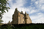 Upload another image | |
| Ferniehurst Castle, Visitor Centre (Former Chapel) | Jedburgh | NT6525518022 | 55°27′17″N 2°33′03″W / 55.454811°N 2.55093°W / 55.454811; -2.55093 (Ferniehurst Castle, Visitor Centre (Former Chapel)) | [76] | 13370 | 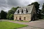 Upload another image | |
| Glenburn Hall | Jedburgh | NT6419220075 | 55°28′23″N 2°34′05″W / 55.47318°N 2.568002°W / 55.47318; -2.568002 (Glenburn Hall) | Built c. 1815[77] | 13371 | Upload Photo | |
| Leithen Lodge | Innerleithen | NT3208642789 | 55°40′26″N 3°04′53″W / 55.673826°N 3.081405°W / 55.673826; -3.081405 (Leithen Lodge) | Early 19th century, with later additions and alterations.[78] | 13475 | 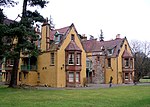 Upload another image | |
| Union Suspension Bridge | Hutton, Fishwick | NT9339151025 | 55°45′09″N 2°06′25″W / 55.752546°N 2.106861°W / 55.752546; -2.106861 (Union Suspension Bridge) | [79][note 4] | 13645 |  Upload another image | |
| Branxholme Castle | Branxholme | NT4644311667 | 55°23′46″N 2°50′50″W / 55.396013°N 2.847125°W / 55.396013; -2.847125 (Branxholme Castle) | [80] | 13686 |  Upload another image | |
| Swinton House, Dovecot | Swinton | NT8146346888 | 55°42′54″N 2°17′48″W / 55.715063°N 2.296611°W / 55.715063; -2.296611 (Swinton House, Dovecot) | Dated 1746 and repaired later 20th century.[81] | 13850 | Upload Photo | |
| Neidpath Castle | Peebles | NT2361840487 | 55°39′07″N 3°12′55″W / 55.651887°N 3.215374°W / 55.651887; -3.215374 (Neidpath Castle) | [82] | 13857 |  Upload another image | |
| Harden | Roberton | NT4493814885 | 55°25′29″N 2°52′17″W / 55.424759°N 2.87152°W / 55.424759; -2.87152 (Harden) | 17th century with later additions.[83] | 15089 | Upload Photo | |
| Railway Viaduct over the River Teviot | Roxburgh | NT7020030413 | 55°33′59″N 2°28′27″W / 55.566472°N 2.474081°W / 55.566472; -2.474081 (Railway Viaduct over the River Teviot) | [84] | 15097 | 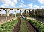 Upload another image | |
| Abbotsford | Melrose | NT5081534266 | 55°35′58″N 2°46′56″W / 55.599515°N 2.782121°W / 55.599515; -2.782121 (Abbotsford) | [85] | 15104 |  Upload another image | |
| Drygrange Old Bridge | Leaderfoot, Newstead | NT5753034668 | 55°36′14″N 2°40′32″W / 55.60376°N 2.675626°W / 55.60376; -2.675626 (Drygrange Old Bridge) | Late 18th century bridge crossing the River Tweed.[86] | 15106 |  Upload another image | |
| Mertoun House | St Boswells | NT6178931722 | 55°34′40″N 2°36′27″W / 55.577645°N 2.607624°W / 55.577645; -2.607624 (Mertoun House) | [87] | 15110 | 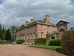 Upload another image | |
| Mertoun House, Dovecot | St Boswells | NT6201831894 | 55°34′45″N 2°36′14″W / 55.579208°N 2.604016°W / 55.579208; -2.604016 (Mertoun House, Dovecot) | Dated 1576.[88] | 15112 |  Upload another image | |
| Dryburgh Abbey memorials | Dryburgh, St Boswells | NT5915831703 | 55°34′38″N 2°38′58″W / 55.57726°N 2.649349°W / 55.57726; -2.649349 (Dryburgh Abbey memorials) | [89] | 15114 | 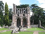 Upload another image | |
| Bemersyde House | Bemersyde | NT5921633328 | 55°35′31″N 2°38′55″W / 55.591865°N 2.64867°W / 55.591865; -2.64867 (Bemersyde House) | [90] | 15120 |  Upload another image | |
| Leaderfoot Viaduct | Leaderfoot, Newstead | NT5738534743 | 55°36′16″N 2°40′41″W / 55.604421°N 2.677939°W / 55.604421; -2.677939 (Leaderfoot Viaduct) | Former railway viaduct spanning the River Tweed, built 1865.[91] | 15145 |  Upload another image | |
| Sundial, Lamancha | West Linton | NT1995452238 | 55°45′25″N 3°16′37″W / 55.756854°N 3.277023°W / 55.756854; -3.277023 (Sundial, Lamancha) | Late 17th century.[92] | 15177 |  Upload another image | |
| The Haining | Selkirk | NT4689728028 | 55°32′35″N 2°50′35″W / 55.543058°N 2.84309°W / 55.543058; -2.84309 (The Haining) | [93] | 15190 |  Upload another image | |
| The Haining, Stables | Selkirk | NT4681028021 | 55°32′35″N 2°50′40″W / 55.542986°N 2.844467°W / 55.542986; -2.844467 (The Haining, Stables) | [94] | 15191 |  Upload another image | |
| Aikwood Tower | Selkirk | NT4200626042 | 55°31′29″N 2°55′13″W / 55.524658°N 2.920171°W / 55.524658; -2.920171 (Aikwood Tower) | Early 17th century tower.[95] | 15195 | 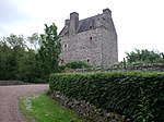 Upload another image | |
| Bowhill House | Selkirk | NT4258227810 | 55°32′26″N 2°54′41″W / 55.54061°N 2.911416°W / 55.54061; -2.911416 (Bowhill House) | [96] | 15196 |  Upload another image | |
| Neidpath Railway Viaduct | Peebles | NT2328340195 | 55°38′57″N 3°13′14″W / 55.649211°N 3.220615°W / 55.649211; -3.220615 (Neidpath Railway Viaduct) | Former railway viaduct crossing the River Tweed, opened 1864.[97] | 15206 |  Upload another image | |
| Newton Don | Stichill | NT7091137200 | 55°37′39″N 2°27′49″W / 55.627496°N 2.463526°W / 55.627496; -2.463526 (Newton Don) | [98] | 15220 | 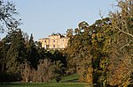 Upload another image | |
| Swinton House | Swinton | NT8182547086 | 55°43′01″N 2°17′27″W / 55.716855°N 2.290862°W / 55.716855; -2.290862 (Swinton House) | Dated 1800 with later additions and alterations.[99] | 15339 | Upload Photo | |
| Barns House, Stables | Peebles | NT2151039112 | 55°38′21″N 3°14′54″W / 55.639199°N 3.248471°W / 55.639199; -3.248471 (Barns House, Stables) | [100] | 15362 | Upload Photo | |
| Stobo Castle | Stobo, Peebles | NT1729836660 | 55°36′59″N 3°18′53″W / 55.616474°N 3.314627°W / 55.616474; -3.314627 (Stobo Castle) | [101] | 15379 |  Upload another image | |
| Polwarth Church | Polwarth | NT7499549492 | 55°44′17″N 2°23′59″W / 55.738167°N 2.399796°W / 55.738167; -2.399796 (Polwarth Church) | [102] | 15384 | 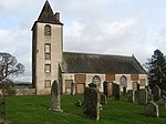 Upload another image | |
| Marchmont House | Greenlaw | NT7432248498 | 55°43′45″N 2°24′38″W / 55.729201°N 2.41042°W / 55.729201; -2.41042 (Marchmont House) | [103] | 15386 |  Upload another image | |
| Marchmont Estate, Dovecot | Greenlaw | NT7600149889 | 55°44′30″N 2°23′02″W / 55.741785°N 2.38381°W / 55.741785; -2.38381 (Marchmont Estate, Dovecot) | [104] | 15388 |  Upload another image | |
| Traquair House | Traquair | NT3307435480 | 55°36′30″N 3°03′50″W / 55.608302°N 3.063917°W / 55.608302; -3.063917 (Traquair House) | [105] | 15429 |  Upload another image | |
| Traquair House, Bear Gates and Avenue Head Cottages | Traquair | NT3262335159 | 55°36′19″N 3°04′16″W / 55.605356°N 3.070996°W / 55.605356; -3.070996 (Traquair House, Bear Gates and Avenue Head Cottages) | [106] | 15430 |  Upload another image | |
| Kailzie, Dovecote | Peebles | NT2818738633 | 55°38′09″N 3°08′32″W / 55.635929°N 3.142298°W / 55.635929; -3.142298 (Kailzie, Dovecote) | Dated 1698.[107] | 15439 | Upload Photo | |
| Lessudden House | St Boswells | NT5987431429 | 55°34′29″N 2°38′17″W / 55.574858°N 2.637953°W / 55.574858; -2.637953 (Lessudden House) | [108] | 17412 |  Upload another image | |
| Hoselaw Chapel | Kirk Yetholm | NT8016831758 | 55°34′45″N 2°18′58″W / 55.579067°N 2.316125°W / 55.579067; -2.316125 (Hoselaw Chapel) | [109] | 18799 | 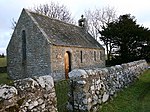 Upload another image | |
| Traquair House, Summerhouse | Traquair | NT3294235197 | 55°36′21″N 3°03′57″W / 55.605741°N 3.065943°W / 55.605741; -3.065943 (Traquair House, Summerhouse) | Dated 1834.[110] | 19391 |  Upload another image | |
| The Studio (former Bernat Klein Studio) | High Sunderland, Selkirk | NT4737631377 | 55°34′24″N 2°50′10″W / 55.573199°N 2.836139°W / 55.573199; -2.836139 (The Studio (former Bernat Klein Studio)) | Late Modernist building, 1972, designed by Peter Womersley.[111] | 19484 |  Upload another image | |
| Whim House, Court of Offices | West Linton | NT2140253578 | 55°46′09″N 3°15′16″W / 55.769129°N 3.254343°W / 55.769129; -3.254343 (Whim House, Court of Offices) | [112] | 19724 | Upload Photo | |
| Wedderlie House | Westruther | NT6394151535 | 55°45′21″N 2°34′34″W / 55.755823°N 2.576104°W / 55.755823; -2.576104 (Wedderlie House) | [113] | 19740 | 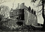 Upload another image | |
| The Glen | Traquair | NT2980233044 | 55°35′09″N 3°06′55″W / 55.585956°N 3.115224°W / 55.585956; -3.115224 (The Glen) | [114] | 19746 | 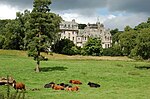 Upload another image | |
| Chester House | Eyemouth, Church Street | NT9450364241 | 55°52′17″N 2°05′22″W / 55.871305°N 2.089417°W / 55.871305; -2.089417 (Chester House) | Mid 18th century.[115] | 31128 | Upload Photo | |
| Gunsgreen House | Eyemouth | NT9474564368 | 55°52′21″N 2°05′08″W / 55.872449°N 2.085552°W / 55.872449; -2.085552 (Gunsgreen House) | [116] | 31133 |  Upload another image | |
| Old Gala House | Galashiels, Scott Crescent | NT4916535897 | 55°36′50″N 2°48′31″W / 55.613998°N 2.808605°W / 55.613998; -2.808605 (Old Gala House) | [117] | 31973 |  Upload another image | |
| Kingsknowes | Galashiels, Selkirk Road | NT5074134737 | 55°36′13″N 2°47′00″W / 55.603739°N 2.78338°W / 55.603739; -2.78338 (Kingsknowes) | [118] | 31999 | Upload Photo | |
| Woodlands | Galashiels, Windyknowe Road | NT4848236520 | 55°37′10″N 2°49′10″W / 55.619524°N 2.819564°W / 55.619524; -2.819564 (Woodlands) | [119] | 32002 | Upload Photo | |
| Tower Mill | Hawick, Kirkstile | NT5020014429 | 55°25′16″N 2°47′18″W / 55.421226°N 2.788309°W / 55.421226; -2.788309 (Tower Mill) | [120] | 34619 | 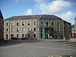 Upload another image | |
| Hawick Town Hall | Hawick, High Street | NT5034114559 | 55°25′21″N 2°47′12″W / 55.422611°N 2.786667°W / 55.422611; -2.786667 (Hawick Town Hall) | [121] | 34634 | 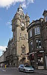 Upload another image | |
| Equestrian Statue | Hawick, High Street | NT5042814790 | 55°25′28″N 2°47′05″W / 55.424492°N 2.784772°W / 55.424492; -2.784772 (Equestrian Statue) | [122] | 34645 |  Upload another image | |
| Newgate | Jedburgh, Abbey Place | NT6499420531 | 55°28′38″N 2°33′19″W / 55.477336°N 2.555373°W / 55.477336; -2.555373 (Newgate) | [123] | 35457 | 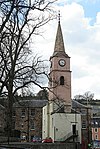 Upload another image | |
| Canongate Bridge | Jedburgh | NT6526020597 | 55°28′41″N 2°33′04″W / 55.477948°N 2.551174°W / 55.477948; -2.551174 (Canongate Bridge) | 16th century.[124] | 35471 | 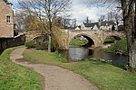 Upload another image | |
| Jedburgh Castle Old Jail | Jedburgh, Castlegate | NT6476120184 | 55°28′27″N 2°33′32″W / 55.474201°N 2.559015°W / 55.474201; -2.559015 (Jedburgh Castle Old Jail) | [125] | 35482 | 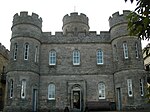 Upload another image | |
| 3-5 (Odd Nos) Exchange Street | Jedburgh | NT6498620594 | 55°28′40″N 2°33′20″W / 55.477901°N 2.555508°W / 55.477901; -2.555508 (3-5 (Odd Nos) Exchange Street) | [126] | 35520 |  Upload another image | |
| 11 Exchange Street | Jedburgh | NT6496420612 | 55°28′41″N 2°33′21″W / 55.478061°N 2.555858°W / 55.478061; -2.555858 (11 Exchange Street) | [127] | 35522 |  Upload another image | |
| Jedburgh Old Parish Church | Jedburgh, Newcastle Road | NT6508420235 | 55°28′29″N 2°33′14″W / 55.474683°N 2.553912°W / 55.474683; -2.553912 (Jedburgh Old Parish Church) | [128] | 35581 | 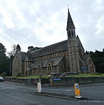 Upload another image | |
| St John's Episcopal Church | Jedburgh, The Pleasance | NT6509620983 | 55°28′53″N 2°33′14″W / 55.481404°N 2.553817°W / 55.481404; -2.553817 (St John's Episcopal Church) | [129] | 35589 |  Upload another image | |
| Queen Mary's House | Jedburgh, Queen Street | NT6516220674 | 55°28′43″N 2°33′10″W / 55.478633°N 2.552734°W / 55.478633; -2.552734 (Queen Mary's House) | Late 16th century house.[130] | 35591 |  Upload another image | |
| Kelso Old Parish Church | Kelso, Abbey Row | NT7293033909 | 55°35′53″N 2°25′52″W / 55.598044°N 2.431139°W / 55.598044; -2.431139 (Kelso Old Parish Church) | [131] | 35696 |  Upload another image | |
| Ednam House Hotel | Kelso, Bridge Street | NT7271733836 | 55°35′51″N 2°26′04″W / 55.597376°N 2.434512°W / 55.597376; -2.434512 (Ednam House Hotel) | [132] | 35716 |  Upload another image | |
| Bridge-End Cottage | Kelso, Bridge Street | NT7282333669 | 55°35′45″N 2°25′58″W / 55.595882°N 2.432813°W / 55.595882; -2.432813 (Bridge-End Cottage) | [133] | 35724 | Upload Photo | |
| Kelso Bridge | Kelso | NT7279133614 | 55°35′43″N 2°26′00″W / 55.595386°N 2.433315°W / 55.595386; -2.433315 (Kelso Bridge) | Built 1800-1803 to replace a bridge destroyed in a flood in 1797.[134] | 35764 |  Upload another image | |
| St John's Edenside and Ednam Church Of Scotland | Kelso, Roxburgh Street | NT7257234201 | 55°36′02″N 2°26′13″W / 55.600647°N 2.436849°W / 55.600647; -2.436849 (St John's Edenside and Ednam Church Of Scotland) | [135] | 35800 |  Upload another image | |
| Walton Hall | Kelso, Roxburgh Street | NT7233434309 | 55°36′06″N 2°26′26″W / 55.601604°N 2.440637°W / 55.601604; -2.440637 (Walton Hall) | [136] | 35805 | Upload Photo | |
| Walton Hall, entrance gateways and wall | Kelso, Roxburgh Street | NT7233434309 | 55°36′06″N 2°26′26″W / 55.601604°N 2.440637°W / 55.601604; -2.440637 (Walton Hall, entrance gateways and wall) | [137] | 35806 | Upload Photo | |
| Floors Castle, gates and gate lodges | Kelso | NT7219934419 | 55°36′09″N 2°26′34″W / 55.602585°N 2.44279°W / 55.602585; -2.44279 (Floors Castle, gates and gate lodges) | [138] | 35811 |  Upload another image | |
| Springwood Park, Gateway and Gates | Kelso | NT7265033461 | 55°35′38″N 2°26′08″W / 55.594003°N 2.435537°W / 55.594003; -2.435537 (Springwood Park, Gateway and Gates) | [139] | 35826 | Upload Photo | |
| Teviot Bridge | Kelso | NT7198433547 | 55°35′41″N 2°26′46″W / 55.594738°N 2.446114°W / 55.594738; -2.446114 (Teviot Bridge) | [140] | 35847 |  Upload another image | |
| Lauder Church | Lauder, East High Street | NT5309347533 | 55°43′08″N 2°44′54″W / 55.718936°N 2.748244°W / 55.718936; -2.748244 (Lauder Church) | [141] | 37200 |  Upload another image | |
| Darnick Tower | Darnick, Tower Road | NT5320234375 | 55°36′03″N 2°44′39″W / 55.60073°N 2.744262°W / 55.60073; -2.744262 (Darnick Tower) | [142] | 37756 |  Upload another image | |
| Market Cross | Melrose, Market Square | NT5476833973 | 55°35′50″N 2°43′10″W / 55.597266°N 2.719345°W / 55.597266; -2.719345 (Market Cross) | [143] | 37794 |  Upload another image | |
| Melrose railway station | Melrose, Palma Place | NT5468333912 | 55°35′48″N 2°43′14″W / 55.59671°N 2.720684°W / 55.59671; -2.720684 (Melrose railway station) | Opened 1849.[144] | 37803 | 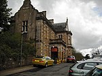 Upload another image | |
| St Helen's | Melrose, Waverley Road | NT5365734721 | 55°36′14″N 2°44′14″W / 55.603882°N 2.7371°W / 55.603882; -2.7371 (St Helen's) | [145] | 37811 | Upload Photo | |
| Chambers Institution | Peebles, High Street | NT2525940443 | 55°39′06″N 3°11′21″W / 55.651747°N 3.189291°W / 55.651747; -3.189291 (Chambers Institution) | [146] | 39180 |  Upload another image | |
| Town House | Peebles, High Street | NT2522640419 | 55°39′05″N 3°11′23″W / 55.651526°N 3.189808°W / 55.651526; -3.189808 (Town House) | [147] | 39188 | Upload Photo | |
| Tweed Bridge | Peebles | NT2504340305 | 55°39′02″N 3°11′34″W / 55.650474°N 3.192685°W / 55.650474; -3.192685 (Tweed Bridge) | [148] | 39278 | 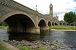 Upload another image | |
| Town House, Old Sheriff Court | Selkirk, Market Place | NT4702628477 | 55°32′50″N 2°50′28″W / 55.547106°N 2.841132°W / 55.547106; -2.841132 (Town House, Old Sheriff Court) | [149] | 40569 |  Upload another image | |
| Ettrick Mill | Selkirk, Dunsdale Road | NT4716829288 | 55°33′16″N 2°50′21″W / 55.554408°N 2.839037°W / 55.554408; -2.839037 (Ettrick Mill) | Mid 19th century woollen spinning and tweed manufacturing complex.[150] | 40578 |  Upload another image | |
| War Memorial | Selkirk, Ettrick Terrace | NT4691728538 | 55°32′52″N 2°50′34″W / 55.547642°N 2.842871°W / 55.547642; -2.842871 (War Memorial) | [151] | 40581 |  Upload another image | |
| Manderston, Boat House and Gateway | Duns | NT8107854221 | 55°46′51″N 2°18′12″W / 55.780934°N 2.30325°W / 55.780934; -2.30325 (Manderston, Boat House and Gateway) | Swiss chalet style boat house, built 1894 by John Kinross.[152] | 42505 | Upload Photo | |
| Manderston, Buxley, Dairy Court | Duns | NT8095654774 | 55°47′09″N 2°18′19″W / 55.785898°N 2.305234°W / 55.785898; -2.305234 (Manderston, Buxley, Dairy Court) | [153] | 42508 |  Upload another image | |
| Manderston, Buxley, Dairy Tower with Unicorn Stair | Duns | NT8096854773 | 55°47′09″N 2°18′18″W / 55.785889°N 2.305042°W / 55.785889; -2.305042 (Manderston, Buxley, Dairy Tower with Unicorn Stair) | [154] | 42510 | Upload another image | |
| Manderston, Buxley, Engineer's House | Duns | NT8090954814 | 55°47′11″N 2°18′22″W / 55.786255°N 2.305986°W / 55.786255; -2.305986 (Manderston, Buxley, Engineer's House) | [155] | 42511 | Upload Photo | |
| Manderston, Buxley, Fire Station and Engine House | Duns | NT8093954828 | 55°47′11″N 2°18′20″W / 55.786382°N 2.305508°W / 55.786382; -2.305508 (Manderston, Buxley, Fire Station and Engine House) | [156] | 42514 | Upload Photo | |
| Manderston, Buxley, Head Gardener's House | Duns | NT8090154784 | 55°47′10″N 2°18′22″W / 55.785986°N 2.306111°W / 55.785986; -2.306111 (Manderston, Buxley, Head Gardener's House) | [157] | 42516 | Upload Photo | |
| Manderston, Pheasantry Wood, Gamekeeper's Cottage with Dovecot | Duns | NT8155354434 | 55°46′58″N 2°17′44″W / 55.782866°N 2.295691°W / 55.782866; -2.295691 (Manderston, Pheasantry Wood, Gamekeeper's Cottage with Dovecot) | [158] | 42528 | Upload Photo | |
| Manderston, Terraces to south and east, including Ram's Horn Stair, urns, Mercury Statue and Griffin Gate | Duns | NT8110554354 | 55°46′56″N 2°18′10″W / 55.78213°N 2.302828°W / 55.78213; -2.302828 (Manderston, Terraces to south and east, including Ram's Horn Stair, urns, Mercury Statue and Griffin Gate) | [159] | 42534 | Upload Photo | |
| Wedderburn Castle | Duns | NT8083852854 | 55°46′07″N 2°18′25″W / 55.768642°N 2.306979°W / 55.768642; -2.306979 (Wedderburn Castle) | [160] | 42543 |  Upload another image | |
| Nisbet House, Stable and Coach House | Duns | NT7953051245 | 55°45′15″N 2°19′40″W / 55.754132°N 2.327705°W / 55.754132; -2.327705 (Nisbet House, Stable and Coach House) | [161] | 44511 |  Upload another image | |
| Ayton Parish Church | Ayton | NT9272960866 | 55°50′27″N 2°07′04″W / 55.840957°N 2.117674°W / 55.840957; -2.117674 (Ayton Parish Church) | [162] | 46451 |  Upload another image | |
| Paxton House Estate, The Dower House (former Factor's House) | Paxton | NT9278552294 | 55°45′50″N 2°07′00″W / 55.763939°N 2.116549°W / 55.763939; -2.116549 (Paxton House Estate, The Dower House (former Factor's House)) | [163] | 47697 | Upload Photo | |
| Stoneyhill Cottage (former Stoneyhill Lodge) | Walkerburn, Galashiels Road | NT3621537151 | 55°37′25″N 3°00′52″W / 55.623736°N 3.014455°W / 55.623736; -3.014455 (Stoneyhill Cottage (former Stoneyhill Lodge)) | [164] | 49134 |  Upload another image | |
| Sunnybrae Lodge | Walkerburn, Galashiels Road | NT3617737142 | 55°37′25″N 3°00′54″W / 55.623651°N 3.015056°W / 55.623651; -3.015056 (Sunnybrae Lodge) | [165] | 49136 | Upload Photo | |
| The Glen, Lion Gateway, garden features and terraces | Traquair | NT2975833026 | 55°35′09″N 3°06′57″W / 55.585788°N 3.115917°W / 55.585788; -3.115917 (The Glen, Lion Gateway, garden features and terraces) | [166] | 49386 | Upload Photo | |
| The Glen, Stable Courtyard | Traquair | NT2978333082 | 55°35′11″N 3°06′56″W / 55.586295°N 3.115535°W / 55.586295; -3.115535 (The Glen, Stable Courtyard) | [167] | 49393 | Upload Photo | |
| The Glen, The Temple | Traquair | NT2965732412 | 55°34′49″N 3°07′03″W / 55.580258°N 3.117362°W / 55.580258; -3.117362 (The Glen, The Temple) | [168] | 49395 | Upload Photo | |
| High Sunderland | Selkirk | NT2965732412 | 55°34′49″N 3°07′03″W / 55.580258°N 3.117362°W / 55.580258; -3.117362 (High Sunderland) | [169] | 50862 |  Upload another image | |
| Kelso Racecourse, Grandstand | Kelso | NT7258935534 | 55°36′45″N 2°26′12″W / 55.612625°N 2.436712°W / 55.612625; -2.436712 (Kelso Racecourse, Grandstand) | [170] | 51742 |  Upload another image |
See also
Notes
- ^ Sometimes known as OSGB36, the grid reference (where provided) is based on the British national grid reference system used by the Ordnance Survey.
• "Guide to National Grid". Ordnance Survey. Retrieved 12 December 2007.
• "Get-a-map". Ordnance Survey. Retrieved 17 December 2007. - ^ Historic Environment Scotland assign a unique alphanumeric identifier to each designated site in Scotland, for listed buildings this always begins with "LB", for example "LB12345".
- ^ Also in England, listed at grade II*, Historic England. "Details from listed building database (1153712)". National Heritage List for England. Retrieved 28 September 2011.
- ^ Also in England, listed at grade I, Historic England. "Details from listed building database (1042214)". National Heritage List for England. Retrieved 28 September 2011.
References
- ^ Guide to the Protection of Scotland's Listed Buildings (PDF). Historic Scotland. 2009. p. 4. ISBN 978-1-84917-013-0. Retrieved 5 May 2010.
- ^ "What is Listing?". Historic Scotland. Retrieved 5 May 2010.
- ^ a b Scottish Historic Environment Policy (PDF). Historic Scotland. October 2008. pp. 24–25. ISBN 978-1-84917-002-4. Retrieved 5 May 2010.
- ^ Guide to the Protection of Scotland's Listed Buildings, p. 17.
- ^ Historic Environment Scotland. "Torwoodlee (LB135)".
- ^ Historic Environment Scotland. "Cranshaws Church (Church Of Scotland) Including Graveyard, Gatepiers And Gates (LB201)".
- ^ Historic Environment Scotland. "Old Ancrum Bridge (LB224)".
- ^ Historic Environment Scotland. "Parish Church Of St Cuthbert & Churchyard, Channelkirk (LB1893)".
- ^ Historic Environment Scotland. "Yair House (LB1899)".
- ^ Historic Environment Scotland. "Yair Bridge (LB1901)".
- ^ Historic Environment Scotland. "Ashiesteel (LB1902)".
- ^ Historic Environment Scotland. "Ashiesteel Bridge (LB1903)".
- ^ Historic Environment Scotland. "Peel Hospital (LB1904)".
- ^ Historic Environment Scotland. "Bowden Church And Graveyard (LB1920)".
- ^ Historic Environment Scotland. "The Retreat Including The Retreat Cottage, Walled Garden, Outbuilding And Sundial (LB1971)".
- ^ Historic Environment Scotland. "Ayton Castle Including Service Courtyard, Courtyard Walls And Garden Rampart Walls (LB1987)".
- ^ Historic Environment Scotland. "Ayton Castle, Dovecot (LB1989)".
- ^ Historic Environment Scotland. "BROUGHTON PLACE INCLUDING SUMMERHOUSE, TENNIS COURT, WALLED GARDEN, GATEPIERS AND STABLEBLOCK (LB2031)". Retrieved 21 August 2017.
- ^ Historic Environment Scotland. "Portmore (LB2037)".
- ^ Historic Environment Scotland. "Westgate Hall (LB2052)".
- ^ Historic Environment Scotland. "Crailing House (LB2080)".
- ^ Historic Environment Scotland. "Cowdenknowes (LB2120)".
- ^ Historic Environment Scotland. "Mellerstain House (LB2123)".
- ^ Historic Environment Scotland. "Stables And Cottage Block, Mellerstain (LB2124)".
- ^ Historic Environment Scotland. "Edrom, Parish Church With Graveyeard And Monuments (LB2127)".
- ^ Historic Environment Scotland. "Nisbet House, Including Walled Garden And Gardener's Cottage, Vault (LB2131)".
- ^ Historic Environment Scotland. "Nisbet Dovecot (LB2132)".
- ^ Historic Environment Scotland. "Kalemouth Suspension Bridge, Over River Teviot (LB3849)".
- ^ Historic Environment Scotland. "Wedderburn Castle, Lion Gate And Boundary Walls (LB4029)".
- ^ Historic Environment Scotland. "Manderston Including Service Court And Motor House (LB4033)".
- ^ Historic Environment Scotland. "Manderston, Stables (LB4034)".
- ^ Historic Environment Scotland. "Old Manor House (Sparrow Castle) (LB4046)".
- ^ Historic Environment Scotland. "Market Cross Cockburnspath (LB4047)".
- ^ Historic Environment Scotland. "Pease Bridge (LB4054)".
- ^ Historic Environment Scotland. "Coldingham Priory Church including former hearse house and store, graveyard, boundary walls, gatepiers and gates and excluding scheduled monument SM383, Coldingham (LB4059)".
- ^ Historic Environment Scotland. "Lennel House (LB4068)".
- ^ Historic Environment Scotland. "The Hirsel (LB4069)".
- ^ Historic Environment Scotland. "Coldstream Bridge (that part in Scotland) over the Tweed (LB4075)".
- ^ Historic Environment Scotland. "Cranshaws Castle Including Sundial, Covered Well And Garden Walls (LB4093)".
- ^ Historic Environment Scotland. "Coldingham, School Road, Market Cross (LB4094)".
- ^ Historic Environment Scotland. "Renton House including Pavilions, Sundial, Quadrant Walls And Boundary Walls (LB4105)".
- ^ Historic Environment Scotland. "Duns Castle, With Screen Walls And Sundial (LB4108)".
- ^ Historic Environment Scotland. "Bughtrig House (LB4114)".
- ^ Historic Environment Scotland. "Kames House Including Cobbled Courtyard (LB4115)".
- ^ Historic Environment Scotland. "Preston Bridge (LB4120)".
- ^ Historic Environment Scotland. "Ninewells Dovecot (LB4124)".
- ^ Historic Environment Scotland. "Cockburnspath Church And Graveyard (LB4129)".
- ^ Historic Environment Scotland. "Chesters House (LB4174)".
- ^ Historic Environment Scotland. "Dovecot, Knowesouth (LB4182)".
- ^ Historic Environment Scotland. "Chirnside, Chirnside Primary School Including Playsheds, Boundary Walls, Quadrant Walls, Gates And Gatepiers (LB6620)".
- ^ Historic Environment Scotland. "Kirkhope Tower (LB6720)".
- ^ Historic Environment Scotland. "Greenlaw, Market Cross (LB6823)".
- ^ Historic Environment Scotland. "Thirlestane Castle (LB8203)".
- ^ Historic Environment Scotland. "Walkerburn, The Kirna (LB8323)".
- ^ Historic Environment Scotland. "Walkerburn, Prefabricated Cast - Iron Urinal (LB8326)".
- ^ Historic Environment Scotland. "Longformacus House including Ancillary Structures, Courtyard Gatepiers, Quadrant Walls, Railings, Gatepiers And Gates (LB8344)".
- ^ Historic Environment Scotland. "Longformacus House, Dovecot (LB8345)".
- ^ Historic Environment Scotland. "St Mary's Church Ladykirk (LB8349)".
- ^ Historic Environment Scotland. "West Lodge Ladykirk (LB8351)".
- ^ Historic Environment Scotland. "SPITALHAUGH HOUSE INCLUDING STABLE AND BRIDGELB8361 (LB8361)". Retrieved 21 August 2017.
- ^ Historic Environment Scotland. "Tentyfoot Tower (LB8397)".
- ^ Historic Environment Scotland. "Floors Castle (LB10480)".
- ^ Historic Environment Scotland. "Greenlaw Church (LB10490)".
- ^ Historic Environment Scotland. "Old Market Cross In Churchyard (LB10491)".
- ^ Historic Environment Scotland. "Court House Greenlaw (LB10492)".
- ^ Historic Environment Scotland. "Castle Inn And Supporting Coach House Wings Forming Courtyard (LB10493)".
- ^ Historic Environment Scotland. "Paxton House Estate, Paxton House (LB10506)".
- ^ Historic Environment Scotland. "Fogo Kirk, Church of Scotland, Including Inner And Outer Graveyards, Boundary Walls And Lych Gate (LB10512)".
- ^ Historic Environment Scotland. "Fogo Bridge (LB10513)".
- ^ Historic Environment Scotland. "West Linton, Main Street, Gifford Stones House (LB12888)".
- ^ Historic Environment Scotland. "Glenmayne House,Near Galashiels (LB12929)".
- ^ Historic Environment Scotland. "Walkerburn, Galashiels Road, Stoneyhill House, Stables And Boundary Walls (LB12930)".
- ^ Historic Environment Scotland. "Springwood Estate (Springwood Caravan Park), Scott-Douglas Mausoleum (LB12952)".
- ^ Historic Environment Scotland. "Edgerston House With Gatepiers, Terraces And Wall Garden, Birdpool, And Entrance Gates (LB13360)".
- ^ Historic Environment Scotland. "Ferniehurst Castle With Arched Gateway, Garden Walls And Outbuildings (LB13369)".
- ^ Historic Environment Scotland. "Ferniehurst Castle Visitor Centre (Former Chapel) (LB13370)".
- ^ Historic Environment Scotland. "Glenburn Hall With Walled Garden, Outbuildings, Gatepiers And Railings (LB13371)".
- ^ Historic Environment Scotland. "Leithen Lodge With Lochend Arch, Outbuildings And Sundial (LB13475)".
- ^ Historic Environment Scotland. "Union Suspension Bridge (that part in Scotland) (LB13645)".
- ^ Historic Environment Scotland. "Branxholme Castle (LB13686)".
- ^ Historic Environment Scotland. "Swinton House, Dovecot (LB13850)".
- ^ Historic Environment Scotland. "Neidpath Castle Including Courtyard Buildings, Gateway, Former Walled Garden And Boundary Wall (LB13857)".
- ^ Historic Environment Scotland. "Harden (LB15089)".
- ^ Historic Environment Scotland. "Railway Viaduct, Roxburgh (LB15097)".
- ^ {Historic Environment Scotland. "Abbotsford Including House, Walled Gardens And Courtyards, Conservatory, Bothies, Game Larder, Ice House, Terraces, Gate Lodge, Boundary Walls, Gardener's Cottage, Stable Block, Garden Statuary And All Other Ancillary Structures (LB15104)".
- ^ Historic Environment Scotland. "Drygrange Bridge (LB15106)".
- ^ Historic Environment Scotland. "Mertoun House (LB15110)".
- ^ Historic Environment Scotland. "Dovecote, Mertoun (LB15112)".
- ^ Historic Environment Scotland. "Tomb of Sir Walter Scott, King James obelisk, headstone of Field Marshall Earl Haig and memorials... (LB15114)".
- ^ Historic Environment Scotland. "Bemersyde House (LB15120)".
- ^ Historic Environment Scotland. "Leaderfoot Viaduct (LB15145)".
- ^ Historic Environment Scotland. "Sundial, Lamancha (LB15177)".
- ^ Historic Environment Scotland. "The Haining, Including Railed Screen Wall And Terrace Statues (LB15190)".
- ^ Historic Environment Scotland. "The Stables, Haining (LB15191)".
- ^ Historic Environment Scotland. "Aikwood Tower (LB15195)".
- ^ Historic Environment Scotland. "Bowhill (LB15196)".
- ^ Historic Environment Scotland. "Neidpath Railway Viaduct (Near Neidpath Castle) (LB15206)".
- ^ Historic Environment Scotland. "Newton Don (LB15220)".
- ^ Historic Environment Scotland. "Swinton House (LB15339)".
- ^ Historic Environment Scotland. "Barns Stables (LB15362)".
- ^ Historic Environment Scotland. "Stobo Castle (LB15379)".
- ^ Historic Environment Scotland. "Polwarth Church, Church Of Scotland, Including Graveyard, Boundary Walls And Gates (LB15384)".
- ^ Historic Environment Scotland. "Marchmont Estate, Marchmont House Including Garden Walls, Stairs And Sundial (LB15386)".
- ^ Historic Environment Scotland. "Marchmont Estate, Dovecot (LB15388)".
- ^ Historic Environment Scotland. "Traquair House Including Wings, Terraces, Pavilions, Courtyard Screen Walls, Gatepiers, Railings And Gates (LB15429)".
- ^ Historic Environment Scotland. "Traquair House Policies, Bear Gates And Avenue Head Cottages (4 Dwellings) (LB15430)".
- ^ Historic Environment Scotland. "Kailzie, Dovecote (LB15439)".
- ^ Historic Environment Scotland. "Lessudden House (LB17412)".
- ^ Historic Environment Scotland. "Hoselaw Chapel (Church Of Scotland) Including Boundary Walls And Gate (LB18799)".
- ^ Historic Environment Scotland. "Traquair House Policies, Summerhouse (LB19391)".
- ^ Historic Environment Scotland. "The Studio (Former Bernat Klein Studio) High Sunderland (LB19484)".
- ^ Historic Environment Scotland. "Court Of Offices, Whim House (LB19724)".
- ^ Historic Environment Scotland. "Wedderlie House (LB19740)".
- ^ Historic Environment Scotland. "The Glen, House And Service Wing (LB19746)".
- ^ Historic Environment Scotland. "11 Church Street, Chester House (LB31128)".
- ^ Historic Environment Scotland. "Gunsgreen House And Terrace Retaining Wall. (Eyemouth Golf Club And Border Sailing Club) (LB31133)".
- ^ Historic Environment Scotland. "Old Gala House (LB31973)".
- ^ Historic Environment Scotland. "Selkirk Road, Kingsknowes, House And Conservatory (LB31999)".
- ^ Historic Environment Scotland. "Windyknowe Road, Woodlands (LB32002)".
- ^ Historic Environment Scotland. "Kirkstile, Former Tower Mill (LB34619)".
- ^ Historic Environment Scotland. "34-44 HIGH STREET (EVEN NUMBERS), HAWICK TOWN HALL (LB34634)". Retrieved 22 August 2017.
- ^ Historic Environment Scotland. "High Street, The Horse (LB34645)".
- ^ Historic Environment Scotland. "Abbey Place, Newgate With Attached Wall, External Stair And Railings (LB35457)".
- ^ Historic Environment Scotland. "Canongate Bridge (LB35471)".
- ^ Historic Environment Scotland. "Castlegate, Jedburgh Castle Old Jail With Exercise Yard Walls, Fortifications, Portcullis Gates, Entrance Gates And Outer Embankment Wall (LB35482)".
- ^ Historic Environment Scotland. "3-5 (Odd Nos) Exchange Street (LB35520)".
- ^ Historic Environment Scotland. "11 Exchange Street (LB35522)".
- ^ Historic Environment Scotland. "Newcastle Road (And Oxnam Road), Old Parish Church With Gatepiers And Boundary Wall, (Church Of Scotland) (LB35581)".
- ^ Historic Environment Scotland. "Pleasance, St John's Episcopal Church With Lych Gate And Boundary Wall (LB35589)".
- ^ Historic Environment Scotland. "Queen Street, Queen Mary's House With Outbuildings, Boundary Wall And Railings (LB35591)".
- ^ Historic Environment Scotland. "Abbey Row Kelso Old Parish Church (LB35696)".
- ^ Historic Environment Scotland. "Bridge Street, Ednam House Hotel (LB35716)".
- ^ Historic Environment Scotland. "Bridge Street Bridge-End Cottage (LB35724)".
- ^ Historic Environment Scotland. "Kelso Bridge (LB35764)".
- ^ Historic Environment Scotland. "Roxburgh Street St John's Edenside And Ednam Church Of Scotland (LB35800)".
- ^ Historic Environment Scotland. "Roxburgh Street Walton Hall, And Stable Wing (LB35805)".
- ^ Historic Environment Scotland. "Roxburgh Street Walton Hall, Entrance Gateways And Wall (LB35806)".
- ^ Historic Environment Scotland. "Roxburgh Street Floors Castle Gates And Gate Lodges (LB35811)".
- ^ Historic Environment Scotland. "Springwood Park, Gateway And Gates (LB35826)".
- ^ Historic Environment Scotland. "Teviot Bridge (LB35847)".
- ^ Historic Environment Scotland. "East High Street, Lauder Church (Church Of Scotland), Including Entrance Gates And Churchyard Wall (LB37200)".
- ^ Historic Environment Scotland. "Darnick Village Tower Road Darnick Tower (LB37756)".
- ^ Historic Environment Scotland. "Market Square, Market Cross (LB37794)".
- ^ Historic Environment Scotland. "Melrose Railway Station (LB37803)".
- ^ Historic Environment Scotland. "Waverley Road, St Helen's (LB37811)".
- ^ Historic Environment Scotland. "High Street, Chambers Institution (LB39180)".
- ^ Historic Environment Scotland. "High Street, Town House (LB39188)".
- ^ Historic Environment Scotland. "Tweed Bridge (LB39278)".
- ^ Historic Environment Scotland. "Market Place, Town House, Old Sheriff Court And Boundary Walls (LB40569)".
- ^ Historic Environment Scotland. "Dunsdale Road, Ettrick Mill (LB40578)".
- ^ Historic Environment Scotland. "Ettrick Terrace, War Memorial (LB40581)".
- ^ Historic Environment Scotland. "Manderston, Boat House And Gateway (LB42505)".
- ^ Historic Environment Scotland. "Manderston, Buxley, Dairy Court (LB42508)".
- ^ Historic Environment Scotland. "Manderston, Buxley, Dairy Tower With Unicorn Stair (LB42510)".
- ^ Historic Environment Scotland. "Manderston, Buxley, Engineer's House With Gatepiers And Garden Walls (LB42511)".
- ^ Historic Environment Scotland. "Manderston, Buxley, Fire Station And Engine House With Stalk And Gatepiers (LB42514)".
- ^ {{HEScotland|fewer-links=yes|num=LB42516|desc=Manderston, Buxley, Head Gardener's House With Outbuildings, Boundary Walls And Gateways}
- ^ Historic Environment Scotland. "Manderston, Pheasantry Wood, Gamekeeper's Cottage With Dovecot (LB42528)".
- ^ Historic Environment Scotland. "Manderston, Terraces To South And East, Including Ram's Horn Stair, Urns, Mercury Statue And Griffin Gate (LB42534)".
- ^ Historic Environment Scotland. "Wedderburn Castle (LB42543)".
- ^ Historic Environment Scotland. "Nisbet House, Stable And Coach House (LB44511)".
- ^ Historic Environment Scotland. "Ayton Parish Church, Church Of Scotland, Including Boundary Walls, Railings, Gatepiers, Gates And War Memorial (LB46451)".
- ^ Historic Environment Scotland. "Paxton House Estate, The Dower House (Former Factor's House) (LB47697)".
- ^ Historic Environment Scotland. "Walkerburn, Galashiels Road, Stoneyhill Cottage (Former Stoneyhill Lodge) Including Boundary Wall And Gatepier (LB49134)".
- ^ Historic Environment Scotland. "Walkerburn, Galashiels Road, Sunnybrae Lodge Including Gatepiers, Stables And Boundary Walls (LB49136)".
- ^ Historic Environment Scotland. "The Glen, Lion Gateway, Garden Features And Terraces (LB49386)".
- ^ Historic Environment Scotland. "The Glen, Stable Courtyard (LB49393)".
- ^ Historic Environment Scotland. "The Glen, The Temple (LB49395)".
- ^ Historic Environment Scotland. "High Sunderland (LB50862)".
- ^ Historic Environment Scotland. "Kelso Racecourse, Grandstand (LB51742)".
External links
![]() Media related to Category A listed buildings in the Scottish Borders at Wikimedia Commons
Media related to Category A listed buildings in the Scottish Borders at Wikimedia Commons
- v
- t
- e
- City of Aberdeen
- Aberdeenshire
- Angus
- Argyll and Bute
- Clackmannanshire
- Dumfries and Galloway
- City of Dundee
- East Ayrshire
- East Dunbartonshire
- East Lothian
- East Renfrewshire
- City of Edinburgh
- Falkirk
- Fife
- City of Glasgow
- Highland
- Inverclyde
- Midlothian
- Moray
- North Ayrshire
- North Lanarkshire
- Orkney
- Perth and Kinross
- Renfrewshire
- Scottish Borders
- Shetland
- South Ayrshire
- South Lanarkshire
- Stirling
- West Dunbartonshire
- West Lothian
- Western Isles (na h-Eileanan Siar)


