Méricourt, Pas-de-Calais
Commune in Hauts-de-France, France

Coat of arms
Location of Méricourt

(2020–2026) Bernard Baude[1]
1
(2021)[2]
62570 /62680
(avg. 55 m or 180 ft)
Méricourt (French pronunciation: [meʁikuʁ]) is a commune in the Pas-de-Calais department in the Hauts-de-France region of France.[3]
Geography
Méricourt is a former coal mining town, nowadays a farming and light industrial town, 3 miles (4.8 km) southeast of Lens, at the junction of the D33, D40 and the D262 roads. The commune is part of the canton of Avion.
History
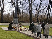
The history of the region remains marked by the Courrières mine disaster, which left 1,099 dead on 10 March 1906. The communes affected were Méricourt, Billy-Montigny, Noyelles-sous-Lens and Sallaumines.
It was at Méricourt that the memorial to the mining disaster was erected. Since 2006, the memorial has also included an overground pathway retracing the route underground of the survivors who managed to get out of the galleries about three weeks after the collapse and resulting firedamp and dust.
Population
Graphs are unavailable due to technical issues. There is more info on Phabricator and on MediaWiki.org. |
| Year | Pop. | ±% p.a. |
|---|---|---|
| 1968 | 13,416 | — |
| 1975 | 13,806 | +0.41% |
| 1982 | 13,273 | −0.56% |
| 1990 | 12,330 | −0.92% |
| 1999 | 11,723 | −0.56% |
| 2007 | 12,087 | +0.38% |
| 2012 | 11,751 | −0.56% |
| 2017 | 11,363 | −0.67% |
| Source: INSEE[4] | ||
Places of interest
- The church of St.Martin, rebuilt along with most of the town, after the First World War.
- The church of St. Barbe, dating from the nineteenth century.
- Vestiges of an old chateau.
- The memorials.

See also
References
- ^ "Répertoire national des élus: les maires". data.gouv.fr, Plateforme ouverte des données publiques françaises (in French). 2 December 2020.
- ^ "Populations légales 2021". The National Institute of Statistics and Economic Studies. 28 December 2023.
- ^ INSEE commune file
- ^ Population en historique depuis 1968, INSEE
External links
Wikimedia Commons has media related to Méricourt, Pas-de-Calais.
- Official town website (in French)
- v
- t
- e
Communes of the Pas-de-Calais department
- Ablain-Saint-Nazaire
- Ablainzevelle
- Acheville
- Achicourt
- Achiet-le-Grand
- Achiet-le-Petit
- Acq
- Acquin-Westbécourt
- Adinfer
- Affringues
- Agnez-lès-Duisans
- Agnières
- Agny
- Aire-sur-la-Lys
- Airon-Notre-Dame
- Airon-Saint-Vaast
- Aix-en-Ergny
- Aix-en-Issart
- Aix-Noulette
- Alembon
- Alette
- Alincthun
- Allouagne
- Alquines
- Ambleteuse
- Ambricourt
- Ambrines
- Ames
- Amettes
- Amplier
- Andres
- Angres
- Annay
- Annequin
- Annezin
- Anvin
- Anzin-Saint-Aubin
- Ardres
- Arleux-en-Gohelle
- Arques
- Arraspref
- Athies
- Les Attaques
- Attin
- Aubigny-en-Artois
- Aubin-Saint-Vaast
- Aubrometz
- Auchel
- Auchy-au-Bois
- Auchy-lès-Hesdin
- Auchy-les-Mines
- Audembert
- Audincthun
- Audinghen
- Audrehem
- Audresselles
- Audruicq
- Aumerval
- Autingues
- Auxi-le-Château
- Averdoingt
- Avesnes
- Avesnes-le-Comte
- Avesnes-lès-Bapaume
- Avion
- Avondance
- Avroult
- Ayette
- Azincourt
- Bailleul-aux-Cornailles
- Bailleul-lès-Pernes
- Bailleulmont
- Bailleul-Sir-Berthoult
- Bailleulval
- Baincthun
- Bainghen
- Bajus
- Balinghem
- Bancourt
- Bapaume
- Baralle
- Barastre
- Barlin
- Barly
- Basseux
- Bavincourt
- Bayenghem-lès-Éperlecques
- Bayenghem-lès-Seninghem
- Bazinghen
- Béalencourt
- Beaudricourt
- Beaufort-Blavincourt
- Beaulencourt
- Beaumerie-Saint-Martin
- Beaumetz-lès-Aire
- Beaumetz-lès-Cambrai
- Beaumetz-lès-Loges
- Beaurains
- Beaurainville
- Beauvoir-Wavans
- Beauvois
- Bécourt
- Béhagnies
- Bellebrune
- Belle-et-Houllefort
- Bellinghem
- Bellonne
- Bénifontaine
- Berck
- Bergueneuse
- Berlencourt-le-Cauroy
- Berles-au-Bois
- Berles-Monchel
- Bermicourt
- Berneville
- Bernieulles
- Bertincourt
- Béthonsart
- Béthunesubpr
- Beugin
- Beugnâtre
- Beugny
- Beussent
- Beutin
- Beuvrequen
- Beuvry
- Bezinghem
- Biache-Saint-Vaast
- Biefvillers-lès-Bapaume
- Bienvillers-au-Bois
- Bihucourt
- Billy-Berclau
- Billy-Montigny
- Bimont
- Blairville
- Blangerval-Blangermont
- Blangy-sur-Ternoise
- Blendecques
- Bléquin
- Blessy
- Blingel
- Boffles
- Boiry-Becquerelle
- Boiry-Notre-Dame
- Boiry-Sainte-Rictrude
- Boiry-Saint-Martin
- Bois-Bernard
- Boisdinghem
- Boisjean
- Boisleux-au-Mont
- Boisleux-Saint-Marc
- Bomy
- Bonnières
- Bonningues-lès-Ardres
- Bonningues-lès-Calais
- Boubers-lès-Hesmond
- Boubers-sur-Canche
- Bouin-Plumoison
- Boulogne-sur-Mersubpr
- Bouquehault
- Bourecq
- Bouret-sur-Canche
- Bourlon
- Bournonville
- Bours
- Boursin
- Bourthes
- Bouvelinghem
- Bouvigny-Boyeffles
- Boyaval
- Boyelles
- Brebières
- Brêmes
- Brévillers
- Bréxent-Énocq
- Brias
- Brimeux
- Bruay-la-Buissière
- Brunembert
- Bucquoy
- Buire-au-Bois
- Buire-le-Sec
- Buissy
- Bullecourt
- Bully-les-Mines
- Buneville
- Burbure
- Bus
- Busnes
- Caffiers
- Cagnicourt
- Calaissubpr
- Calonne-Ricouart
- Calonne-sur-la-Lys
- La Calotterie
- Camblain-Châtelain
- Camblain-l'Abbé
- Cambligneul
- Cambrin
- Camiers
- Campagne-lès-Boulonnais
- Campagne-lès-Guines
- Campagne-lès-Hesdin
- Campagne-lès-Wardrecques
- Campigneulles-les-Grandes
- Campigneulles-les-Petites
- Canettemont
- Canlers
- Capelle-Fermont
- La Capelle-lès-Boulogne
- Capelle-lès-Hesdin
- Carency
- Carly
- Carvin
- La Cauchie
- Cauchy-à-la-Tour
- Caucourt
- Caumont
- Cavron-Saint-Martin
- Chelers
- Chériennes
- Chérisy
- Chocques
- Clairmarais
- Clenleu
- Clerques
- Cléty
- Colembert
- Colline-Beaumont
- La Comté
- Conchil-le-Temple
- Conchy-sur-Canche
- Condette
- Contes
- Conteville-en-Ternois
- Conteville-lès-Boulogne
- Coquelles
- Corbehem
- Cormont
- Couin
- Coullemont
- Coulogne
- Coulomby
- Coupelle-Neuve
- Coupelle-Vieille
- Courcelles-le-Comte
- Courcelles-lès-Lens
- Courrières
- Courset
- La Couture
- Couturelle
- Coyecques
- Crémarest
- Crépy
- Créquy
- Croisette
- Croisilles
- Croix-en-Ternois
- Cucq
- Cuinchy
- Dainville
- Dannes
- Delettes
- Denier
- Dennebrœucq
- Desvres
- Diéval
- Divion
- Dohem
- Douchy-lès-Ayette
- Doudeauville
- Dourges
- Douriez
- Douvrin
- Drocourt
- Drouvin-le-Marais
- Duisans
- Dury
- Echinghen
- Éclimeux
- Écoivres
- Écourt-Saint-Quentin
- Écoust-Saint-Mein
- Ecquedecques
- Ecques
- Écuires
- Écurie
- Éleu-dit-Leauwette
- Elnes
- Embry
- Enquin-lez-Guinegatte
- Enquin-sur-Baillons
- Éperlecques
- Épinoy
- Eps
- Équihen-Plage
- Équirre
- Ergny
- Érin
- Erny-Saint-Julien
- Ervillers
- Escalles
- Escœuilles
- Esquerdes
- Essars
- Estevelles
- Estrée
- Estrée-Blanche
- Estrée-Cauchy
- Estrée-Wamin
- Estréelles
- Étaing
- Étaples
- Éterpigny
- Étrun
- Évin-Malmaison
- Famechon
- Fampoux
- Farbus
- Fauquembergues
- Favreuil
- Febvin-Palfart
- Ferfay
- Ferques
- Festubert
- Feuchy
- Ficheux
- Fiefs
- Fiennes
- Fillièvres
- Fléchin
- Flers
- Fleurbaix
- Fleury
- Floringhem
- Foncquevillers
- Fontaine-lès-Boulans
- Fontaine-lès-Croisilles
- Fontaine-lès-Hermans
- Fontaine-l'Étalon
- Fortel-en-Artois
- Fosseux
- Foufflin-Ricametz
- Fouquereuil
- Fouquières-lès-Béthune
- Fouquières-lès-Lens
- Framecourt
- Frémicourt
- Frencq
- Fresnes-lès-Montauban
- Fresnicourt-le-Dolmen
- Fresnoy
- Fresnoy-en-Gohelle
- Fressin
- Fréthun
- Frévent
- Frévillers
- Frévin-Capelle
- Fruges
- Galametz
- Gauchin-Légal
- Gauchin-Verloingt
- Gaudiempré
- Gavrelle
- Gennes-Ivergny
- Givenchy-en-Gohelle
- Givenchy-le-Noble
- Givenchy-lès-la-Bassée
- Gomiécourt
- Gommecourt
- Gonnehem
- Gosnay
- Gouves
- Gouy-en-Artois
- Gouy-en-Ternois
- Gouy-Saint-André
- Gouy-Servins
- Gouy-sous-Bellonne
- Graincourt-lès-Havrincourt
- Grand-Rullecourt
- Grenay
- Grévillers
- Grigny
- Grincourt-lès-Pas
- Groffliers
- Guarbecque
- Guémappe
- Guemps
- Guigny
- Guinecourt
- Guînes
- Guisy
- Habarcq
- Haillicourt
- Haisnes
- Halinghen
- Hallines
- Halloy
- Ham-en-Artois
- Hamblain-les-Prés
- Hamelincourt
- Hames-Boucres
- Hannescamps
- Haplincourt
- Haravesnes
- Hardinghen
- Harnes
- Haucourt
- Haute-Avesnes
- Hautecloque
- Hauteville
- Haut-Loquin
- Havrincourt
- Hébuterne
- Helfaut
- Hendecourt-lès-Cagnicourt
- Hendecourt-lès-Ransart
- Hénin-Beaumont
- Hénin-sur-Cojeul
- Héninel
- Henneveux
- Hénu
- Herbinghen
- Héricourt
- La Herlière
- Herlincourt
- Herlin-le-Sec
- Herly
- Hermaville
- Hermelinghen
- Hermies
- Hermin
- Hernicourt
- Hersin-Coupigny
- Hervelinghen
- Hesdigneul-lès-Béthune
- Hesdigneul-lès-Boulogne
- Hesdin
- Hesdin-l'Abbé
- Hesmond
- Hestrus
- Heuchin
- Heuringhem
- Hézecques
- Hinges
- Hocquinghen
- Houchin
- Houdain
- Houlle
- Houvin-Houvigneul
- Hubersent
- Huby-Saint-Leu
- Huclier
- Hucqueliers
- Hulluch
- Humbercamps
- Humbert
- Humerœuille
- Humières
- Inchy-en-Artois
- Incourt
- Inxent
- Isbergues
- Isques
- Ivergny
- Izel-lès-Équerchin
- Izel-lès-Hameau
- Journy
- Labeuvrière
- Labourse
- Labroye
- Lacres
- Lagnicourt-Marcel
- Laires
- Lambres
- Landrethun-le-Nord
- Landrethun-lès-Ardres
- Lapugnoy
- Lattre-Saint-Quentin
- Laventie
- Lebiez
- Lebucquière
- Léchelle
- Ledinghem
- Lefaux
- Leforest
- Lenssubpr
- Lépine
- Lespesses
- Lespinoy
- Lestrem
- Leubringhen
- Leulinghem
- Leulinghen-Bernes
- Libercourt
- Licques
- Liencourt
- Lières
- Liettres
- Liévin
- Lignereuil
- Ligny-lès-Aire
- Ligny-Saint-Flochel
- Ligny-sur-Canche
- Ligny-Thilloy
- Lillers
- Linghem
- Linzeux
- Lisbourg
- Locon
- La Loge
- Loison-sous-Lens
- Loison-sur-Créquoise
- Longfossé
- Longuenesse
- Longueville
- Longvilliers
- Loos-en-Gohelle
- Lorgies
- Lottinghen
- Louches
- Lozinghem
- Lugy
- Lumbres
- La Madelaine-sous-Montreuil
- Magnicourt-en-Comte
- Magnicourt-sur-Canche
- Maintenay
- Maisnil
- Maisnil-lès-Ruitz
- Maisoncelle
- Maizières
- Mametz
- Manin
- Maninghem
- Maninghen-Henne
- Marant
- Marck
- Marconne
- Marconnelle
- Marenla
- Maresquel-Ecquemicourt
- Marest
- Maresville
- Marles-les-Mines
- Marles-sur-Canche
- Marœuil
- Marquay
- Marquion
- Marquise
- Martinpuich
- Matringhem
- Mazingarbe
- Mazinghem
- Mencas
- Menneville
- Mentque-Nortbécourt
- Mercatel
- Merck-Saint-Liévin
- Méricourt
- Merlimont
- Metz-en-Couture
- Meurchin
- Mingoval
- Moncheaux-lès-Frévent
- Monchel-sur-Canche
- Monchiet
- Monchy-au-Bois
- Monchy-Breton
- Monchy-Cayeux
- Monchy-le-Preux
- Mondicourt
- Mont-Bernanchon
- Montcavrel
- Montenescourt
- Montigny-en-Gohelle
- Montreuil-sur-Mersubpr
- Mont-Saint-Éloi
- Monts-en-Ternois
- Morchies
- Moringhem
- Morval
- Mory
- Moulle
- Mouriez
- Moyenneville
- Muncq-Nieurlet
- Nabringhen
- Nédon
- Nédonchel
- Nempont-Saint-Firmin
- Nesles
- Neufchâtel-Hardelot
- Neulette
- Neuve-Chapelle
- Neuville-au-Cornet
- Neuville-Bourjonval
- Neuville-Saint-Vaast
- Neuville-sous-Montreuil
- Neuville-Vitasse
- Neuvireuil
- Nielles-lès-Ardres
- Nielles-lès-Bléquin
- Nielles-lès-Calais
- Nœux-lès-Auxi
- Nœux-les-Mines
- Nordausques
- Noreuil
- Norrent-Fontes
- Nortkerque
- Nort-Leulinghem
- Nouvelle-Église
- Noyelles-Godault
- Noyelles-lès-Humières
- Noyelles-lès-Vermelles
- Noyelles-sous-Bellonne
- Noyelles-sous-Lens
- Noyellette
- Noyelle-Vion
- Nuncq-Hautecôte
- Oblinghem
- Œuf-en-Ternois
- Offekerque
- Offin
- Offrethun
- Oignies
- Oisy-le-Verger
- Oppy
- Orville
- Ostreville
- Ourton
- Outreau
- Ouve-Wirquin
- Oye-Plage
- Palluel
- Le Parcq
- Parenty
- Pas-en-Artois
- Pelves
- Penin
- Pernes
- Pernes-lès-Boulogne
- Peuplingues
- Pierremont
- Pihem
- Pihen-lès-Guînes
- Pittefaux
- Planques
- Plouvain
- Polincove
- Pommera
- Pommier
- Le Ponchel
- Pont-à-Vendin
- Le Portel
- Prédefin
- Pressy
- Preures
- Pronville-en-Artois
- Puisieux
- Quéant
- Quelmes
- Quercamps
- Quernes
- Le Quesnoy-en-Artois
- Quesques
- Questrecques
- Quiéry-la-Motte
- Quiestède
- Quilen
- Quœux-Haut-Maînil
- Racquinghem
- Radinghem
- Ramecourt
- Rang-du-Fliers
- Ransart
- Raye-sur-Authie
- Rebergues
- Rebreuve-Ranchicourt
- Rebreuve-sur-Canche
- Rebreuviette
- Reclinghem
- Récourt
- Recques-sur-Course
- Recques-sur-Hem
- Regnauville
- Rely
- Remilly-Wirquin
- Rémy
- Renty
- Rety
- Richebourg
- Riencourt-lès-Bapaume
- Riencourt-lès-Cagnicourt
- Rimboval
- Rinxent
- Rivière
- Robecq
- Roclincourt
- Rocquigny
- Rodelinghem
- Roëllecourt
- Rœux
- Rollancourt
- Rombly
- Roquetoire
- Rougefay
- Roussent
- Rouvroy
- Royon
- Ruisseauville
- Ruitz
- Rumaucourt
- Rumilly
- Ruminghem
- Ruyaulcourt
- Sachin
- Sailly-au-Bois
- Sailly-en-Ostrevent
- Sailly-Labourse
- Sailly-sur-la-Lys
- Sains-en-Gohelle
- Sains-lès-Fressin
- Sains-lès-Marquion
- Sains-lès-Pernes
- Saint-Amand
- Saint-Aubin
- Saint-Augustin
- Saint-Denœux
- Sainte-Austreberthe
- Sainte-Catherine
- Sainte-Marie-Kerque
- Saint-Étienne-au-Mont
- Saint-Floris
- Saint-Folquin
- Saint-Georges
- Saint-Hilaire-Cottes
- Saint-Inglevert
- Saint-Josse
- Saint-Laurent-Blangy
- Saint-Léger
- Saint-Léonard
- Saint-Martin-Boulogne
- Saint-Martin-Choquel
- Saint-Martin-d'Hardinghem
- Saint-Martin-lez-Tatinghem
- Saint-Martin-sur-Cojeul
- Saint-Michel-sous-Bois
- Saint-Michel-sur-Ternoise
- Saint-Nicolas
- Saint-Omersubpr
- Saint-Omer-Capelle
- Saint-Pol-sur-Ternoise
- Saint-Rémy-au-Bois
- Saint-Tricat
- Saint-Venant
- Sallaumines
- Salperwick
- Samer
- Sangatte
- Sanghen
- Sapignies
- Le Sars
- Sars-le-Bois
- Sarton
- Sauchy-Cauchy
- Sauchy-Lestrée
- Saudemont
- Saulchoy
- Saulty
- Savy-Berlette
- Selles
- Sempy
- Seninghem
- Senlecques
- Senlis
- Séricourt
- Serques
- Servins
- Setques
- Sibiville
- Simencourt
- Siracourt
- Sombrin
- Sorrus
- Souastre
- Souchez
- Le Souich
- Surques
- Sus-Saint-Léger
- Tangry
- Tardinghen
- Teneur
- Ternas
- Thélus
- Thérouanne
- Thiembronne
- La Thieuloye
- Thièvres
- Tigny-Noyelle
- Tilloy-lès-Hermaville
- Tilloy-lès-Mofflaines
- Tilly-Capelle
- Tilques
- Tincques
- Tingry
- Tollent
- Torcy
- Tortefontaine
- Tortequesne
- Le Touquet-Paris-Plage
- Tournehem-sur-la-Hem
- Tramecourt
- Le Transloy
- Trescault
- Troisvaux
- Tubersent
- Vacquerie-le-Boucq
- Vacqueriette-Erquières
- Valhuon
- Vaudricourt
- Vaudringhem
- Vaulx
- Vaulx-Vraucourt
- Vélu
- Vendin-lès-Béthune
- Vendin-le-Vieil
- Verchin
- Verchocq
- Verlincthun
- Vermelles
- Verquigneul
- Verquin
- Verton
- Vieil-Hesdin
- Vieille-Chapelle
- Vieille-Église
- Vieil-Moutier
- Villers-au-Bois
- Villers-au-Flos
- Villers-Brûlin
- Villers-Châtel
- Villers-lès-Cagnicourt
- Villers-l'Hôpital
- Villers-Sir-Simon
- Vimy
- Vincly
- Violaines
- Vis-en-Artois
- Vitry-en-Artois
- Waben
- Wacquinghen
- Wail
- Wailly
- Wailly-Beaucamp
- Wambercourt
- Wamin
- Wancourt
- Wanquetin
- Wardrecques
- Warlencourt-Eaucourt
- Warlincourt-lès-Pas
- Warlus
- Warluzel
- Le Wast
- Wavrans-sur-l'Aa
- Wavrans-sur-Ternoise
- Westrehem
- Wicquinghem
- Widehem
- Wierre-au-Bois
- Wierre-Effroy
- Willeman
- Willencourt
- Willerval
- Wimereux
- Wimille
- Wingles
- Wirwignes
- Wismes
- Wisques
- Wissant
- Witternesse
- Wittes
- Wizernes
- Ytres
- Zoteux
- Zouafques
- Zudausques
- Zutkerque
- pref: prefecture
- subpr: subprefecture
Authority control databases | |
|---|---|
| International |
|
| National |
|
| Geographic |
|
| Other |
|


