Muqur District, Badghis
Place in Badghis, Afghanistan
Muqur | |
|---|---|
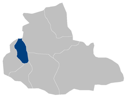 Muqur District within Badghis Province | |
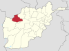
| Country | Afghanistan |
| Province | Badghis |
| Government | |
| • Type | District council |
| Area | |
| • Total | 1,133 km2 (437 sq mi) |
Muqur District is a district located within Badghis Province in the western part of Afghanistan. It is located between the districts of Ab Kamari to the east, Qala i Naw to the south, Qadis to the southeast and Bala Murghab to the northeast. To the north is the national border with Turkmenistan. The district is in a long river valley. The estimated population in 2019 was 26,375.[1][2][3]
References
- ^ "Estimated Population of Afghanistan 2019-20" (PDF). Central Statistics Organization. 18 November 2019. p. 42. Retrieved 12 April 2020.
- ^ "Muqur District (Badghis Province) Rapid WASH Needs Assessment | HumanitarianResponse". www.humanitarianresponse.info. Retrieved 2020-10-05.
- ^ "Muqur District, Badghis, Afghanistan". www.mindat.org. Retrieved 2020-10-05.
- v
- t
- e
Badghis Province
Capital: Qala i Naw
- Ab Kamari
- Ghormach District
- Jawand District
- Muqur District, Badghis
- Bala Murghab District
- Qadis District
- Qala i Naw District
- Ab Bakhsh
- Ab Khuda'i
- Ab Khvor
- Ab-e Barik-e Qowdi
- Abshar
- ʽAli Gol
- Babula'i
- Bahador Khani
- Bahadorkhan
- Bala Bowkan
- Bala Murghab
- Bayah
- Baybacheh
- Bazartu
- Bidak
- Bozba'i
- Chakav
- Chaman-e Bid
- Cheshmeh-ye Duzakh
- Cheshmeh-ye Yanbolaq
- Dahan-e Koklan
- Darreh-ye Bum
- Darreh-ye Joval
- Deh Berenj Qalʽeh
- Dehestan
- Galleh Chaghar
- Gelak
- Gharmeh
- Jawand
- Jowkar
- Kariz-e Zaman-e Bala
- Kariz-e Zaman-e Kalgandi
- Kariz-e Zaman-e Pa'in
- Khar Bid
- Kheyr Khaneh
- Khvajeh Qalandar
- Khvosh Asia
- Khvosh Margh
- Koshk-e Kohneh
- Kowkcha'il
- Kucheh-ye Zard
- Mangan
- Miranza'i
- Murichaq
- Pa'in Bowkan
- Padeh-ye Laghari
- Padeh-ye Nowkdari
- Qades
- Qalʽeh-ye Niaz
- Qalʽeh-ye Nowak
- Qalʽeh-ye Vali
- Qala e Naw (Capital)
- Qeshlaq Khas
- Robat
- Sakhari
- Sangbor
- Seh Kushk
- Senjetak
- Shahr-e Arman
- Shorshoreh
- Tagab Robat
- Takht-e Ghowrmach
35°01′41″N 63°16′12″E / 35.02806°N 63.27000°E / 35.02806; 63.27000
 | This Badghis Province, Afghanistan location article is a stub. You can help Wikipedia by expanding it. |
- v
- t
- e


