National Register of Historic Places listings in Arlington County, Virginia

This is a list of the National Register of Historic Places listings in Arlington County, Virginia.
This is intended to be a complete list of the properties and districts on the National Register of Historic Places in Arlington County, Virginia, United States. The locations of National Register properties and districts for which the latitude and longitude coordinates are included below, may be seen in an online map.[1]
There are 70 properties and districts listed on the National Register in the county, including 5 National Historic Landmarks.
This National Park Service list is complete through NPS recent listings posted April 12, 2024.[2]
Map all coordinates using OpenStreetMap
Download coordinates as:
- KML
- GPX (all coordinates)
- GPX (primary coordinates)
- GPX (secondary coordinates)
Current listings
| [3] | Name on the Register[4] | Image | Date listed[5] | Location | City or town | Description |
|---|---|---|---|---|---|---|
| 1 | Al's Motors | 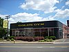 | July 5, 2003 (#03000628) | 3910 Wilson Boulevard 38°52′47″N 77°06′24″W / 38.879722°N 77.106667°W / 38.879722; -77.106667 (Al's Motors) | Ballston | Currently a Gold's Gym |
| 2 | Arlington Forest Historic District |  | December 2, 2005 (#05001344) | Bounded by Carlin Springs Rd., George Mason Dr., Henderson Rd., Aberdeen St., Columbus St., Granada, Galveston, and 2nd 38°52′14″N 77°07′08″W / 38.870556°N 77.118889°W / 38.870556; -77.118889 (Arlington Forest Historic District) | Arlington | |
| 3 | Arlington Heights Historic District |  | February 21, 2008 (#08000063) | Bounded by Arlington Boulevard, S. Fillmore St., S. Walter Reed Dr., Columbia Pk., and S. Glebe Rd. 38°52′03″N 77°05′27″W / 38.867500°N 77.090833°W / 38.867500; -77.090833 (Arlington Heights Historic District) | Arlington | |
| 4 | Arlington House, The Robert E. Lee Memorial |  | October 15, 1966 (#66000040) | Arlington National Cemetery 38°52′52″N 77°04′21″W / 38.881111°N 77.072500°W / 38.881111; -77.072500 (Arlington House, The Robert E. Lee Memorial) | Arlington | Boundary increase on 2014-03-17, listed as the Arlington House Historic District |
| 5 | Arlington Memorial Bridge |  | April 4, 1980 (#80000346) | Spans the Potomac River 38°53′06″N 77°03′44″W / 38.885000°N 77.062222°W / 38.885000; -77.062222 (Arlington Memorial Bridge) | Arlington | Extends into central Washington, D.C. |
| 6 | Arlington National Cemetery Historic District |  | April 11, 2014 (#14000146) | 1 Memorial Drive 38°52′48″N 77°04′12″W / 38.880000°N 77.070000°W / 38.880000; -77.070000 (Arlington National Cemetery Historic District) | Arlington | Includes the cemetery, Arlington House, Memorial Drive, and the Hemicycle |
| 7 | Arlington Ridge Park |  | September 4, 2009 (#09000688) | Northwestern corner of N. Meade St. and Marshall Dr. 38°53′26″N 77°04′11″W / 38.890556°N 77.069722°W / 38.890556; -77.069722 (Arlington Ridge Park) | Arlington | |
| 8 | Arlington Village Historic District | 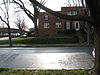 | April 11, 2003 (#03000215) | S. 13th St., S. 13 Rd., S. 16th St., S. Barton S., S. Cleveland St., and Edgewood St. 38°51′33″N 77°05′02″W / 38.859167°N 77.083889°W / 38.859167; -77.083889 (Arlington Village Historic District) | Arlington | |
| 9 | Ashton Heights Historic District | 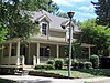 | June 23, 2003 (#03000561) | Roughly bounded by Wilson Boulevard, N. Irving St., Arlington Boulevard, N. Oxford St., N. Piedmont St., and N. Oakland St. 38°51′08″N 77°03′28″W / 38.852222°N 77.057778°W / 38.852222; -77.057778 (Ashton Heights Historic District) | Arlington | |
| 10 | Aurora Highlands Historic District |  | October 22, 2008 (#08001018) | Bounded by 16th St., S., S. Eads St., 26th St., S., and S. Joyce St. 38°51′16″N 77°03′28″W / 38.85445°N 77.057733°W / 38.85445; -77.057733 (Aurora Highlands Historic District) | Arlington | Historic early and mid-20th century suburban development later at the center of a U.S. Supreme Court case that held residential zoned parking constitutional |
| 11 | Ball-Sellers House | 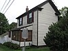 | July 17, 1975 (#75002014) | 5620 S. 3rd St. 38°51′50″N 77°07′30″W / 38.863750°N 77.125000°W / 38.863750; -77.125000 (Ball-Sellers House) | Glencarlyn | |
| 12 | Barcroft Community House |  | July 28, 1995 (#95000928) | 800 S. Buchanan St. 38°51′35″N 77°06′37″W / 38.859639°N 77.110278°W / 38.859639; -77.110278 (Barcroft Community House) | Arlington | |
| 13 | Benjamin Banneker: SW-9 Intermediate Boundary Stone |  | May 11, 1976 (#76002094) | 18th and Van Buren Sts. 38°52′59″N 77°09′33″W / 38.882944°N 77.159083°W / 38.882944; -77.159083 (Benjamin Banneker: SW-9 Intermediate Boundary Stone) | Arlington | |
| 14 | Buckingham Historic District |  | January 21, 1999 (#98001649) | Roughly bounded by N. 5th, N. Oxford, and N. 2nd Sts., and N. Glebe Rd.; also bounded by N. Oxford St., 5th St., N., N. Henderson Rd., 1st St., N., N. Pershing, N. Thomas St., and 2nd St., N.; also bounded by and including N. Thomas St., 4th St., N., N. Pershing Dr., and N. George Mason Dr. 38°52′30″N 77°06′20″W / 38.875000°N 77.105556°W / 38.875000; -77.105556 (Buckingham Historic District) | Arlington | Second and third sets of boundaries represent boundary increases of February 11, 2004 and March 23, 2010 |
| 15 | Calvert Manor | 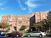 | December 15, 1997 (#97001506) | 1925-1927 N. Calvert St. 38°53′44″N 77°05′31″W / 38.895556°N 77.091944°W / 38.895556; -77.091944 (Calvert Manor) | Arlington | |
| 16 | Carlin Hall | 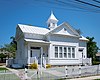 | August 12, 1993 (#93000833) | 5711 4th St., S. 38°51′47″N 77°07′34″W / 38.863194°N 77.126111°W / 38.863194; -77.126111 (Carlin Hall) | Glencarlyn | |
| 17 | Cherrydale Historic District |  | May 22, 2003 (#03000461) | Roughly bounded by Lorcom Ln., N. Utah and N. Taylor Sts., and Interstate 66 38°53′41″N 77°06′12″W / 38.894722°N 77.103333°W / 38.894722; -77.103333 (Cherrydale Historic District) | Cherrydale | |
| 18 | Cherrydale Volunteer Fire House |  | July 28, 1995 (#95000927) | 3900 N. U.S. Route 29 38°53′47″N 77°06′26″W / 38.896389°N 77.107222°W / 38.896389; -77.107222 (Cherrydale Volunteer Fire House) | Cherrydale | |
| 19 | Claremont Historic District |  | August 31, 2006 (#06000751) | Bounded by S. Dinwiddie St., S. Chesterfield Rd., S. Buchanan St., 25th St., S., 24th St., S., 23rd St., S., and 22nd St., S. 38°50′47″N 77°06′20″W / 38.846389°N 77.105556°W / 38.846389; -77.105556 (Claremont Historic District) | Arlington | |
| 20 | Clarendon School |  | December 9, 1999 (#99001502) | 3550 Wilson Boulevard 38°52′54″N 77°06′07″W / 38.881667°N 77.101944°W / 38.881667; -77.101944 (Clarendon School) | Clarendon | Currently the Arlington Arts Center |
| 21 | Colonial Village |  | December 9, 1980 (#80004170) | Roughly bounded by Wilson Boulevard, U.S. Route 29, N. Veitch St., and Queens Lane 38°53′40″N 77°05′00″W / 38.8944°N 77.0833°W / 38.8944; -77.0833 (Colonial Village) | Arlington | |
| 22 | Columbia Forest Historic District | 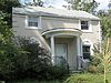 | February 11, 2004 (#04000047) | Bounded by 11th, S. Edison, S. Dinwiddie, S. Columbus, S. George Mason, and S. Frederick St. 38°51′09″N 77°06′41″W / 38.8525°N 77.1114°W / 38.8525; -77.1114 (Columbia Forest Historic District) | Arlington | |
| 23 | George Crossman House |  | May 22, 2003 (#03000455) | 2501 N. Underwood St. 38°53′32″N 77°09′39″W / 38.8922°N 77.1607°W / 38.8922; -77.1607 (George Crossman House) | Arlington | |
| 24 | Dominion Hills Historic District |  | April 24, 2012 (#12000239) | Roughly bounded by N. Four Mile Run Dr., N. McKinley Rd., N. Larrimore, N. Madison, and N. Montana Sts., and 9th St., N. 38°52′33″N 77°08′29″W / 38.8758°N 77.1414°W / 38.8758; -77.1414 (Dominion Hills Historic District) | Arlington | |
| 25 | Charles Richard Drew House |  | May 11, 1976 (#76002095) | 2505 1st St., S. 38°52′22″N 77°05′12″W / 38.8728°N 77.0868°W / 38.8728; -77.0868 (Charles Richard Drew House) | Arlington | |
| 26 | Fairlington Historic District |  | March 29, 1999 (#99000368) | Roughly bounded by Quaker Lane, King St., Interstate 395, S. Walter Reed Dr., and S. Abingdon St. 38°50′17″N 77°05′57″W / 38.8381°N 77.0992°W / 38.8381; -77.0992 (Fairlington Historic District) | Fairlington | |
| 27 | Fort C. F. Smith Historic District | 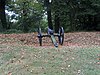 | February 1, 2000 (#99001719) | 2411 24th St. 38°54′06″N 77°05′25″W / 38.9017°N 77.0903°W / 38.9017; -77.0903 (Fort C. F. Smith Historic District) | Arlington | |
| 28 | Fort Ethan Allen | 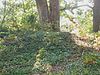 | February 11, 2004 (#04000052) | Junction of Glebe and Ridgeview Rds.[6] 38°55′27″N 77°07′26″W / 38.9242°N 77.1239°W / 38.9242; -77.1239 (Fort Ethan Allen) | Arlington | |
| 29 | Fort Myer Historic District |  | November 28, 1972 (#72001380) | U.S. Route 50 38°52′58″N 77°04′58″W / 38.8828°N 77.0828°W / 38.8828; -77.0828 (Fort Myer Historic District) | Arlington | |
| 30 | George Washington Memorial Parkway |  | June 2, 1995 (#95000605) | Roughly the southern side of the Potomac River from the American Legion Bridge to Memorial Bridge, and the northern side from Brickyard Rd. to the Chain Bridge 38°55′15″N 77°06′33″W / 38.9208°N 77.1092°W / 38.9208; -77.1092 (George Washington Memorial Parkway) | Arlington | |
| 31 | Georgetown Pike |  | August 22, 2012 (#12000537) | From the District of Columbia boundary at Chain Bridge to the junction with Leesburg Pike at Seneca Rd. 38°55′52″N 77°07′09″W / 38.9311°N 77.1192°W / 38.9311; -77.1192 (Georgetown Pike) | Arlington | Extends into Fairfax County |
| 32 | Glebe Apartments | Upload image | November 25, 2020 (#100005835) | 210-212 North Glebe Rd. 38°52′23″N 77°06′14″W / 38.873°N 77.1039°W / 38.873; -77.1039 (Glebe Apartments) | Arlington | |
| 33 | Glebe Center |  | February 11, 2004 (#04000055) | 71-89 N. Glebe Rd. 38°52′20″N 77°06′34″W / 38.8722°N 77.1094°W / 38.8722; -77.1094 (Glebe Center) | Ballston | |
| 34 | The Glebe |  | February 23, 1972 (#72001381) | 4527 17th St., N. 38°53′31″N 77°07′04″W / 38.8919°N 77.1178°W / 38.8919; -77.1178 (The Glebe) | Arlington | Has octagon wing |
| 35 | Glebewood Village Historic District |  | February 11, 2004 (#04000049) | N. Brandywine St. between Lee Highway and 10th Place N., and 21st Rd. between N. Brandywine St. and N. Glebe Rd. 38°53′44″N 77°07′26″W / 38.8956°N 77.1239°W / 38.8956; -77.1239 (Glebewood Village Historic District) | Arlington | |
| 36 | Glencarlyn Historic District |  | September 18, 2008 (#08000910) | Bounded by S. Carlin Springs Rd., Arlington Boulevard, 5th Rd. S., and Glencarlyn Park 38°51′49″N 77°07′35″W / 38.8636°N 77.1264°W / 38.8636; -77.1264 (Glencarlyn Historic District) | Glencarlyn | |
| 37 | Harry W. Gray House | 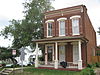 | February 11, 2004 (#64000051) | 1005 S. Quinn St. 38°51′54″N 77°04′29″W / 38.8651°N 77.0747°W / 38.8651; -77.0747 (Harry W. Gray House) | Arlington | |
| 38 | Highland Park-Overlee Knolls |  | August 18, 2011 (#11000548) | Roughly bounded by 22nd St., N., N. Lexington St., 16th St., N., N. Longfellow St., McKinley Rd., Interstate 66, and N. Quantico St. 38°53′12″N 77°08′49″W / 38.8867°N 77.1469°W / 38.8867; -77.1469 (Highland Park-Overlee Knolls) | Arlington | |
| 39 | Hume School |  | June 18, 1979 (#79003027) | 1805 S. Arlington Ridge Rd. 38°51′32″N 77°04′03″W / 38.8588°N 77.0675°W / 38.8588; -77.0675 (Hume School) | Arlington | |
| 40 | Francis Scott Key Bridge |  | March 1, 1996 (#96000199) | U.S. Route 29 over the Potomac River 38°54′05″N 77°04′13″W / 38.9014°N 77.0703°W / 38.9014; -77.0703 (Francis Scott Key Bridge) | Arlington | |
| 41 | Lee Gardens North Historic District | 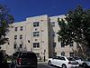 | February 26, 2004 (#04000109) | 2300-2341 N. 11th St. 38°53′08″N 77°05′12″W / 38.8856°N 77.0867°W / 38.8856; -77.0867 (Lee Gardens North Historic District) | Arlington | |
| 42 | Lomax African Methodist Episcopal Zion Church |  | February 11, 2004 (#04000038) | 2704 24th Rd., S. 38°50′52″N 77°04′56″W / 38.847778°N 77.082222°W / 38.847778; -77.082222 (Lomax African Methodist Episcopal Zion Church) | Arlington | |
| 43 | Lyon Park Historic District |  | November 12, 2003 (#03000437) | Roughly bounded by 10th St., N., Arlington Boulevard, and N. Irving St. 38°52′45″N 77°05′26″W / 38.879167°N 77.090556°W / 38.879167; -77.090556 (Lyon Park Historic District) | Arlington | |
| 44 | Lyon Village Historic District |  | May 10, 2002 (#02000512) | Roughly bounded by U.S. Route 29, N. Veitch St., N. Franklin Rd., N. Highland St., N. Fillmore St., and N. Kirkwood Rd. 38°53′29″N 77°05′42″W / 38.891389°N 77.095000°W / 38.891389; -77.095000 (Lyon Village Historic District) | Arlington | |
| 45 | Maywood Historic District |  | May 22, 2003 (#03000460) | Roughly bounded by Lorcom Ln., Spout Run Parkway, Interstate 66, U.S. Route 29, N. Oakland St., N. Nelson St., and N. Lincoln St. 38°53′53″N 77°06′05″W / 38.898056°N 77.101389°W / 38.898056; -77.101389 (Maywood Historic District) | Arlington | |
| 46 | Monroe Courts Historic District |  | February 21, 2008 (#08000064) | 1041-1067 N. Nelson and 1036-1062 and 1033-1055 N. Monroe Sts. 38°53′08″N 77°06′16″W / 38.885556°N 77.104444°W / 38.885556; -77.104444 (Monroe Courts Historic District) | Arlington | |
| 47 | Mount Vernon Memorial Highway | 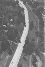 | May 18, 1981 (#81000079) | Washington St. and George Washington Memorial Parkway 38°51′54″N 77°02′29″W / 38.865000°N 77.041389°W / 38.865000; -77.041389 (Mount Vernon Memorial Highway) | Arlington | |
| 48 | Northwest No. 1 Boundary Marker of the Original District of Columbia |  | February 1, 1991 (#91000003) | 3607 Powhatan St. 38°54′12″N 77°09′33″W / 38.903472°N 77.159167°W / 38.903472; -77.159167 (Northwest No. 1 Boundary Marker of the Original District of Columbia) | Arlington | |
| 49 | Northwest No. 2 Boundary Marker of the Original District of Columbia |  | February 1, 1991 (#91000004) | 5145 N. 38th St. 38°54′49″N 77°08′46″W / 38.913667°N 77.146111°W / 38.913667; -77.146111 (Northwest No. 2 Boundary Marker of the Original District of Columbia) | Arlington | |
| 50 | Northwest No. 3 Boundary Marker of the Original District of Columbia |  | February 1, 1991 (#91000005) | 4013 N. Tazewell St. 38°55′28″N 77°07′55″W / 38.924583°N 77.132083°W / 38.924583; -77.132083 (Northwest No. 3 Boundary Marker of the Original District of Columbia) | Arlington | |
| 51 | Penrose Historic District |  | November 15, 2004 (#04000112) | Roughly bounded by Arlington Boulevard, S. Courthouse Rd., S. Fillmore St., S. Barton St., and Columbia Pike 38°52′08″N 77°05′04″W / 38.868889°N 77.084444°W / 38.868889; -77.084444 (Penrose Historic District) | Arlington | |
| 52 | Pentagon Office Building Complex | 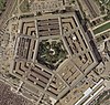 | July 27, 1989 (#89000932) | State Route 110 at Interstate 395 38°52′16″N 77°03′23″W / 38.871111°N 77.056389°W / 38.871111; -77.056389 (Pentagon Office Building Complex) | Pentagon City | Boundary increase approved September 11, 2023. |
| 53 | Quarters 1, Fort Myer | 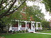 | November 28, 1972 (#72001382) | Grant Ave. 38°52′58″N 77°04′53″W / 38.882778°N 77.081389°W / 38.882778; -77.081389 (Quarters 1, Fort Myer) | Arlington | |
| 54 | Saegmuller House |  | May 22, 2003 (#03000453) | 5101 Little Falls Rd. 38°54′22″N 77°08′24″W / 38.906111°N 77.140000°W / 38.906111; -77.140000 (Saegmuller House) | Arlington | |
| 55 | Southwest No. 4 Boundary Marker of the Original District of Columbia |  | February 1, 1991 (#91000009) | King St. north of the junction with Wakefield St. 38°49′54″N 77°05′36″W / 38.831667°N 77.093333°W / 38.831667; -77.093333 (Southwest No. 4 Boundary Marker of the Original District of Columbia) | Alexandria | |
| 56 | Southwest No. 5 Boundary Marker of the Original District of Columbia |  | February 1, 1991 (#91000010) | Northeast of the junction of King St. and Walter Reed Dr. 38°50′31″N 77°06′24″W / 38.842083°N 77.106667°W / 38.842083; -77.106667 (Southwest No. 5 Boundary Marker of the Original District of Columbia) | Arlington | |
| 57 | Southwest No. 6 Boundary Marker of the Original District of Columbia |  | February 1, 1991 (#91000011) | S. Jefferson St. south of the junction with Columbia Pike, in the median strip 38°51′07″N 77°07′09″W / 38.851861°N 77.119250°W / 38.851861; -77.119250 (Southwest No. 6 Boundary Marker of the Original District of Columbia) | Arlington | |
| 58 | Southwest No. 7 Boundary Marker of the Original District of Columbia |  | February 1, 1991 (#91000012) | Behind 3101 S. Manchester St. 38°51′44″N 77°07′57″W / 38.862361°N 77.132500°W / 38.862361; -77.132500 (Southwest No. 7 Boundary Marker of the Original District of Columbia) | Arlington | |
| 59 | Southwest No. 8 Boundary Marker of the Original District of Columbia |  | February 1, 1991 (#91000013) | Junction of Wilson Boulevard and John Marshall Dr., behind an apartment building 38°52′22″N 77°08′45″W / 38.872639°N 77.145861°W / 38.872639; -77.145861 (Southwest No. 8 Boundary Marker of the Original District of Columbia) | Arlington | Extends into Fairfax County |
| 60 | Stratford Junior High School | 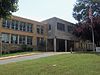 | February 26, 2004 (#04000110) | 4100 Vacation Ln. 38°54′00″N 77°06′44″W / 38.900000°N 77.112222°W / 38.900000; -77.112222 (Stratford Junior High School) | Cherrydale | |
| 61 | Unitarian Universalist Church of Arlington |  | November 19, 2014 (#14000943) | 4444 Arlington Boulevard 38°52′06″N 77°06′27″W / 38.868333°N 77.107500°W / 38.868333; -77.107500 (Unitarian Universalist Church of Arlington) | Arlington | |
| 62 | US Post Office-Arlington | 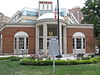 | February 7, 1986 (#86000151) | 3118 N. Washington Boulevard 38°53′08″N 77°05′44″W / 38.885556°N 77.095417°W / 38.885556; -77.095417 (US Post Office-Arlington) | Clarendon | |
| 63 | Virginia Heights Historic District |  | February 21, 2008 (#08000065) | Bounded by 10th Pl., S., S. Frederick St., and S. George Mason Dr. 38°51′02″N 77°06′53″W / 38.850556°N 77.114722°W / 38.850556; -77.114722 (Virginia Heights Historic District) | Arlington | |
| 64 | Walter Reed Gardens Historic District |  | May 22, 2003 (#03000451) | 2900-2906 13th St., S., 2900-2914 13th Rd., S., and 1301-1319 S. Walter Reed Dr. 38°51′33″N 77°05′13″W / 38.859167°N 77.086944°W / 38.859167; -77.086944 (Walter Reed Gardens Historic District) | Arlington | |
| 65 | Washington National Airport Terminal and South Hangar Line | 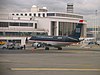 | September 12, 1997 (#97001111) | Thomas Ave. 38°50′56″N 77°02′30″W / 38.848889°N 77.041667°W / 38.848889; -77.041667 (Washington National Airport Terminal and South Hangar Line) | Arlington | |
| 66 | Waverly Hills Historic District |  | February 26, 2004 (#04000111) | Roughly bounded by 20th Rd., N., N. Utah St, Interstate 66, N. Glebe Rd., and N. Vermont St. 38°53′31″N 77°07′02″W / 38.891944°N 77.117222°W / 38.891944; -77.117222 (Waverly Hills Historic District) | Arlington | |
| 67 | West Cornerstone | 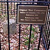 | February 1, 1991 (#91000014) | Western side of Meridian St., south of the junction with Williamsburg Boulevard 38°53′36″N 77°10′20″W / 38.893333°N 77.172222°W / 38.893333; -77.172222 (West Cornerstone) | Falls Church | |
| 68 | Westover Historic District |  | May 2, 2006 (#06000345) | Bounded by McKinley Rd., N. Washington Boulevard, N. 16th St., N. Jefferson St., N. 11th St., and N. Fairfax Dr. 38°52′58″N 77°08′11″W / 38.882775°N 77.136525°W / 38.882775; -77.136525 (Westover Historic District) | Arlington | |
| 69 | Windsor Apartments | Upload image | May 13, 2021 (#100006520) | 20-204 North Thomas St. 38°52′16″N 77°06′18″W / 38.8711°N 77.1049°W / 38.8711; -77.1049 (Windsor Apartments) | Arlington | |
| 70 | Earle Micajah Winslow House |  | February 22, 2011 (#11000028) | 2333 N. Vernon St. 38°54′06″N 77°07′09″W / 38.901667°N 77.119167°W / 38.901667; -77.119167 (Earle Micajah Winslow House) | Arlington |
See also
Wikimedia Commons has media related to National Register of Historic Places in Arlington County, Virginia.
- List of National Historic Landmarks in Virginia
- National Register of Historic Places listings in Virginia
- National Register of Historic Places listings in Falls Church, Virginia
- National Register of Historic Places listings in Alexandria, Virginia
References
- ^ The latitude and longitude information provided in this table was derived originally from the National Register Information System, which has been found to be fairly accurate for about 99% of listings. Some locations in this table may have been corrected to current GPS standards.
- ^ National Park Service, United States Department of the Interior, "National Register of Historic Places: Weekly List Actions", retrieved April 12, 2024.
- ^ Numbers represent an alphabetical ordering by significant words. Various colorings, defined here, differentiate National Historic Landmarks and historic districts from other NRHP buildings, structures, sites or objects.
- ^ "National Register Information System". National Register of Historic Places. National Park Service. April 24, 2008.
- ^ The eight-digit number below each date is the number assigned to each location in the National Register Information System database, which can be viewed by clicking the number.
- ^ Trieschmann, Laura V. National Register of Historic Places Inventory/Nomination: Fort Ethan Allen. National Park Service, 2003-08, 33.
- v
- t
- e
by county
- Accomack
- Albemarle
- Alleghany
- Amelia
- Amherst
- Appomattox
- Arlington
- Augusta
- Bath
- Bedford
- Bland
- Botetourt
- Brunswick
- Buchanan
- Buckingham
- Campbell
- Caroline
- Carroll
- Charles City
- Charlotte
- Chesterfield
- Clarke
- Craig
- Culpeper
- Cumberland
- Dickenson
- Dinwiddie
- Essex
- Fairfax
- Fauquier
- Floyd
- Fluvanna
- Franklin
- Frederick
- Giles
- Gloucester
- Goochland
- Grayson
- Greene
- Greensville
- Halifax
- Hanover
- Henrico
- Henry
- Highland
- Isle Of Wight
- James City
- King and Queen
- King George
- King William
- Lancaster
- Lee
- Loudoun
- Louisa
- Lunenburg
- Madison
- Mathews
- Mecklenburg
- Middlesex
- Montgomery
- Nelson
- New Kent
- Northampton
- Northumberland
- Nottoway
- Orange
- Page
- Patrick
- Pittsylvania
- Powhatan
- Prince Edward
- Prince George
- Prince William
- Pulaski
- Rappahannock
- Richmond
- Roanoke
- Rockbridge
- Rockingham
- Russell
- Scott
- Shenandoah
- Smyth
- Southampton
- Spotsylvania
- Stafford
- Surry
- Sussex
- Tazewell
- Warren
- Washington
- Westmoreland
- Wise
- Wythe
- York

by city
- Alexandria
- Bristol
- Buena Vista
- Charlottesville
- Chesapeake
- Colonial Heights
- Covington
- Danville
- Emporia
- Fairfax
- Falls Church
- Franklin
- Fredericksburg
- Galax
- Hampton
- Harrisonburg
- Hopewell
- Lexington
- Lynchburg
- Manassas
- Manassas Park
- Martinsville
- Newport News
- Norfolk
- Norton
- Petersburg
- Poquoson (no listings)
- Portsmouth
- Radford
- Richmond
- Roanoke
- Salem
- Staunton
- Suffolk
- Virginia Beach
- Waynesboro
- Williamsburg
- Winchester
Municipalities and communities of Arlington County, Virginia, United States | ||
|---|---|---|
County seat: Court House | ||
| Unincorporated communities |
|  |
| ||


