National Register of Historic Places listings in Emporia, Virginia

This is a list of the National Register of Historic Places listings in Emporia, Virginia.
This is intended to be a complete list of the properties and districts on the National Register of Historic Places in the independent city of Emporia, Virginia, United States. The locations of National Register properties and districts for which the latitude and longitude coordinates are included below, may be seen in a Google map.[1]
There are 7 properties and districts listed on the National Register in the city.
This National Park Service list is complete through NPS recent listings posted April 12, 2024.[2]
Map all coordinates using OpenStreetMap
Download coordinates as:
- KML
- GPX (all coordinates)
- GPX (primary coordinates)
- GPX (secondary coordinates)
Current listings
| [3] | Name on the Register[4] | Image | Date listed[5] | Location | Description |
|---|---|---|---|---|---|
| 1 | Belfield-Emporia Historic District |  | November 1, 2007 (#07001137) | Roughly bounded by the railroad line, Atlantic Ave., and Budd and Valley Sts. 36°41′36″N 77°32′16″W / 36.693333°N 77.537778°W / 36.693333; -77.537778 (Belfield-Emporia Historic District) | |
| 2 | Greensville County Courthouse Complex |  | July 21, 1983 (#83003279) | S. Main St. 36°41′11″N 77°32′32″W / 36.686389°N 77.542222°W / 36.686389; -77.542222 (Greensville County Courthouse Complex) | |
| 3 | Greensville County Training School |  | March 8, 2006 (#06000122) | 105 Ruffin St. 36°41′56″N 77°32′07″W / 36.698889°N 77.535278°W / 36.698889; -77.535278 (Greensville County Training School) | |
| 4 | Hicksford-Emporia Historic District |  | November 20, 2007 (#07001217) | S. Main St. and Brunswick Ave. 36°41′12″N 77°32′34″W / 36.686667°N 77.542778°W / 36.686667; -77.542778 (Hicksford-Emporia Historic District) | |
| 5 | H. T. Klugel Architectural Sheet Metal Work Building | 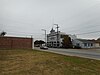 | April 2, 1973 (#73002208) | 135 Atlantic Ave. 36°41′40″N 77°32′11″W / 36.694444°N 77.536389°W / 36.694444; -77.536389 (H. T. Klugel Architectural Sheet Metal Work Building) | |
| 6 | Old Merchants and Farmers Bank Building | 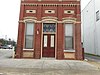 | May 7, 1979 (#79003278) | 419 S. Main St. 36°41′08″N 77°32′35″W / 36.685417°N 77.542917°W / 36.685417; -77.542917 (Old Merchants and Farmers Bank Building) | |
| 7 | Village View |  | September 16, 1982 (#82004554) | 221 Briggs St. 36°40′51″N 77°32′34″W / 36.680833°N 77.542778°W / 36.680833; -77.542778 (Village View) |
See also
Wikimedia Commons has media related to National Register of Historic Places in Emporia, Virginia.
- List of National Historic Landmarks in Virginia
- National Register of Historic Places listings in Virginia
- National Register of Historic Places listings in Greensville County, Virginia
References
- ^ The latitude and longitude information provided in this table was derived originally from the National Register Information System, which has been found to be fairly accurate for about 99% of listings. Some locations in this table may have been corrected to current GPS standards.
- ^ National Park Service, United States Department of the Interior, "National Register of Historic Places: Weekly List Actions", retrieved April 12, 2024.
- ^ Numbers represent an alphabetical ordering by significant words. Various colorings, defined here, differentiate National Historic Landmarks and historic districts from other NRHP buildings, structures, sites or objects.
- ^ "National Register Information System". National Register of Historic Places. National Park Service. April 24, 2008.
- ^ The eight-digit number below each date is the number assigned to each location in the National Register Information System database, which can be viewed by clicking the number.
- v
- t
- e
by county
- Accomack
- Albemarle
- Alleghany
- Amelia
- Amherst
- Appomattox
- Arlington
- Augusta
- Bath
- Bedford
- Bland
- Botetourt
- Brunswick
- Buchanan
- Buckingham
- Campbell
- Caroline
- Carroll
- Charles City
- Charlotte
- Chesterfield
- Clarke
- Craig
- Culpeper
- Cumberland
- Dickenson
- Dinwiddie
- Essex
- Fairfax
- Fauquier
- Floyd
- Fluvanna
- Franklin
- Frederick
- Giles
- Gloucester
- Goochland
- Grayson
- Greene
- Greensville
- Halifax
- Hanover
- Henrico
- Henry
- Highland
- Isle Of Wight
- James City
- King and Queen
- King George
- King William
- Lancaster
- Lee
- Loudoun
- Louisa
- Lunenburg
- Madison
- Mathews
- Mecklenburg
- Middlesex
- Montgomery
- Nelson
- New Kent
- Northampton
- Northumberland
- Nottoway
- Orange
- Page
- Patrick
- Pittsylvania
- Powhatan
- Prince Edward
- Prince George
- Prince William
- Pulaski
- Rappahannock
- Richmond
- Roanoke
- Rockbridge
- Rockingham
- Russell
- Scott
- Shenandoah
- Smyth
- Southampton
- Spotsylvania
- Stafford
- Surry
- Sussex
- Tazewell
- Warren
- Washington
- Westmoreland
- Wise
- Wythe
- York

by city
- Alexandria
- Bristol
- Buena Vista
- Charlottesville
- Chesapeake
- Colonial Heights
- Covington
- Danville
- Emporia
- Fairfax
- Falls Church
- Franklin
- Fredericksburg
- Galax
- Hampton
- Harrisonburg
- Hopewell
- Lexington
- Lynchburg
- Manassas
- Manassas Park
- Martinsville
- Newport News
- Norfolk
- Norton
- Petersburg
- Poquoson (no listings)
- Portsmouth
- Radford
- Richmond
- Roanoke
- Salem
- Staunton
- Suffolk
- Virginia Beach
- Waynesboro
- Williamsburg
- Winchester


