National Register of Historic Places listings in Staunton, Virginia

This is a list of the National Register of Historic Places listings in Staunton, Virginia.
This is intended to be a complete list of the properties and districts on the National Register of Historic Places in the independent city of Staunton, Virginia, United States. The locations of National Register properties and districts for which the latitude and longitude coordinates are included below, may be seen in an online map.[1]
There are 35 properties and districts listed on the National Register in the city, including 1 National Historic Landmark.
This National Park Service list is complete through NPS recent listings posted April 12, 2024.[2]
Map all coordinates using OpenStreetMap
Download coordinates as:
- KML
- GPX (all coordinates)
- GPX (primary coordinates)
- GPX (secondary coordinates)
Current listings
| [3] | Name on the Register[4] | Image | Date listed[5] | Location | Description |
|---|---|---|---|---|---|
| 1 | Augusta County Courthouse | 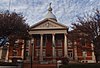 | October 26, 1982 (#82001826) | 1 E. Johnson St. 38°08′56″N 79°04′20″W / 38.148889°N 79.072222°W / 38.148889; -79.072222 (Augusta County Courthouse) | |
| 2 | Mary Baldwin College, Main Building |  | July 26, 1973 (#73002227) | Mary Baldwin University campus 38°09′04″N 79°04′17″W / 38.151111°N 79.071389°W / 38.151111; -79.071389 (Mary Baldwin College, Main Building) | |
| 3 | Beverley Historic District |  | July 14, 1982 (#82004598) | U.S. Route 250 and State Route 254 38°08′57″N 79°04′22″W / 38.149167°N 79.072778°W / 38.149167; -79.072778 (Beverley Historic District) | |
| 4 | Breezy Hill |  | July 8, 1982 (#82004599) | 1220 N. Augusta St. 38°09′37″N 79°04′10″W / 38.160278°N 79.069444°W / 38.160278; -79.069444 (Breezy Hill) | |
| 5 | Catlett House |  | July 15, 1982 (#82004600) | 303 Berkeley Pl. 38°09′03″N 79°04′06″W / 38.150833°N 79.068333°W / 38.150833; -79.068333 (Catlett House) | |
| 6 | Cobble Hill Farm |  | February 25, 2004 (#04000105) | 101 Woodlee Rd. 38°10′20″N 79°03′53″W / 38.172222°N 79.064722°W / 38.172222; -79.064722 (Cobble Hill Farm) | |
| 7 | Goodloe House | Upload image | November 10, 2022 (#100008392) | 25 Ridgeview Rd. 38°09′40″N 79°04′00″W / 38.1611°N 79.0668°W / 38.1611; -79.0668 (Goodloe House) | |
| 8 | Gospel Hill Historic District |  | February 14, 1985 (#85000299) | Roughly bounded by E. Beverly, N. Market, E. Frederick, and Kalorama Sts. 38°09′06″N 79°04′01″W / 38.151667°N 79.066944°W / 38.151667; -79.066944 (Gospel Hill Historic District) | |
| 9 | Hilltop | 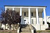 | June 19, 1979 (#79003298) | Mary Baldwin University campus 38°09′07″N 79°04′17″W / 38.151944°N 79.071389°W / 38.151944; -79.071389 (Hilltop) | |
| 10 | Arista Hoge House |  | July 15, 1982 (#82004601) | 215 Kalorama St. 38°08′55″N 79°04′11″W / 38.148611°N 79.069722°W / 38.148611; -79.069722 (Arista Hoge House) | |
| 11 | Kable House |  | June 19, 1979 (#79003299) | 310 Prospect St. 38°09′15″N 79°04′09″W / 38.154167°N 79.069167°W / 38.154167; -79.069167 (Kable House) | |
| 12 | Robert E. Lee High School |  | March 10, 2009 (#09000122) | 274 Churchville Ave. 38°09′25″N 79°04′40″W / 38.156944°N 79.077778°W / 38.156944; -79.077778 (Robert E. Lee High School) | |
| 13 | J.C.M. Merrillat House |  | September 16, 1982 (#82004602) | 521 E. Beverley St. 38°09′09″N 79°03′55″W / 38.152500°N 79.065278°W / 38.152500; -79.065278 (J.C.M. Merrillat House) | |
| 14 | Thomas J. Michie House | 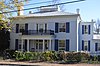 | September 9, 1982 (#82004603) | 324 E. Beverley St. 38°08′59″N 79°04′03″W / 38.149722°N 79.067500°W / 38.149722; -79.067500 (Thomas J. Michie House) | |
| 15 | C.W. Miller House |  | June 19, 1979 (#79003300) | 210 N. New St. 38°09′07″N 79°04′20″W / 38.151944°N 79.072222°W / 38.151944; -79.072222 (C.W. Miller House) | |
| 16 | Montgomery Hall Park |  | February 15, 2018 (#100002139) | 1000 Montgomery Ave. 38°08′44″N 79°05′30″W / 38.145556°N 79.091667°W / 38.145556; -79.091667 (Montgomery Hall Park) | |
| 17 | National Valley Bank |  | June 19, 1979 (#79003301) | 12-14 W. Beverly St. 38°08′58″N 79°04′23″W / 38.149306°N 79.073056°W / 38.149306; -79.073056 (National Valley Bank) | |
| 18 | Newtown Historic District |  | September 8, 1983 (#83003318) | Roughly bounded by Lewis St. and S. Jefferson Sts., the former Chesapeake and Ohio railroad line, and Allegheny and Churchville Aves., including Thornrose Cemetery 38°09′00″N 79°04′40″W / 38.150000°N 79.077778°W / 38.150000; -79.077778 (Newtown Historic District) | |
| 19 | Oakdene | 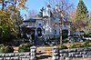 | November 24, 1982 (#82001827) | 605 E. Beverley St. 38°09′08″N 79°03′52″W / 38.152222°N 79.064583°W / 38.152222; -79.064583 (Oakdene) | |
| 20 | The Oaks |  | June 19, 1979 (#79003302) | 437 E. Beverly St. 38°09′06″N 79°03′58″W / 38.151667°N 79.066111°W / 38.151667; -79.066111 (The Oaks) | |
| 21 | Old Main |  | August 13, 1974 (#74002246) | 235 W. Frederick St. 38°09′02″N 79°04′36″W / 38.150556°N 79.076667°W / 38.150556; -79.076667 (Old Main) | |
| 22 | Rose Terrace |  | June 19, 1979 (#79003303) | 150 N. Market St. 38°09′08″N 79°04′16″W / 38.152222°N 79.071111°W / 38.152222; -79.071111 (Rose Terrace) | |
| 23 | Sears House |  | February 23, 1972 (#72001530) | Sears Hill Rd. in Woodrow Wilson City Park 38°08′45″N 79°04′20″W / 38.145833°N 79.072222°W / 38.145833; -79.072222 (Sears House) | |
| 24 | Staunton National Cemetery | 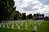 | February 26, 1996 (#96000034) | 901 Richmond Ave. 38°08′25″N 79°02′59″W / 38.140278°N 79.049722°W / 38.140278; -79.049722 (Staunton National Cemetery) | |
| 25 | Staunton Steam Laundry | Upload image | August 18, 2022 (#100008023) | 110 West Hampton, 709 Hall, and 710 Robertson Sts. 38°08′36″N 79°04′32″W / 38.1434°N 79.0756°W / 38.1434; -79.0756 (Staunton Steam Laundry) | |
| 26 | Steephill |  | February 23, 1984 (#84003599) | 200 Park Boulevard 38°09′22″N 79°05′16″W / 38.156111°N 79.087778°W / 38.156111; -79.087778 (Steephill) | |
| 27 | Stuart Addition Historic District |  | May 3, 1984 (#84003604) | Roughly bounded by Augusta, Sunnyside, Market, and New Sts. 38°09′11″N 79°04′19″W / 38.153056°N 79.071944°W / 38.153056; -79.071944 (Stuart Addition Historic District) | |
| 28 | Stuart House |  | May 5, 1972 (#72001531) | 120 Church St. 38°08′51″N 79°04′33″W / 38.147500°N 79.075833°W / 38.147500; -79.075833 (Stuart House) | |
| 29 | Trinity Episcopal Church |  | May 5, 1972 (#72001532) | Beverley and Lewis Sts. 38°08′56″N 79°04′31″W / 38.148889°N 79.075278°W / 38.148889; -79.075278 (Trinity Episcopal Church) | |
| 30 | Virginia School for the Deaf and the Blind |  | November 12, 1969 (#69000361) | E. Beverly St. and Pleasant Terrace 38°09′02″N 79°03′50″W / 38.150556°N 79.063889°W / 38.150556; -79.063889 (Virginia School for the Deaf and the Blind) | |
| 31 | Booker T. Washington High School |  | September 3, 2014 (#14000550) | 1114 W. Johnson St. 38°08′51″N 79°04′54″W / 38.147500°N 79.081667°W / 38.147500; -79.081667 (Booker T. Washington High School) | |
| 32 | Waverly Hill |  | July 8, 1982 (#82004604) | 3001 N. Augusta St. 38°10′10″N 79°02′40″W / 38.169444°N 79.044444°W / 38.169444; -79.044444 (Waverly Hill) | |
| 33 | Western State Hospital Complex |  | November 25, 1969 (#69000362) | Junction of U.S. Routes 11 and 250; also 301 Greenville Ave. and the southeastern corner of the junction of U.S. Routes 11 and 250 38°08′42″N 79°04′02″W / 38.145000°N 79.067222°W / 38.145000; -79.067222 (Western State Hospital Complex) | Boundaries repeatedly increased at 301 Greenville Ave., on February 21, 2007, July 24, 2007, and March 23, 2010 |
| 34 | Wharf Area Historic District |  | November 9, 1972 (#72001533) | Middlebrook Ave. between S. New and S. Lewis Sts., including S. Augusta St. to Johnson St.; also east to Lewis Creek 38°08′51″N 79°04′23″W / 38.147500°N 79.073056°W / 38.147500; -79.073056 (Wharf Area Historic District) | Lewis Creek represents a boundary increase of July 19, 1982 |
| 35 | Woodrow Wilson Birthplace |  | October 15, 1966 (#66000926) | N. Coalter St. between Beverly and Frederick Sts. 38°09′02″N 79°04′08″W / 38.150694°N 79.068889°W / 38.150694; -79.068889 (Woodrow Wilson Birthplace) |
See also
Wikimedia Commons has media related to National Register of Historic Places in Staunton, Virginia.
- List of National Historic Landmarks in Virginia
- National Register of Historic Places listings in Virginia
- National Register of Historic Places listings in Augusta County, Virginia
References
- ^ The latitude and longitude information provided in this table was derived originally from the National Register Information System, which has been found to be fairly accurate for about 99% of listings. Some locations in this table may have been corrected to current GPS standards.
- ^ National Park Service, United States Department of the Interior, "National Register of Historic Places: Weekly List Actions", retrieved April 12, 2024.
- ^ Numbers represent an alphabetical ordering by significant words. Various colorings, defined here, differentiate National Historic Landmarks and historic districts from other NRHP buildings, structures, sites or objects.
- ^ "National Register Information System". National Register of Historic Places. National Park Service. April 24, 2008.
- ^ The eight-digit number below each date is the number assigned to each location in the National Register Information System database, which can be viewed by clicking the number.
- v
- t
- e
by county
- Accomack
- Albemarle
- Alleghany
- Amelia
- Amherst
- Appomattox
- Arlington
- Augusta
- Bath
- Bedford
- Bland
- Botetourt
- Brunswick
- Buchanan
- Buckingham
- Campbell
- Caroline
- Carroll
- Charles City
- Charlotte
- Chesterfield
- Clarke
- Craig
- Culpeper
- Cumberland
- Dickenson
- Dinwiddie
- Essex
- Fairfax
- Fauquier
- Floyd
- Fluvanna
- Franklin
- Frederick
- Giles
- Gloucester
- Goochland
- Grayson
- Greene
- Greensville
- Halifax
- Hanover
- Henrico
- Henry
- Highland
- Isle Of Wight
- James City
- King and Queen
- King George
- King William
- Lancaster
- Lee
- Loudoun
- Louisa
- Lunenburg
- Madison
- Mathews
- Mecklenburg
- Middlesex
- Montgomery
- Nelson
- New Kent
- Northampton
- Northumberland
- Nottoway
- Orange
- Page
- Patrick
- Pittsylvania
- Powhatan
- Prince Edward
- Prince George
- Prince William
- Pulaski
- Rappahannock
- Richmond
- Roanoke
- Rockbridge
- Rockingham
- Russell
- Scott
- Shenandoah
- Smyth
- Southampton
- Spotsylvania
- Stafford
- Surry
- Sussex
- Tazewell
- Warren
- Washington
- Westmoreland
- Wise
- Wythe
- York

by city
- Alexandria
- Bristol
- Buena Vista
- Charlottesville
- Chesapeake
- Colonial Heights
- Covington
- Danville
- Emporia
- Fairfax
- Falls Church
- Franklin
- Fredericksburg
- Galax
- Hampton
- Harrisonburg
- Hopewell
- Lexington
- Lynchburg
- Manassas
- Manassas Park
- Martinsville
- Newport News
- Norfolk
- Norton
- Petersburg
- Poquoson (no listings)
- Portsmouth
- Radford
- Richmond
- Roanoke
- Salem
- Staunton
- Suffolk
- Virginia Beach
- Waynesboro
- Williamsburg
- Winchester


