National Register of Historic Places listings in Carroll County, Kentucky

This is a list of the National Register of Historic Places listings in Carroll County, Kentucky.
This is intended to be a complete list of the properties and districts on the National Register of Historic Places in Carroll County, Kentucky, United States. The locations of National Register properties and districts for which the latitude and longitude coordinates are included below, may be seen in a map.[1]
There are 11 properties and districts listed on the National Register in the county.
This National Park Service list is complete through NPS recent listings posted September 5, 2024.[2]
Map all coordinates using OpenStreetMap
Download coordinates as:
- KML
- GPX (all coordinates)
- GPX (primary coordinates)
- GPX (secondary coordinates)
Current
| [3] | Name on the Register | Image | Date listed[4] | Location | City or town | Description |
|---|---|---|---|---|---|---|
| 1 | Paschal Todd Baker House | 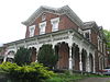 | November 25, 1980 (#80001496) | 406 Highland Ave. 38°40′50″N 85°10′53″W / 38.680694°N 85.181250°W / 38.680694; -85.181250 (Paschal Todd Baker House) | Carrollton | |
| 2 | Gen. William O. Butler House |  | May 28, 1976 (#76000861) | Highland Ave. 38°40′54″N 85°10′31″W / 38.681667°N 85.175278°W / 38.681667; -85.175278 (Gen. William O. Butler House) | Carrollton | |
| 3 | Carrollton Historic District |  | November 12, 1982 (#82001553) | Roughly bounded by Main, Polk, 2nd, 7th, and both sides of Highland Ave. to 11th St. 38°40′45″N 85°10′40″W / 38.679167°N 85.177778°W / 38.679167; -85.177778 (Carrollton Historic District) | Carrollton | |
| 4 | Ghent Historic District |  | August 25, 1983 (#83002623) | U.S. Route 42, Fishing, Ann, Main Cross, Ferry, Water, Union, and Liberty Sts. 38°44′18″N 85°03′36″W / 38.738333°N 85.060000°W / 38.738333; -85.060000 (Ghent Historic District) | Ghent | |
| 5 | Grass Hills | Upload image | August 22, 1975 (#75000743) | 5 miles southeast of Ghent on Kentucky Route 47 at Interstate 71 38°40′21″N 85°00′26″W / 38.6725°N 85.007222°W / 38.6725; -85.007222 (Grass Hills) | Ghent | |
| 6 | Hunter's Bottom Historic District | 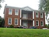 | August 11, 1976 (#76000862) | West of Carrollton 38°43′23″N 85°17′31″W / 38.723056°N 85.291944°W / 38.723056; -85.291944 (Hunter's Bottom Historic District) | Carrollton | Extends into Trimble County |
| 7 | Richard Masterson House |  | July 1, 1975 (#75000742) | East of the junction of U.S. Routes 42 and 227 38°41′20″N 85°09′05″W / 38.688889°N 85.151500°W / 38.688889; -85.151500 (Richard Masterson House) | Carrollton | |
| 8 | Henry Ogburn House |  | January 8, 1987 (#87000149) | Off U.S. Route 42 38°41′29″N 85°07′57″W / 38.691389°N 85.132500°W / 38.691389; -85.132500 (Henry Ogburn House) | Carrollton | |
| 9 | Richlawn Farm | 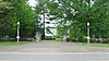 | March 24, 2000 (#00000274) | 1705 Highland Ave. 38°41′11″N 85°09′32″W / 38.686389°N 85.158889°W / 38.686389; -85.158889 (Richlawn Farm) | Carrollton | |
| 10 | Stone House on Kentucky River | Upload image | January 8, 1987 (#87000151) | Kentucky Route 55 38°40′21″N 85°11′39″W / 38.672500°N 85.194167°W / 38.672500; -85.194167 (Stone House on Kentucky River) | Prestonville | |
| 11 | Turpin House | Upload image | December 2, 1977 (#77000606) | Butler State Park off 11th St. 38°40′09″N 85°09′56″W / 38.669167°N 85.165556°W / 38.669167; -85.165556 (Turpin House) | Carrollton |
See also
Wikimedia Commons has media related to National Register of Historic Places in Carroll County, Kentucky.
- List of National Historic Landmarks in Kentucky
- National Register of Historic Places listings in Kentucky
References
- ^ The latitude and longitude information provided in this table was derived originally from the National Register Information System, which has been found to be fairly accurate for about 99% of listings. Some locations in this table may have been corrected to current GPS standards.
- ^ National Park Service, United States Department of the Interior, "National Register of Historic Places: Weekly List Actions", retrieved September 5, 2024.
- ^ Numbers represent an alphabetical ordering by significant words. Various colorings, defined here, differentiate National Historic Landmarks and historic districts from other NRHP buildings, structures, sites or objects.
- ^ The eight-digit number below each date is the number assigned to each location in the National Register Information System database, which can be viewed by clicking the number.
- v
- t
- e
- List of U.S. National Historic Landmarks by state:
- Alabama
- Alaska
- Arizona
- Arkansas
- California
- Colorado
- Connecticut
- Delaware
- Florida
- Georgia
- Hawaii
- Idaho
- Illinois
- Indiana
- Iowa
- Kansas
- Kentucky
- Louisiana
- Maine
- Maryland
- Massachusetts
- Michigan
- Minnesota
- Mississippi
- Missouri
- Montana
- Nebraska
- Nevada
- New Hampshire
- New Jersey
- New Mexico
- New York
- North Carolina
- North Dakota
- Ohio
- Oklahoma
- Oregon
- Pennsylvania
- Rhode Island
- South Carolina
- South Dakota
- Tennessee
- Texas
- Utah
- Vermont
- Virginia
- Washington
- West Virginia
- Wisconsin
- Wyoming
 National Register of Historic Places portal
 Category


Municipalities and communities of Carroll County, Kentucky, United States | ||
|---|---|---|
County seat: Carrollton | ||
| Cities | 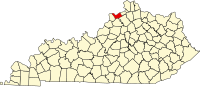 | |
| Unincorporated communities | ||
| Ghost towns | ||
| ||


