National Register of Historic Places listings in Whitley County, Kentucky

This is a list of the National Register of Historic Places listings in Whitley County, Kentucky.
This is intended to be a complete list of the properties and districts on the National Register of Historic Places in Whitley County, Kentucky, United States. The locations of National Register properties and districts for which the latitude and longitude coordinates are included below, may be seen in a map.[1]
There are 13 properties and districts listed on the National Register in the county.
This National Park Service list is complete through NPS recent listings posted September 5, 2024.[2]
Map all coordinates using OpenStreetMap
Download coordinates as:
- KML
- GPX (all coordinates)
- GPX (primary coordinates)
- GPX (secondary coordinates)
Current listings
| [3] | Name on the Register | Image | Date listed[4] | Location | City or town | Description |
|---|---|---|---|---|---|---|
| 1 | Bowman Site (15WH14) | Upload image | November 30, 1985 (#85002974) | Address Restricted | Lot | A Mississippian mound site also known as the "Bowman Mound"[5] |
| 2 | Carnegie Library | 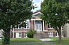 | March 28, 1986 (#86000603) | 400 Roy Kidd Avenue 36°57′01″N 84°05′38″W / 36.950139°N 84.093750°W / 36.950139; -84.093750 (Carnegie Library) | Corbin | |
| 3 | Corbin Bank Building |  | March 28, 1986 (#86000604) | 101 Center St. 36°56′58″N 84°05′49″W / 36.949306°N 84.096806°W / 36.949306; -84.096806 (Corbin Bank Building) | Corbin | |
| 4 | East Main Street Bridge |  | March 28, 1986 (#86000605) | Engineer St. and Lynn Camp Creek 36°57′11″N 84°05′40″W / 36.953111°N 84.094444°W / 36.953111; -84.094444 (East Main Street Bridge) | Corbin | |
| 5 | First Christian Church | 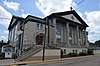 | March 28, 1986 (#86000693) | 100 South Kentucky Avenue 36°56′48″N 84°05′51″W / 36.946667°N 84.097500°W / 36.946667; -84.097500 (First Christian Church) | Corbin | |
| 6 | Dr. Ancil Gatliff House |  | August 11, 1980 (#80001689) | S. 5th St. 36°44′27″N 84°09′41″W / 36.740833°N 84.161389°W / 36.740833; -84.161389 (Dr. Ancil Gatliff House) | Williamsburg | |
| 7 | J.B. Gatliff House | 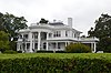 | December 16, 1977 (#77000663) | 10th and Main Sts. 36°44′08″N 84°10′01″W / 36.735556°N 84.166944°W / 36.735556; -84.166944 (J.B. Gatliff House) | Williamsburg | |
| 8 | Gordon Hill Road Historic District |  | March 28, 1986 (#86000692) | 309-501 Gordon Hill Rd. 36°56′53″N 84°06′02″W / 36.948056°N 84.100556°W / 36.948056; -84.100556 (Gordon Hill Road Historic District) | Corbin | |
| 9 | Lane Theater |  | November 26, 2004 (#04001255) | 510 Main St. 36°44′28″N 84°09′43″W / 36.741111°N 84.161944°W / 36.741111; -84.161944 (Lane Theater) | Williamsburg | |
| 10 | Louisville and Nashville Railroad Depot | 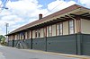 | June 15, 1978 (#78001414) | Lynn Ave. 36°56′51″N 84°05′44″W / 36.947500°N 84.095556°W / 36.947500; -84.095556 (Louisville and Nashville Railroad Depot) | Corbin | |
| 11 | Mershon Building | 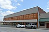 | March 28, 1986 (#86000606) | E. Center St. 36°56′58″N 84°05′46″W / 36.949444°N 84.096111°W / 36.949444; -84.096111 (Mershon Building) | Corbin | |
| 12 | Williamsburg Armory | 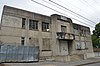 | September 6, 2002 (#02000930) | S. 2nd St. 36°44′13″N 84°09′25″W / 36.736944°N 84.156944°W / 36.736944; -84.156944 (Williamsburg Armory) | Williamsburg | |
| 13 | Williamsburg Historic District | Upload image | April 25, 2019 (#100003683) | Main & Main Cross Sts. Coordinates missing | Williamsburg |
See also
Wikimedia Commons has media related to National Register of Historic Places in Whitley County, Kentucky.
- List of National Historic Landmarks in Kentucky
- National Register of Historic Places listings in Kentucky
References
- ^ The latitude and longitude information provided in this table was derived originally from the National Register Information System, which has been found to be fairly accurate for about 99% of listings. Some locations in this table may have been corrected to current GPS standards.
- ^ National Park Service, United States Department of the Interior, "National Register of Historic Places: Weekly List Actions", retrieved September 5, 2024.
- ^ Numbers represent an alphabetical ordering by significant words. Various colorings, defined here, differentiate National Historic Landmarks and historic districts from other NRHP buildings, structures, sites or objects.
- ^ The eight-digit number below each date is the number assigned to each location in the National Register Information System database, which can be viewed by clicking the number.
- ^ Jefferies, Richard W. "Living on the Edge: Mississippian Settlement in the Cumberland Gap Vicinity". In Archaeology of the Appalachian Highlands: 198-221. Lynne P. Sullivan and Susan C. Prezzano, eds. Knoxville: U of Tennessee P, 2001, 211.
- v
- t
- e
- List of U.S. National Historic Landmarks by state:
- Alabama
- Alaska
- Arizona
- Arkansas
- California
- Colorado
- Connecticut
- Delaware
- Florida
- Georgia
- Hawaii
- Idaho
- Illinois
- Indiana
- Iowa
- Kansas
- Kentucky
- Louisiana
- Maine
- Maryland
- Massachusetts
- Michigan
- Minnesota
- Mississippi
- Missouri
- Montana
- Nebraska
- Nevada
- New Hampshire
- New Jersey
- New Mexico
- New York
- North Carolina
- North Dakota
- Ohio
- Oklahoma
- Oregon
- Pennsylvania
- Rhode Island
- South Carolina
- South Dakota
- Tennessee
- Texas
- Utah
- Vermont
- Virginia
- Washington
- West Virginia
- Wisconsin
- Wyoming
 National Register of Historic Places portal
 Category


Municipalities and communities of Whitley County, Kentucky, United States | ||
|---|---|---|
County seat: Williamsburg | ||
| Cities |  | |
| CDPs | ||
| Other unincorporated communities | ||
| Ghost town | ||
| Footnotes | ‡This populated place also has portions in an adjacent county | |
| ||


