National Register of Historic Places listings in Harnett County, North Carolina
Map all coordinates using OpenStreetMap
Download coordinates as:
- KML
- GPX (all coordinates)
- GPX (primary coordinates)
- GPX (secondary coordinates)

This list includes properties and districts listed on the National Register of Historic Places in Harnett County, North Carolina, United States. Click the "Map of all coordinates" link to the right to view a Google map of all properties and districts with latitude and longitude coordinates in the table below.[1]
Current listings
This National Park Service list is complete through NPS recent listings posted April 12, 2024.[2]
| [3] | Name on the Register[4] | Image | Date listed[5] | Location | City or town | Description |
|---|---|---|---|---|---|---|
| 1 | Averasboro Battlefield Historic District | Upload image | May 10, 2001 (#00001425) | Roughly bounded by Cape Fear R., NC 1780, the Black R., NC 1801 35°15′16″N 78°39′52″W / 35.254444°N 78.664444°W / 35.254444; -78.664444 (Averasboro Battlefield Historic District) | Erwin | |
| 2 | James Archibald Campbell House | Upload image | November 17, 1977 (#77001001) | U.S. 421 35°24′28″N 78°45′00″W / 35.407778°N 78.75°W / 35.407778; -78.75 (James Archibald Campbell House) | Buies Creek | |
| 3 | Dunn Commercial Historic District |  | September 9, 2009 (#09000702) | Roughly Bounded by Harnett St., Cumberland St., Clinton Ave. & Fayetteville Ave. 35°18′30″N 78°36′34″W / 35.308436°N 78.609511°W / 35.308436; -78.609511 (Dunn Commercial Historic District) | Dunn | |
| 4 | Erwin Commercial Historic District | 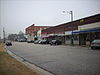 | April 27, 2015 (#15000182) | 100 Denim Drive, 101-127 E. H & 103-111 S. 13th Sts. 35°19′39″N 78°40′33″W / 35.3275°N 78.6759°W / 35.3275; -78.6759 (Erwin Commercial Historic District) | Erwin | |
| 5 | Harnett County Training School |  | August 20, 2014 (#14000521) | 610 E. Johnson St. 35°18′38″N 78°36′02″W / 35.310556°N 78.600556°W / 35.310556; -78.600556 (Harnett County Training School) | Dunn | |
| 6 | Harrington-Dewar House | Upload image | January 23, 2009 (#08001363) | 994 Fred Burns Rd. 35°33′13″N 78°54′38″W / 35.553681°N 78.910447°W / 35.553681; -78.910447 (Harrington-Dewar House) | Holly Springs | |
| 7 | Kenneth L. Howard House |  | August 19, 1982 (#82003465) | 400 S. Layton Ave. 35°18′27″N 78°36′58″W / 35.307500°N 78.616111°W / 35.307500; -78.616111 (Kenneth L. Howard House) | Dunn | |
| 8 | Ivy Burne | Upload image | September 5, 1991 (#91001377) | NC 217, E side 0.4 miles S of jct. with NC 2027 35°15′57″N 78°44′03″W / 35.265833°N 78.734167°W / 35.265833; -78.734167 (Ivy Burne) | Linden | |
| 9 | Johnson Farm | Upload image | April 15, 2010 (#10000207) | 2095 Kipling Rd. (south side SR 1403, .2 miles east of SR 1425) 35°29′17″N 78°51′09″W / 35.488039°N 78.852617°W / 35.488039; -78.852617 (Johnson Farm) | Kipling | |
| 10 | Lebanon | Upload image | January 29, 1973 (#73001351) | 4.5 miles SW of Dunn on NC 82 35°15′35″N 78°40′17″W / 35.259722°N 78.671389°W / 35.259722; -78.671389 (Lebanon) | Dunn | |
| 11 | Gen. William C. Lee House |  | November 25, 1983 (#83003968) | 209 W. Divine St. 35°18′27″N 78°36′50″W / 35.307500°N 78.613889°W / 35.307500; -78.613889 (Gen. William C. Lee House) | Dunn | |
| 12 | Long Valley Farm | Upload image | June 6, 1994 (#94000032) | Address Restricted | Spring Lake | |
| 13 | John A. McKay House and Manufacturing Company |  | April 10, 1986 (#86000739) | 100 E. Divine St. 35°18′23″N 78°37′00″W / 35.306389°N 78.616667°W / 35.306389; -78.616667 (John A. McKay House and Manufacturing Company) | Dunn | |
| 14 | Dr. Wayman C. Melvin House | Upload image | January 9, 2008 (#07001375) | 6386 NC 217 35°16′01″N 78°44′26″W / 35.267033°N 78.740553°W / 35.267033; -78.740553 (Dr. Wayman C. Melvin House) | Linden | |
| 15 | Summer Villa and the McKay-Salmon House |  | April 25, 1985 (#85000902) | SR 1291 35°24′18″N 78°51′54″W / 35.405°N 78.865°W / 35.405; -78.865 (Summer Villa and the McKay-Salmon House) | Lillington | |
| 16 | Summerville Presbyterian Church and Cemetery | 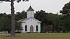 | April 25, 1985 (#85000903) | Off SR 1291 35°24′10″N 78°51′19″W / 35.402778°N 78.855278°W / 35.402778; -78.855278 (Summerville Presbyterian Church and Cemetery) | Lillington | |
| 17 | Thorbiskope | Upload image | January 23, 1986 (#86000132) | Off SR 2049 at SR 2050 35°13′58″N 78°53′51″W / 35.232778°N 78.8975°W / 35.232778; -78.8975 (Thorbiskope) | Bunnlevel | |
| 18 | Williams Grove School | 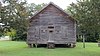 | May 26, 1995 (#95000659) | E. Depot St. N side, between Hickory and Willow Sts. 35°30′27″N 78°44′06″W / 35.5075°N 78.735°W / 35.5075; -78.735 (Williams Grove School) | Angier |
See also
Wikimedia Commons has media related to National Register of Historic Places in Harnett County, North Carolina.
- National Register of Historic Places listings in North Carolina
- List of National Historic Landmarks in North Carolina
References
- ^ The latitude and longitude information provided in this table was derived originally from the National Register Information System, which has been found to be fairly accurate for about 99% of listings. Some locations in this table may have been corrected to current GPS standards.
- ^ National Park Service, United States Department of the Interior, "National Register of Historic Places: Weekly List Actions", retrieved April 12, 2024.
- ^ Numbers represent an alphabetical ordering by significant words. Various colorings, defined here, differentiate National Historic Landmarks and historic districts from other NRHP buildings, structures, sites or objects.
- ^ "National Register Information System". National Register of Historic Places. National Park Service. April 24, 2008.
- ^ The eight-digit number below each date is the number assigned to each location in the National Register Information System database, which can be viewed by clicking the number.
- v
- t
- e

by county
- Alamance
- Alexander
- Alleghany
- Anson
- Ashe
- Avery
- Beaufort
- Bertie
- Bladen
- Brunswick
- Buncombe
- Burke
- Cabarrus
- Caldwell
- Camden
- Carteret
- Caswell
- Catawba
- Chatham
- Cherokee
- Chowan
- Clay
- Cleveland
- Columbus
- Craven
- Cumberland
- Currituck
- Dare
- Davidson
- Davie
- Duplin
- Durham
- Edgecombe
- Forsyth
- Franklin
- Gaston
- Gates
- Graham
- Granville
- Greene
- Guilford
- Halifax
- Harnett
- Haywood
- Henderson
- Hertford
- Hoke
- Hyde
- Iredell
- Jackson
- Johnston
- Jones
- Lee
- Lenoir
- Lincoln
- Macon
- Madison
- Martin
- McDowell
- Mecklenburg
- Mitchell
- Montgomery
- Moore
- Nash
- New Hanover
- Northampton
- Onslow
- Orange
- Pamlico
- Pasquotank
- Pender
- Perquimans
- Person
- Pitt
- Polk
- Randolph
- Richmond
- Robeson
- Rockingham
- Rowan
- Rutherford
- Sampson
- Scotland
- Stanly
- Stokes
- Surry
- Swain
- Transylvania
- Tyrrell
- Union
- Vance
- Wake
- Warren
- Washington
- Watauga
- Wayne
- Wilkes
- Wilson
- Yadkin
- Yancey
| |
|---|---|
| Topics | |
| Lists by state |
|
| Lists by insular areas | |
| Lists by associated state | |
| Other areas | |
| Related | |
| |


