National Register of Historic Places listings in Robeson County, North Carolina
Map all coordinates using OpenStreetMap
Download coordinates as:
- KML
- GPX (all coordinates)
- GPX (primary coordinates)
- GPX (secondary coordinates)

This list includes properties and districts listed on the National Register of Historic Places in Robeson County, North Carolina. Click the "Map of all coordinates" link to the right to view a Google map of all properties and districts with latitude and longitude coordinates in the table below.[1]
Current listings
This National Park Service list is complete through NPS recent listings posted April 12, 2024.[2]
| [3] | Name on the Register[4] | Image | Date listed[5] | Location | City or town | Description |
|---|---|---|---|---|---|---|
| 1 | Asbury Methodist Church |  | April 30, 2009 (#09000264) | Southeast side US 301 N., 0.1 miles (0.16 km) southwest of NC 1154 34°34′29″N 79°11′32″W / 34.574823°N 79.192232°W / 34.574823; -79.192232 (Asbury Methodist Church) | Raynham | |
| 2 | Ashpole Presbyterian Church |  | October 19, 1982 (#82001302) | 192 Ashpole Church Rd.[6] 34°33′00″N 79°18′36″W / 34.549892°N 79.310102°W / 34.549892; -79.310102 (Ashpole Presbyterian Church) | Rowland | |
| 3 | Baker Sanatorium |  | October 8, 1998 (#98001240) | 207 E. 14th Street[7] 34°37′38″N 79°00′25″W / 34.627117°N 79.007048°W / 34.627117; -79.007048 (Baker Sanatorium) | Lumberton | |
| 4 | Luther Henry Caldwell House |  | September 18, 1978 (#78001971) | 209 Caldwell St. 34°37′21″N 79°00′39″W / 34.6225°N 79.010833°W / 34.6225; -79.010833 (Luther Henry Caldwell House) | Lumberton | |
| 5 | Carolina Theatre |  | July 9, 1981 (#81000426) | 319 N. Chestnut St. 34°37′09″N 79°00′28″W / 34.619211°N 79.007865°W / 34.619211; -79.007865 (Carolina Theatre) | Lumberton | |
| 6 | Centenary Methodist Church |  | April 10, 2007 (#07000294) | 2585 NC 130 E, jct. with NC 2462 34°29′33″N 79°15′06″W / 34.4925°N 79.251667°W / 34.4925; -79.251667 (Centenary Methodist Church) | Rowland | |
| 7 | Fairmont Commercial Historic District | Upload image | April 7, 2010 (#10000163) | Bordered roughly by Byrd St. on the north, Walnut St. on the east, Red Cross St. on the south, & Alley St. on the west 34°29′52″N 79°06′48″W / 34.497742°N 79.113372°W / 34.497742; -79.113372 (Fairmont Commercial Historic District) | Fairmont | |
| 8 | Former Pembroke High School | Upload image | September 1, 1995 (#95001071) | East of the junction of Highway 711 and NC 1561 34°41′10″N 79°12′16″W / 34.686111°N 79.204444°W / 34.686111; -79.204444 (Former Pembroke High School) | Pembroke | |
| 9 | Humphrey-Williams Plantation | Upload image | November 16, 1988 (#88002608) | West of Lumberton on NC 211, between SR 1001 and SR 1769 34°42′08″N 79°03′41″W / 34.702222°N 79.061389°W / 34.702222; -79.061389 (Humphrey-Williams Plantation) | Lumberton | Boundaries increased on November 16, 1988; the Greek Revival main house of this plantation was listed as the Humphrey-Williams House, with the boundary increase being the rest of the plantation |
| 10 | Lumberton Commercial Historic District |  | December 21, 1989 (#89002131) | Roughly Sixth St., Elm St., Fifth St., Chestnut St., Second St., Walnut St., Seaboard Coast Railroad tracks, & Water St. 34°37′08″N 79°00′32″W / 34.618889°N 79.008889°W / 34.618889; -79.008889 (Lumberton Commercial Historic District) | Lumberton | |
| 11 | Flora MacDonald College |  | April 3, 1976 (#76001336) | College St. and 2nd Ave. 34°45′41″N 79°10′56″W / 34.761389°N 79.182222°W / 34.761389; -79.182222 (Flora MacDonald College) | Red Springs | |
| 12 | Maxton Historic District |  | February 12, 1999 (#99000199) | Roughly bounded by Graham St., Martin Luther King Dr., McCaskill St., and Florence St. 34°44′15″N 79°20′57″W / 34.7375°N 79.349167°W / 34.7375; -79.349167 (Maxton Historic District) | Maxton | |
| 13 | Kenneth McKinnon House | Upload image | September 15, 2005 (#05001029) | South Side of NC 20, SE corner of NC 20 and NC 1907 34°48′11″N 78°57′01″W / 34.802958°N 78.950411°W / 34.802958; -78.950411 (Kenneth McKinnon House) | St. Pauls | |
| 14 | Old Main, the University of North Carolina at Pembroke | 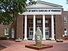 | May 13, 1976 (#76001335) | West of the junction of NC 711 and SR 1340 34°41′06″N 79°12′07″W / 34.685°N 79.201944°W / 34.685; -79.201944 (Old Main, the University of North Carolina at Pembroke) | Pembroke | |
| 15 | Philadelphus Presbyterian Church |  | October 3, 1975 (#75001287) | SR 1318 southwest of the junction with NC 72 34°45′36″N 79°10′16″W / 34.760000°N 79.171194°W / 34.760000; -79.171194 (Philadelphus Presbyterian Church) | Philadelphus | |
| 16 | Planters Building |  | November 3, 1987 (#87001913) | 308 N. Chestnut St.[8] 34°37′09″N 79°00′27″W / 34.619232°N 79.007577°W / 34.619232; -79.007577 (Planters Building) | Lumberton | |
| 17 | Robeson County Agricultural Building |  | April 16, 2012 (#12000216) | 108 W. 8th St. 34°37′22″N 79°00′33″W / 34.622808°N 79.009126°W / 34.622808; -79.009126 (Robeson County Agricultural Building) | Lumberton | |
| 18 | Rowland Depot |  | May 18, 2001 (#01000511) | W. Main St. and W. Railroad St. 34°32′12″N 79°17′35″W / 34.536744°N 79.292922°W / 34.536744; -79.292922 (Rowland Depot) | Rowland | |
| 19 | Rowland Main Street Historic District |  | February 2, 2005 (#04001582) | Roughly bounded by the 100 and 200 blocks of W. Main St., 100 blk of E. Main St., and Hickory and E and W Railroad Sts. 34°32′13″N 79°17′36″W / 34.536944°N 79.293333°W / 34.536944; -79.293333 (Rowland Main Street Historic District) | Rowland | |
| 20 | Alfred Rowland House | 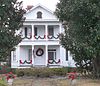 | January 17, 2008 (#07001411) | 1111 Carthage Rd. 34°37′50″N 79°01′03″W / 34.630568°N 79.017602°W / 34.630568; -79.017602 (Alfred Rowland House) | Lumberton | |
| 21 | W.R. Surles Memorial Library |  | September 16, 2009 (#09000725) | 105 W. Main St. 34°28′36″N 79°02′16″W / 34.476557°N 79.037679°W / 34.476557; -79.037679 (W.R. Surles Memorial Library) | Proctorville | |
| 22 | US Post Office-Lumberton | 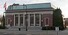 | March 6, 1985 (#85000483) | 606 N. Elm St. 34°37′17″N 79°00′30″W / 34.62142°N 79.008335°W / 34.62142; -79.008335 (US Post Office-Lumberton) | Lumberton | |
| 23 | Williams-Powell House | Upload image | April 9, 1984 (#84002453) | SR 2256 34°22′29″N 79°03′07″W / 34.374722°N 79.051944°W / 34.374722; -79.051944 (Williams-Powell House) | Orrum |
See also
Wikimedia Commons has media related to National Register of Historic Places in Robeson County, North Carolina.
- National Register of Historic Places listings in North Carolina
- List of National Historic Landmarks in North Carolina
References
- ^ The latitude and longitude information provided in this table was derived originally from the National Register Information System, which has been found to be fairly accurate for about 99% of listings. Some locations in this table may have been corrected to current GPS standards.
- ^ National Park Service, United States Department of the Interior, "National Register of Historic Places: Weekly List Actions", retrieved April 12, 2024.
- ^ Numbers represent an alphabetical ordering by significant words. Various colorings, defined here, differentiate National Historic Landmarks and historic districts from other NRHP buildings, structures, sites or objects.
- ^ "National Register Information System". National Register of Historic Places. National Park Service. April 24, 2008.
- ^ The eight-digit number below each date is the number assigned to each location in the National Register Information System database, which can be viewed by clicking the number.
- ^ "Churches". Presbytery of Coastal Carolina. Retrieved 2014-12-24.
- ^ See number over 14th Street entrance in 2014 photo; or see "Baker House", Excel Property Management, retrieved 2014-12-26.
- ^ See number over front door in 2014 photo.
- v
- t
- e

by county
- Alamance
- Alexander
- Alleghany
- Anson
- Ashe
- Avery
- Beaufort
- Bertie
- Bladen
- Brunswick
- Buncombe
- Burke
- Cabarrus
- Caldwell
- Camden
- Carteret
- Caswell
- Catawba
- Chatham
- Cherokee
- Chowan
- Clay
- Cleveland
- Columbus
- Craven
- Cumberland
- Currituck
- Dare
- Davidson
- Davie
- Duplin
- Durham
- Edgecombe
- Forsyth
- Franklin
- Gaston
- Gates
- Graham
- Granville
- Greene
- Guilford
- Halifax
- Harnett
- Haywood
- Henderson
- Hertford
- Hoke
- Hyde
- Iredell
- Jackson
- Johnston
- Jones
- Lee
- Lenoir
- Lincoln
- Macon
- Madison
- Martin
- McDowell
- Mecklenburg
- Mitchell
- Montgomery
- Moore
- Nash
- New Hanover
- Northampton
- Onslow
- Orange
- Pamlico
- Pasquotank
- Pender
- Perquimans
- Person
- Pitt
- Polk
- Randolph
- Richmond
- Robeson
- Rockingham
- Rowan
- Rutherford
- Sampson
- Scotland
- Stanly
- Stokes
- Surry
- Swain
- Transylvania
- Tyrrell
- Union
- Vance
- Wake
- Warren
- Washington
- Watauga
- Wayne
- Wilkes
- Wilson
- Yadkin
- Yancey
| |
|---|---|
| Topics | |
| Lists by state |
|
| Lists by insular areas | |
| Lists by associated state | |
| Other areas | |
| Related | |
| |


