National Register of Historic Places listings in Mitchell County, North Carolina
Map all coordinates using OpenStreetMap
Download coordinates as:
- KML
- GPX (all coordinates)
- GPX (primary coordinates)
- GPX (secondary coordinates)

This list includes properties and districts listed on the National Register of Historic Places in Mitchell County, North Carolina. Click the "Map of all coordinates" link to the right to view a Google map of all properties and districts with latitude and longitude coordinates in the table below.[1]
Current listings
This National Park Service list is complete through NPS recent listings posted April 12, 2024.[2]
| [3] | Name on the Register | Image | Date listed[4] | Location | City or town | Description |
|---|---|---|---|---|---|---|
| 1 | Church of the Resurrection |  | March 5, 1999 (#99000272) | 302 High Ridge Rd. 35°51′03″N 82°05′26″W / 35.850833°N 82.090556°W / 35.850833; -82.090556 (Church of the Resurrection) | Little Switzerland | |
| 2 | Dellinger Mill |  | November 19, 1998 (#98001385) | S side of Cane Creek Rd., just W of jct. with NC 1239 36°01′01″N 82°05′53″W / 36.016944°N 82.098056°W / 36.016944; -82.098056 (Dellinger Mill) | Hawk | |
| 3 | Downtown Spruce Pine Historic District |  | August 28, 2003 (#03000855) | Roughly bounded by Oak Ave., Locust St., Topaz St., and NC 226 35°54′58″N 82°04′12″W / 35.916111°N 82.07°W / 35.916111; -82.07 (Downtown Spruce Pine Historic District) | Spruce Pine | |
| 4 | Gunter Building |  | March 1, 2002 (#02000112) | 288 Oak Ave. 35°54′57″N 82°04′06″W / 35.915833°N 82.068333°W / 35.915833; -82.068333 (Gunter Building) | Spruce Pine | |
| 5 | Mitchell County Courthouse | 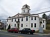 | May 10, 1979 (#79001736) | Main St. 36°00′57″N 82°09′30″W / 36.015833°N 82.158333°W / 36.015833; -82.158333 (Mitchell County Courthouse) | Bakersville | |
| 6 | Penland Post Office and General Store | 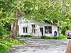 | April 16, 2012 (#12000214) | 1162 Penland Rd. 35°55′48″N 82°06′50″W / 35.930031°N 82.113901°W / 35.930031; -82.113901 (Penland Post Office and General Store) | Penland | |
| 7 | Penland School Historic District |  | December 10, 2003 (#03001270) | NC 1164 (Conley Ridge Rd.) 35°56′26″N 82°07′00″W / 35.940556°N 82.116667°W / 35.940556; -82.116667 (Penland School Historic District) | Penland | |
| 8 | John N. Peterson Farm |  | December 6, 1990 (#90001859) | E side of SR 1321 just N of jct. with SR 1322 36°05′25″N 82°19′48″W / 36.090278°N 82.33°W / 36.090278; -82.33 (John N. Peterson Farm) | Poplar | |
| 9 | Henry Willis House | Upload image | July 14, 1988 (#88001051) | SR 1164 35°56′17″N 82°07′47″W / 35.938056°N 82.129722°W / 35.938056; -82.129722 (Henry Willis House) | Penland |
See also
Wikimedia Commons has media related to National Register of Historic Places in Mitchell County, North Carolina.
- National Register of Historic Places listings in North Carolina
- List of National Historic Landmarks in North Carolina
References
- ^ The latitude and longitude information provided in this table was derived originally from the National Register Information System, which has been found to be fairly accurate for about 99% of listings. Some locations in this table may have been corrected to current GPS standards.
- ^ National Park Service, United States Department of the Interior, "National Register of Historic Places: Weekly List Actions", retrieved April 12, 2024.
- ^ Numbers represent an alphabetical ordering by significant words. Various colorings, defined here, differentiate National Historic Landmarks and historic districts from other NRHP buildings, structures, sites or objects.
- ^ The eight-digit number below each date is the number assigned to each location in the National Register Information System database, which can be viewed by clicking the number.
- v
- t
- e

by county
- Alamance
- Alexander
- Alleghany
- Anson
- Ashe
- Avery
- Beaufort
- Bertie
- Bladen
- Brunswick
- Buncombe
- Burke
- Cabarrus
- Caldwell
- Camden
- Carteret
- Caswell
- Catawba
- Chatham
- Cherokee
- Chowan
- Clay
- Cleveland
- Columbus
- Craven
- Cumberland
- Currituck
- Dare
- Davidson
- Davie
- Duplin
- Durham
- Edgecombe
- Forsyth
- Franklin
- Gaston
- Gates
- Graham
- Granville
- Greene
- Guilford
- Halifax
- Harnett
- Haywood
- Henderson
- Hertford
- Hoke
- Hyde
- Iredell
- Jackson
- Johnston
- Jones
- Lee
- Lenoir
- Lincoln
- Macon
- Madison
- Martin
- McDowell
- Mecklenburg
- Mitchell
- Montgomery
- Moore
- Nash
- New Hanover
- Northampton
- Onslow
- Orange
- Pamlico
- Pasquotank
- Pender
- Perquimans
- Person
- Pitt
- Polk
- Randolph
- Richmond
- Robeson
- Rockingham
- Rowan
- Rutherford
- Sampson
- Scotland
- Stanly
- Stokes
- Surry
- Swain
- Transylvania
- Tyrrell
- Union
- Vance
- Wake
- Warren
- Washington
- Watauga
- Wayne
- Wilkes
- Wilson
- Yadkin
- Yancey
| |
|---|---|
| Topics | |
| Lists by state |
|
| Lists by insular areas | |
| Lists by associated state | |
| Other areas | |
| Related | |
| |


Municipalities and communities of Mitchell County, North Carolina, United States | ||
|---|---|---|
County seat: Bakersville | ||
| Towns |  | |
| Unincorporated communities | ||
| Ghost town | ||
| Footnotes | ‡This populated place also has portions in an adjacent county or counties | |
| ||


