National Register of Historic Places listings in Knox County, Indiana

This is a list of the National Register of Historic Places listings in Knox County, Indiana.
This is intended to be a complete list of the properties and districts on the National Register of Historic Places in Knox County, Indiana, United States. Latitude and longitude coordinates are provided for many National Register properties and districts; these locations may be seen together in a map.[1]
There are 21 properties and districts listed on the National Register in the county, including 1 National Historic Landmark. Another 2 properties were once listed but have been removed.
Properties and districts located in incorporated areas display the name of the municipality, while properties and districts in unincorporated areas display the name of their civil township. Properties and districts split between multiple jurisdictions display the names of all jurisdictions.
This National Park Service list is complete through NPS recent listings posted April 26, 2024.[2]
Map all coordinates using OpenStreetMap
Download coordinates as:
- KML
- GPX (all coordinates)
- GPX (primary coordinates)
- GPX (secondary coordinates)
Current listings
| [3] | Name on the Register[4] | Image | Date listed[5] | Location | City or town | Description |
|---|---|---|---|---|---|---|
| 1 | County Bridge No. 45 |  | September 20, 2006 (#06000856) | Carries County Road 229 over the White River, northeast of Wheatland 38°40′46″N 87°16′23″W / 38.679444°N 87.273000°W / 38.679444; -87.273000 (County Bridge No. 45) | Steen Township | Extends into Daviess County |
| 2 | Enoco Coal Mine | 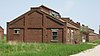 | December 28, 2010 (#10001100) | Northern side of Grundman Rd., 1.5 miles south of Bruceville 38°43′46″N 87°24′50″W / 38.729444°N 87.413889°W / 38.729444; -87.413889 (Enoco Coal Mine) | Washington Township | |
| 3 | Fort Knox II Site |  | March 24, 1982 (#82000045) | 3 miles north of downtown Vincennes[6] 38°43′27″N 87°30′24″W / 38.724167°N 87.506667°W / 38.724167; -87.506667 (Fort Knox II Site) | Vincennes | |
| 4 | George Rogers Clark National Historical Park | 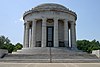 | October 15, 1966 (#66000007) | 401 S. 2nd St., south of U.S. Route 50 38°40′44″N 87°32′07″W / 38.678889°N 87.535278°W / 38.678889; -87.535278 (George Rogers Clark National Historical Park) | Vincennes | |
| 5 | Gregg Park |  | September 25, 2013 (#13000756) | 2204 Washington Ave. 38°41′06″N 87°30′08″W / 38.685000°N 87.502222°W / 38.685000; -87.502222 (Gregg Park) | Vincennes | |
| 6 | Hack and Simon Office Building | 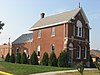 | March 26, 2003 (#03000141) | 1101 N. 3rd St. 38°41′04″N 87°31′14″W / 38.684444°N 87.520694°W / 38.684444; -87.520694 (Hack and Simon Office Building) | Vincennes | |
| 7 | William Henry Harrison Home |  | October 15, 1966 (#66000018) | 3 W. Scott St. 38°41′08″N 87°31′34″W / 38.685556°N 87.526111°W / 38.685556; -87.526111 (William Henry Harrison Home) | Vincennes | |
| 8 | Kimmell Park |  | September 25, 2013 (#13000757) | 2014 Oliphant Dr. 38°41′48″N 87°31′04″W / 38.696667°N 87.517778°W / 38.696667; -87.517778 (Kimmell Park) | Vincennes | |
| 9 | Kixmiller's Store |  | December 8, 1978 (#78000035) | Carlise and Indianapolis Sts. at Freelandville 38°51′54″N 87°18′21″W / 38.865000°N 87.305833°W / 38.865000; -87.305833 (Kixmiller's Store) | Widner Township | |
| 10 | Knox County Poor Asylum | Upload image | December 3, 2018 (#100003183) | 2008 S. Hart Street Rd. 38°38′48″N 87°29′14″W / 38.646667°N 87.487222°W / 38.646667; -87.487222 (Knox County Poor Asylum) | Palmyra Township | |
| 11 | Mont Clair | Upload image | December 27, 2016 (#16000904) | 3890 E. Johnson Farm Rd. 38°39′33″N 87°28′11″W / 38.659100°N 87.469811°W / 38.659100; -87.469811 (Mont Clair) | Vincennes Township | |
| 12 | Andrew Nicholson Farmstead |  | June 17, 2005 (#05000606) | 12095 E. State Road 550, northwest of Wheatland 38°40′08″N 87°19′00″W / 38.668889°N 87.316667°W / 38.668889; -87.316667 (Andrew Nicholson Farmstead) | Steen Township | |
| 13 | Old Cathedral Complex | 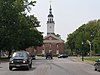 | August 17, 1976 (#76000025) | 205 Church St. 38°40′44″N 87°32′03″W / 38.678889°N 87.534167°W / 38.678889; -87.534167 (Old Cathedral Complex) | Vincennes | |
| 14 | Old State Bank |  | October 9, 1974 (#74000021) | N. 2nd St. 38°40′50″N 87°31′52″W / 38.680667°N 87.531111°W / 38.680667; -87.531111 (Old State Bank) | Vincennes | |
| 15 | Pyramid Mound (12k14) |  | May 12, 1975 (#75000023) | Southern side of Wabash Avenue, southeast of central Vincennes[7] 38°40′14″N 87°30′22″W / 38.670556°N 87.506111°W / 38.670556; -87.506111 (Pyramid Mound (12k14)) | Vincennes | Also known as "Lower Sugarloaf Mound"[8] |
| 16 | Shadowwood |  | June 6, 2001 (#01000618) | 6451 E. Wheatland Rd., east of Vincennes 38°41′59″N 87°25′06″W / 38.699722°N 87.418333°W / 38.699722; -87.418333 (Shadowwood) | Palmyra Township | |
| 17 | Alfred Simonson House |  | December 24, 2009 (#09001131) | 207 Shipping St. 38°48′43″N 87°14′55″W / 38.811806°N 87.248667°W / 38.811806; -87.248667 (Alfred Simonson House) | Edwardsport | |
| 18 | Simpson Nursery Historic District | Upload image | May 24, 2021 (#100006564) | 1502, 1504, 1512 Old Wheatland Rd. 38°41′14″N 87°28′41″W / 38.6872°N 87.4781°W / 38.6872; -87.4781 (Simpson Nursery Historic District) | Vincennes vicinity | |
| 19 | Territorial Capitol of Former Indiana Territory |  | July 2, 1973 (#73000021) | Bounded by Harrison, 1st, Scott, and Park Sts. 38°41′07″N 87°31′31″W / 38.685389°N 87.525167°W / 38.685389; -87.525167 (Territorial Capitol of Former Indiana Territory) | Vincennes | |
| 20 | Vincennes Fortnightly Club |  | September 22, 2000 (#00001133) | 421 N. 6th St. 38°40′45″N 87°31′31″W / 38.679167°N 87.525278°W / 38.679167; -87.525278 (Vincennes Fortnightly Club) | Vincennes | |
| 21 | Vincennes Historic District |  | December 31, 1974 (#74000022) | Vincennes 38°40′41″N 87°31′43″W / 38.678056°N 87.528611°W / 38.678056; -87.528611 (Vincennes Historic District) | Vincennes |
Former listings
| [3] | Name on the Register | Image | Date listed | Date removed | Location | City or town | Description |
|---|---|---|---|---|---|---|---|
| 1 | Ebner-Free House | Upload image | March 21, 1985 (#85000601) | June 2, 1999 | 120 Locust | Vincennes | Moved to a new location in 1999 |
| 2 | Rose Hill Farmstead | 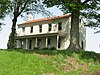 | March 3, 1995 (#95000202) | June 15, 2012 | Old Louisville Rd, 0.25 miles north of its junction with Old Wheatland Rd., and east of Vincennes 38°42′01″N 87°25′11″W / 38.700278°N 87.419722°W / 38.700278; -87.419722 (Rose Hill Farmstead) | Palmyra Township | Demolished in 2011 |
See also
Wikimedia Commons has media related to National Register of Historic Places in Knox County, Indiana.
- List of National Historic Landmarks in Indiana
- National Register of Historic Places listings in Indiana
- Listings in neighboring counties: Crawford (IL), Daviess, Gibson, Greene, Lawrence (IL), Pike, Sullivan, Wabash (IL)
- List of Indiana state historical markers in Knox County
References
- ^ The latitude and longitude information provided in this table was derived originally from the National Register Information System, which has been found to be fairly accurate for about 99% of listings. Some locations in this table may have been corrected to current GPS standards.
- ^ National Park Service, United States Department of the Interior, "National Register of Historic Places: Weekly List Actions", retrieved April 26, 2024.
- ^ a b Numbers represent an alphabetical ordering by significant words. Various colorings, defined here, differentiate National Historic Landmarks and historic districts from other NRHP buildings, structures, sites or objects.
- ^ "National Register Information System". National Register of Historic Places. National Park Service. March 13, 2009.
- ^ The eight-digit number below each date is the number assigned to each location in the National Register Information System database, which can be viewed by clicking the number.
- ^ Address derived from this Vincennes Convention and Visitors' Bureau webpage; coordinates derived from its GNIS feature record. The NRIS lists the site as "Address Restricted".
- ^ Wabash Avenue location derived from this Vincennes Convention and Visitors' Bureau webpage; location and coordinates derived from the GNIS feature record for the "Indian Mound" along Wabash Avenue. The NRIS lists the site as "Address Restricted"
- ^ Attractions Archived 2006-07-31 at the Wayback Machine, City of Vincennes, 2003. Accessed 2009-09-11.
- v
- t
- e
- List of U.S. National Historic Landmarks by state:
- Alabama
- Alaska
- Arizona
- Arkansas
- California
- Colorado
- Connecticut
- Delaware
- Florida
- Georgia
- Hawaii
- Idaho
- Illinois
- Indiana
- Iowa
- Kansas
- Kentucky
- Louisiana
- Maine
- Maryland
- Massachusetts
- Michigan
- Minnesota
- Mississippi
- Missouri
- Montana
- Nebraska
- Nevada
- New Hampshire
- New Jersey
- New Mexico
- New York
- North Carolina
- North Dakota
- Ohio
- Oklahoma
- Oregon
- Pennsylvania
- Rhode Island
- South Carolina
- South Dakota
- Tennessee
- Texas
- Utah
- Vermont
- Virginia
- Washington
- West Virginia
- Wisconsin
- Wyoming
 National Register of Historic Places portal
 Category


