National Register of Historic Places listings in Gibson County, Indiana

This is a list of the National Register of Historic Places listings in Gibson County, Indiana.
This is intended to be a complete list of the properties and districts on the National Register of Historic Places in Gibson County, Indiana, United States. Latitude and longitude coordinates are provided for many National Register properties and districts; these locations may be seen together in a map.[1]
There are 10 properties and districts listed on the National Register in the county.
Properties and districts located in incorporated areas display the name of the municipality, while properties and districts in unincorporated areas display the name of their civil township. Properties and districts split between multiple jurisdictions display the names of all jurisdictions.
This National Park Service list is complete through NPS recent listings posted April 26, 2024.[2]
Map all coordinates using OpenStreetMap
Download coordinates as:
- KML
- GPX (all coordinates)
- GPX (primary coordinates)
- GPX (secondary coordinates)
Current listings
| [3] | Name on the Register[4] | Image | Date listed[5] | Location | City or town | Description |
|---|---|---|---|---|---|---|
| 1 | William M. Cockrum House | 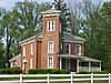 | September 13, 1978 (#78000031) | 627 W. Oak St. 38°20′15″N 87°21′13″W / 38.3375°N 87.353611°W / 38.3375; -87.353611 (William M. Cockrum House) | Oakland City | |
| 2 | Gibson County Courthouse |  | September 27, 1984 (#84001038) | Town Square 38°21′20″N 87°34′05″W / 38.355556°N 87.568056°W / 38.355556; -87.568056 (Gibson County Courthouse) | Princeton | |
| 3 | Haubstadt State Bank |  | December 27, 1984 (#84000489) | 101 S. Main St. 38°12′18″N 87°34′28″W / 38.205°N 87.574444°W / 38.205; -87.574444 (Haubstadt State Bank) | Haubstadt | |
| 4 | Lyles Consolidated School |  | September 9, 1999 (#99001111) | 953 County Rd. 500 W 38°22′11″N 87°39′36″W / 38.369722°N 87.6601°W / 38.369722; -87.6601 (Lyles Consolidated School) | Patoka Township | |
| 5 | Mussel Knoll Archeological Site (12GI11) |  | March 18, 1986 (#86000454) | Along the Wabash River in the middle of Section 14 in far northeastern Wabash Township, west of Skelton[6] 38°20′25″N 87°49′22″W / 38.340278°N 87.822778°W / 38.340278; -87.822778 (Mussel Knoll Archeological Site (12GI11)) | Wabash Township | |
| 6 | Patoka Bridges Historic District |  | March 25, 2005 (#05000198) | Along County Road 1250 E spanning the Patoka River, north of Oakland City[7] 38°22′52″N 87°20′22″W / 38.381042°N 87.339347°W / 38.381042; -87.339347 (Patoka Bridges Historic District) | Columbia Township | Extends into Pike County |
| 7 | Patoka Church of God in Christ-Patoka Colored School | Upload image | November 21, 2022 (#100008411) | 309 South Wood St. 38°24′09″N 87°35′22″W / 38.4024°N 87.5894°W / 38.4024; -87.5894 (Patoka Church of God in Christ-Patoka Colored School) | Patoka | |
| 8 | Trippett-Glaze-Duncan-Kolb Farm |  | May 28, 1993 (#93000470) | State Road 65 east of Patoka; also the Kolb Farm, located along State Road 65 east of Patoka 38°24′15″N 87°31′45″W / 38.404167°N 87.529167°W / 38.404167; -87.529167 (Trippett-Glaze-Duncan-Kolb Farm) | Washington Township | The Kolb Farm represents a boundary increase of December 28, 2009 |
| 9 | Weber Village Archaeological Site (12 Gi 13) |  | September 12, 1985 (#85002131) | North central portion of Section 18, about 0.25 miles (0.40 km) west of Skelton[8] 38°20′36″N 87°47′29″W / 38.343333°N 87.791389°W / 38.343333; -87.791389 (Weber Village Archaeological Site (12 Gi 13)) | Montgomery Township | |
| 10 | Welborn-Ross House |  | March 14, 1996 (#96000287) | 542 S. Hart St. 38°21′01″N 87°34′06″W / 38.350278°N 87.568333°W / 38.350278; -87.568333 (Welborn-Ross House) | Princeton |
See also
Wikimedia Commons has media related to National Register of Historic Places in Gibson County, Indiana.
- List of National Historic Landmarks in Indiana
- National Register of Historic Places listings in Indiana
- Listings in neighboring counties: Edwards (IL), Knox, Pike, Posey, Vanderburgh, Wabash (IL), Warrick, White (IL)
- List of Indiana state historical markers in Gibson County
References
- ^ The latitude and longitude information provided in this table was derived originally from the National Register Information System, which has been found to be fairly accurate for about 99% of listings. Some locations in this table may have been corrected to current GPS standards.
- ^ National Park Service, United States Department of the Interior, "National Register of Historic Places: Weekly List Actions", retrieved April 26, 2024.
- ^ Numbers represent an alphabetical ordering by significant words. Various colorings, defined here, differentiate National Historic Landmarks and historic districts from other NRHP buildings, structures, sites or objects.
- ^ "National Register Information System". National Register of Historic Places. National Park Service. March 13, 2009.
- ^ The eight-digit number below each date is the number assigned to each location in the National Register Information System database, which can be viewed by clicking the number.
- ^ Location derived from Dragoo, Donald. An Archaeological Survey of Gibson County Indiana. Indianapolis: Indiana Historical Bureau, 1955, 12 and 16. The NRIS lists the site as "Address Restricted".
- ^ Location derived from this Indiana Department of Transportation/Federal Highway Administration report, page 6; the NRIS lists the site as "Address Restricted"
- ^ Location derived from Dragoo, Donald. An Archaeological Survey of Gibson County Indiana. Indianapolis: Indiana Historical Bureau, 1955, 18-19. The NRIS lists the site as "Address Restricted".
- v
- t
- e
- List of U.S. National Historic Landmarks by state:
- Alabama
- Alaska
- Arizona
- Arkansas
- California
- Colorado
- Connecticut
- Delaware
- Florida
- Georgia
- Hawaii
- Idaho
- Illinois
- Indiana
- Iowa
- Kansas
- Kentucky
- Louisiana
- Maine
- Maryland
- Massachusetts
- Michigan
- Minnesota
- Mississippi
- Missouri
- Montana
- Nebraska
- Nevada
- New Hampshire
- New Jersey
- New Mexico
- New York
- North Carolina
- North Dakota
- Ohio
- Oklahoma
- Oregon
- Pennsylvania
- Rhode Island
- South Carolina
- South Dakota
- Tennessee
- Texas
- Utah
- Vermont
- Virginia
- Washington
- West Virginia
- Wisconsin
- Wyoming
 National Register of Historic Places portal
 Category


Municipalities and communities of Gibson County, Indiana, United States | ||
|---|---|---|
County seat: Princeton | ||
| Cities |  | |
| Towns | ||
| Townships | ||
| CDPs | ||
| Other communities | ||
| Ghost town | ||
| Footnotes | ‡This populated place also has portions in an adjacent county or counties | |
| ||


