National Register of Historic Places listings in Sullivan County, Indiana

This is a list of the National Register of Historic Places listings in Sullivan County, Indiana.
This is intended to be a complete list of the properties on the National Register of Historic Places in Sullivan County, Indiana, United States. Latitude and longitude coordinates are provided for many National Register properties; these locations may be seen together in a map.[1]
There are 11 properties listed on the National Register in the county.
Properties and districts located in incorporated areas display the name of the municipality, while properties and districts in unincorporated areas display the name of their civil township. Properties and districts split between multiple jurisdictions display the names of all jurisdictions.
This National Park Service list is complete through NPS recent listings posted March 22, 2024.[2]
Map all coordinates using OpenStreetMap
Download coordinates as:
- KML
- GPX (all coordinates)
- GPX (primary coordinates)
- GPX (secondary coordinates)
Current listings
| [3] | Name on the Register[4] | Image | Date listed[5] | Location | City or town | Description |
|---|---|---|---|---|---|---|
| 1 | Center Ridge Cemetery | Upload image | August 8, 2018 (#100002499) | 704 W. Johnson St. 39°05′32″N 87°25′20″W / 39.0922°N 87.4223°W / 39.0922; -87.4223 (Center Ridge Cemetery) | Hamilton Township | |
| 11 | Daugherty-Monroe Archaeological Site (12SU13) | 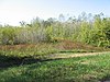 | June 12, 1985 (#85001246) | Northern half of Section 21 Town 8 North Range 11 West[6] 39°07′30″N 87°38′22″W / 39.125000°N 87.639444°W / 39.125000; -87.639444 (Daugherty-Monroe Archaeological Site (12SU13)) | Turman Township | |
| 3 | Merom Site and Fort Azatlan | 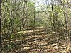 | May 12, 1975 (#75000052) | North of Merom 39°03′45″N 87°34′12″W / 39.062500°N 87.570000°W / 39.062500; -87.570000 (Merom Site and Fort Azatlan) | Gill Township and Merom | |
| 4 | Merom-Gill Township Carnegie Library | Upload image | March 11, 2019 (#100003512) | 8554 Market St. 39°03′23″N 87°33′54″W / 39.0565°N 87.5649°W / 39.0565; -87.5649 (Merom-Gill Township Carnegie Library) | Merom | |
| 5 | Shakamak State Park Historic District |  | March 15, 2000 (#00000199) | 6265 W. State Road 48, west of Jasonville 39°10′35″N 87°14′04″W / 39.176250°N 87.234500°W / 39.176250; -87.234500 (Shakamak State Park Historic District) | Jackson Township | Extends into Clay and Greene counties |
| 6 | Shelburn Interurban Depot-THI&E Interurban Depot |  | December 15, 2015 (#15000890) | 3 N. Railroad St. 39°10′40″N 87°23′39″W / 39.177778°N 87.394028°W / 39.177778; -87.394028 (Shelburn Interurban Depot-THI&E Interurban Depot) | Shelburn | |
| 7 | Sherman Building |  | September 22, 1986 (#86002712) | 2-4 S. Court St. 39°05′43″N 87°24′31″W / 39.095278°N 87.408611°W / 39.095278; -87.408611 (Sherman Building) | Sullivan | |
| 8 | Sullivan County Courthouse |  | December 22, 2008 (#08001213) | 100 Courthouse Square 39°05′42″N 87°24′28″W / 39.094903°N 87.407750°W / 39.094903; -87.407750 (Sullivan County Courthouse) | Sullivan | |
| 9 | Sullivan Courthouse Square Historic District |  | September 4, 2018 (#100002867) | Roughly bounded by Section, Wall, State, and Harris Sts. 39°05′40″N 87°24′30″W / 39.094444°N 87.408333°W / 39.094444; -87.408333 (Sullivan Courthouse Square Historic District) | Sullivan | |
| 10 | Sullivan County Poor Home |  | March 15, 2000 (#00000207) | 1447 County Road 75N, east of Sullivan 39°05′51″N 87°22′57″W / 39.0975°N 87.3825°W / 39.0975; -87.3825 (Sullivan County Poor Home) | Hamilton Township | |
| 2 | Union Christian College | 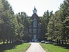 | June 25, 1982 (#82000076) | 3rd and Philip Sts. 39°03′03″N 87°33′53″W / 39.050833°N 87.564722°W / 39.050833; -87.564722 (Union Christian College) | Merom |
See also
Wikimedia Commons has media related to National Register of Historic Places in Sullivan County, Indiana.
- List of National Historic Landmarks in Indiana
- National Register of Historic Places listings in Indiana
- Listings in neighboring counties: Clark (IL), Clay, Crawford (IL), Greene, Knox, Vigo
- List of Indiana state historical markers in Sullivan County
References
- ^ The latitude and longitude information provided in this table was derived originally from the National Register Information System, which has been found to be fairly accurate for about 99% of listings. Some locations in this table may have been corrected to current GPS standards.
- ^ National Park Service, United States Department of the Interior, "National Register of Historic Places: Weekly List Actions", retrieved March 22, 2024.
- ^ Numbers represent an alphabetical ordering by significant words. Various colorings, defined here, differentiate National Historic Landmarks and historic districts from other NRHP buildings, structures, sites or objects.
- ^ "National Register Information System". National Register of Historic Places. National Park Service. March 13, 2009.
- ^ The eight-digit number below each date is the number assigned to each location in the National Register Information System database, which can be viewed by clicking the number.
- ^ Location derived from Clouse, R.O., et al. "Interim Report of the Daughtery-Monroe Site: An Allison-LaMotte Village." Proceedings of the Indiana Academy of Science 80 (1971): 74-83. The NRIS lists the site as "Address Restricted".
- v
- t
- e
- List of U.S. National Historic Landmarks by state:
- Alabama
- Alaska
- Arizona
- Arkansas
- California
- Colorado
- Connecticut
- Delaware
- Florida
- Georgia
- Hawaii
- Idaho
- Illinois
- Indiana
- Iowa
- Kansas
- Kentucky
- Louisiana
- Maine
- Maryland
- Massachusetts
- Michigan
- Minnesota
- Mississippi
- Missouri
- Montana
- Nebraska
- Nevada
- New Hampshire
- New Jersey
- New Mexico
- New York
- North Carolina
- North Dakota
- Ohio
- Oklahoma
- Oregon
- Pennsylvania
- Rhode Island
- South Carolina
- South Dakota
- Tennessee
- Texas
- Utah
- Vermont
- Virginia
- Washington
- West Virginia
- Wisconsin
- Wyoming
 National Register of Historic Places portal
 Category


Municipalities and communities of Sullivan County, Indiana, United States | ||
|---|---|---|
County seat: Sullivan | ||
| Cities |  | |
| Towns | ||
| Townships | ||
| CDPs | ||
| Other communities | ||
| Ghost towns | ||
| Footnotes | ‡This populated place also has portions in an adjacent county or counties | |
| ||


