National Register of Historic Places listings in Lexington, Massachusetts

This is a listing of places in Lexington, Middlesex County, in the U.S. state of Massachusetts, that are listed in the National Register of Historic Places.
Map all coordinates using OpenStreetMap
Download coordinates as:
- KML
- GPX (all coordinates)
- GPX (primary coordinates)
- GPX (secondary coordinates)
| Barnstable | Berkshire | Bristol | Dukes | Essex | Franklin | Hampden | Hampshire | Middlesex | Nantucket | Norfolk | Plymouth | Suffolk | Worcester |
This National Park Service list is complete through NPS recent listings posted March 22, 2024.[1]
Current listings
| [2] | Name on the Register | Image | Date listed[3] | Location | Description |
|---|---|---|---|---|---|
| 1 | Buckman Tavern |  | October 15, 1966 (#66000137) | Hancock St., on the eastern side of Lexington Green 42°26′57″N 71°13′49″W / 42.449167°N 71.230278°W / 42.449167; -71.230278 (Buckman Tavern) | National Historic Landmark |
| 2 | Gen. Samuel Chandler House |  | April 13, 1977 (#77000176) | 8 Goodwin Rd. 42°27′04″N 71°13′45″W / 42.451111°N 71.229167°W / 42.451111; -71.229167 (Gen. Samuel Chandler House) | |
| 3 | Follen Community Church |  | April 30, 1976 (#76000242) | 755 Massachusetts Ave. 42°25′47″N 71°12′27″W / 42.429722°N 71.2075°W / 42.429722; -71.2075 (Follen Community Church) | |
| 4 | Franklin School |  | September 25, 2009 (#09000437) | 7 Stedman Rd. 42°25′41″N 71°13′46″W / 42.427922°N 71.229367°W / 42.427922; -71.229367 (Franklin School) | |
| 5 | Hancock School |  | August 22, 1975 (#75000261) | 33 Forest St. 42°26′50″N 71°13′56″W / 42.447222°N 71.232222°W / 42.447222; -71.232222 (Hancock School) | |
| 6 | Hancock-Clarke House |  | July 17, 1971 (#71000895) | 36 Hancock St. 42°27′13″N 71°13′43″W / 42.453556°N 71.228556°W / 42.453556; -71.228556 (Hancock-Clarke House) | National Historic Landmark |
| 7 | Lexington Green |  | October 15, 1966 (#66000767) | Massachusetts and Hancock Sts. 42°26′58″N 71°13′53″W / 42.449444°N 71.231389°W / 42.449444; -71.231389 (Lexington Green) | National Historic Landmark |
| 8 | John Mason House |  | March 9, 1990 (#90000172) | 1303 Massachusetts Ave. 42°26′28″N 71°12′54″W / 42.441111°N 71.215°W / 42.441111; -71.215 (John Mason House) | |
| 9 | M.H. Merriam and Company |  | February 18, 2009 (#09000033) | 7–9 Oakland St. 42°26′56″N 71°13′37″W / 42.448906°N 71.227033°W / 42.448906; -71.227033 (M.H. Merriam and Company) | |
| 10 | Metropolitan State Hospital |  | January 21, 1994 (#93001482) | 475 Trapelo Rd. 42°24′14″N 71°12′40″W / 42.403889°N 71.211111°W / 42.403889; -71.211111 (Metropolitan State Hospital) | Extends into Belmont and Waltham |
| 11 | Peacock Farm Historic District | 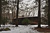 | November 21, 2012 (#12000949) | 1-6 Compton Cir., 1-5 Mason St., 2-53 Peacock Farm Rd., 4-17 Trotting Horse Dr. 42°25′15″N 71°12′13″W / 42.4208°N 71.2035°W / 42.4208; -71.2035 (Peacock Farm Historic District) | |
| 12 | Sanderson House and Munroe Tavern |  | April 26, 1976 (#76000248) | 1314 and 1332 Massachusetts Ave. 42°26′30″N 71°13′00″W / 42.441667°N 71.216667°W / 42.441667; -71.216667 (Sanderson House and Munroe Tavern) | |
| 13 | Warren E. Sherburne House | 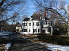 | December 2, 1977 (#77000178) | 11 Percy Rd. 42°26′32″N 71°13′13″W / 42.442222°N 71.220278°W / 42.442222; -71.220278 (Warren E. Sherburne House) | |
| 14 | Simonds Tavern |  | October 14, 1976 (#76000251) | 331 Bedford St. 42°28′03″N 71°14′36″W / 42.4675°N 71.243333°W / 42.4675; -71.243333 (Simonds Tavern) | |
| 15 | Six Moon Hill Historic District |  | January 19, 2016 (#15000981) | 4, 8 Bird Hill & 1-40 Moon Hill Rds, 16, 24 Swan Ln. 42°25′23″N 71°12′42″W / 42.423055°N 71.211536°W / 42.423055; -71.211536 (Six Moon Hill Historic District) | |
| 16 | Stone Building |  | April 30, 1976 (#76000252) | 735 Massachusetts Ave. 42°25′46″N 71°12′26″W / 42.429444°N 71.207222°W / 42.429444; -71.207222 (Stone Building) | |
| 17 | US Post Office-Lexington Main |  | June 26, 1986 (#86001377) | 1661 Massachusetts Ave. 42°26′49″N 71°13′32″W / 42.446944°N 71.225556°W / 42.446944; -71.225556 (US Post Office-Lexington Main) |
References
Wikimedia Commons has media related to National Register of Historic Places in Lexington, Massachusetts.
- ^ National Park Service, United States Department of the Interior, "National Register of Historic Places: Weekly List Actions", retrieved March 22, 2024.
- ^ Numbers represent an alphabetical ordering by significant words. Various colorings, defined here, differentiate National Historic Landmarks and historic districts from other NRHP buildings, structures, sites or objects.
- ^ The eight-digit number below each date is the number assigned to each location in the National Register Information System database, which can be viewed by clicking the number.
- v
- t
- e

| Barnstable County | |
|---|---|
| Bristol County | |
| Essex County | |
| Hampden County | |
| Middlesex County | |
| Norfolk County | |
| Suffolk County | |
| Worcester County |
 Category
 National Register of Historic Places portal
 United States portal


