Municipality in Southeast, Brazil
Flag

Coat of arms
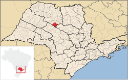 Location in São Paulo state |
| 21°20′08″S 49°13′15″W / 21.33556°S 49.22083°W / -21.33556; -49.22083 |
| Country |  Brazil Brazil |
|---|
| Region | Southeast |
|---|
| State | São Paulo |
|---|
| Mesoregion | São José do Rio Preto |
|---|
| Microregion | Novo Horizonte |
|---|
| Government |
|---|
| • Mayor | Fabiano de Mello Belentani |
|---|
| Area |
|---|
| • Total | 931.7 km2 (359.7 sq mi) |
|---|
| Population |
|---|
| • Total | 41,414 |
|---|
| • Density | 44/km2 (120/sq mi) |
|---|
| Time zone | UTC−3 (BRT) |
|---|
| Postal code | 14960-000 |
|---|
| Area code | +55 17 |
|---|
| Website | www.novohorizonte.sp.gov.br |
|---|
Novo Horizonte (Portuguese for "New Horizon") is a municipality in the state of São Paulo, Brazil. The population is 41,414 (2020 est.) in an area of 932 km2.[2] Novo Horizonte is the center of a Microregion with 79,222 inhabitants.
History
In 1906, the district of Novo Horizonte was created. The city was officially established on December 21, 1916, and installed on October 28, 1917.[3]
Economy
The Tertiary sector is the economic basis of Novo Horizonte. Commerce, services and public administration corresponds to 69.9% of the city GDP. Industry is 21.5% of the GDP, and the Primary sector corresponds to 8.5%.[4]
The cultivation and processing of sugarcane is relevant.
Sport
Grêmio Novorizontino is the local association football club founded in 2010. It's the spiritual successor to Grêmio Esportivo Novorizontino which folded in 1999.
References
- ^ IBGE 2020
- ^ Instituto Brasileiro de Geografia e Estatística
- ^ "History of the City". Novohorizonte.sp.gov.br. Archived from the original on 27 March 2012. Retrieved 15 July 2011.
- ^ "Municipal Profile at SEADE". SEADE.gov.br. Archived from the original on 23 August 2011. Retrieved 15 July 2011.
State of São Paulo, Brazil
|
|
|
|---|
| Capital | |
|---|
| 1,000,000+ | |
|---|
| 500,000+ | |
|---|
| 200,000+ | |
|---|
| 100,000+ | |
|---|
|
|
|
|---|
São José do Rio Preto |
|---|
| Auriflama | |
|---|
| Catanduva | |
|---|
| Fernandópolis | |
|---|
| Jales | |
|---|
| Nhandeara | |
|---|
| Novo Horizonte | |
|---|
| São José do Rio Preto | |
|---|
| Votuporanga | |
|---|
|
|
|
|
|---|
|
Araçatuba |
|---|
| Andradina | |
|---|
| Araçatuba | |
|---|
| Birigui | |
|---|
|
| |
|
|
Bauru |
|---|
| Avaré | |
|---|
| Bauru | |
|---|
| Botucatu | |
|---|
| Jaú | |
|---|
| Lins | |
|---|
|
|
Campinas |
|---|
| Amparo | |
|---|
| Campinas | |
|---|
| Mogi Mirim | |
|---|
| Pirassununga | |
|---|
| São João da Boa Vista | |
|---|
|
|
Itapetininga |
|---|
| Capão Bonito | |
|---|
| Itapetininga | |
|---|
| Itapeva | |
|---|
| Tatuí | |
|---|
|
|
|
Macro Metropolitana Paulista |
|---|
| Bragança Paulista | |
|---|
| Jundiaí | |
|---|
| Piedade | |
|---|
| Sorocaba | |
|---|
|
|
|
Metropolitana de São Paulo |
|---|
| Franco da Rocha | |
|---|
| Guarulhos | |
|---|
| Itapecerica da Serra | |
|---|
| Mogi das Cruzes | |
|---|
| Osasco | |
|---|
| Santos | |
|---|
| São Paulo | |
|---|
|
|
Piracicaba |
|---|
| Limeira | |
|---|
| Piracicaba | |
|---|
| Rio Claro | |
|---|
|
|
Presidente Prudente |
|---|
| Adamantina | |
|---|
| Dracena | |
|---|
| Presidente Prudente | |
|---|
|
|
Ribeirão Preto |
|---|
| Barretos | |
|---|
| Batatais | |
|---|
| Franca | |
|---|
| Ituverava | |
|---|
| Jaboticabal | |
|---|
| Ribeirão Preto | |
|---|
| São Joaquim da Barra | |
|---|
|
|
São José do Rio Preto |
|---|
| Auriflama | |
|---|
| Catanduva | |
|---|
| Fernandópolis | |
|---|
| Jales | |
|---|
| Nhandeara | |
|---|
| Novo Horizonte | |
|---|
| São José do Rio Preto | |
|---|
| Votuporanga | |
|---|
|
|
Vale do Paraíba Paulista |
|---|
| Bananal | |
|---|
| Campos do Jordão | |
|---|
| Caraguatatuba | |
|---|
| Guaratinguetá | |
|---|
| Paraibuna/Paraitinga | |
|---|
| São José dos Campos | |
|---|
|
|
 | This geographical article relating to the state of São Paulo is a stub. You can help Wikipedia by expanding it. |


 Brazil


