Oloron-Sainte-Marie
Subprefecture of Pyrénées-Atlantiques, Nouvelle-Aquitaine
You can help expand this article with text translated from the corresponding article in French. (January 2022) Click [show] for important translation instructions.
- Machine translation, like DeepL or Google Translate, is a useful starting point for translations, but translators must revise errors as necessary and confirm that the translation is accurate, rather than simply copy-pasting machine-translated text into the English Wikipedia.
- Consider adding a topic to this template: there are already 6,170 articles in the main category, and specifying
|topic=will aid in categorization. - Do not translate text that appears unreliable or low-quality. If possible, verify the text with references provided in the foreign-language article.
- You must provide copyright attribution in the edit summary accompanying your translation by providing an interlanguage link to the source of your translation. A model attribution edit summary is
Content in this edit is translated from the existing French Wikipedia article at [[:fr:Oloron-Sainte-Marie]]; see its history for attribution. - You may also add the template
{{Translated|fr|Oloron-Sainte-Marie}}to the talk page. - For more guidance, see Wikipedia:Translation.
Subprefecture and commune in Nouvelle-Aquitaine, France

Coat of arms
Location of Oloron-Sainte-Marie

(2020–2026) Bernard Uthurry[1]
1
(2021)[2]
64422 /64400
(avg. 220 m or 720 ft)
Oloron-Sainte-Marie (French pronunciation: [ɔlɔʁɔ̃ sɛ̃t maʁi] ⓘ; Occitan: Auloron e Senta Maria; Basque: Oloroe-Donamaria) is a commune in the southwestern French department of Pyrénées-Atlantiques.[3]
History
The town was founded by the Romans in the 1st century, then known as Illoronensium.[4] Situated on the Roman way between the important towns of Dax and Saragossa, its position was strategic. Today known as Saint-Grat, Gratus of Oloron became in 506 the first known archbishop of the Ancient Diocese of Oloron then known as "Iluro".
The history of the town during the Migration Period is little known. In 1080, the viscount Centule V, Viscount of Béarn built the new city of "Oloron" (medieval version of the Roman name Iluro) on the opposite side of the river from the diocese center. Centule V restored the Roman walls and founded the strong city of Oloron that was to be used as a base to retake Aragon held by the Moors. The Oloron Cathedral was built at the beginning of the 12th century. The viscountal town of Oloron and the episcopal town of Sainte-Marie were then rivals, but Oloron strove on its textile industry and commerce with neighbouring Spain. Sainte-Marie became economically dependent upon Oloron.
The 18th century was the beginning of revival for Sainte-Marie as the end of French Wars of Religion allowed for restorations and new religious constructions in the town : cathedral, seminary, church Saint-Pierre. Moreover, the continued boom of commerce with Spain accelerated the construction of better communication and transportation routes to Oloron and Sainte-Marie.
With the French Revolution, Oloron lost its diocese to Bayonne but gained administrative importance by becoming one of the sous-préfectures of the new Republic. In 1858, the regent Impress Eugénie imposed the reunification of the towns of Oloron and Sainte-Marie.
Geography
Location
Situated at the feet of the Pyrénées, 50 km from the Spanish border and 100 km from the Atlantic ocean, Oloron-Sainte-Marie is at the confluence of two torrents (gaves), the Gave d'Aspe and the Gave d'Ossau, that merge to form the Gave d'Oloron. Capital of the Haut-Béarn, Oloron-Sainte-Marie is also at the point of origin of the three Haut-Béarn valleys : the Aspe Valley, the Ossau Valley and the Barétous Valley.
Neighboring communes: Esquiule, Moumour, Ledeuix, Estos, Cardesse, Monein, Goès, Précilhon, Escout, Herrère, Ogeu-les-Bains, Buziet, Arudy, Escot, Asasp-Arros, Lurbe-Saint-Christau, Eysus, Gurmençon, Bidos, Agnos, Ance and Féas.
Climate
The town has an oceanic climate, with mild and humid winters and cool or moderately warm summers. Rain is quite abundant (above 900 mm per year) and is mostly concentrated during cold season.
Population
Graphs are unavailable due to technical issues. There is more info on Phabricator and on MediaWiki.org. |
| Year | Pop. | ±% p.a. |
|---|---|---|
| 1968 | 13,028 | — |
| 1975 | 12,332 | −0.78% |
| 1982 | 11,513 | −0.98% |
| 1990 | 11,067 | −0.49% |
| 1999 | 10,992 | −0.08% |
| 2007 | 11,141 | +0.17% |
| 2012 | 10,678 | −0.85% |
| 2017 | 10,684 | +0.01% |
| Source: INSEE[5] | ||
Economy
The Oloron economy is dominated by two well known manufacturing businesses:
- * Lindt & Sprüngli have a chocolate factory in Oloron.
- * Safran Landing Systems have a plant in the adjacent commune of Bidos which manufactures landing gear for aircraft.
Oloron is also famous, among hat enthusiasts, as the capital of the basque beret, although the beret business has fallen victim to the widespread collapse of the European textile business as well as changing fashions. Today only one beret business survives in Oloron. This is the Béatex company which employs approximately 80 people.
The area also benefits from an active agriculture sector, involving animal rearing and general agriculture as well as maize production. It is also part of the AOC defined districts entitled to produce the ewes' cheese, Ossau-Iraty.
Transport
The Pau–Canfranc railway passes through Oloron. Oloron railway station is served by TER Aquitaine, which operate eight trains per day to Pau and six to Bedous.
Public transport in the town is provided by a company called La Navette, which operate three bus routes.
Oloron - Herrère Aérodrome is an aerodrome five kilometers southeast of Oloron. It is predominantly used for light aviation and leisure.
Culture and heritage
Language
The local vernacular language is the Béarnese dialect, a dialect of Gascon language. One of the eight primary schools of Oloron is a Calandreta, a French/ Béarnese bilingual school.
The demonym corresponding to Oloron-Sainte-Marie is Oloronais.[6]
Architectural and historical landmarks

The town received the label French Towns and Lands of Art and History in November 2006.
Oloron's architectural and historical landmarks :
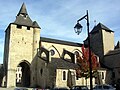
- the 13th-century Tour de Grède
- the former town hall and prison, classified in 1987 among as Monument historique
- the fortified walls
- the 16th-century Legugnon castle
- the 17th-century building in the rue Pomone, classified in 1943 as Monument historique
- the Parc Pommé
- the "Maison du Patrimoine"
- the Médiathèque public library that was awarded the Équerre d'Argent architectural award in 2010 (architect : Pascale Guédot).
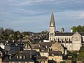
- the Oloron Cathedral
- the Sainte Marie church
-
 Tour de Grède
 -
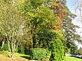 Parc Pommé
 -
 Cathedral Sainte Marie
 -
 Eglise Notre Dame
 -
 Cathedral Sainte Marie
 -
 Saint Great


![]() Media related to Oloron-Sainte-Marie at Wikimedia Commons
Media related to Oloron-Sainte-Marie at Wikimedia Commons
Cultural life
Oloron is home to a number of festivals :
- the jazz festival Des Rives & Notes on the first weekend of July,
- the "Amateur web film festival", organised every spring season to showcase the best short films published on the internet,
- the "Book without borders" fair held on the second weekend of June.
Oloron-Sainte-Marie has a theatre and concert venue (espace Pierre Jéliote).
Gastronomy
The town is renowned for its hearty vegetables, beans and meat soup, the garbure, for the Ossau-Iraty cheese, and for a delicacy invented by a local baker in 1925, the pastry "le Russe".
Notable people
Oloron-Sainte-Marie was the birthplace of:
- Louis Barthou (1862–1934), politician of the Third Republic
- Jean-Jacques Caux (Cataline) (1830–1922), explorer of the Canadian West
- Suzanne Honoré (1909-2000), archivist at the National Library of France
- Ketty Lapeyrette (1884–1960), opera singer
- Camille Lopez (born 1989), rugby player
See also
- Oloron Cathedral
- Gave d'Oloron
- Gave d'Ossau
- Gave d'Aspe
- Ancient Diocese of Oloron
- Communes of the Pyrénées-Atlantiques department
References
- ^ "Répertoire national des élus: les maires" (in French). data.gouv.fr, Plateforme ouverte des données publiques françaises. 13 September 2022.
- ^ "Populations légales 2021". The National Institute of Statistics and Economic Studies. 28 December 2023.
- ^ INSEE commune file
- ^ El euskera arcaico: extensión y parentescos, pag. 141
- ^ Population en historique depuis 1968, INSEE
- ^ "Le nom des habitants de Pyrénées-Atlantiques". Habitants.fr.
Wikimedia Commons has media related to Oloron-Sainte-Marie.
- v
- t
- e

- Aast
- Abère
- Abidos
- Abitain
- Abos
- Accous
- Agnos
- Ahaxe-Alciette-Bascassan
- Ahetze
- Aïcirits-Camou-Suhast
- Aincille
- Ainharp
- Ainhice-Mongelos
- Ainhoa
- Alçay-Alçabéhéty-Sunharette
- Aldudes
- Alos-Sibas-Abense
- Amendeuix-Oneix
- Amorots-Succos
- Ance Féas
- Andoins
- Andrein
- Angaïs
- Anglet
- Angous
- Anhaux
- Anos
- Anoye
- Aramits
- Arancou
- Araujuzon
- Araux
- Arbérats-Sillègue
- Arbonne
- Arbouet-Sussaute
- Arbus
- Arcangues
- Aren
- Aressy
- Arette
- Argagnon
- Argelos
- Arget
- Arhansus
- Armendarits
- Arnéguy
- Arnos
- Aroue-Ithorots-Olhaïby
- Arrast-Larrebieu
- Arraute-Charritte
- Arricau-Bordes
- Arrien
- Arros-de-Nay
- Arrosès
- Arthez-d'Asson
- Arthez-de-Béarn
- Artigueloutan
- Artiguelouve
- Artix
- Arudy
- Arzacq-Arraziguet
- Asasp-Arros
- Ascain
- Ascarat
- Assat
- Asson
- Aste-Béon
- Astis
- Athos-Aspis
- Aubertin
- Aubin
- Aubous
- Audaux
- Auga
- Auriac
- Aurions-Idernes
- Aussevielle
- Aussurucq
- Auterrive
- Autevielle-Saint-Martin-Bideren
- Aydie
- Aydius
- Ayherre
- Baigts-de-Béarn
- Balansun
- Baleix
- Baliracq-Maumusson
- Baliros
- Banca
- Barcus
- Bardos
- Barinque
- Barraute-Camu
- Barzun
- Bassillon-Vauzé
- Bassussarry
- Bastanès
- La Bastide-Clairence
- Baudreix
- Bayonnesubpr
- Bédeille
- Bedous
- Béguios
- Béhasque-Lapiste
- Béhorléguy
- Bellocq
- Bénéjacq
- Bentayou-Sérée
- Béost
- Bérenx
- Bergouey-Viellenave
- Bernadets
- Berrogain-Laruns
- Bescat
- Bésingrand
- Bétracq
- Beuste
- Beyrie-en-Béarn
- Beyrie-sur-Joyeuse
- Biarritz
- Bidache
- Bidarray
- Bidart
- Bidos
- Bielle
- Bilhères
- Billère
- Biriatou
- Biron
- Bizanos
- Boeil-Bezing
- Bonloc
- Bonnut
- Borce
- Bordères
- Bordes
- Bosdarros
- Boucau
- Boueilh-Boueilho-Lasque
- Bougarber
- Bouillon
- Boumourt
- Bourdettes
- Bournos
- Briscous
- Bruges-Capbis-Mifaget
- Bugnein
- Bunus
- Burgaronne
- Buros
- Burosse-Mendousse
- Bussunarits-Sarrasquette
- Bustince-Iriberry
- Buziet
- Buzy
- Cabidos
- Cadillon
- Cambo-les-Bains
- Came
- Camou-Cihigue
- Cardesse
- Çaro
- Carrère
- Carresse-Cassaber
- Castagnède
- Casteide-Cami
- Casteide-Candau
- Casteide-Doat
- Castéra-Loubix
- Castet
- Castetbon
- Castétis
- Castetnau-Camblong
- Castetner
- Castetpugon
- Castillon-d'Arthez
- Castillon-de-Lembeye
- Caubios-Loos
- Cescau
- Cette-Eygun
- Charre
- Charritte-de-Bas
- Chéraute
- Ciboure
- Claracq
- Coarraze
- Conchez-de-Béarn
- Corbère-Abères
- Coslédaà-Lube-Boast
- Coublucq
- Crouseilles
- Cuqueron
- Denguin
- Diusse
- Doazon
- Dognen
- Domezain-Berraute
- Doumy
- Eaux-Bonnes
- Escos
- Escot
- Escou
- Escoubès
- Escout
- Escurès
- Eslourenties-Daban
- Espéchède
- Espelette
- Espès-Undurein
- Espiute
- Espoey
- Esquiule
- Estérençuby
- Estialescq
- Estos
- Etcharry
- Etchebar
- Etsaut
- Eysus
- Fichous-Riumayou
- Gabaston
- Gabat
- Gamarthe
- Gan
- Garindein
- Garlède-Mondebat
- Garlin
- Garos
- Garris
- Gayon
- Gelos
- Ger
- Gerderest
- Gère-Bélesten
- Géronce
- Gestas
- Géus-d'Arzacq
- Geüs-d'Oloron
- Goès
- Gomer
- Gotein-Libarrenx
- Guéthary
- Guiche
- Guinarthe-Parenties
- Gurmençon
- Gurs
- Hagetaubin
- Halsou
- Hasparren
- Haut-de-Bosdarros
- Haux
- Hélette
- Hendaye
- Herrère
- Higuères-Souye
- L'Hôpital-d'Orion
- L'Hôpital-Saint-Blaise
- Hosta
- Hours
- Ibarrolle
- Idaux-Mendy
- Idron
- Igon
- Iholdy
- Ilharre
- Irissarry
- Irouléguy
- Ispoure
- Issor
- Isturits
- Itxassou
- Izeste
- Jasses
- Jatxou
- Jaxu
- Jurançon
- Juxue
- Laà-Mondrans
- Laàs
- Labastide-Cézéracq
- Labastide-Monréjeau
- Labastide-Villefranche
- Labatmale
- Labatut-Figuières
- Labets-Biscay
- Labeyrie
- Lacadée
- Lacarre
- Lacarry-Arhan-Charritte-de-Haut
- Lacommande
- Lacq
- Lagor
- Lagos
- Laguinge-Restoue
- Lahonce
- Lahontan
- Lahourcade
- Lalongue
- Lalonquette
- Lamayou
- Lanne-en-Barétous
- Lannecaube
- Lanneplaà
- Lantabat
- Larceveau-Arros-Cibits
- Laroin
- Larrau
- Larressore
- Larreule
- Larribar-Sorhapuru
- Laruns
- Lasclaveries
- Lasse
- Lasserre
- Lasseube
- Lasseubetat
- Lay-Lamidou
- Lecumberry
- Ledeuix
- Lée
- Lées-Athas
- Lembeye
- Lème
- Léren
- Lescar
- Lescun
- Lespielle
- Lespourcy
- Lestelle-Bétharram
- Lichans-Sunhar
- Lichos
- Licq-Athérey
- Limendous
- Livron
- Lohitzun-Oyhercq
- Lombia
- Lonçon
- Lons
- Loubieng
- Louhossoa
- Lourdios-Ichère
- Lourenties
- Louvie-Juzon
- Louvie-Soubiron
- Louvigny
- Luc-Armau
- Lucarré
- Lucgarier
- Lucq-de-Béarn
- Lurbe-Saint-Christau
- Lussagnet-Lusson
- Luxe-Sumberraute
- Lys
- Macaye
- Malaussanne
- Mascaraàs-Haron
- Maslacq
- Masparraute
- Maspie-Lalonquère-Juillacq
- Maucor
- Mauléon-Licharre
- Maure
- Mazères-Lezons
- Mazerolles
- Méharin
- Meillon
- Mendionde
- Menditte
- Mendive
- Méracq
- Méritein
- Mesplède
- Mialos
- Miossens-Lanusse
- Mirepeix
- Momas
- Momy
- Monassut-Audiracq
- Moncaup
- Moncayolle-Larrory-Mendibieu
- Moncla
- Monein
- Monpezat
- Monségur
- Mont
- Montagut
- Montaner
- Montardon
- Montaut
- Mont-Disse
- Montfort
- Montory
- Morlaàs
- Morlanne
- Mouguerre
- Mouhous
- Moumour
- Mourenx
- Musculdy
- Nabas
- Narcastet
- Narp
- Navailles-Angos
- Navarrenx
- Nay
- Noguères
- Nousty
- Ogenne-Camptort
- Ogeu-les-Bains
- Oloron-Sainte-Mariesubpr
- Oraàs
- Ordiarp
- Orègue
- Orin
- Orion
- Orriule
- Orsanco
- Orthez
- Os-Marsillon
- Ossas-Suhare
- Osse-en-Aspe
- Ossenx
- Osserain-Rivareyte
- Ossès
- Ostabat-Asme
- Ouillon
- Ousse
- Ozenx-Montestrucq
- Pagolle
- Parbayse
- Pardies
- Pardies-Piétat
- Paupref
- Peyrelongue-Abos
- Piets-Plasence-Moustrou
- Poey-de-Lescar
- Poey-d'Oloron
- Pomps
- Ponson-Debat-Pouts
- Ponson-Dessus
- Pontacq
- Pontiacq-Viellepinte
- Portet
- Pouliacq
- Poursiugues-Boucoue
- Préchacq-Josbaig
- Préchacq-Navarrenx
- Précilhon
- Puyoô
- Ramous
- Rébénacq
- Ribarrouy
- Riupeyrous
- Rivehaute
- Rontignon
- Roquiague
- Saint-Abit
- Saint-Armou
- Saint-Boès
- Saint-Castin
- Saint-Dos
- Sainte-Colome
- Sainte-Engrâce
- Saint-Esteben
- Saint-Étienne-de-Baïgorry
- Saint-Faust
- Saint-Girons-en-Béarn
- Saint-Gladie-Arrive-Munein
- Saint-Goin
- Saint-Jammes
- Saint-Jean-de-Luz
- Saint-Jean-le-Vieux
- Saint-Jean-Pied-de-Port
- Saint-Jean-Poudge
- Saint-Just-Ibarre
- Saint-Laurent-Bretagne
- Saint-Martin-d'Arberoue
- Saint-Martin-d'Arrossa
- Saint-Médard
- Saint-Michel
- Saint-Palais
- Saint-Pé-de-Léren
- Saint-Pée-sur-Nivelle
- Saint-Pierre-d'Irube
- Saint-Vincent
- Salies-de-Béarn
- Salles-Mongiscard
- Sallespisse
- Sames
- Samsons-Lion
- Sare
- Sarpourenx
- Sarrance
- Saubole
- Saucède
- Sauguis-Saint-Étienne
- Sault-de-Navailles
- Sauvagnon
- Sauvelade
- Sauveterre-de-Béarn
- Séby
- Sedze-Maubecq
- Sedzère
- Séméacq-Blachon
- Sendets
- Serres-Castet
- Serres-Morlaàs
- Serres-Sainte-Marie
- Sévignacq
- Sévignacq-Meyracq
- Simacourbe
- Siros
- Soumoulou
- Souraïde
- Suhescun
- Sus
- Susmiou
- Tabaille-Usquain
- Tadousse-Ussau
- Tardets-Sorholus
- Taron-Sadirac-Viellenave
- Tarsacq
- Thèze
- Trois-Villes
- Uhart-Cize
- Uhart-Mixe
- Urcuit
- Urdos
- Urepel
- Urost
- Urrugne
- Urt
- Ustaritz
- Uzan
- Uzein
- Uzos
- Verdets
- Vialer
- Viellenave-d'Arthez
- Viellenave-de-Navarrenx
- Vielleségure
- Vignes
- Villefranque
- Viodos-Abense-de-Bas
- Viven
- pref: prefecture
- subpr: subprefecture
Authority control databases | |
|---|---|
| International |
|
| National |
|
| Geographic |
|
| Other |
|


