San Mateo, Boyacá
Municipality and town in Boyacá Department, Colombia
Flag

Seal

Location of the municipality and town of San Mateo in the Boyacá Department of Colombia
 Colombia
(2020-2023)
San Mateo is a town and municipality in the Northern Boyacá Province, part of the Colombian department of Boyacá. The urban centre is located at an altitude of 2,500 metres (8,200 ft) in the Eastern Ranges of the Colombian Andes. San Mateo borders Guacamayas, Panqueba and El Cocuy in the east, Boavita in the west, Macaravita, Santander in the north and La Uvita in the south.[2]
Etymology
Before 1914, San Mateo was called La Capilla. It received its present name honouring the San Mateo field, where Antonio Ricaurte, hero of the Independence of Colombia died for the fatherland.[2]
History
The history of San Mateo is not well documented. The foundation of the town has been attributed by Ramón Correa to Archbishop of Bogotá Antonio Caballero y Góngora on September 21, 1773, while Caballero was working in Córdoba, Spain.[1] Little data exists in the archives for the tumultuous period of civil wars of the republican era.[2]
The symbol of San Mateo is the typical Colombian fruit chirimoya.[2]
Economy
The economy of San Mateo is centered around agriculture with potatoes, maize, beans, wheat, tobacco, pea and coffee as main products cultivated. The municipality also has livestock farming and mining activities of sand, gravel and carbon.[2]
Born in San Mateo
- Luis Espinosa, former professional cyclist
- Gregorio Ladino, former professional cyclist
Gallery
-
 Central square
 -
 Central square and church
 -
 Carbon mining
 -
 Livestock farming
 -
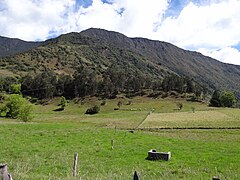
 Landscape around San Mateo


References
Wikimedia Commons has media related to San Mateo, Boyacá.
- ^ a b (in Spanish) Biografía Antonio Caballero y Góngora
- ^ a b c d e (in Spanish) Official website San Mateo
Notes
- v
- t
- e

- Boavita
- Covarachía
- La Uvita
- San Mateo
- Sativanorte
- Sativasur
- Soatá
- Susacón
- Tipacoque
See also: List of municipalities in Boyacá


