Tuta, Boyacá
Municipality and town in Boyacá Department, Colombia

Flag

Location of the municipality and town of Tuta in the Boyacá Department of Colombia
 Colombia
(2020-2023)
(2015)
Tuta is a town and municipality in the Colombian Department of Boyacá, part of the subregion of the Central Boyacá Province. Tuta is situated on the Altiplano Cundiboyacense at a distance of 26 kilometres (16 mi) from the department capital Tunja. It borders Paipa, Pesca and Firavitoba in the east, Cómbita in the west, Sotaquirá and Paipa in the north and Chivatá, Toca and Oicatá in the south.[1]
History
The area of Tuta before the Spanish conquest was inhabited by the Tuta tribe who belonged to the Muisca who were organized in their loose Muisca Confederation. Ruler of the northern territories was the zaque of Hunza, modern day Tunja, who also reigned over Tuta. The Muisca spoke Chibcha and in that now extinct language Tuta means "Borrowed farmlands" or "Property of the Sun".[1][2]
Modern Tuta was properly founded on June 4, 1776, by Miguel Sánchez and Juan Rodríguez Parra.[1]
Economy
The economy of Tuta is centered on agriculture, livestock farming and mining. Agricultural products are potatoes, barley, beans, maize, peas, onions and fruits. Mining consists of gypsum, coal, oil, kaolin, iron ore and sulphur. On the Alto de Ginua hill emeralds were discovered.[1]
Born in Tuta
- Miguel Samacá, former professional cyclist
- Miguel Ángel Sanabria, former professional cyclist
- Raúl Sánchez Niño, artist and folkloric music author.
Gallery
-
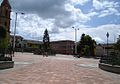 Central square
 -
 Central square
 -
 Central square


-
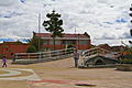
 Church of Tuta
 -
 Church front
 -
 Church tower


References
- ^ a b c d (in Spanish) Official website Tuta
- ^ (in Spanish) Etymology Tuta - Excelsio.net
Wikimedia Commons has media related to Tuta, Boyacá.
5°42′N 73°14′W / 5.700°N 73.233°W / 5.700; -73.233
- v
- t
- e

See also: List of municipalities in Boyacá


