Subprefecture of Itaquera
Subprefecture in Southeast, Brazil
Subprefecture of Itaquera | |
|---|---|
Subprefecture | |
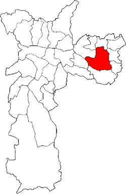 Location of the Subprefecture of Itaquera in São Paulo | |
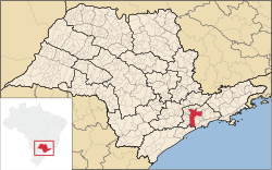 Location of municipality of São Paulo within the State of São Paulo | |
| Country |  Brazil Brazil |
| Region | Southeast |
| State |  São Paulo São Paulo |
| Municipality |  São Paulo São Paulo |
| Administrative Zone | East 1 |
| Districts | Itaquera, Parque do Carmo, José Bonifácio, Cidade Líder |
| Government | |
| • Type | Subprefecture |
| • Subprefect | Paulo César Máximo |
| Area | |
| • Total | 55.32 km2 (21.36 sq mi) |
| Population (2008) | |
| • Total | 525,337 |
| Website | Subprefeitura Itaquera (Portuguese) |
The Subprefecture of Itaquera is one of 32 subprefectures of the city of São Paulo, Brazil. It comprises four districts: Itaquera, Parque do Carmo, José Bonifácio, and Cidade Líder.[1] The name in Tupi means "hard stone" or "insensitive stone".[2]
This subprefecture hosts the Arena Corinthians stadium, in which took place the inauguration of the FIFA World Cup in 2014.
References
- v
- t
- e

- Aricanduva
- Butantã
- Campo Limpo
- Capela do Socorro
- Casa Verde
- Cidade Ademar
- Cidade Tiradentes
- Ermelino Matarazzo
- Freguesia-Brasilândia
- Guaianases
- Ipiranga
- Itaim Paulista
- Itaquera
- Jabaquara
- Jaçanã-Tremembé
- Lapa
- M'Boi Mirim
- Mooca
- Parelheiros
- Penha
- Perus
- Pinheiros
- Pirituba-Jaraguá
- Santana-Tucuruvi
- Santo Amaro
- São Mateus
- São Miguel Paulista
- Sé
- Sapopemba
- Vila Maria-Vila Guilherme
- Vila Mariana
- Vila Prudente
- Água Rasa
- Alto de Pinheiros
- Anhanguera
- Aricanduva
- Artur Alvim
- Barra Funda
- Bela Vista
- Belém
- Bom Retiro
- Brasilândia
- Brás
- Butantã
- Cachoeirinha
- Cambuci
- Campo Belo
- Campo Grande
- Campo Limpo
- Cangaíba
- Capão Redondo
- Carrão
- Casa Verde
- Cidade Ademar
- Cidade Dutra
- Cidade Líder
- Cidade Tiradentes
- Consolação
- Cursino
- Ermelino Matarazzo
- Freguesia do Ó
- Grajaú
- Guaianases
- Iguatemi
- Ipiranga
- Itaim Bibi
- Itaim Paulista
- Itaquera
- Jabaquara
- Jaçanã
- Jaguara
- Jaguaré
- Jaraguá
- Jardim Helena
- Jardim Paulista
- Jardim São Luís
- Jardim Ângela
- José Bonifácio
- Lajeado
- Lapa
- Liberdade
- Limão
- Mandaqui
- Marsilac
- Moema
- Mooca
- Morumbi
- Parelheiros
- Pari
- Parque do Carmo
- Pedreira
- Penha
- Perdizes
- Perus
- Pinheiros
- Pirituba
- Ponte Rasa
- Raposo Tavares
- República
- Rio Pequeno
- Sacomã
- Santa Cecília
- Santana
- Santo Amaro
- São Domingos
- São Lucas
- São Mateus
- São Miguel Paulista
- São Rafael
- Saúde
- Sapopemba
- Sé
- Socorro
- Tatuapé
- Tremembé
- Tucuruvi
- Vila Andrade
- Vila Curuçá
- Vila Formosa
- Vila Guilherme
- Vila Jacuí
- Vila Leopoldina
- Vila Maria
- Vila Mariana
- Vila Matilde
- Vila Medeiros
- Vila Prudente
- Vila Sônia
23°32′00″S 46°27′01″W / 23.53333°S 46.45028°W / -23.53333; -46.45028
 | This geographical article relating to the state of São Paulo is a stub. You can help Wikipedia by expanding it. |
- v
- t
- e


