Coiba Plate
Tectonic plate off the coast south of Panama and northwestern Colombia
06°41′N 80°04′W / 6.683°N 80.067°W / 6.683; -80.067Panama Plate (north)
North Andes Plate (east)
Malpelo Plate (south)
Cocos Plate (west)
Basins:
Chocó Offshore Basin
Colombian Deep Pacific Basin
The Coiba Plate is a small tectonic plate (microplate) located off the coasts south of Panama and northwestern Colombia. It is named after Coiba, the largest island of Central America, just north of the plate offshore southern Panama. It is bounded on the west by the Cocos Plate, on the south by the Malpelo Plate, on the east by the North Andes Plate, and on the north by the Panama Plate. This microplate was previously assumed to be part of the Nazca Plate, forming the northeastern tongue of the Nazca Plate together with the Malpelo Plate. Bordering the Coiba Plate on the east are the north-south striking Bahía Solano Fault and east of that, the Serranía de Baudó, an isolated mountain chain in northwestern Chocó, Colombia.
Description
The Coiba Plate was identified as early as 1981 by Pennington, and later in 1988 by Adamek et al.[1] It is named after Coiba, to the south of mainland Panama, bordering the plate. It was presented together with the newly defined Malpelo Plate by Tuo Zhang and lead-researcher Richard G. Gordon et al. of Rice University in a paper published in August 2017.[1] The Coiba Transform Fault (CTF) separates the Coiba Plate from the Malpelo Plate. The slab tear between the microplates could have happened during the fragmentation of the Farallon Plate, in the Oligocene, around 30 to 25 Ma.[2] The Coiba Ridge, a submerged part of the plate probably formed at the Galápagos hotspot, in contrast with the Malpelo Ridge, a product of volcanic activity.[3]
The researchers led by Gordon used a Columbia University database of multibeam sonar soundings west of Ecuador and Colombia to identify a diffuse plate boundary that runs from the Panama Transform Fault (PTF) eastward.[1]
Gallery
-
 Former plate boundaries in the Pacific, offshore western South America
 -
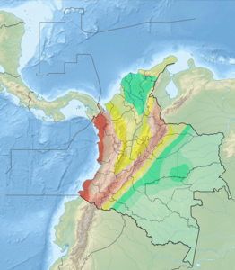 Seismic activity map of Colombia
 -
 Coiba, namesake of the plate


References
 Colombia portal
 Panama portal
 Geology portal


Bibliography
- Chiarabba, Claudio; Pasquale De Gori; Claudio Faccenna; Fabio Speranza; Danilo Seccia; Viviana Dionicio, and German A. Prieto. 2016. Subduction system and flat slab beneath the Eastern Cordillera of Colombia. Geochemistry, Geophysics, Geosystems 17. 16–27. Accessed 2018-06-06.
- Meschede, Martin, and Udo Barckhausen. 2000. Plate tectonic evolution of the Cocos-Nazca spreading center. Proceedings of the Ocean Drilling Program, Scientific Results 170. 1–10. Accessed 2018-06-06.
- Zhang, Tuo; Richard G. Gordon; Jay K. Mishra, and Chengzu Wang. 2017. The Malpelo Plate Hypothesis and implications for nonclosure of the Cocos-Nazca-Pacific plate motion circuit, 1. AGU Fall Meeting, New Orleans. Accessed 2018-06-06.
Further reading
- Patarroyo Camargo, Germán David, and José Ignacio Martínez Rodríguez. 2013. Foraminíferos bentónicos recientes en las aguas profundas de la Cuenca de Panamá: ecología y su posible relación con las corrientes de fondo. Boletín de Investigaciones Marinas y Costeras 42. 31–55. Accessed 2017-09-01.
- Sallarès, Valentí; Philippe Charvis; Ernst R. Flueh, and Joerg Bialas. 2003. Seismic structure of Cocos and Malpelo Volcanic Ridges and implications for hot spot-ridge interaction. Journal of Geophysical Research 108. 1–21. Accessed 2017-09-01.
External links
- Map of the Coiba Plate
- v
- t
- e

- Adriatic
- Aegean Sea
- Anatolian
- Balmoral Reef
- Banda Sea
- Bird's Head
- Capricorn
- Coiba
- Conway Reef
- Easter
- Explorer
- Futuna
- Galápagos
- Gonâve
- Gorda
- Greenland
- Halmahera
- Iberian
- Iranian
- Juan de Fuca
- Juan Fernández
- Kerguelen
- Kermadec
- Lwandle
- Madagascar
- Malpelo
- Manus
- Maoke
- Mariana
- Molucca Sea
- Niuafo’ou
- North Andes
- North Bismarck
- North Galápagos
- Okinawa
- Panama
- Pelso
- Philippine Mobile Belt
- Rivera
- Rovuma
- Sangihe
- Seychelles
- Shetland
- Solomon Sea
- South Bismarck
- South Sandwich
- Timor
- Tisza
- Tonga
- Trobriand
- Victoria
- Woodlark
 Geology portal
 List
List Category
 Commons


| |||||||||||
|---|---|---|---|---|---|---|---|---|---|---|---|
| Tectonic plates |    | ||||||||||
| Terranes |
| ||||||||||
| Terrane-bounding fault systems |
| ||||||||||
| Intraterrane faults |
| ||||||||||
| Major earthquakes | |||||||||||
| Orogenies |
| ||||||||||
| Other topics | |||||||||||
| Sources | Paris, Gabriel; Machette, Michael N.; Dart, Richard L.; Haller, Kathleen M. (2000). Map and Database of Quaternary Faults and Folds in Colombia and its Offshore Regions (PDF). USGS. pp. 1–66. Retrieved 2017-06-20. Gómez Tapias, Jorge; Montes Ramírez, Nohora E.; Almanza Meléndez, María F.; Alcárcel Gutiérrez, Fernando A.; Madrid Montoya, César A.; Diederix, Hans (2015). Geological Map of Colombia. Servicio Geológico Colombiano. pp. 1–212. Retrieved 2019-10-29. Various authors (2014). Enciclopedia de desastres naturales históricos de Colombia (PDF). Universidad del Quindío. pp. 1–21. Retrieved 2017-06-20. | ||||||||||
 Category • Images Category • Images  | |||||||||||


