Malpelo Plate
A small tectonic plate off the coast west of Ecuador and Colombia
03°14′N 81°14′W / 3.233°N 81.233°W / 3.233; -81.233Coiba Plate (north)
North Andes Plate (east)
Nazca Plate (south)
Cocos Plate (west)
Basins:
Chocó Offshore Basin
Colombian Deep Pacific Basin
The Malpelo Plate is a small tectonic plate (microplate) located off the coasts west of Ecuador and Colombia. It is the 57th plate to be identified. It is named after Malpelo Island, the only emerged part of the plate. It is bounded on the west by the Cocos Plate, on the south by the Nazca Plate, on the east by the North Andes Plate, and on the north by the Coiba Plate, separated by the Coiba Transform Fault (CTF). This microplate was previously assumed to be part of the Nazca Plate. The Malpelo Plate borders three major faults of Pacific Colombia, the north to south striking Bahía Solano Fault in the north and the Naya-Micay and Remolino-El Charco Faults in the south.
Description
The Malpelo Plate was hypothesised in 2013 [1] and identified by a non-closure of the Nazca-Cocos-Pacific plate motion circuit, in a paper published in 2017.[2] The formation of the oceanic crust of the plate has been estimated to be since the Middle Miocene (14.7 Ma).[3]
The researchers used a Columbia University database of multibeam sonar soundings west of Ecuador and Colombia to identify a diffuse plate boundary that runs from the Panama Transform Fault (PTF) eastward to where the boundary intersects a deep oceanic trench just offshore of the South American coast, north of the Galapagos Islands.[2]
Gallery
-
 Former plate boundaries in the Pacific, offshore western South America
 -
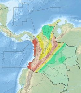 Seismic activity map of Colombia
 -
 Map of Malpelo Island, namesake of the plate
 -
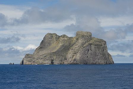 Malpelo Island, the only emerged section of the plate


References
 Colombia portal
 Ecuador portal
 Geology portal


Bibliography
- Herrera Cala, Francys Daniela. 2013. Correlación de eventos sísmicos con la temperatura ambiental, en el área metropolitana de Bucaramanga, 1–167. Universidad Pontificia Bolivariana. Accessed 2017-09-01.
- Meschede, Martin, and Udo Barckhausen. 2000. Plate tectonic evolution of the Cocos-Nazca spreading center. Proceedings of the Ocean Drilling Program, Scientific Results 170. 1–10. Accessed 2017-09-01.
- Zhang, Tuo; Richard G. Gordon; Jay K. Mishra, and Chengzu Wang. 2017. The Malpelo Plate Hypothesis and implications for nonclosure of the Cocos-Nazca-Pacific plate motion circuit. Geophysical Research Letters 44. 1–6. Accessed 2017-09-01.
Further reading
- Lonsdale, Peter, and Daniel Fornari. 1980. Submarine geology of Malpelo Ridge, Panama Basin. Marine Geology 36. 65–83. Accessed 2017-09-01.
- Marcaillou, Boris; Philippe Carvis, and Jean-Yves Collot. 2006. Structure of the Malpelo Ridge (Colombia) from seismic and gravity modelling. Marine Geophysical Research 27. 289–300. Accessed 2017-09-01.
- Patarroyo Camargo, Germán David, and José Ignacio Martínez Rodríguez. 2013. Foraminíferos bentónicos recientes en las aguas profundas de la Cuenca de Panamá: ecología y su posible relación con las corrientes de fondo. Boletín de Investigaciones Marinas y Costeras 42. 31–55. Accessed 2017-09-01.
- Sallarès, Valentí; Philippe Charvis; Ernst R. Flueh, and Joerg Bialas. 2003. Seismic structure of Cocos and Malpelo Volcanic Ridges and implications for hot spot-ridge interaction. Journal of Geophysical Research 108. 1–21. Accessed 2017-09-01.
External links
- Map of the Malpelo Plate
- v
- t
- e

- Adriatic
- Aegean Sea
- Anatolian
- Balmoral Reef
- Banda Sea
- Bird's Head
- Capricorn
- Coiba
- Conway Reef
- Easter
- Explorer
- Futuna
- Galápagos
- Gonâve
- Gorda
- Greenland
- Halmahera
- Iberian
- Iranian
- Juan de Fuca
- Juan Fernández
- Kerguelen
- Kermadec
- Lwandle
- Madagascar
- Malpelo
- Manus
- Maoke
- Mariana
- Molucca Sea
- Niuafo’ou
- North Andes
- North Bismarck
- North Galápagos
- Okinawa
- Panama
- Pelso
- Philippine Mobile Belt
- Rivera
- Rovuma
- Sangihe
- Seychelles
- Shetland
- Solomon Sea
- South Bismarck
- South Sandwich
- Timor
- Tisza
- Tonga
- Trobriand
- Victoria
- Woodlark
 Geology portal
 List
List Category
 Commons


| |||||||||||
|---|---|---|---|---|---|---|---|---|---|---|---|
| Tectonic plates |    | ||||||||||
| Terranes |
| ||||||||||
| Terrane-bounding fault systems |
| ||||||||||
| Intraterrane faults |
| ||||||||||
| Major earthquakes | |||||||||||
| Orogenies |
| ||||||||||
| Other topics | |||||||||||
| Sources | Paris, Gabriel; Machette, Michael N.; Dart, Richard L.; Haller, Kathleen M. (2000). Map and Database of Quaternary Faults and Folds in Colombia and its Offshore Regions (PDF). USGS. pp. 1–66. Retrieved 2017-06-20. Gómez Tapias, Jorge; Montes Ramírez, Nohora E.; Almanza Meléndez, María F.; Alcárcel Gutiérrez, Fernando A.; Madrid Montoya, César A.; Diederix, Hans (2015). Geological Map of Colombia. Servicio Geológico Colombiano. pp. 1–212. Retrieved 2019-10-29. Various authors (2014). Enciclopedia de desastres naturales históricos de Colombia (PDF). Universidad del Quindío. pp. 1–21. Retrieved 2017-06-20. | ||||||||||
 Category • Images Category • Images  | |||||||||||


