Iranian Plate
Small tectonic plate including Iran and Afghanistan, and parts of Iraq and Pakistan
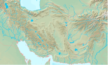
The Iranian Plate is a small tectonic plate thought to underlie the Persian plateau, covering the modern-day countries of Iran and Afghanistan, and parts of Iraq and Pakistan. It is compressed between the Arabian Plate to the southwest, the Eurasian Plate to the north, and the Indian Plate to the southeast. This compression is likely a cause for the very mountainous terrain of the area including the Alborz and Zagros Mountains.
References
- William Bayne Fisher: The Middle East: a Physical, Social, and Regional Geography. Routledge 1978, ISBN 978-0-416-71520-0, p. 15–16
- v
- t
- e
Tectonic plates

- Adriatic
- Aegean Sea
- Anatolian
- Balmoral Reef
- Banda Sea
- Bird's Head
- Capricorn
- Coiba
- Conway Reef
- Easter
- Explorer
- Futuna
- Galápagos
- Gonâve
- Gorda
- Greenland
- Halmahera
- Iberian
- Iranian
- Juan de Fuca
- Juan Fernández
- Kerguelen
- Kermadec
- Lwandle
- Madagascar
- Malpelo
- Manus
- Maoke
- Mariana
- Molucca Sea
- Niuafo’ou
- North Andes
- North Bismarck
- North Galápagos
- Okinawa
- Panama
- Pelso
- Philippine Mobile Belt
- Rivera
- Rovuma
- Sangihe
- Seychelles
- Shetland
- Solomon Sea
- South Bismarck
- South Sandwich
- Timor
- Tisza
- Tonga
- Trobriand
- Victoria
- Woodlark
 Geology portal
 List
List Category
 Commons


This tectonics article is a stub. You can help Wikipedia by expanding it. |
- v
- t
- e


