Denton, County Durham
Human settlement in England
- County Durham
- North East
- Sedgefield
- List of places
- UK
- England
- County Durham
Denton is a village in the borough of Darlington and the ceremonial county of County Durham, England. The population of Denton taken at the 2011 Census was less than 100. Details are maintained in the parish of Gainford. It is situated a short distance to the north-west of Darlington between Walworth to the east and Summerhouse to the west. Houghton-Le-Side lies to the north and Piercebridge to the south.
The village is home to approximately 18 houses, new and old, all surrounding Denton Hall Farm and contained within the vast Raby Estate. Most of the farm buildings are whitewashed. There are many local legends explaining this. The most common of these is that Lord Barnard was lost in the mist and sought refuge in a farm house. Believing it to be one of his own he demanded his keep, only to discover that it was privately owned. To prevent such a mistake occurring again he ordered that all his buildings should be painted white.[1]
Denton Hall Farm is a mixed farm of arable and livestock. Horse racing / training is a large part of village life.
-
 Horses training in 1990
 -
 Denton Village 1990
 -
 Denton Village 1990
 -
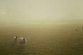 Foggy day in Denton 1990
 -
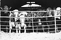 Livestock
 -
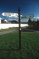 Sign post in Houghton-Le-Side
 -
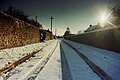 Church Lane, Denton
 -
 Rolled field, Denton


Church history
"Denton, it is believed, has had no less than four chapels at various periods, each one having to be replaced on account of the ruinous state it was allowed to fall into. The first chapel is supposed to have been of Norman Foundation, which gave place to an Early English edifice, this being entirely rebuilt in 1810, and of no particular style. During the rebuilding, an ancient stone coffin was discovered, supposed to be that of a Knight Templar, and later a cover of Frosterley Marble of the same shape, and about the same size, with a sculptured figure of a female carved upon it, was also found. The following inscription in Lombardian French runs round the cover, Hic gist Aubrey de Coynners sa compayn - Here lies the wife of Aubrey de Conyers. The present chapel is a neat stone building in the Early English style, consisting of nave and chancel, with a south porsh at the west end. The chancel fittings and pulpit are of oak and of good design. The chapel is built almost on the site of its predecessor, and will seat 100, having been built at a cost of £1400."[2]

- v
- t
- e
- including Stockton-on-Tees (north of the river)
- Parishes
- Archdeacon Newton
- Barmpton
- Bishopton
- Brafferton
- Coatham Mundeville
- Denton
- East and West Newbiggin
- Great Burdon
- Great Stainton
- Heighington
- High Coniscliffe
- Houghton le Side
- Hurworth
- Killerby
- Little Stainton
- Low Coniscliffe and Merrybent
- Middleton St. George
- Morton Palms
- Neasham
- Piercebridge
- Sadberge
- Summerhouse
- Walworth
- Whessoe
- Unparished areas
- The former Darlington County Borough
- Towns
- Barnard Castle
- Bishop Auckland
- Chilton
- Ferryhill
- Great Aycliffe
- Greater Willington
- Peterlee
- Seaham
- Sedgefield
- Shildon
- Spennymoor
- Stanley
- Tow Law
- Parishes
- Barforth
- Barningham
- Bearpark
- Belmont
- Bishop Middleham
- Bolam
- Boldron
- Bournmoor
- Bowes
- Bradbury and the Isle
- Brancepeth
- Brandon and Byshottles
- Brignall
- Burnhope
- Cassop-cum-Quarrington
- Castle Eden
- City of Durham
- Cleatlam
- Cockfield
- Cornforth
- Cornsay
- Cotherstone
- Coxhoe
- Croxdale and Hett
- Dalton-le-Dale
- Dene Valley
- Easington Colliery
- Easington Village
- Edmondbyers
- Edmondsley
- Eggleston
- Egglestone Abbey
- Eldon
- Esh
- Etherley
- Evenwood and Barony
- Fishburn
- Forest and Frith
- Framwellgate Moor
- Gainford
- Gilmonby
- Great Lumley
- Greencroft
- Hamsterley
- Hamsterley Common
- Haswell
- Hawthorn
- Headlam
- Healeyfield
- Hedleyhope
- Hilton
- Holwick
- Hope
- Horden
- Hunderthwaite
- Hunstanworth
- Hutton Henry and Station Town
- Hutton Magna
- Ingleton
- Kelloe
- Kimblesworth and Plawsworth
- Lanchester
- Langleydale and Shotton
- Langton
- Lartington
- Little Lumley
- Lunedale
- Lynesack and Softley
- Marwood
- Mickleton
- Middleton in Teesdale
- Middridge
- Monk Hesleden
- Mordon
- Morton Tinmouth
- Muggleswick
- Murton
- Nesbitt
- Newbiggin
- North Lodge
- Ouston
- Ovington
- Pelton
- Pittington
- Raby with Keverstone
- Rokeby
- Romaldkirk
- Sacriston
- Satley
- Scargill
- Seaton with Slingley
- Shadforth
- Sheraton with Hulam
- Sherburn Village
- Shincliffe
- Shotton
- South Bedburn
- South Hetton
- Staindrop
- Stanhope
- Startforth
- Streatlam and Stainton
- Thornley
- Toft Hill
- Trimdon
- Trimdon Foundry
- Urpeth
- Waldridge
- Wackerfield
- Weather Hill Wood
- West Auckland
- West Rainton and Leamside
- Westwick
- Wheatley Hill
- Whorlton
- Windlestone
- Wingate
- Winston
- Witton Gilbert
- Witton-le-Wear
- Wolsingham
- Wolsingham Park Moor
- Woodland
- Wycliffe with Thorpe
- Unparished areas
- The former Chester le Street Urban District
- Consett
- Parts of the former Durham Municipal Borough
- Parts of the former Bishop Auckland Urban District
- Crook and Willington Urban District
- Stanley Urban District
- Towns
- Headland
- Parishes
- Brierton
- Claxton
- Dalton Piercy
- Elwick
- Greatham
- Hart
- Newton Bewley
- Wynyard
- Unparished areas
- Part of the former Hartlepool County Borough
- Towns
- Billingham
- Parishes
- Aislaby
- Carlton
- Egglescliffe
- Elton
- Grindon and Thorpe Thewles
- Longnewton
- Newsham
- Preston-on-Tees
- Redmarshall
- Stillington and Whitton
- Wolviston
- Wynyard
- Unparished areas
- Part of the former Teesside County Borough
- For further information about the above parishes, see List of civil parishes in County Durham.
- For the part of Stockton-on-Tees (borough) south of the River Tees, see List of civil parishes in North Yorkshire.
References
More information and photographs of Denton via www.geograph.org.uk [1]


