Thornley, Durham
- See also Thornley in Weardale.
Human settlement in England
- Thornley
- County Durham
- County Durham
- North East
- Sedgefield
- List of places
- UK
- England
- County Durham
Thornley is a village and civil parish in County Durham, England, about 5 miles (9 km) to the east of Durham and 5 miles (7 km) west of Peterlee. The community grew around a coal mine established in 1835, which remained open until 1970.
Governance
The first tier of local government is Thornley Parish Council.[2] Most functions are carried out by Durham County Council, a unitary authority. Thornley is part of Trimdon and Thornley electoral division,[3] which elects three members of the county council.[4]
Thornley is part of the Sedgefield parliamentary constituency of which Tony Blair was the Member of Parliament from 1983 until 2007.
History
Mining
As with most villages in the area, it grew rapidly with the development of coal-mining in the region. The first shaft was sunk in 1835 and the first coals were delivered via a new mineral railway line to Hartlepool shortly thereafter. The village thus played a major role in the development of Hartlepool as a port. Thornley miners played a key role in the formation of the Durham Miners' Association, the first meeting of which was held in the grounds of the village's Half-Way House public house in 1869. The colliery closed in 1970 with the loss of over 900 jobs and there is now little evidence to be seen of its once extensive plant and machinery.
Rebuilding
Easington Rural District Council's policy in the 1960s, 1970s and 1980s was to actively discourage development and employment in the ex-colliery villages of East Durham in favour of the new town of Peterlee. One of the oldest surviving buildings in the village, the Half-Way House was extensively refurbished and extended in the late 1970s and renamed The Crossways Hotel. The building was demolished in early 2008 and planning permission has been given for the building of housing on the site. Permission has also been given for the demolition of another old building, Gore Hall Farm, for the same purpose.
Only recently has new house building been sanctioned by the council in the so-called 'bottom end' of the village. In the meantime, two estates of 20th century council housing have recently been demolished due to the decline in the village's population since the closure of the colliery, Thornlaw North and Coopers Close. The latter was built as recently as 1968 at the expense of a children's recreation ground, several mature trees and many local garden allotments which were also not replaced. The demolition of the Thornlaw North estate has allowed the council to sell the land to a large housebuilding company, Persimmon plc, to build 'executive' housing. A small amount of affordable housing will be built. This project is now (December 2007) well advanced. The council believes that one consequence of the reduction in population is that existing services will be threatened.[5] Plans for the Cooper's Close site have yet to be revealed.
St Bartholomew's Church in the heart of the village, which dates from 1843, was demolished in September 2007. Houses are to be built on the site and many gravestones in the churchyard have already been moved. However, its stained glass windows have been preserved and are currently held in storage for possible future display. The village once had two cinemas, The Hippodrome, built in 1912 and The Ritz, built in 1938: both have been demolished.
Lt John Scott Youll, a former electrician at Thornley Colliery, was awarded the Victoria Cross during his service with the Northumberland Fusiliers in Italy in World War One. The village's war memorial had a special monument added to it in his honour in 2005.
Sport
A greyhound racing and whippet racing track known as the Thornley Greyhound Stadium and earlier the Halfway House running grounds (because of the Halfway House Inn situated next door) existed on the junction of Dunelem Road and the A181.[6] The racing was independent (not affiliated to the sports governing body the National Greyhound Racing Club) and was known as a flapping track, which was the nickname given to independent tracks.[7] The stadium was active in 1936 and was still in place in 1967 but had been demolished by 1976.[8]
Gallery
-
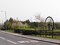 This memorial pit wheel was put in place in 1990. The tree-lined area to the rear covers the site of the actual colliery. The road is the former High Street. Photograph taken in May 2006
 -
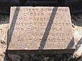 The inscribed stone at the base of the Pit Wheel, photographed in May 2006
 -
 The former High Street, Thornley, photographed in 2006. The War Memorial and Colliery Inn are visible in the distance. The colliery was off the picture to the right. Photograph taken in May 2006
 -
 Hartlepool St Thornley, in 2005. This was once the main shopping street of the village
 -
 Looking up towards St Bartholomew's Church and the remains of the Coopers Close Estate, Thornley, 2005. The housing at the right of the picture was demolished in 2007
 -
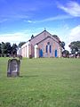 St Bartholomew's Church, Thornley. This photograph was taken in 2005 after the church's closure but prior to the removal of its stained glass windows. The church was demolished in September 2007
 -
 The Thornley War Memorial in 2005, with the John Scott Youll VC Memorial in the foreground and St Bartholomew's Church to the rear
 -
 The Thornley War Memorial in 2005, prior to the addition of the John Scott Youll VC monument. The colliery was directly opposite to the Memorial. Hartlepool Street ran down to the right and High Street up to the left.


References
- ^ "Parish population 2011". Retrieved 21 July 2015.
- ^ "Thornley Parish Council". Retrieved 16 March 2024.
- ^ "Election Maps: Great Britain". Ordnance Survey. Retrieved 16 March 2024.
- ^ "Your Councillors". Durham County Council. Retrieved 16 March 2024.
- ^ Regeneration In Thornley and Wheatley Hill Archived 2008-01-23 at the Wayback Machine
- ^ "OS Plan 1958-1960". old-maps.co.uk.
- ^ Barnes, Julia (1988). Daily Mirror Greyhound Fact File, page 419. Ringpress Books. ISBN 0-948955-15-5.
- ^ "Thornley Greyhound Stadium". Greyhound Racing Times.
External links
Wikimedia Commons has media related to Thornley (near Durham).
- Thornley Parish Council
- Thornley history at wheatleyhill.com
- Thornley Colliery at oldthornley.com
- Thornley Colliery at Durham Mining Museum
- Thornley – a short history – Durham Miner project, Durham County Council, archived in 2007
- Northern Echo article on Thornley history, 5 May 2013
- v
- t
- e
- including Stockton-on-Tees (north of the river)
- Parishes
- Archdeacon Newton
- Barmpton
- Bishopton
- Brafferton
- Coatham Mundeville
- Denton
- East and West Newbiggin
- Great Burdon
- Great Stainton
- Heighington
- High Coniscliffe
- Houghton le Side
- Hurworth
- Killerby
- Little Stainton
- Low Coniscliffe and Merrybent
- Middleton St. George
- Morton Palms
- Neasham
- Piercebridge
- Sadberge
- Summerhouse
- Walworth
- Whessoe
- Unparished areas
- The former Darlington County Borough
- Towns
- Barnard Castle
- Bishop Auckland
- Chilton
- Ferryhill
- Great Aycliffe
- Greater Willington
- Peterlee
- Seaham
- Sedgefield
- Shildon
- Spennymoor
- Stanley
- Tow Law
- Parishes
- Barforth
- Barningham
- Bearpark
- Belmont
- Bishop Middleham
- Bolam
- Boldron
- Bournmoor
- Bowes
- Bradbury and the Isle
- Brancepeth
- Brandon and Byshottles
- Brignall
- Burnhope
- Cassop-cum-Quarrington
- Castle Eden
- City of Durham
- Cleatlam
- Cockfield
- Cornforth
- Cornsay
- Cotherstone
- Coxhoe
- Croxdale and Hett
- Dalton-le-Dale
- Dene Valley
- Easington Colliery
- Easington Village
- Edmondbyers
- Edmondsley
- Eggleston
- Egglestone Abbey
- Eldon
- Esh
- Etherley
- Evenwood and Barony
- Fishburn
- Forest and Frith
- Framwellgate Moor
- Gainford
- Gilmonby
- Great Lumley
- Greencroft
- Hamsterley
- Hamsterley Common
- Haswell
- Hawthorn
- Headlam
- Healeyfield
- Hedleyhope
- Hilton
- Holwick
- Hope
- Horden
- Hunderthwaite
- Hunstanworth
- Hutton Henry and Station Town
- Hutton Magna
- Ingleton
- Kelloe
- Kimblesworth and Plawsworth
- Lanchester
- Langleydale and Shotton
- Langton
- Lartington
- Little Lumley
- Lunedale
- Lynesack and Softley
- Marwood
- Mickleton
- Middleton in Teesdale
- Middridge
- Monk Hesleden
- Mordon
- Morton Tinmouth
- Muggleswick
- Murton
- Nesbitt
- Newbiggin
- North Lodge
- Ouston
- Ovington
- Pelton
- Pittington
- Raby with Keverstone
- Rokeby
- Romaldkirk
- Sacriston
- Satley
- Scargill
- Seaton with Slingley
- Shadforth
- Sheraton with Hulam
- Sherburn Village
- Shincliffe
- Shotton
- South Bedburn
- South Hetton
- Staindrop
- Stanhope
- Startforth
- Streatlam and Stainton
- Thornley
- Toft Hill
- Trimdon
- Trimdon Foundry
- Urpeth
- Waldridge
- Wackerfield
- Weather Hill Wood
- West Auckland
- West Rainton and Leamside
- Westwick
- Wheatley Hill
- Whorlton
- Windlestone
- Wingate
- Winston
- Witton Gilbert
- Witton-le-Wear
- Wolsingham
- Wolsingham Park Moor
- Woodland
- Wycliffe with Thorpe
- Unparished areas
- The former Chester le Street Urban District
- Consett
- Parts of the former Durham Municipal Borough
- Parts of the former Bishop Auckland Urban District
- Crook and Willington Urban District
- Stanley Urban District
- Towns
- Headland
- Parishes
- Brierton
- Claxton
- Dalton Piercy
- Elwick
- Greatham
- Hart
- Newton Bewley
- Wynyard
- Unparished areas
- Part of the former Hartlepool County Borough
- Towns
- Billingham
- Parishes
- Aislaby
- Carlton
- Egglescliffe
- Elton
- Grindon and Thorpe Thewles
- Longnewton
- Newsham
- Preston-on-Tees
- Redmarshall
- Stillington and Whitton
- Wolviston
- Wynyard
- Unparished areas
- Part of the former Teesside County Borough
- For further information about the above parishes, see List of civil parishes in County Durham.
- For the part of Stockton-on-Tees (borough) south of the River Tees, see List of civil parishes in North Yorkshire.
Authority control databases | |
|---|---|
| International |
|
| National |
|


