Grade II* listed buildings in Christchurch
Map all coordinates using OpenStreetMap
Download coordinates as:
- KML
- GPX (all coordinates)
- GPX (primary coordinates)
- GPX (secondary coordinates)

There are over 20,000 Grade II* listed buildings in England. This page is a list of these buildings in the district of Christchurch in Dorset.
Listed buildings
| Name | Location | Type | Completed [note 1] | Date designated | Grid ref.[note 2] Geo-coordinates | Entry number [note 3] | Image |
|---|---|---|---|---|---|---|---|
| Burton Hall | Burton | House | c.1750 | 30 September 1964 | SZ1654595192 50°45′22″N 1°46′01″W / 50.756092°N 1.766814°W / 50.756092; -1.766814 (Burton Hall) | 1154370 |  More images |
| Hurn Court | Hurn | House | End of 16th century | 30 September 1964 | SZ1214895935 50°45′46″N 1°49′45″W / 50.762881°N 1.829124°W / 50.762881; -1.829124 (Hurn Court) | 1324679 |  Upload Photo |
| Church Hatch | Christchurch | House | 18th century | 14 October 1953 | SZ1597592616 50°43′59″N 1°46′30″W / 50.732943°N 1.775006°W / 50.732943; -1.775006 (Church Hatch) | 1324652 |  More images |
| Gateway to Christchurch churchyard | Christchurch Priory | Gate | 19th century | 12 February 1976 | SZ1597492594 50°43′58″N 1°46′30″W / 50.732745°N 1.775021°W / 50.732745; -1.775021 (Gateway to Christchurch churchyard) | 1304357 |  |
| Greystones | Highcliffe | House | 1911–12 | 25 July 1974 | SZ2165493390 50°44′23″N 1°41′40″W / 50.73972°N 1.694492°W / 50.73972; -1.694492 (Greystones) | 1324690 |  |
| Place Mill | Christchurch Priory | Watermill | Medieval | 14 October 1953 | SZ1600192395 50°43′51″N 1°46′29″W / 50.730955°N 1.774647°W / 50.730955; -1.774647 (Place Mill) | 1110074 | 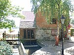 More images |
| Priory Cottage | Christchurch Priory | Porters' lodge | Restored early 16th century | 14 October 1975 | SZ1596192502 50°43′55″N 1°46′31″W / 50.731918°N 1.775209°W / 50.731918; -1.775209 (Priory Cottage) | 1303953 |  More images |
| Railings, gate and wall at No 13 (Church Hatch) | Christchurch | Railings | 18th century | 12 February 1976 | SZ1597292606 50°43′58″N 1°46′30″W / 50.732853°N 1.775049°W / 50.732853; -1.775049 (Railings, gate and wall at No 13 (Church Hatch)) | 1110139 | |
| Red House Museum | Christchurch | Workhouse | 1764 | 14 October 1953 | SZ1589092560 50°43′57″N 1°46′34″W / 50.732441°N 1.776212°W / 50.732441; -1.776212 (Red House Museum) | 1110072 |  More images |
| The Moorings | Mudeford | House | 18th century | 14 October 1953 | SZ1828692064 50°43′40″N 1°44′32″W / 50.727911°N 1.742287°W / 50.727911; -1.742287 (The Moorings) | 1153839 | Upload Photo |
| Tyneham House | Christchurch | House | 18th century | 14 October 1953 | SZ1614292801 50°44′05″N 1°46′21″W / 50.734602°N 1.772631°W / 50.734602; -1.772631 (Tyneham House) | 1108183 | 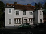 More images |
| 3 Bridge Street | Christchurch | Shop | Early 19th century | 14 October 1953 | SZ1611992767 50°44′03″N 1°46′23″W / 50.734297°N 1.772959°W / 50.734297; -1.772959 (3 Bridge Street) | 1325061 | 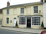 More images |
See also
- Listed buildings in Christchurch, Dorset
- Grade I listed buildings in Dorset
- Grade II* listed buildings in Dorset
- Grade II* listed buildings in Bournemouth
- Grade II* listed buildings in East Dorset
- Grade II* listed buildings in North Dorset
- Grade II* listed buildings in Poole (borough)
- Grade II* listed buildings in Purbeck (district)
- Grade II* listed buildings in West Dorset
- Grade II* listed buildings in Weymouth and Portland
Notes
- ^ The date given is the date used by Historic England as significant for the initial building or that of an important part in the structure's description.
- ^ Sometimes known as OSGB36, the grid reference is based on the British national grid reference system used by the Ordnance Survey.
- ^ The "List Entry Number" is a unique number assigned to each listed building and scheduled monument by Historic England.
External links
- v
- t
- e
- Bedfordshire
- Berkshire
- Bristol
- Buckinghamshire
- Cambridgeshire
- Cheshire
- Cornwall
- Cumbria
- Derbyshire
- Devon
- Dorset
- Durham
- East Sussex
- East Riding of Yorkshire
- Essex
- Gloucestershire
- Greater London
- Greater Manchester
- Hampshire
- Herefordshire
- Hertfordshire
- Isle of Wight
- Kent
- Lancashire
- Leicestershire
- Lincolnshire
- Merseyside
- Norfolk
- North Yorkshire
- Northamptonshire
- Northumberland
- Nottinghamshire
- Oxfordshire
- Rutland
- Shropshire
- Somerset
- South Yorkshire
- Staffordshire
- Suffolk
- Surrey
- Tyne and Wear
- Warwickshire
- West Midlands
- West Sussex
- West Yorkshire
- Wiltshire
- Worcestershire
- Allerdale
- Amber Valley
- Ashford
- Babergh
- Barrow-in-Furness
- Basildon
- Basingstoke and Deane
- Bath and North East Somerset
- Bolsover
- Boston
- Bournemouth
- Bradford
- Braintree
- Breckland
- Brentwood
- Brighton and Hove
- Bristol
- Broadland
- Calderdale
- Cambridge
- Camden
- Canterbury
- Carlisle
- Castle Point
- Chelmsford
- Cheltenham
- Cherwell
- Cheshire East
- Cheshire West and Chester
- Chesterfield
- Chiltern
- Christchurch
- Colchester
- Copeland
- Corby
- Cotswold
- Dartford
- Daventry
- Dover
- East Cambridgeshire
- Exeter
- Mendip
- North Somerset
- North Yorkshire (district)
- Poole
- Sedgemoor
- South Somerset
- Stoke-on-Trent
- Taunton Deane
- West Somerset
- York


