Grade II* listed buildings in Broadland
Map all coordinates using OpenStreetMap
Download coordinates as:
- KML
- GPX (all coordinates)
- GPX (primary coordinates)
- GPX (secondary coordinates)
There are over 20,000 Grade II* listed buildings in England. This page is a list of these buildings in the district of Broadland in Norfolk.
List of buildings
| Name | Location | Type | Completed [note 1] | Date designated | Grid ref.[note 2] Geo-coordinates | Entry number [note 3] | Image |
|---|---|---|---|---|---|---|---|
| Church of St John the Baptist | Alderford | Church | 14th century | 10 May 1961 | TG1237618783 52°43′30″N 1°08′37″E / 52.724978°N 1.143521°E / 52.724978; 1.143521 (Church of St John the Baptist) | 1076888 |  More images |
| Church of St Andrew | Attlebridge | Parish church | c.1300 | 10 May 1961 | TG1294416861 52°42′27″N 1°09′02″E / 52.707503°N 1.150674°E / 52.707503; 1.150674 (Church of St Andrew) | 1372661 |  More images |
| Knoll House | Aylsham | House | Early 18th century | 19 January 1952 | TG1915227026 52°47′47″N 1°14′57″E / 52.796259°N 1.249197°E / 52.796259; 1.249197 (Knoll House) | 1051567 |  Upload Photo |
| Old Bank House | Aylsham | House | Early 18th century | 10 May 1965 | TG1936226831 52°47′40″N 1°15′08″E / 52.794424°N 1.252175°E / 52.794424; 1.252175 (Old Bank House) | 1051551 | Upload Photo |
| The Manor House | Aylsham | House | 17th century | 19 January 1952 | TG1942026751 52°47′37″N 1°15′11″E / 52.793682°N 1.252981°E / 52.793682; 1.252981 (The Manor House) | 1372668 | Upload Photo |
| Yew Tree House Including Boundary Wall | Aylsham | House | 18th century | 1 June 1984 | TG1917627017 52°47′46″N 1°14′58″E / 52.796169°N 1.249546°E / 52.796169; 1.249546 (Yew Tree House Including Boundary Wall) | 1170402 | Upload Photo |
| Church of St Andrew | Blickling | Parish church | Medieval | 10 May 1961 | TG1787328455 52°48′35″N 1°13′52″E / 52.809602°N 1.23121°E / 52.809602; 1.23121 (Church of St Andrew) | 1171857 |  More images |
| The Doric Temple | Blickling Park, Blickling | Garden temple | Early/mid-18th century | 19 January 1952 | TG1823628530 52°48′36″N 1°14′12″E / 52.810129°N 1.236637°E / 52.810129; 1.236637 (The Doric Temple) | 1051432 |  More images |
| The Mausoleum | Blickling Park, Blickling | Mausoleum | 1793 | 19 January 1952 | TG1662529463 52°49′09″N 1°12′48″E / 52.819152°N 1.213393°E / 52.819152; 1.213393 (The Mausoleum) | 1051437 |  More images |
| Church of St Michael and All Angels | Booton | Church | 14th century | 10 May 1961 | TG1229822386 52°45′26″N 1°08′41″E / 52.757349°N 1.144697°E / 52.757349; 1.144697 (Church of St Michael and All Angels) | 1342776 |  More images |
| Church of St Michael | Oxnead, Brampton | Parish church | 13th century | 10 May 1961 | TG2297424051 52°46′05″N 1°18′14″E / 52.767996°N 1.303761°E / 52.767996; 1.303761 (Church of St Michael) | 1050959 |  More images |
| Church of St Peter | Brampton | Parish church | 12th century | 10 May 1961 | TG2197324610 52°46′24″N 1°17′22″E / 52.773424°N 1.289328°E / 52.773424; 1.289328 (Church of St Peter) | 1372950 | 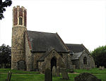 More images |
| Oxnead Hall | Oxnead, Brampton | Country house | Late 16th century | 10 May 1961 | TG2307224012 52°46′03″N 1°18′19″E / 52.767605°N 1.305185°E / 52.767605; 1.305185 (Oxnead Hall) | 1372951 |  More images |
| Church of St Nicholas | Brandiston | Church | 14th century | 10 May 1961 | TG1413221423 52°44′53″N 1°10′16″E / 52.747982°N 1.171202°E / 52.747982; 1.171202 (Church of St Nicholas) | 1076897 | 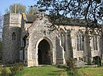 More images |
| Church of St Lawrence | Brundall | Parish church | 13th century | 25 September 1962 | TG3216108452 52°37′27″N 1°25′43″E / 52.624151°N 1.428684°E / 52.624151; 1.428684 (Church of St Lawrence) | 1051519 | 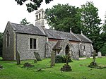 More images |
| Burgh Mill | Burgh and Tuttington | Watermill | Late 18th century | 18 November 1983 | TG2221525093 52°46′40″N 1°17′36″E / 52.77766°N 1.293237°E / 52.77766; 1.293237 (Burgh Mill) | 1250712 |  More images |
| Church of St Peter and Paul | Tuttington, Burgh and Tuttington | Parish church | 12th century | 10 May 1961 | TG2265527187 52°47′47″N 1°18′04″E / 52.796271°N 1.301172°E / 52.796271; 1.301172 (Church of St Peter and Paul) | 1050931 |  More images |
| Church of St Andrew | Buxton, Buxton with Lammas | Parish church | 14th century | 10 May 1961 | TG2335122704 52°45′21″N 1°18′30″E / 52.755751°N 1.308422°E / 52.755751; 1.308422 (Church of St Andrew) | 1249960 | 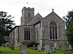 More images |
| Church of St Andrew | Lammas, Buxton with Lammas | Parish church | 15th century | 10 May 1961 | TG2452823217 52°45′36″N 1°19′34″E / 52.759868°N 1.326183°E / 52.759868; 1.326183 (Church of St Andrew) | 1372945 |  More images |
| Little Hautbois Hall | Little Hautbois, Buxton with Lammas | Country house | Late 16th century | 19 January 1952 | TG2488221942 52°44′54″N 1°19′50″E / 52.748278°N 1.330547°E / 52.748278; 1.330547 (Little Hautbois Hall) | 1050941 | 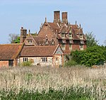 More images |
| Church of St Botolph | Limpenhoe, Cantley, Limpenhoe and Southwood | Parish church | 15th century | 25 September 1962 | TG3953003992 52°34′51″N 1°32′03″E / 52.580935°N 1.534111°E / 52.580935; 1.534111 (Church of St Botolph) | 1051451 |  More images |
| Church of St Margaret | Cantley | Parish church | 1250 | 25 September 1962 | TG3816704140 52°34′58″N 1°30′51″E / 52.582862°N 1.51414°E / 52.582862; 1.51414 (Church of St Margaret) | 1304803 |  More images |
| Remains of Church of St Edmunds | Southwood, Cantley, Limpenhoe and Southwood | Parish church | 14th century | 25 September 1962 | TG3911205316 52°35′35″N 1°31′44″E / 52.592999°N 1.528909°E / 52.592999; 1.528909 (Remains of Church of St Edmunds) | 1372698 |  More images |
| Bank Cottage and Oak House | Cawston | House | c.1700 | 10 May 1961 | TG1351623897 52°46′14″N 1°09′49″E / 52.770432°N 1.1637°E / 52.770432; 1.1637 (Bank Cottage and Oak House) | 1050949 | Upload Photo |
| Church of St Theobald | Great Hautbois, Coltishall | Church | 15th century | 10 May 1961 | TG2617820431 52°44′03″N 1°20′55″E / 52.734178°N 1.348673°E / 52.734178; 1.348673 (Church of St Theobald) | 1295280 |  More images |
| The Limes and attached garden walls | Coltishall | House | 1692 | 19 January 1952 | TG2759919831 52°43′42″N 1°22′09″E / 52.728198°N 1.369265°E / 52.728198; 1.369265 (The Limes and attached garden walls) | 1295241 | Upload Photo |
| The Old House | Coltishall | House | 1727 | 10 May 1961 | TG2694219745 52°43′40″N 1°21′34″E / 52.727702°N 1.359494°E / 52.727702; 1.359494 (The Old House) | 1372990 | Upload Photo |
| Drayton Lodge | Drayton | Summerhouse | 15th century | 19 January 1952 | TG1864313154 52°40′19″N 1°13′57″E / 52.671961°N 1.232429°E / 52.671961; 1.232429 (Drayton Lodge) | 1306023 | 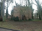 |
| Parish Church of St Margaret | Drayton | Parish church | 15th century | 19 January 1952 | TG1804413741 52°40′39″N 1°13′26″E / 52.677471°N 1.223973°E / 52.677471; 1.223973 (Parish Church of St Margaret) | 1306000 |  More images |
| Parish Church of St Margaret | Felthorpe | Parish church | 14th century | 10 May 1961 | TG1698017318 52°42′36″N 1°12′38″E / 52.710003°N 1.210617°E / 52.710003; 1.210617 (Parish Church of St Margaret) | 1051539 |  More images |
| Old Hall Farm House | Foulsham | Farmhouse | 16th century | 19 January 1952 | TG0345724907 52°47′00″N 1°00′56″E / 52.783378°N 1.015444°E / 52.783378; 1.015444 (Old Hall Farm House) | 1372926 | Upload Photo |
| Table tomb to the north-east of the west door of the Church of the Holy Innocents | Foulsham | Table tomb | c.1505 | 3 May 1983 | TG0325025068 52°47′06″N 1°00′45″E / 52.784902°N 1.012479°E / 52.784902; 1.012479 (Table tomb to the north-east of the west door of the Church of the Holy Innocents) | 1050985 |  |
| Church of All Saints | Freethorpe | Parish church | Tower probably Norman | 25 September 1962 | TG4086705507 52°35′38″N 1°33′18″E / 52.593939°N 1.554905°E / 52.593939; 1.554905 (Church of All Saints) | 1051456 | 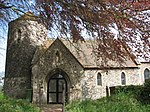 More images |
| Stock house 47 metres south of the Manor House | Freethorpe | Animal shed | 1828 | 20 February 1952 | TG4114704986 52°35′21″N 1°33′31″E / 52.58914°N 1.558652°E / 52.58914; 1.558652 (Stock house 47 metres south of the Manor House) | 1152503 | Upload Photo |
| Church of St Swithin | Frettenham | Parish church | 14th century | 10 May 1961 | TG2448518529 52°43′04″N 1°19′20″E / 52.717813°N 1.322343°E / 52.717813; 1.322343 (Church of St Swithin) | 1372955 |  More images |
| Church of St Gervase and Protase | Little Plumstead, Great and Little Plumstead | Parish church | 13th century and later | 25 September 1962 | TG3074110859 52°38′47″N 1°24′34″E / 52.646356°N 1.409425°E / 52.646356; 1.409425 (Church of St Gervase and Protase) | 1051528 |  More images |
| The Grange, garden walls, attached greenhouse and outbuildings | Little Plumstead, Great and Little Plumstead | House | 16th century | 19 March 1985 | TG3146610938 52°38′48″N 1°25′13″E / 52.646756°N 1.420177°E / 52.646756; 1.420177 (The Grange, garden walls, attached greenhouse and outbuildings) | 1372657 | Upload Photo |
| Great Witchingham Hall | Great Witchingham | Country house | Late 16th–early 17th century | 19 January 1952 | TG1118618603 52°43′26″N 1°07′33″E / 52.723827°N 1.125812°E / 52.723827; 1.125812 (Great Witchingham Hall) | 1076861 | 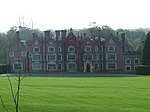 More images |
| Manor House | Great Witchingham | Farmhouse | 17th century | 19 January 1952 | TG1029721416 52°44′58″N 1°06′52″E / 52.749424°N 1.114469°E / 52.749424; 1.114469 (Manor House) | 1306691 | 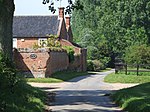 |
| Congregational Chapel | Guestwick | Chapel/timber framed house | 1625 | 2 November 1972 | TG0606527228 52°48′12″N 1°03′20″E / 52.803225°N 1.055517°E / 52.803225; 1.055517 (Congregational Chapel) | 1372914 |  More images |
| Mutton's Mill | Halvergate Marshes, Halvergate | Drainage mill | Mid-19th century | 26 February 1987 | TG4412506349 52°36′00″N 1°36′13″E / 52.600041°N 1.603527°E / 52.600041; 1.603527 (Mutton's Mill) | 1051457 |  More images |
| Remains of Church of St Peter and St Paul | Tunstall, Halvergate | Parish church | 13th century and later | 25 September 1962 | TG4170508021 52°36′58″N 1°34′09″E / 52.616123°N 1.569088°E / 52.616123; 1.569088 (Remains of Church of St Peter and St Paul) | 1372727 |  More images |
| Stracey Arms Windpump | Tunstall, Halvergate | Drainage mill | 1883 | 7 December 1962 | TG4416408969 52°37′25″N 1°36′22″E / 52.62353°N 1.606034°E / 52.62353; 1.606034 (Stracey Arms Windpump) | 1051459 |  More images |
| Parish Church of St Peter | Haveringland | Parish church | 11th century tower | 10 May 1961 | TG1514920902 52°44′34″N 1°11′09″E / 52.742902°N 1.185903°E / 52.742902; 1.185903 (Parish Church of St Peter) | 1372948 |  More images |
| Parish Church of St Mary | Hellesdon | Parish church | 15th century | 10 May 1961 | TG2005310614 52°38′55″N 1°15′06″E / 52.648594°N 1.251553°E / 52.648594; 1.251553 (Parish Church of St Mary) | 1170678 |  More images |
| Cropton Hall | Heydon | Farmhouse | 17th century | 19 January 1952 | TG1079428374 52°48′42″N 1°07′35″E / 52.811686°N 1.126298°E / 52.811686; 1.126298 (Cropton Hall) | 1305357 |  |
| Church of St Andrew | Honingham | Parish church | 14th century | 10 May 1961 | TG1141711245 52°39′28″N 1°07′28″E / 52.65769°N 1.124504°E / 52.65769; 1.124504 (Church of St Andrew) | 1170701 |  More images |
| Parish Church of All Saints | Horsford | Parish church | 1456 | 10 May 1961 | TG1968415379 52°41′29″N 1°14′57″E / 52.691511°N 1.249282°E / 52.691511; 1.249282 (Parish Church of All Saints) | 1170781 |  More images |
| Mayton Old Bridge | Horstead with Stanninghall | Bridge | Early 16th century | 10 May 1961 | TG2499621561 52°44′41″N 1°19′55″E / 52.744812°N 1.331971°E / 52.744812; 1.331971 (Mayton Old Bridge) | 1178140 | 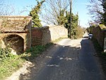 More images |
| Parish Church of All Saints | Horstead with Stanninghall | Parish church | Early 14th century | 10 May 1961 | TG2628519915 52°43′46″N 1°21′00″E / 52.729503°N 1.349899°E / 52.729503; 1.349899 (Parish Church of All Saints) | 1178235 | 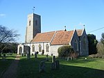 More images |
| Old Hall Farmhouse | South Burlingham, Lingwood and Burlingham | Farmhouse | Late 16th century | 20 February 1952 | TG3726007832 52°36′59″N 1°30′12″E / 52.616386°N 1.503424°E / 52.616386; 1.503424 (Old Hall Farmhouse) | 1152874 |  More images |
| Church of St Faith | Little Witchingham | Church | 14th century | 22 July 1983 | TG1154920233 52°44′18″N 1°07′56″E / 52.738317°N 1.132228°E / 52.738317; 1.132228 (Church of St Faith) | 1342803 |  More images |
| Church of St Margaret | Morton on the Hill | Parish church | 13th century | 10 May 1961 | TG1249415828 52°41′54″N 1°08′36″E / 52.698407°N 1.143357°E / 52.698407; 1.143357 (Church of St Margaret) | 1051548 |  More images |
| Parish Church of St Margaret | Old Catton | Parish church | 12th century | 10 May 1961 | TG2306012324 52°39′46″N 1°17′49″E / 52.662714°N 1.297081°E / 52.662714; 1.297081 (Parish Church of St Margaret) | 1152550 |  More images |
| The Firs | Old Catton | House | c.1750 | 19 January 1952 | TG2335711812 52°39′29″N 1°18′04″E / 52.657997°N 1.301118°E / 52.657997; 1.301118 (The Firs) | 1372964 | Upload Photo |
| Church of St Peter and St Paul | Oulton | Parish church | 15th century | 10 May 1961 | TG1365428460 52°48′41″N 1°10′07″E / 52.811333°N 1.16872°E / 52.811333; 1.16872 (Church of St Peter and St Paul) | 1372723 |  More images |
| Congregational Chapel | Oulton | Nonconformist chapel | 1728 | 14 February 1978 | TG1409129210 52°49′04″N 1°10′32″E / 52.817892°N 1.175684°E / 52.817892; 1.175684 (Congregational Chapel) | 1172066 |  More images |
| Church of All Saints | Postwick, Postwick with Witton | Parish church | Medieval | 20 May 1952 | TG2961307826 52°37′11″N 1°23′26″E / 52.619616°N 1.390676°E / 52.619616; 1.390676 (Church of All Saints) | 1372681 |  More images |
| Church of St Margaret | Witton, Postwick with Witton | Parish church | Medieval | 20 May 1952 | TG3142309713 52°38′09″N 1°25′07″E / 52.635782°N 1.418684°E / 52.635782; 1.418684 (Church of St Margaret) | 1153110 |  More images |
| Polkey's Mill, 75 metres north-east of Seven Mile House | Reedham | Drainage mill | Mid-19th century | 26 February 1987 | TG4442803494 52°34′27″N 1°36′21″E / 52.57429°N 1.605886°E / 52.57429; 1.605886 (Polkey's Mill, 75 metres north-east of Seven Mile House) | 1051425 | 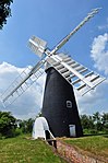 More images |
| Church of St Michael and All Angels | Reepham | Church | 14th century | 10 May 1961 | TG1010822856 52°45′45″N 1°06′45″E / 52.762423°N 1.112596°E / 52.762423; 1.112596 (Church of St Michael and All Angels) | 1306488 |  More images |
| Old Hall | Kerdiston, Reepham | Manor house | Early 17th century | 22 July 1983 | TG0874824144 52°46′28″N 1°05′36″E / 52.774511°N 1.093291°E / 52.774511; 1.093291 (Old Hall) | 1169735 |  More images |
| Manor House | Salle | House | Early 17th century | 19 January 1952 | TG1168325250 52°47′00″N 1°08′15″E / 52.783297°N 1.137447°E / 52.783297; 1.137447 (Manor House) | 1076855 |  |
| Moor Hall | Salle Moor, Salle | House | Late 17th century | 19 January 1952 | TG0992424605 52°46′41″N 1°06′40″E / 52.778194°N 1.110993°E / 52.778194; 1.110993 (Moor Hall) | 1342799 |  More images |
| Salle Park | Salle | Country house | 1761 | 19 January 1952 | TG1161824556 52°46′38″N 1°08′10″E / 52.777093°N 1.136036°E / 52.777093; 1.136036 (Salle Park) | 1170353 |  More images |
| Church of St Lawrence | South Walsham | Parish church | Medieval | 25 September 1962 | TG3658213270 52°39′56″N 1°29′50″E / 52.665476°N 1.497323°E / 52.665476; 1.497323 (Church of St Lawrence) | 1051496 |  More images |
| Church of St Mary | Hassingham, Strumpshaw | Parish church | 12th century | 25 September 1962 | TG3690405514 52°35′45″N 1°29′47″E / 52.595742°N 1.496517°E / 52.595742; 1.496517 (Church of St Mary) | 1303861 |  More images |
| Swannington Hall | Swannington | House | 16th century | 19 January 1952 | TG1382919302 52°43′45″N 1°09′55″E / 52.729064°N 1.165339°E / 52.729064; 1.165339 (Swannington Hall) | 1263205 | Upload Photo |
| Church of St Andrew | Themelthorpe | Parish church | 13th century | 10 May 1961 | TG0575724090 52°46′31″N 1°02′56″E / 52.775173°N 1.048984°E / 52.775173; 1.048984 (Church of St Andrew) | 1170136 |  More images |
| Garden house 40m south of Walpole House | Thorpe St. Andrew | Gazebo | Mid-18th century | 20 February 1952 | TG2566008388 52°37′35″N 1°19′58″E / 52.626316°N 1.332769°E / 52.626316; 1.332769 (Garden house 40m south of Walpole House) | 1372706 | Upload Photo |
| Ruin of Church of St Andrew | Thorpe St. Andrew | Parish church | 15th century | 25 September 1962 | TG2606308411 52°37′35″N 1°20′19″E / 52.626355°N 1.338728°E / 52.626355; 1.338728 (Ruin of Church of St Andrew) | 1051503 |  More images |
| Thorpe Hall | Thorpe St. Andrew | Bishops palace | Earlier | 20 February 1952 | TG2554008396 52°37′35″N 1°19′52″E / 52.626437°N 1.331005°E / 52.626437; 1.331005 (Thorpe Hall) | 1154440 | Upload Photo |
| Walpole House | Thorpe St. Andrew | House | 17th century | 20 February 1952 | TG2565008431 52°37′36″N 1°19′58″E / 52.626706°N 1.332651°E / 52.626706; 1.332651 (Walpole House) | 1051508 | Upload Photo |
| Church of St Mary | Fishley, Upton with Fishley | Parish church | 12th century | 25 September 1962 | TG3988011491 52°38′53″N 1°32′41″E / 52.648067°N 1.544703°E / 52.648067; 1.544703 (Church of St Mary) | 1051427 |  More images |
| Wood Dalling Hall | Wood Dalling | Country house | Late 16th century | 19 January 1952 | TG0742927026 52°48′03″N 1°04′32″E / 52.800889°N 1.075593°E / 52.800889; 1.075593 (Wood Dalling Hall) | 1305293 | Upload Photo |
| Church of St Fabian and St Sebastian | Woodbastwick | Parish church | Medieval | 25 September 1962 | TG3324915226 52°41′04″N 1°26′58″E / 52.684471°N 1.449514°E / 52.684471; 1.449514 (Church of St Fabian and St Sebastian) | 1154614 |  More images |
| Porch attached to east by garden walls to Ranworth Old Hall | Ranworth, Woodbastwick | Manor house | Early 16th century | 20 February 1952 | TG3449515402 52°41′08″N 1°28′05″E / 52.685513°N 1.468037°E / 52.685513; 1.468037 (Porch attached to east by garden walls to Ranworth Old Hall) | 1051473 |  |
| Ruined Church of All Saints | Panxworth, Woodbastwick | Church | 14th century | 25 September 1962 | TG3474413567 52°40′08″N 1°28′13″E / 52.66894°N 1.470407°E / 52.66894; 1.470407 (Ruined Church of All Saints) | 1372709 |  More images |
Formerly listed buildings
| Name | Location | Type | Completed [note 1] | Date designated | Grid ref.[note 2] Geo-coordinates | Entry number [note 3] | Image |
|---|---|---|---|---|---|---|---|
| Ranworth Old Hall | Ranworth, Woodbastwick | House (demolished 1985) | Earlier | 20 February 1952 | TG3446315393 52°41′08″N 1°28′03″E / 52.685446°N 1.467558°E / 52.685446; 1.467558 (Ranworth Old Hall) |  More images |
See also
Notes
- ^ a b The date given is the date used by Historic England as significant for the initial building or that of an important part in the structure's description.
- ^ a b Sometimes known as OSGB36, the grid reference is based on the British national grid reference system used by the Ordnance Survey.
- ^ a b The "List Entry Number" is a unique number assigned to each listed building and scheduled monument by Historic England.
External links
- v
- t
- e
- Bedfordshire
- Berkshire
- Bristol
- Buckinghamshire
- Cambridgeshire
- Cheshire
- Cornwall
- Cumbria
- Derbyshire
- Devon
- Dorset
- Durham
- East Sussex
- East Riding of Yorkshire
- Essex
- Gloucestershire
- Greater London
- Greater Manchester
- Hampshire
- Herefordshire
- Hertfordshire
- Isle of Wight
- Kent
- Lancashire
- Leicestershire
- Lincolnshire
- Merseyside
- Norfolk
- North Yorkshire
- Northamptonshire
- Northumberland
- Nottinghamshire
- Oxfordshire
- Rutland
- Shropshire
- Somerset
- South Yorkshire
- Staffordshire
- Suffolk
- Surrey
- Tyne and Wear
- Warwickshire
- West Midlands
- West Sussex
- West Yorkshire
- Wiltshire
- Worcestershire
- Allerdale
- Amber Valley
- Ashford
- Babergh
- Barrow-in-Furness
- Basildon
- Basingstoke and Deane
- Bath and North East Somerset
- Bolsover
- Boston
- Bournemouth
- Bradford
- Braintree
- Breckland
- Brentwood
- Brighton and Hove
- Bristol
- Broadland
- Calderdale
- Cambridge
- Camden
- Canterbury
- Carlisle
- Castle Point
- Chelmsford
- Cheltenham
- Cherwell
- Cheshire East
- Cheshire West and Chester
- Chesterfield
- Chiltern
- Christchurch
- Colchester
- Copeland
- Corby
- Cotswold
- Craven
- Dartford
- Daventry
- Dover
- East Cambridgeshire
- Exeter
- Mendip
- North Somerset
- Poole
- Sedgemoor
- South Somerset
- Stoke-on-Trent
- Taunton Deane
- West Somerset
- York


