Grade II* listed buildings in Cheltenham
Map all coordinates using OpenStreetMap
Download coordinates as:
- KML
- GPX (all coordinates)
- GPX (primary coordinates)
- GPX (secondary coordinates)
There are over 20,000 Grade II* listed buildings in England. This page is a list of these buildings in the district of Cheltenham in Gloucestershire.
List of buildings
| Name | Location | Type | Completed [note 1] | Date designated | Grid ref.[note 2] Geo-coordinates | Entry number [note 3] | Image |
|---|---|---|---|---|---|---|---|
| Charlton Park (St Edwards School Main Building) | Charlton Kings | Country house | c.1720 | 22 April 1950 | SO9593820805 51°53′09″N 2°03′38″W / 51.885788°N 2.060424°W / 51.885788; -2.060424 (Charlton Park (St Edwards School Main Building)) | 1386593 | 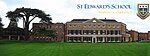 More images |
| Church of St Mary | Charlton Kings | Parish church | Norman; c.1190 | 22 April 1950 | SO9645020441 51°52′57″N 2°03′11″W / 51.882519°N 2.052981°W / 51.882519; -2.052981 (Church of St Mary) | 1386562 |  More images |
| Churchyard cross approximately 15 metres north-west of west door of Church of St Mary | Charlton Kings | Cross | 15th century | 24 April 1950 | SO9642620458 51°52′58″N 2°03′12″W / 51.882672°N 2.05333°W / 51.882672; -2.05333 (Churchyard cross approximately 15 metres north-west of west door of Church of St Mary) | 1386564 |  |
| King's House | Charlton Kings | House | c.1603 | 22 April 1950 | SO9660820724 51°53′06″N 2°03′02″W / 51.885065°N 2.050688°W / 51.885065; -2.050688 (King's House) | 1386658 |  Upload Photo |
| South West Regency (administration) Block to St Edwards Middle School | Charlton Kings | Villa | c.1832 | 8 February 1983 | SO9653621465 51°53′30″N 2°03′06″W / 51.891726°N 2.051742°W / 51.891726; -2.051742 (South West Regency (administration) Block to St Edwards Middle School) | 1386540 | Upload Photo |
| The Court House | Charlton Kings | House | 1614 | 23 March 1982 | SO9602420544 51°53′00″N 2°03′33″W / 51.883442°N 2.059171°W / 51.883442; -2.059171 (The Court House) | 1386653 | Upload Photo |
| Church of St Peter | Leckhampton | Church | 12th-century origins | 4 July 1960 | SO9429619403 51°52′23″N 2°05′03″W / 51.873168°N 2.084257°W / 51.873168; -2.084257 (Church of St Peter) | 1340121 |  More images |
| Leckhampton Court with wall and gate piers | Leckhampton | House | 14th century | 4 July 1960 | SO9449919338 51°52′21″N 2°04′53″W / 51.872586°N 2.081307°W / 51.872586; -2.081307 (Leckhampton Court with wall and gate piers) | 1091754 |  More images |
| Church of St Mary | Prestbury | Anglican church | 13th century | 4 July 1960 | SO9699223992 51°54′52″N 2°02′43″W / 51.914449°N 2.045139°W / 51.914449; -2.045139 (Church of St Mary) | 1153687 |  More images |
| Francis Kemmet(t) Monument in the churchyard of the Church of St Mary circa 3 metres north of north aisle | Prestbury | Chest tomb | 1716 | 25 February 1987 | SO9698724004 51°54′52″N 2°02′43″W / 51.914557°N 2.045212°W / 51.914557; -2.045212 (Francis Kemmet(t) Monument in the churchyard of the Church of St Mary circa 3 metres north of north aisle) | 1153742 |  More images |
| Church of St Lawrence | Swindon Village | Anglican church | 12th century | 4 July 1960 | SO9346324886 51°55′21″N 2°05′47″W / 51.922456°N 2.096462°W / 51.922456; -2.096462 (Church of St Lawrence) | 1091887 |  More images |
| Alma House and walls and piers adjoining | Cheltenham | Villa | 1838 | 12 March 1955 | SO9484622120 51°53′51″N 2°04′35″W / 51.897602°N 2.07631°W / 51.897602; -2.07631 (Alma House and walls and piers adjoining) | 1387813 |  More images |
| Bayshill House and Lingwood House | Cheltenham | Villa | c.1839–42 | 12 March 1955 | SO9446522184 51°53′53″N 2°04′55″W / 51.898174°N 2.081848°W / 51.898174; -2.081848 (Bayshill House and Lingwood House) | 1386735 | Upload Photo |
| Bayshill Lodge (1, 2 and 3), ballroom mews arch to north-west, and Nos 1–19 Rotunda Terrace | Cheltenham | House | 1844/1851 | 12 March 1955 | SO9439721891 51°53′44″N 2°04′58″W / 51.895539°N 2.082831°W / 51.895539; -2.082831 (Bayshill Lodge (1, 2 and 3), ballroom mews arch to north-west, and Nos 1–19 Rotunda Terrace) | 1387125 |  More images |
| Brandon House | Cheltenham | Villa | 1834–39 | 12 March 1955 | SO9438821087 51°53′18″N 2°04′59″W / 51.88831°N 2.082948°W / 51.88831; -2.082948 (Brandon House) | 1387401 |  |
| Cheltenham College (main block to road with Dining Hall and Chapel) | Cheltenham | Public school | 1843 | 12 March 1955 | SO9486121501 51°53′31″N 2°04′34″W / 51.892037°N 2.076082°W / 51.892037; -2.076082 (Cheltenham College (main block to road with Dining Hall and Chapel)) | 1386726 |  More images |
| Christ Church and adjacent Church Hall | Cheltenham | Church | 1837–40 | 12 March 1955 | SO9399622280 51°53′57″N 2°05′19″W / 51.899032°N 2.088665°W / 51.899032; -2.088665 (Christ Church and adjacent Church Hall) | 1103838 |  More images |
| Church of St Gregory | Cheltenham | Church | 1859 | 5 May 1972 | SO9457022558 51°54′06″N 2°04′49″W / 51.901537°N 2.080328°W / 51.901537; -2.080328 (Church of St Gregory) | 1387870 |  More images |
| Church of St Matthew | Cheltenham | Church | 1877–79 | 14 December 1983 | SO9469822503 51°54′04″N 2°04′42″W / 51.901044°N 2.078466°W / 51.901044; -2.078466 (Church of St Matthew) | 1386868 |  More images |
| Church of St Paul | Cheltenham | Church | 1831 | 12 March 1955 | SO9478823169 51°54′25″N 2°04′38″W / 51.907033°N 2.077169°W / 51.907033; -2.077169 (Church of St Paul) | 1387184 | 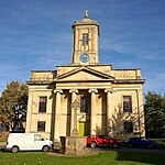 More images |
| Church of St Peter | Cheltenham | Parish church | 1847–48 | 12 March 1955 | SO9385523361 51°54′31″N 2°05′27″W / 51.908749°N 2.090734°W / 51.908749; -2.090734 (Church of St Peter) | 1388006 |  More images |
| Church of St Philip and St James with attached walls and gates | Cheltenham | Church | 1879–82 | 14 December 1983 | SO9444221120 51°53′19″N 2°04′56″W / 51.888607°N 2.082164°W / 51.888607; -2.082164 (Church of St Philip and St James with attached walls and gates) | 1245772 |  More images |
| Church of St Stephen | Tivoli | Church | 1873–74 | 14 December 1983 | SO9388521380 51°53′27″N 2°05′25″W / 51.890939°N 2.090262°W / 51.890939; -2.090262 (Church of St Stephen) | 1387915 | Upload Photo |
| Church of the Holy Trinity | Cheltenham | Church | 1820–23 | 12 March 1955 | SO9517822772 51°54′12″N 2°04′17″W / 51.903467°N 2.071494°W / 51.903467; -2.071494 (Church of the Holy Trinity) | 1387583 |  More images |
| Claremont Lodge | Cheltenham | Apartment | c.1800–10 | 12 March 1955 | SO9475321845 51°53′42″N 2°04′40″W / 51.895129°N 2.077657°W / 51.895129; -2.077657 (Claremont Lodge) | 1387123 | 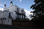 |
| Clarence House and attached railings | Cheltenham | Villa | 1830–34 | 12 March 1955 | SO9456622046 51°53′49″N 2°04′49″W / 51.896934°N 2.080378°W / 51.896934; -2.080378 (Clarence House and attached railings) | 1387687 | Upload Photo |
| Evelyn Terrace, Lansdown Terrace, Evelyn Court, Regan House, attached railings and mews archway | Cheltenham | Apartment | c.1832 | 12 March 1955 | SO9413522011 51°53′48″N 2°05′12″W / 51.896615°N 2.086641°W / 51.896615; -2.086641 (Evelyn Terrace, Lansdown Terrace, Evelyn Court, Regan House, attached railings and mews archway) | 1103835 | 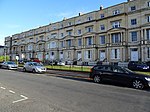 |
| Francis Close College: Old Practising School | Cheltenham | School | 1854–58 | 5 May 1972 | SO9462423128 51°54′24″N 2°04′46″W / 51.906663°N 2.079552°W / 51.906663; -2.079552 (Francis Close College: Old Practising School) | 1387896 |  |
| General Hospital (central block) and attached railings | Cheltenham | Hospital | 1848 | 5 May 1972 | SO9513721512 51°53′32″N 2°04′19″W / 51.892138°N 2.072072°W / 51.892138; -2.072072 (General Hospital (central block) and attached railings) | 1387935 |  More images |
| George Hotel (nos 41–49) and attached railings to Nos 29–39 and 43–49 | Cheltenham | House | c.1837–45 | 12 March 1955 | SO9449722299 51°53′57″N 2°04′53″W / 51.899208°N 2.081384°W / 51.899208; -2.081384 (George Hotel (nos 41–49) and attached railings to Nos 29–39 and 43–49) | 1387846 |  |
| Gloucester Lodge (No 129) Sherborne Lodge (No 131) gate piers and gates | Cheltenham | Villa | 1833–34 | 12 March 1955 | SO9458422070 51°53′50″N 2°04′48″W / 51.89715°N 2.080116°W / 51.89715; -2.080116 (Gloucester Lodge (No 129) Sherborne Lodge (No 131) gate piers and gates) | 1387686 |  |
| Lansdown Road (terrace) and attached area railings with wall at left | Cheltenham | Apartment | 1825–35 | 5 May 1972 | SO9406521762 51°53′40″N 2°05′16″W / 51.894375°N 2.087653°W / 51.894375; -2.087653 (Lansdown Road (terrace) and attached area railings with wall at left) | 1245385 | Upload Photo |
| Lansdown Place (terrace) and Montpellier Court and attached railings | Cheltenham | Apartment | 1825–35 | 5 May 1972 | SO9420521785 51°53′41″N 2°05′08″W / 51.894584°N 2.085619°W / 51.894584; -2.085619 (Lansdown Place (terrace) and Montpellier Court and attached railings) | 1245384 | Upload Photo |
| Lypiatt Terrace and balustrades; area railings to Nos 3 and 6 | Cheltenham | Terraced house | c.1847 | 5 May 1972 | SO9422821677 51°53′37″N 2°05′07″W / 51.893613°N 2.085283°W / 51.893613; -2.085283 (Lypiatt Terrace and balustrades; area railings to Nos 3 and 6) | 1245263 | Upload Photo |
| Masonic Hall | Cheltenham | Freemasons hall | 1818–23 | 12 March 1955 | SO9505222602 51°54′07″N 2°04′24″W / 51.901937°N 2.073323°W / 51.901937; -2.073323 (Masonic Hall) | 1387563 |  More images |
| Montpellier Arcade and attached gates | Cheltenham | Apartment | 1831–32 | 12 March 1955 | SO9450921976 51°53′47″N 2°04′52″W / 51.896304°N 2.081205°W / 51.896304; -2.081205 (Montpellier Arcade and attached gates) | 1245181 |  More images |
| No 81, Montpellier Crescent and attached railings | Cheltenham | House | c.1825 | 5 May 1972 | SO9468521652 51°53′36″N 2°04′43″W / 51.893393°N 2.078642°W / 51.893393; -2.078642 (No 81, Montpellier Crescent and attached railings) | 1387337 | Upload Photo |
| Nos 1–13, Imperial Square with attached area railings throughout and pier to No 1 | Cheltenham | Terrace | c.1834 | 12 March 1955 | SO9479422118 51°53′51″N 2°04′37″W / 51.897583°N 2.077065°W / 51.897583; -2.077065 (Nos 1–13, Imperial Square with attached area railings throughout and pier to No 1) | 1104370 |  More images |
| Nos 14–34, Imperial Square and attached railings | Cheltenham | Terrace | c.1834 | 12 March 1955 | SO9476421977 51°53′47″N 2°04′39″W / 51.896315°N 2.077499°W / 51.896315; -2.077499 (Nos 14–34, Imperial Square and attached railings) | 1104372 | Upload Photo |
| Nos 1–18, Royal Crescent and attached area railings | Cheltenham | Apartment | c.1806–10 | 12 March 1955 | SO9465322388 51°54′00″N 2°04′45″W / 51.90001°N 2.079119°W / 51.90001; -2.079119 (Nos 1–18, Royal Crescent and attached area railings) | 1387817 |  More images |
| Nos 1–23, Lansdown Parade and attached area railings | Cheltenham | Terrace | 1838–41 | 12 March 1955 | SO9384921828 51°53′42″N 2°05′27″W / 51.894966°N 2.090794°W / 51.894966; -2.090794 (Nos 1–23, Lansdown Parade and attached area railings) | 1333176 |  |
| Nos 2–12, Lansdown Crescent and attached railings | Cheltenham | Apartment | Completed by c.1850 | 12 March 1955 | SO9418621856 51°53′43″N 2°05′09″W / 51.895222°N 2.085897°W / 51.895222; -2.085897 (Nos 2–12, Lansdown Crescent and attached railings) | 1333172 | Upload Photo |
| Nos 13 to 47, Lansdown Crescent and attached area railings | Cheltenham | Apartment | 1831–38 | 12 March 1955 | SO9398921829 51°53′42″N 2°05′20″W / 51.894977°N 2.088759°W / 51.894977; -2.088759 (Nos 13 to 47, Lansdown Crescent and attached area railings) | 1333173 |  |
| Nos 1–23, Montpellier Walk and Hanover House (National Westminster Bank) | Cheltenham | Apartment | c.1836–45 | 12 March 1955 | SO9445321911 51°53′45″N 2°04′55″W / 51.895719°N 2.082018°W / 51.895719; -2.082018 (Nos 1–23, Montpellier Walk and Hanover House (National Westminster Bank)) | 1387359 |  |
| Nos 47 to 83, Promenade and attached railings with low walls and end piers to Nos 71 and 73 | Cheltenham | House | 19th century | 12 March 1955 | SO9473722305 51°53′57″N 2°04′40″W / 51.899264°N 2.077897°W / 51.899264; -2.077897 (Nos 47 to 83, Promenade and attached railings with low walls and end piers to Nos 71 and 73) | 1387631 |  More images |
| Numbers 99–119, Promenade and attached railings | Cheltenham | Apartment | By 1834 | 12 March 1955 | SO9466822194 51°53′54″N 2°04′44″W / 51.898266°N 2.078898°W / 51.898266; -2.078898 (Numbers 99–119, Promenade and attached railings) | 1387670 |  More images |
| Nos 121 and 123, Promenade and attached railings | Cheltenham | Villa | 1834–40 | 12 March 1955 | SO9461722115 51°53′51″N 2°04′47″W / 51.897555°N 2.079638°W / 51.897555; -2.079638 (Nos 121 and 123, Promenade and attached railings) | 1387684 |  |
| Nos 125 and 127, Promenade and attached railings | Cheltenham | Villa | 1834–40 | 12 March 1955 | SO9460122093 51°53′50″N 2°04′48″W / 51.897357°N 2.07987°W / 51.897357; -2.07987 (Nos 125 and 127, Promenade and attached railings) | 1387685 | Upload Photo |
| Nos 18–24, Priory Parade and attached railings | Cheltenham | Apartments | c.1820–30 | 12 March 1955 | SO9545721968 51°53′46″N 2°04′03″W / 51.896241°N 2.067428°W / 51.896241; -2.067428 (Nos 18–24, Priory Parade and attached railings) | 1104398 |  More images |
| Oriel Terrace Nos 1–4 with mews arch and attached railings | Cheltenham | Terrace | 1826 | 12 March 1955 | SO9496022024 51°53′48″N 2°04′29″W / 51.89674°N 2.074651°W / 51.89674; -2.074651 (Oriel Terrace Nos 1–4 with mews arch and attached railings) | 1387383 | Upload Photo |
| Oxford Parade and attached railings | Cheltenham | Apartment | c.1780–1820 | 12 March 1955 | SO9548321947 51°53′46″N 2°04′01″W / 51.896052°N 2.06705°W / 51.896052; -2.06705 (Oxford Parade and attached railings) | 1104401 |  |
| Oxford Parade and attached railings | Cheltenham | Apartment | 1816–17 | 12 March 1955 | SO9552121914 51°53′45″N 2°03′59″W / 51.895756°N 2.066497°W / 51.895756; -2.066497 (Oxford Parade and attached railings) | 1103817 |  |
| Parish Centre for St Philip and St James | Cheltenham | Parish hall | 1830 | 12 March 1965 | SO9458121608 51°53′35″N 2°04′49″W / 51.892996°N 2.080153°W / 51.892996; -2.080153 (Parish Centre for St Philip and St James) | 1387994 |  More images |
| Queens Hotel | Cheltenham | Hotel | 1838 | 12 March 1955 | SO9457421980 51°53′47″N 2°04′49″W / 51.896341°N 2.08026°W / 51.896341; -2.08026 (Queens Hotel) | 1387698 | 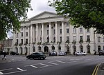 More images |
| Nos 1–6, St Margaret's Terrace and attached area railings | Cheltenham | Apartment | 1820–25 | 12 March 1955 | SO9503522734 51°54′11″N 2°04′25″W / 51.903124°N 2.073572°W / 51.903124; -2.073572 (Nos 1–6, St Margaret's Terrace and attached area railings) | 1387881 |  |
| St Paul's College Cheltenham and Gloucester College of Higher Education | Cheltenham | Further education college | 1849 | 12 March 1955 | SO9462623044 51°54′21″N 2°04′46″W / 51.905907°N 2.079522°W / 51.905907; -2.079522 (St Paul's College Cheltenham and Gloucester College of Higher Education) | 1387995 |  |
| Synagogue | Cheltenham | Synagogue | 1837–39 | 5 May 1972 | SO9455422416 51°54′01″N 2°04′50″W / 51.90026°N 2.080558°W / 51.90026; -2.080558 (Synagogue) | 1387877 | 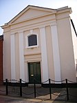 More images |
| Trident House (No 27a) and attached railings to Nos 15–21 and 27 | Cheltenham | Terrace | 1837–40 | 12 March 1955 | SO9458722269 51°53′56″N 2°04′48″W / 51.898939°N 2.080076°W / 51.898939; -2.080076 (Trident House (No 27a) and attached railings to Nos 15–21 and 27) | 1387845 | Upload Photo |
| Nos 1–2 Suffolk Square, No 1 Willoughby and attached area railings to Nos 2–12 | Cheltenham | Apartments | 1832–48 | 12 March 1955 | SO9451221657 51°53′36″N 2°04′52″W / 51.893436°N 2.081156°W / 51.893436; -2.081156 (Nos 1–2 Suffolk Square, No 1 Willoughby and attached area railings to Nos 2–12) | 1387971 |  More images |
See also
- Grade II* listed buildings in Gloucestershire
- Grade II* listed buildings in Cotswold (district)
- Grade II* listed buildings in Forest of Dean
- Grade II* listed buildings in Gloucester
- Grade II* listed buildings in South Gloucestershire
- Grade II* listed buildings in Stroud (district)
- Grade II* listed buildings in Tewkesbury (borough)
- Grade I listed buildings in Cheltenham
Notes
- ^ The date given is the date used by Historic England as significant for the initial building or that of an important part in the structure's description.
- ^ Sometimes known as OSGB36, the grid reference is based on the British national grid reference system used by the Ordnance Survey.
- ^ The "List Entry Number" is a unique number assigned to each listed building and scheduled monument by Historic England.
External links
- v
- t
- e
- Bedfordshire
- Berkshire
- Bristol
- Buckinghamshire
- Cambridgeshire
- Cheshire
- Cornwall
- Cumbria
- Derbyshire
- Devon
- Dorset
- Durham
- East Sussex
- East Riding of Yorkshire
- Essex
- Gloucestershire
- Greater London
- Greater Manchester
- Hampshire
- Herefordshire
- Hertfordshire
- Isle of Wight
- Kent
- Lancashire
- Leicestershire
- Lincolnshire
- Merseyside
- Norfolk
- North Yorkshire
- Northamptonshire
- Northumberland
- Nottinghamshire
- Oxfordshire
- Rutland
- Shropshire
- Somerset
- South Yorkshire
- Staffordshire
- Suffolk
- Surrey
- Tyne and Wear
- Warwickshire
- West Midlands
- West Sussex
- West Yorkshire
- Wiltshire
- Worcestershire
- Allerdale
- Amber Valley
- Ashford
- Babergh
- Barrow-in-Furness
- Basildon
- Basingstoke and Deane
- Bath and North East Somerset
- Bolsover
- Boston
- Bournemouth
- Bradford
- Braintree
- Breckland
- Brentwood
- Brighton and Hove
- Bristol
- Broadland
- Calderdale
- Cambridge
- Camden
- Canterbury
- Carlisle
- Castle Point
- Chelmsford
- Cheltenham
- Cherwell
- Cheshire East
- Cheshire West and Chester
- Chesterfield
- Chiltern
- Christchurch
- Colchester
- Copeland
- Corby
- Cotswold
- Craven
- Dartford
- Daventry
- Dover
- East Cambridgeshire
- Exeter
- Mendip
- North Somerset
- Poole
- Sedgemoor
- South Somerset
- Stoke-on-Trent
- Taunton Deane
- West Somerset
- York


