Grade II* listed buildings in Exeter

Map all coordinates using OpenStreetMap
Download coordinates as:
- KML
- GPX (all coordinates)
- GPX (primary coordinates)
- GPX (secondary coordinates)
There are over 20,000 Grade II* listed buildings in England. This page is a list of these buildings in the district of Exeter in Devon.
Buildings
| Name | Location | Type | Completed [note 1] | Date designated | Grid ref.[note 2] Geo-coordinates | Entry number [note 3] | Image |
|---|---|---|---|---|---|---|---|
| Bellair | Exeter | House | c. 1700 | 29 January 1953 | SX9295691709 50°42′54″N 3°31′03″W / 50.715122°N 3.517593°W / 50.715122; -3.517593 (Bellair) | 1224137 |  More images |
| Boundary Wall, Piers and Gates of Broadway House | Topsham, Exeter | Gate | 1776 | 11 November 1952 | SX9648188309 50°41′07″N 3°28′00″W / 50.685196°N 3.466727°W / 50.685196; -3.466727 (Boundary Wall, Piers and Gates of Broadway House) | 1333434 |  Upload Photo |
| Broadway House | Topsham, Exeter | House | 1776 | 11 November 1952 | SX9649088316 50°41′07″N 3°28′00″W / 50.685261°N 3.466601°W / 50.685261; -3.466601 (Broadway House) | 1103877 |  More images |
| Chapel at St Anne's Almshouses | Exeter | Chapel | 15th century | 29 January 1953 | SX9280393293 50°43′46″N 3°31′13″W / 50.729333°N 3.52022°W / 50.729333; -3.52022 (Chapel at St Anne's Almshouses) | 1380202 | 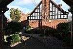 More images |
| Chichester Place | Exeter | Terrace | 1824–25 | 29 January 1953 | SX9238792676 50°43′25″N 3°31′33″W / 50.72371°N 3.525932°W / 50.72371; -3.525932 (Chichester Place) | 1223851 |  More images |
| Church House | Exeter | House | 17th century | 29 January 1953 | SX9206892501 50°43′19″N 3°31′49″W / 50.722077°N 3.530398°W / 50.722077; -3.530398 (Church House) | 1225195 | Upload Photo |
| Church of Saint Michael and All Angels | Heavitree, Exeter | Church | Medieval origins, rebuilt 1844–46 | 29 January 1953 | SX9375792266 50°43′13″N 3°30′23″W / 50.720277°N 3.506412°W / 50.720277; -3.506412 (Church of Saint Michael and All Angels) | 1333344 |  More images |
| Church of St Andrew | Exwick, Exeter | Chapel of ease | 1841–42 | 18 June 1974 | SX9085093620 50°43′55″N 3°32′53″W / 50.731909°N 3.547978°W / 50.731909; -3.547978 (Church of St Andrew) | 1223954 |  More images |
| Church of St Michael | Alphington, Exeter | Church | Late 15th century | 30 June 1961 | SX9183689982 50°41′58″N 3°31′59″W / 50.69939°N 3.532945°W / 50.69939; -3.532945 (Church of St Michael) | 1103980 |  More images |
| Church of St Michael and All Angels | Pinhoe, Exeter | Church | Late 14th to early 15th century | 30 June 1961 | SX9552094973 50°44′42″N 3°28′56″W / 50.744931°N 3.482214°W / 50.744931; -3.482214 (Church of St Michael and All Angels) | 1104037 |  More images |
| Church of St Olave | Exeter | Church | 14th century | 29 January 1953 | SX9181892466 50°43′18″N 3°32′02″W / 50.721716°N 3.533928°W / 50.721716; -3.533928 (Church of St Olave) | 1103969 |  More images |
| Church of St Pancras | Exeter | Church | 13th century | 29 January 1953 | SX9192292693 50°43′26″N 3°31′57″W / 50.723776°N 3.532522°W / 50.723776; -3.532522 (Church of St Pancras) | 1222964 | 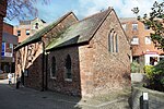 More images |
| Church of St Petrock | Exeter | Church | Early 15th century | 29 January 1953 | SX9194692576 50°43′22″N 3°31′56″W / 50.722729°N 3.532148°W / 50.722729; -3.532148 (Church of St Petrock) | 1333409 |  More images |
| Church of St Stephen | Exeter | Church | 1664 | 29 January 1953 | SX9211392722 50°43′27″N 3°31′47″W / 50.724073°N 3.529826°W / 50.724073; -3.529826 (Church of St Stephen) | 1170488 |  More images |
| Civic Hall and Higher Market | Exeter | Hall | 1838 | 18 June 1974 | SX9193992750 50°43′27″N 3°31′56″W / 50.724292°N 3.532298°W / 50.724292; -3.532298 (Civic Hall and Higher Market) | 1223245 | 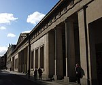 More images |
| Clara Place | Topsham, Exeter | House | 1841 | 11 November 1952 | SX9641888280 50°41′06″N 3°28′03″W / 50.684924°N 3.46761°W / 50.684924; -3.46761 (Clara Place) | 1103963 |  More images |
| Railings, Steps and Cast Iron Piers at Clara Place | Topsham, Exeter | Railings | 1841 | 11 November 1952 | SX9643288266 50°41′05″N 3°28′03″W / 50.684801°N 3.467408°W / 50.684801; -3.467408 (Railings, Steps and Cast Iron Piers at Clara Place) | 1170221 | Upload Photo |
| Cleve House | Exeter | House | Late 17th century | 29 January 1953 | SX9017393217 50°43′41″N 3°33′27″W / 50.728158°N 3.557447°W / 50.728158; -3.557447 (Cleve House) | 1306243 | Upload Photo |
| Colleton Villa | Exeter | Villa | c. 1830 | 18 June 1974 | SX9208592130 50°43′07″N 3°31′48″W / 50.718746°N 3.530049°W / 50.718746; -3.530049 (Colleton Villa) | 1333380 |  More images |
| Cowick Barton | Exeter | House | 1540 | 29 January 1953 | SX9089691112 50°42′34″N 3°32′48″W / 50.709372°N 3.546584°W / 50.709372; -3.546584 (Cowick Barton) | 1104011 |  More images |
| Cromer House | Topsham, Exeter | House | 1720 | 11 November 1952 | SX9657487965 50°40′56″N 3°27′55″W / 50.68212°N 3.465314°W / 50.68212; -3.465314 (Cromer House) | 1306102 |  More images |
| Devon and Exeter Institution | Exeter | Town house | 16th century or earlier | 29 January 1953 | SX9215592614 50°43′23″N 3°31′45″W / 50.723109°N 3.529199°W / 50.723109; -3.529199 (Devon and Exeter Institution) | 1104062 |  More images |
| Devon County Hall | St Leonards, Exeter | County hall | 1964 | 24 April 1998 | SX9295891644 50°42′52″N 3°31′03″W / 50.714538°N 3.517546°W / 50.714538; -3.517546 (Devon County Hall) | 1323701 |  More images |
| Devon County War Memorial and Processional Way | Exeter | War memorial | 1921 (Memorial), 1974 (Way) | 16 April 2009 | SX9199192567 50°43′22″N 3°31′53″W / 50.722656°N 3.531508°W / 50.722656; -3.531508 (Devon County War Memorial and Processional Way) | 1393228 | 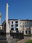 More images |
| Exeter City War Memorial | Exeter | War memorial | 1923 | 8 September 2014 | SZ0843191322 50°43′35″N 3°31′54″W / 50.726325°N 3.531664°W / 50.726325; -3.531664 (Exeter City War Memorial) | 1420669 |  More images |
| Exeter Country Club (Weare House) | Exeter | Country house | Probably c. 1804 | 29 January 1953 | SX9502689910 50°41′58″N 3°29′16″W / 50.699328°N 3.487771°W / 50.699328; -3.487771 (Exeter Country Club (Weare House)) | 1224192 | Upload Photo |
| Fish Market | Kings Beam, Exeter | Fish market | c. 1838 | 18 June 1974 | SX9201792095 50°43′06″N 3°31′52″W / 50.718418°N 3.531002°W / 50.718418; -3.531002 (Fish Market) | 1223047 | 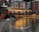 |
| Harbourmaster's Office | Exeter | Harbour Master's office | 18th century | 29 January 1953 | SX9200692144 50°43′08″N 3°31′52″W / 50.718857°N 3.531172°W / 50.718857; -3.531172 (Harbourmaster's Office) | 1223041 |  More images |
| Imperial Hotel | Exeter | House | c. 1810 | 29 January 1953 | SX9142693429 50°43′49″N 3°32′23″W / 50.7303°N 3.539763°W / 50.7303; -3.539763 (Imperial Hotel) | 1222697 |  More images |
| Iron Footbridge | Exeter | Footbridge | 1814 | 29 January 1953 | SX9226092534 50°43′21″N 3°31′40″W / 50.72241°N 3.527689°W / 50.72241; -3.527689 (Iron Footbridge) | 1333351 |  More images |
| Notaries' House | Exeter | House | Early 18th century | 29 January 1953 | SX9217292599 50°43′23″N 3°31′44″W / 50.722978°N 3.528954°W / 50.722978; -3.528954 (Notaries' House) | 1306408 |  |
| Old Matford | Wonford Rd, Exeter | House | c. 1600 | 29 January 1953 | SX9329291836 50°42′59″N 3°30′46″W / 50.716326°N 3.512872°W / 50.716326; -3.512872 (Old Matford) | 1224370 |  More images |
| Old Tudor House (Tiddy House) | Exeter | House | Late 16th century | 29 January 1953 | SX9159292287 50°43′12″N 3°32′13″W / 50.720065°N 3.537076°W / 50.720065; -3.537076 (Old Tudor House (Tiddy House)) | 1266938 |  More images |
| Pinbrook House | Exeter | Manor house | 1679 | 11 November 1952 | SX9523794560 50°44′28″N 3°29′10″W / 50.741168°N 3.486106°W / 50.741168; -3.486106 (Pinbrook House) | 1104086 |  More images |
| Polsloe Priory | Exeter | Priory | 13th century | 29 January 1953 | SX9411493814 50°44′03″N 3°30′06″W / 50.734258°N 3.501801°W / 50.734258; -3.501801 (Polsloe Priory) | 1169490 |  More images |
| Rougemont House | Exeter | House | Early 19th century | 29 January 1953 | SX9212192895 50°43′32″N 3°31′47″W / 50.725629°N 3.529763°W / 50.725629; -3.529763 (Rougemont House) | 1169610 |  More images |
| Royal Devon and Exeter Hospital | Exeter | Hospital | By 1758 | 18 June 1974 | SX9227092376 50°43′16″N 3°31′39″W / 50.720991°N 3.527501°W / 50.720991; -3.527501 (Royal Devon and Exeter Hospital) | 1267091 |  More images |
| Salutation Hotel | Topsham, Exeter | Hotel | Probably c. 1720 | 11 November 1952 | SX9655088114 50°41′00″N 3°27′57″W / 50.683456°N 3.465696°W / 50.683456; -3.465696 (Salutation Hotel) | 1103914 |  More images |
| Shell House | Topsham, Exeter | House | Late 17th century | 11 November 1952 | SX9670387724 50°40′48″N 3°27′48″W / 50.679977°N 3.463422°W / 50.679977; -3.463422 (Shell House) | 1267061 |  More images |
| Sidwell Street Methodist Church | Exeter | Methodist chapel | 31 October 1983 | SX9260593155 50°43′41″N 3°31′23″W / 50.728056°N 3.522984°W / 50.728056; -3.522984 (Sidwell Street Methodist Church) | 1224385 |  More images | |
| Southernhay House | Exeter | House | Early 19th century | 29 January 1953 | SX9234392490 50°43′19″N 3°31′35″W / 50.72203°N 3.526501°W / 50.72203; -3.526501 (Southernhay House) | 1223853 |  More images |
| St Margaret's Church | Topsham, Exeter | Church | 15th century tower | 30 June 1961 | SX9653788029 50°40′58″N 3°27′57″W / 50.682689°N 3.465856°W / 50.682689; -3.465856 (St Margaret's Church) | 1170373 |  More images |
| St Olave's Home | Exeter | House | Probably 18th century | 29 January 1953 | SX9168492538 50°43′20″N 3°32′09″W / 50.722339°N 3.535847°W / 50.722339; -3.535847 (St Olave's Home) | 1104074 | Upload Photo |
| Synagogue | Synagogue Place, Exeter | Synagogue | 1764 | 29 January 1953 | SX9181692558 50°43′21″N 3°32′02″W / 50.722543°N 3.533984°W / 50.722543; -3.533984 (Synagogue) | 1273591 |  More images |
| The Castle (Crown Court) | Exeter | Court | 1774 | 29 January 1953 | SX9208393002 50°43′36″N 3°31′49″W / 50.726584°N 3.530333°W / 50.726584; -3.530333 (The Castle (Crown Court)) | 1169617 |  More images |
| 1, The Cloisters | Exeter | House | 1762 | 29 January 1953 | SX9205892518 50°43′20″N 3°31′50″W / 50.722228°N 3.530545°W / 50.722228; -3.530545 (1, The Cloisters) | 1104025 |  |
| 2, The Cloisters | Exeter | House | 1762 | 29 January 1953 | SX9205692509 50°43′20″N 3°31′50″W / 50.722147°N 3.530571°W / 50.722147; -3.530571 (2, The Cloisters) | 1333353 | |
| The Deanery | Exeter | Deanery | Probably 15th century | 29 January 1953 | SX9201592511 50°43′20″N 3°31′52″W / 50.722158°N 3.531152°W / 50.722158; -3.531152 (The Deanery) | 1104026 | Upload Photo |
| Tuckers Hall | Exeter | Hall | 15th century | 29 January 1953 | SX9172592357 50°43′15″N 3°32′07″W / 50.720719°N 3.535213°W / 50.720719; -3.535213 (Tuckers Hall) | 1103965 |  More images |
| Warehouse Vaults (1–4, The Quay) | Exeter | Warehouse | 1825 | 29 January 1953 | SX9217491981 50°43′03″N 3°31′43″W / 50.717423°N 3.528745°W / 50.717423; -3.528745 (Warehouse Vaults (1–4, The Quay)) | 1223045 |  |
| Warehouse Vaults (6–11, The Quay) | Exeter | Warehouse | 29 January 1953 | SX9207092094 50°43′06″N 3°31′49″W / 50.718419°N 3.530251°W / 50.718419; -3.530251 (Warehouse Vaults (6–11, The Quay)) | 1223046 |  | |
| Wynard's Hospital | Exeter | Almshouse | 17th century | 29 January 1953 | SX9234892327 50°43′14″N 3°31′35″W / 50.720565°N 3.526382°W / 50.720565; -3.526382 (Wynard's Hospital) | 1239565 |  More images |
| 2, Cathedral Close | Exeter | Timber-framed house | 17th century or earlier | 29 January 1953 | SX9210892645 50°43′24″N 3°31′48″W / 50.723379°N 3.529874°W / 50.723379; -3.529874 (2, Cathedral Close) | 1333329 |  |
| 3, Cathedral Close | Exeter | Timber-framed house | 17th century or earlier | 29 January 1953 | SX9211292642 50°43′24″N 3°31′47″W / 50.723353°N 3.529816°W / 50.723353; -3.529816 (3, Cathedral Close) | 1169629 | |
| 4, Cathedral Close | Exeter | Timber-framed house | 17th century or earlier | 29 January 1953 | SX9211692639 50°43′24″N 3°31′47″W / 50.723327°N 3.529759°W / 50.723327; -3.529759 (4, Cathedral Close) | 1104061 | |
| 6, Cathedral Close | Exeter | House | 18th century or earlier | 29 January 1953 | SX9213792625 50°43′24″N 3°31′46″W / 50.723205°N 3.529457°W / 50.723205; -3.529457 (6, Cathedral Close) | 1333330 |  More images |
| 15 and 15a, Cathedral Close | Exeter | House | c. 1740 | 29 January 1953 | SX9219192555 50°43′21″N 3°31′43″W / 50.722586°N 3.528672°W / 50.722586; -3.528672 (15 and 15a, Cathedral Close) | 1104021 | Upload Photo |
| 40, High Street | Exeter | House | Late 17th century | 29 January 1953 | SX9205292673 50°43′25″N 3°31′50″W / 50.723621°N 3.530675°W / 50.723621; -3.530675 (40, High Street) | 1103897 | Upload Photo |
| 41 and 42 High Street | Exeter | Timber-framed house | 1564 | 29 January 1953 | SX9204792667 50°43′25″N 3°31′51″W / 50.723566°N 3.530744°W / 50.723566; -3.530744 (41 and 42 High Street) | 1170491 |  More images |
| 46, High Street | Exeter | Timber-framed house | 16th century or earlier | 29 January 1953 | SX9203392655 50°43′24″N 3°31′51″W / 50.723455°N 3.530939°W / 50.723455; -3.530939 (46, High Street) | 1103899 | Upload Photo |
| 225 and 226, High Street | Exeter | House | Reputedly built 1567 | 29 January 1953 | SX9203992722 50°43′27″N 3°31′51″W / 50.724059°N 3.530874°W / 50.724059; -3.530874 (225 and 226, High Street) | 1170556 |  More images |
| 227, High Street | Exeter | House | Mid 17th century | 29 January 1953 | SX9205092729 50°43′27″N 3°31′51″W / 50.724124°N 3.53072°W / 50.724124; -3.53072 (227, High Street) | 1103907 | 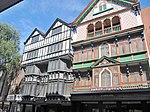 More images |
| 26, The Strand | Topsham, Exeter | Merchant's house | Late 17th century | 11 November 1952 | SX9675587641 50°40′45″N 3°27′46″W / 50.67924°N 3.462663°W / 50.67924; -3.462663 (26, The Strand) | 1224027 |  |
| Wall and Gates of No 26, The Strand | Topsham, Exeter | Gate | 18th century | 11 November 1952 | SX9674387632 50°40′45″N 3°27′46″W / 50.679157°N 3.46283°W / 50.679157; -3.46283 (Wall and Gates of No 26, The Strand) | 1267065 | |
| 27, The Strand | Topsham, Exeter | Merchant's house | Late 17th century | 11 November 1952 | SX9675487627 50°40′45″N 3°27′46″W / 50.679114°N 3.462673°W / 50.679114; -3.462673 (27, The Strand) | 1224066 |  |
| Wall and Gates of No 27, The Strand | Topsham, Exeter | Gate | 18 June 1974 | SX9674987619 50°40′45″N 3°27′46″W / 50.679041°N 3.462741°W / 50.679041; -3.462741 (Wall and Gates of No 27, The Strand) | 1266994 | Upload Photo | |
| 28, The Strand | Topsham, Exeter | Counting house | Late 17th century | 11 November 1952 | SX9675787617 50°40′44″N 3°27′45″W / 50.679024°N 3.462628°W / 50.679024; -3.462628 (28, The Strand) | 1224068 | |
| 34, The Strand | Topsham, Exeter | Merchant's house | Late 17th century | 11 November 1952 | SX9677487581 50°40′43″N 3°27′45″W / 50.678704°N 3.462377°W / 50.678704; -3.462377 (34, The Strand) | 1224070 | Upload Photo |
| No 40, The Strand (the Dutch House) including the Garage and the Dutch House | Topsham, Exeter | Merchant's house | Late 17th century | 11 November 1952 | SX9680087505 50°40′41″N 3°27′43″W / 50.678025°N 3.461988°W / 50.678025; -3.461988 (No 40, The Strand (the Dutch House) including the Garage and the Dutch House) | 1224078 | Upload Photo |
| Wall and Piers of No 40, The Strand | Topsham, Exeter | Wall | 18th century | 18 June 1974 | SX9679287498 50°40′41″N 3°27′44″W / 50.677961°N 3.462099°W / 50.677961; -3.462099 (Wall and Piers of No 40, The Strand) | 1224110 | Upload Photo |
| 1, Upper Paul Street | Exeter | House | Early 18th century | 29 January 1953 | SX9197792826 50°43′30″N 3°31′54″W / 50.724982°N 3.531782°W / 50.724982; -3.531782 (1, Upper Paul Street) | 1224196 | Upload Photo |
| 1–5, Pennsylvania Crescent | Exeter | Villa | c. 1820 | 29 January 1953 | SX9241793670 50°43′58″N 3°31′33″W / 50.732651°N 3.525797°W / 50.732651; -3.525797 (1–5, Pennsylvania Crescent) | 1222965 |  |
| 1–10, Southernhay West | Exeter | Terrace | Early 19th century | 29 January 1953 | SX9226892484 50°43′19″N 3°31′39″W / 50.721962°N 3.527561°W / 50.721962; -3.527561 (1–10, Southernhay West) | 1223945 |  |
| 13–24, Southernhay West | Exeter | House | 29 January 1953 | SX9229792574 50°43′22″N 3°31′38″W / 50.722776°N 3.527177°W / 50.722776; -3.527177 (13–24, Southernhay West) | 1267058 | 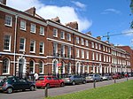 | |
| 1–6, Pennsylvania Park | Exeter | Terrace | 1823 | 29 January 1953 | SX9275394316 50°44′19″N 3°31′16″W / 50.73852°N 3.521226°W / 50.73852; -3.521226 (1–6, Pennsylvania Park) | 1222966 |  |
| 12 and 14, Magdalen Road | Exeter | House | 1830–40 | 29 January 1953 | SX9268092344 50°43′15″N 3°31′18″W / 50.72078°N 3.521686°W / 50.72078; -3.521686 (12 and 14, Magdalen Road) | 1239511 | Upload Photo |
| 21, The Mint | Exeter | Priory building | 15th century | 29 January 1953 | SX9174792501 50°43′19″N 3°32′06″W / 50.722018°N 3.534944°W / 50.722018; -3.534944 (21, The Mint) | 1239753 | Upload Photo |
| 67, South Street | Exeter | Timber-framed house | Probably early 17th century | 29 January 1953 | SX9205192346 50°43′14″N 3°31′50″W / 50.720681°N 3.530594°W / 50.720681; -3.530594 (67, South Street) | 1267088 |  More images |
| 2–6, Barnfield Crescent | Exeter | Terrace | 1805 | 29 January 1953 | SX9244592644 50°43′24″N 3°31′30″W / 50.723433°N 3.525101°W / 50.723433; -3.525101 (2–6, Barnfield Crescent) | 1306533 |  |
| 13–15, Dix's Field | Exeter | House | c. 1810 | 29 January 1953 | SX9251492703 50°43′26″N 3°31′27″W / 50.723976°N 3.524141°W / 50.723976; -3.524141 (13–15, Dix's Field) | 1333372 |  |
| 151–155, Magdalen Road | Exeter | House | c. 1810 | 29 January 1953 | SX9336992457 50°43′19″N 3°30′43″W / 50.721922°N 3.511962°W / 50.721922; -3.511962 (151–155, Magdalen Road) | 1239559 |  More images |
| 1–9, Colleton Crescent | Exeter | Terrace | c. 1805 | 29 January 1953 | SX9217392061 50°43′05″N 3°31′44″W / 50.718142°N 3.528783°W / 50.718142; -3.528783 (1–9, Colleton Crescent) | 1104007 |  More images |
| 1 and 2, Catherine Street | Exeter | House | Probably 15th century | 29 January 1953 | SX9208992661 50°43′25″N 3°31′49″W / 50.72352°N 3.530148°W / 50.72352; -3.530148 (1 and 2, Catherine Street) | 1104031 |  |
| 5 and 7, West Street | Exeter | Timber-framed house | Probably 15th century | 29 January 1953 | SX9177492259 50°43′11″N 3°32′04″W / 50.719847°N 3.534491°W / 50.719847; -3.534491 (5 and 7, West Street) | 1266893 |  More images |
| 34–40, Wonford Road | Exeter | House | c. 1840 | 29 January 1953 | SX9270292220 50°43′11″N 3°31′17″W / 50.719669°N 3.521338°W / 50.719669; -3.521338 (34–40, Wonford Road) | 1266873 |  |
See also
Notes
- ^ The date given is the date used by Historic England as significant for the initial building or that of an important part in the structure's description.
- ^ Sometimes known as OSGB36, the grid reference is based on the British national grid reference system used by the Ordnance Survey.
- ^ The "List Entry Number" is a unique number assigned to each listed building and scheduled monument by Historic England.
External links
- v
- t
- e
- Bedfordshire
- Berkshire
- Bristol
- Buckinghamshire
- Cambridgeshire
- Cheshire
- Cornwall
- Cumbria
- Derbyshire
- Devon
- Dorset
- Durham
- East Sussex
- East Riding of Yorkshire
- Essex
- Gloucestershire
- Greater London
- Greater Manchester
- Hampshire
- Herefordshire
- Hertfordshire
- Isle of Wight
- Kent
- Lancashire
- Leicestershire
- Lincolnshire
- Merseyside
- Norfolk
- North Yorkshire
- Northamptonshire
- Northumberland
- Nottinghamshire
- Oxfordshire
- Rutland
- Shropshire
- Somerset
- South Yorkshire
- Staffordshire
- Suffolk
- Surrey
- Tyne and Wear
- Warwickshire
- West Midlands
- West Sussex
- West Yorkshire
- Wiltshire
- Worcestershire
- Allerdale
- Amber Valley
- Ashford
- Babergh
- Barrow-in-Furness
- Basildon
- Basingstoke and Deane
- Bath and North East Somerset
- Bolsover
- Boston
- Bournemouth
- Bradford
- Braintree
- Breckland
- Brentwood
- Brighton and Hove
- Bristol
- Broadland
- Calderdale
- Cambridge
- Camden
- Canterbury
- Carlisle
- Castle Point
- Chelmsford
- Cheltenham
- Cherwell
- Cheshire East
- Cheshire West and Chester
- Chesterfield
- Chiltern
- Christchurch
- Colchester
- Copeland
- Corby
- Cotswold
- Craven
- Dartford
- Daventry
- Dover
- East Cambridgeshire
- Exeter
- Mendip
- North Somerset
- Poole
- Sedgemoor
- South Somerset
- Stoke-on-Trent
- Taunton Deane
- West Somerset
- York


