National Register of Historic Places listings in Clarion County, Pennsylvania
This is a list of the National Register of Historic Places listings in Clarion County, Pennsylvania.
This is intended to be a complete list of the properties and districts on the National Register of Historic Places in Clarion County, Pennsylvania, United States. The locations of National Register properties and districts for which the latitude and longitude coordinates are included below, may be seen in a map.[1]
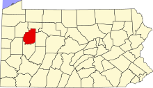
There are six properties and districts listed on the National Register in the county.
This National Park Service list is complete through NPS recent listings posted April 12, 2024.[2]
Map all coordinates using OpenStreetMap
Download coordinates as:
- KML
- GPX (all coordinates)
- GPX (primary coordinates)
- GPX (secondary coordinates)
Current listings
| [3] | Name on the Register | Image | Date listed[4] | Location | City or town | Description |
|---|---|---|---|---|---|---|
| 1 | Buchanan Furnace |  | September 6, 1991 (#91001129) | Off Pennsylvania Route 378 at the Clarion River 41°07′54″N 79°33′32″W / 41.131667°N 79.558889°W / 41.131667; -79.558889 (Buchanan Furnace) | Licking Township | |
| 2 | Clarion County Courthouse and Jail |  | May 22, 1979 (#79002208) | Main Street 41°12′55″N 79°23′09″W / 41.215278°N 79.385833°W / 41.215278; -79.385833 (Clarion County Courthouse and Jail) | Clarion | |
| 3 | Cook Forest State Park Indian Cabin District | 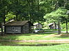 | February 12, 1987 (#87000019) | Off Pennsylvania Route 36 at Cooksburg 41°20′02″N 79°12′32″W / 41.333889°N 79.208889°W / 41.333889; -79.208889 (Cook Forest State Park Indian Cabin District) | Farmington Township | Extends into Forest County |
| 4 | Foxburg Country Club and Golf Course |  | February 21, 2007 (#07000076) | 369 Harvey Road 41°09′00″N 79°40′45″W / 41.15°N 79.679167°W / 41.15; -79.679167 (Foxburg Country Club and Golf Course) | Foxburg | |
| 5 | Memorial Church of Our Father | Upload image | March 31, 2022 (#100007547) | 110 Church St. 41°08′44″N 79°40′49″W / 41.1456°N 79.6802°W / 41.1456; -79.6802 (Memorial Church of Our Father) | Foxburg | |
| 6 | Sutton-Ditz House |  | February 20, 2004 (#04000063) | 18 Grant Street 41°12′50″N 79°23′12″W / 41.213889°N 79.386667°W / 41.213889; -79.386667 (Sutton-Ditz House) | Clarion |
See also
Wikimedia Commons has media related to National Register of Historic Places in Clarion County, Pennsylvania.
- List of National Historic Landmarks in Pennsylvania
- National Register of Historic Places listings in Pennsylvania
- List of Pennsylvania state historical markers in Clarion County
References
- ^ The latitude and longitude information provided in this table was derived originally from the National Register Information System, which has been found to be fairly accurate for about 99% of listings. Some locations in this table may have been corrected to current GPS standards.
- ^ National Park Service, United States Department of the Interior, "National Register of Historic Places: Weekly List Actions", retrieved April 12, 2024.
- ^ Numbers represent an alphabetical ordering by significant words. Various colorings, defined here, differentiate National Historic Landmarks and historic districts from other NRHP buildings, structures, sites or objects.
- ^ The eight-digit number below each date is the number assigned to each location in the National Register Information System database, which can be viewed by clicking the number.
- v
- t
- e

- Adams
- Allegheny
- Armstrong
- Beaver
- Bedford
- Berks
- Blair
- Bradford
- Bucks
- Butler
- Cambria
- Cameron
- Carbon
- Centre
- Chester
- Clarion
- Clearfield
- Clinton
- Columbia
- Crawford
- Cumberland
- Dauphin
- Delaware
- Elk
- Erie
- Fayette
- Forest
- Franklin
- Fulton
- Greene
- Huntingdon
- Indiana
- Jefferson
- Juniata
- Lackawanna
- Lancaster
- Lawrence
- Lebanon
- Lehigh
- Luzerne
- Lycoming
- McKean
- Mercer
- Mifflin
- Monroe
- Montgomery
- Montour
- Northampton
- Northumberland
- Perry
- Philadelphia
- Pike
- Potter
- Schuylkill
- Snyder
- Somerset
- Sullivan
- Susquehanna
- Tioga
- Union
- Venango
- Warren
- Washington
- Wayne
- Westmoreland
- Wyoming
- York
 Category
 NRHP portal


Municipalities and communities of Clarion County, Pennsylvania, United States | ||
|---|---|---|
County seat: Clarion | ||
| Boroughs |  | |
| Townships | ||
| CDPs | ||
| Unincorporated communities | ||
| Footnotes | ‡This populated place also has portions in an adjacent county or counties | |
| ||


