National Register of Historic Places listings in Wayne County, Pennsylvania
This is a list of the National Register of Historic Places listings in Wayne County, Pennsylvania.
This is intended to be a complete list of the properties and districts on the National Register of Historic Places in Wayne County, Pennsylvania, United States. The locations of National Register properties and districts for which the latitude and longitude coordinates are included below, may be seen in a map.[1]
There are 17 properties and districts listed on the National Register in the county. One site is further designated as a National Historic Landmark.
This National Park Service list is complete through NPS recent listings posted April 12, 2024.[2]
Map all coordinates using OpenStreetMap
Download coordinates as:
- KML
- GPX (all coordinates)
- GPX (primary coordinates)
- GPX (secondary coordinates)
Current listings
| [3] | Name on the Register | Image | Date listed[4] | Location | Municipality | Description |
|---|---|---|---|---|---|---|
| 1 | Bellemonte Silk Mill |  | June 28, 2010 (#10000407) | 230 Welwood Ave. 41°28′19″N 75°10′20″W / 41.471944°N 75.172222°W / 41.471944; -75.172222 (Bellemonte Silk Mill) | Hawley | |
| 2 | Bridge in Dreher Township | 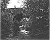 | June 22, 1988 (#88000871) | Legislative Route 171 over Haags Mill Creek 41°17′17″N 75°19′52″W / 41.288056°N 75.331111°W / 41.288056; -75.331111 (Bridge in Dreher Township) | Dreher Township | |
| 3 | Damascus Historic District |  | August 14, 1992 (#92001000) | Roughly Pennsylvania Route 371 from Galilee Road to the Delaware River and adjacent part of Route 63027 south of Pennsylvania Route 371 41°42′37″N 75°04′15″W / 41.710278°N 75.070833°W / 41.710278; -75.070833 (Damascus Historic District) | Damascus Township | |
| 4 | Delaware and Hudson Canal | 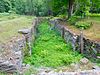 | November 24, 1968 (#68000051) | Delaware and Hudson Canal 41°34′20″N 75°15′21″W / 41.572222°N 75.255833°W / 41.572222; -75.255833 (Delaware and Hudson Canal) | Honesdale | Extends into Pike County; Wayne County component is the company's former offices in Honesdale[5] |
| 5 | Eugene Dorflinger Estate |  | September 18, 1978 (#78002483) | U.S. Route 6 and Charles Street in White Mills 41°31′32″N 75°12′12″W / 41.525556°N 75.203333°W / 41.525556; -75.203333 (Eugene Dorflinger Estate) | Texas Township | |
| 6 | Equinunk Historic District |  | November 12, 1999 (#99001336) | Generally following Pennsylvania Route 191, Pine Mill, Lordville, and Grocery Hill Roads in Equinunk 41°51′18″N 75°13′37″W / 41.855°N 75.226944°W / 41.855; -75.226944 (Equinunk Historic District) | Buckingham and Manchester Townships | |
| 7 | Hill's Sawmill |  | November 8, 1974 (#74001816) | South of Equinunk off Pennsylvania Route 191 41°45′09″N 75°11′36″W / 41.7525°N 75.193333°W / 41.7525; -75.193333 (Hill's Sawmill) | Damascus Township | |
| 8 | Honesdale Residential Historic District |  | February 6, 1998 (#97001670) | Roughly bounded by the Lackawaxen River, Dyberry Creek, the Dyberry Cemetery, and Overlook and 18th Streets 41°34′51″N 75°15′35″W / 41.580833°N 75.259722°W / 41.580833; -75.259722 (Honesdale Residential Historic District) | Honesdale | |
| 9 | Lacawac |  | August 9, 1979 (#79002367) | East of Ledgedale 41°22′43″N 75°17′40″W / 41.378611°N 75.294444°W / 41.378611; -75.294444 (Lacawac) | Paupack and Salem Townships | |
| 10 | Milanville Historic District |  | April 29, 1993 (#93000352) | Roughly Legislative Route 63027 from the junction with Legislative Route 63029 east to Skinner's Falls Bridge via Bridge Approach Road, in Milanville 41°40′16″N 75°03′48″W / 41.671111°N 75.063333°W / 41.671111; -75.063333 (Milanville Historic District) | Damascus Township | |
| 11 | Milanville-Skinners Falls Bridge | 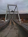 | November 14, 1988 (#88002167) | Legislative Route 63027 over the Delaware River at Milanville 41°40′10″N 75°03′31″W / 41.669444°N 75.058611°W / 41.669444; -75.058611 (Milanville-Skinners Falls Bridge) | Damascus Township | Extends into Cochecton in Sullivan County, New York |
| 12 | J.S. O'Connor American Rich Cut Glassware Factory |  | March 23, 2005 (#05000206) | 120 Falls Avenue 41°28′31″N 75°10′17″W / 41.475278°N 75.171389°W / 41.475278; -75.171389 (J.S. O'Connor American Rich Cut Glassware Factory) | Hawley | |
| 13 | Octagon Stone Schoolhouse |  | May 6, 1977 (#77001200) | 1 mile (1.6 km) southwest of South Canaan 41°29′42″N 75°25′53″W / 41.495°N 75.431389°W / 41.495; -75.431389 (Octagon Stone Schoolhouse) | South Canaan Township | |
| 14 | Patriotic Order Sons of America Washington Camp 422 |  | December 27, 2010 (#10001068) | 465 South Sterling Road 41°16′28″N 75°20′11″W / 41.274361°N 75.336389°W / 41.274361; -75.336389 (Patriotic Order Sons of America Washington Camp 422) | Dreher Township | |
| 15 | Starlight Station, New York, Ontario, and Western Railway |  | August 30, 2001 (#01000925) | O&W Road northeast of Depot Hill Road, Starlight 41°54′14″N 75°19′46″W / 41.903889°N 75.329444°W / 41.903889; -75.329444 (Starlight Station, New York, Ontario, and Western Railway) | Buckingham Township | |
| 16 | Wilmot House |  | February 15, 1974 (#74001815) | Wayne Street 41°36′46″N 75°17′03″W / 41.612778°N 75.284167°W / 41.612778; -75.284167 (Wilmot House) | Bethany | |
| 17 | Wilmot Mansion |  | January 26, 1978 (#78003172) | Wayne and Sugar Streets 41°36′47″N 75°17′06″W / 41.613056°N 75.285°W / 41.613056; -75.285 (Wilmot Mansion) | Bethany |
Former listing
| [3] | Name on the Register | Image | Date listed | Date removed | Location | Municipality | Description |
|---|---|---|---|---|---|---|---|
| 1 | Stone Arch Bridge | Upload image | October 21, 1977 (#77001201) | June 27, 1986 | Starrucca Creek | Starrucca |
See also
Wikimedia Commons has media related to National Register of Historic Places in Wayne County, Pennsylvania.
References
- ^ The latitude and longitude information provided in this table was derived originally from the National Register Information System, which has been found to be fairly accurate for about 99% of listings. Some locations in this table may have been corrected to current GPS standards.
- ^ National Park Service, United States Department of the Interior, "National Register of Historic Places: Weekly List Actions", retrieved April 12, 2024.
- ^ a b Numbers represent an alphabetical ordering by significant words. Various colorings, defined here, differentiate National Historic Landmarks and historic districts from other NRHP buildings, structures, sites or objects.
- ^ The eight-digit number below each date is the number assigned to each location in the National Register Information System database, which can be viewed by clicking the number.
- ^ McDermott, John D., and Patty Henry. National Historic Landmark Nomination: Delaware and Hudson Canal. National Park Service, 2008-03-14, 13. Accessed 2016-01-17.
- v
- t
- e

- Adams
- Allegheny
- Armstrong
- Beaver
- Bedford
- Berks
- Blair
- Bradford
- Bucks
- Butler
- Cambria
- Cameron
- Carbon
- Centre
- Chester
- Clarion
- Clearfield
- Clinton
- Columbia
- Crawford
- Cumberland
- Dauphin
- Delaware
- Elk
- Erie
- Fayette
- Forest
- Franklin
- Fulton
- Greene
- Huntingdon
- Indiana
- Jefferson
- Juniata
- Lackawanna
- Lancaster
- Lawrence
- Lebanon
- Lehigh
- Luzerne
- Lycoming
- McKean
- Mercer
- Mifflin
- Monroe
- Montgomery
- Montour
- Northampton
- Northumberland
- Perry
- Philadelphia
- Pike
- Potter
- Schuylkill
- Snyder
- Somerset
- Sullivan
- Susquehanna
- Tioga
- Union
- Venango
- Warren
- Washington
- Wayne
- Westmoreland
- Wyoming
- York
 Category
 NRHP portal


Municipalities and communities of Wayne County, Pennsylvania, United States | ||
|---|---|---|
County seat: Honesdale | ||
| Boroughs |  | |
| Townships | ||
| CDPs | ||
| Other communities | ||
| Footnotes | ‡This populated place also has portions in an adjacent county or counties | |
| ||


