National Register of Historic Places listings in Sullivan County, Pennsylvania
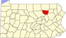
This is a list of the National Register of Historic Places listings in Sullivan County, Pennsylvania.
This is intended to be a complete list of the properties and districts on National Register of Historic Places in Sullivan County, Pennsylvania. The locations of National Register properties and districts for which the latitude and longitude coordinates are included below, may be seen in a map.[1]
There are 7 properties and districts listed on the National Register in the county.
This National Park Service list is complete through NPS recent listings posted April 12, 2024.[2]
Map all coordinates using OpenStreetMap
Download coordinates as:
- KML
- GPX (all coordinates)
- GPX (primary coordinates)
- GPX (secondary coordinates)
Current listings
| [3] | Name on the Register | Image | Date listed[4] | Location | City or town | Description |
|---|---|---|---|---|---|---|
| 1 | Eagles Mere Historic District |  | June 28, 1996 (#96000718) | Roughly bounded by Pennsylvania Route 42, Borough boundary, Loyalsock State Forest and Eagles Mere Golf Club 41°25′02″N 76°34′36″W / 41.417222°N 76.576667°W / 41.417222; -76.576667 (Eagles Mere Historic District) | Eagles Mere and Shrewsbury Township | Boundary increase on September 18, 2013. |
| 2 | Forksville Covered Bridge |  | July 24, 1980 (#80003639) | Legislative Route 56007 spur 41°29′18″N 76°36′00″W / 41.488333°N 76.6°W / 41.488333; -76.6 (Forksville Covered Bridge) | Forksville | |
| 3 | Hillsgrove Covered Bridge |  | July 2, 1973 (#73001666) | 3 miles (4.8 km) east of Hillsgrove off Pennsylvania Route 87 over Loyalsock Creek 41°27′39″N 76°40′17″W / 41.460833°N 76.671389°W / 41.460833; -76.671389 (Hillsgrove Covered Bridge) | Hillsgrove Township | |
| 4 | Clemuel Ricketts Mansion |  | June 9, 1983 (#83002284) | Off Pennsylvania Route 487 41°21′08″N 76°19′14″W / 41.352222°N 76.320556°W / 41.352222; -76.320556 (Clemuel Ricketts Mansion) | Colley Township | |
| 5 | Sonestown Covered Bridge |  | July 24, 1980 (#80003640) | South of Sonestown on Township 310 41°20′47″N 76°33′19″W / 41.346389°N 76.555278°W / 41.346389; -76.555278 (Sonestown Covered Bridge) | Davidson Township | |
| 6 | Sullivan County Courthouse | 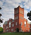 | December 15, 1978 (#78002472) | Main and Muncy Streets 41°25′25″N 76°29′39″W / 41.423611°N 76.494167°W / 41.423611; -76.494167 (Sullivan County Courthouse) | Laporte | |
| 7 | Worlds End State Park Family Cabin District |  | May 18, 1987 (#87000742) | 2 miles (3.2 km) southeast of Forksville on Pennsylvania Route 154 41°28′02″N 76°34′35″W / 41.467222°N 76.576389°W / 41.467222; -76.576389 (Worlds End State Park Family Cabin District) | Forks Township |
See also
Wikimedia Commons has media related to National Register of Historic Places in Sullivan County, Pennsylvania.
References
- ^ The latitude and longitude information provided in this table was derived originally from the National Register Information System, which has been found to be fairly accurate for about 99% of listings. Some locations in this table may have been corrected to current GPS standards.
- ^ National Park Service, United States Department of the Interior, "National Register of Historic Places: Weekly List Actions", retrieved April 12, 2024.
- ^ Numbers represent an alphabetical ordering by significant words. Various colorings, defined here, differentiate National Historic Landmarks and historic districts from other NRHP buildings, structures, sites or objects.
- ^ The eight-digit number below each date is the number assigned to each location in the National Register Information System database, which can be viewed by clicking the number.
- v
- t
- e

- Adams
- Allegheny
- Armstrong
- Beaver
- Bedford
- Berks
- Blair
- Bradford
- Bucks
- Butler
- Cambria
- Cameron
- Carbon
- Centre
- Chester
- Clarion
- Clearfield
- Clinton
- Columbia
- Crawford
- Cumberland
- Dauphin
- Delaware
- Elk
- Erie
- Fayette
- Forest
- Franklin
- Fulton
- Greene
- Huntingdon
- Indiana
- Jefferson
- Juniata
- Lackawanna
- Lancaster
- Lawrence
- Lebanon
- Lehigh
- Luzerne
- Lycoming
- McKean
- Mercer
- Mifflin
- Monroe
- Montgomery
- Montour
- Northampton
- Northumberland
- Perry
- Philadelphia
- Pike
- Potter
- Schuylkill
- Snyder
- Somerset
- Sullivan
- Susquehanna
- Tioga
- Union
- Venango
- Warren
- Washington
- Wayne
- Westmoreland
- Wyoming
- York
 Category
 NRHP portal


Municipalities and communities of Sullivan County, Pennsylvania, United States | ||
|---|---|---|
County seat: Laporte | ||
| Boroughs |  | |
| Townships | ||
| Unincorporated communities | ||
| Ghost town | ||
| ||


