National Register of Historic Places listings in Washington County, Pennsylvania

This is a list of the National Register of Historic Places listings in Washington County, Pennsylvania.
This is intended to be a complete list of the properties and districts on the National Register of Historic Places in Washington County, Pennsylvania, United States. The locations of National Register properties and districts for which the latitude and longitude coordinates are included below, may be seen in a map.[1]
There are 99 properties and districts listed on the National Register in the county. Four sites are further designated as National Historic Landmarks.
This National Park Service list is complete through NPS recent listings posted April 12, 2024.[2]
Map all coordinates using OpenStreetMap
Download coordinates as:
- KML
- GPX (all coordinates)
- GPX (primary coordinates)
- GPX (secondary coordinates)
Current listings
| [3] | Name on the Register | Image | Date listed[4] | Location | City or town | Description |
|---|---|---|---|---|---|---|
| 1 | Edward G. Acheson House |  | May 11, 1976 (#76001679) | 908 Main Street 40°12′19″N 79°55′59″W / 40.205278°N 79.933056°W / 40.205278; -79.933056 (Edward G. Acheson House) | Monongahela | |
| 2 | Administration Building, Washington and Jefferson College |  | August 16, 1977 (#77001199) | Washington & Jefferson College campus 40°10′13″N 80°14′28″W / 40.170361°N 80.241111°W / 40.170361; -80.241111 (Administration Building, Washington and Jefferson College) | Washington | |
| 3 | Bailey Covered Bridge | 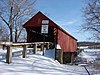 | June 22, 1979 (#79002355) | Bailey Road spanning Ten Mile Creek, southeast of Prosperity 40°01′14″N 80°11′45″W / 40.020556°N 80.195833°W / 40.020556; -80.195833 (Bailey Covered Bridge) | Amwell Township | |
| 4 | Beallsville Historic District |  | October 24, 1996 (#96001205) | Roughly, Main Street, Chestnut Alley, and South Alley between West Alley and Oak Alley 40°03′54″N 80°01′23″W / 40.065°N 80.023056°W / 40.065; -80.023056 (Beallsville Historic District) | Beallsville | |
| 5 | Bethel African Methodist Episcopal Church of Monongahela City |  | November 7, 2002 (#02001298) | Junction of 7th and Main Streets 40°12′19″N 79°55′52″W / 40.205278°N 79.931°W / 40.205278; -79.931 (Bethel African Methodist Episcopal Church of Monongahela City) | Monongahela | |
| 6 | David Bradford House |  | July 16, 1973 (#73001668) | 175 South Main Street 40°10′05″N 80°14′42″W / 40.168056°N 80.245°W / 40.168056; -80.245 (David Bradford House) | Washington | |
| 7 | Samuel Brownlee House |  | November 7, 1976 (#76001678) | North of Eighty-Four on Pennsylvania Route 519 40°12′24″N 80°07′41″W / 40.206667°N 80.128056°W / 40.206667; -80.128056 (Samuel Brownlee House) | North Strabane Township | |
| 8 | Scott Brownlee Covered Bridge | 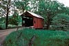 | June 22, 1979 (#79002360) | Off Pennsylvania Route 231 40°02′38″N 80°23′53″W / 40.043889°N 80.398056°W / 40.043889; -80.398056 (Scott Brownlee Covered Bridge) | East Finley Township | |
| 9 | Brownsville Bridge |  | June 22, 1988 (#88000834) | State Route 4025 over the Monongahela River 40°01′20″N 79°53′26″W / 40.022222°N 79.890556°W / 40.022222; -79.890556 (Brownsville Bridge) | West Brownsville | Extends into Fayette County |
| 10 | Caldwell Tavern | 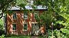 | February 16, 1996 (#96000087) | Junction of U.S. Route 40 and Township Route 474, northeast of Claysville 40°08′21″N 80°21′36″W / 40.139167°N 80.36°W / 40.139167; -80.36 (Caldwell Tavern) | Buffalo Township | |
| 11 | Canonsburg Armory | 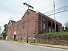 | December 22, 1989 (#89002070) | West College Street and North Central Avenue 40°15′37″N 80°11′14″W / 40.260353°N 80.187356°W / 40.260353; -80.187356 (Canonsburg Armory) | Canonsburg | |
| 12 | Cement City Historic District |  | February 16, 1996 (#96000023) | Roughly Chestnut and Walnut Streets from Modisette Avenue to Bertha Avenue and along Ida and Bertha Streets 40°10′15″N 79°51′56″W / 40.170833°N 79.865556°W / 40.170833; -79.865556 (Cement City Historic District) | Donora | |
| 13 | Centerville Historic District | 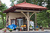 | October 24, 1996 (#96001208) | Roughly Old National Pike from Linton Road to its junction with Pennsylvania Route 481 40°02′42″N 79°58′35″W / 40.045°N 79.976389°W / 40.045; -79.976389 (Centerville Historic District) | Centerville | |
| 14 | Charleroi Historic District |  | November 9, 2007 (#07001162) | Roughly bounded by 1st and 13th Streets, Oakland Avenue, and the former Pennsylvania Railroad tracks 40°08′N 79°54′W / 40.14°N 79.9°W / 40.14; -79.9 (Charleroi Historic District) | Charleroi | |
| 15 | Charleroi-Monessen Bridge | 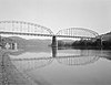 | June 22, 1988 (#88000812) | State Route 2018 over the Monongahela River 40°09′06″N 79°54′15″W / 40.151667°N 79.904167°W / 40.151667; -79.904167 (Charleroi-Monessen Bridge) | North Charleroi | Extends into Monessen in Westmoreland County |
| 16 | Crawford Covered Bridge |  | June 22, 1979 (#79002361) | Crawford Road spanning Robinson Fork Wheeling Creek[5] 39°59′56″N 80°28′21″W / 39.9989°N 80.4725°W / 39.9989; -80.4725 (Crawford Covered Bridge) | West Finley Township | |
| 17 | Dager-Wonsettler Farmstead |  | November 21, 2003 (#03001192) | 1044 National Park, 0.5 miles (0.80 km) northwest of the junction of Pennsylvania Route 519 and U.S. Route 40 40°07′49″N 80°08′51″W / 40.130278°N 80.1475°W / 40.130278; -80.1475 (Dager-Wonsettler Farmstead) | Amwell Township | |
| 18 | Danley Covered Bridge |  | June 22, 1979 (#79002362) | Dogwood Hill Road spanning Robinson Fork Wheeling Creek[5] 40°03′18″N 80°26′22″W / 40.055°N 80.4394°W / 40.055; -80.4394 (Danley Covered Bridge) | West Finley Township | |
| 19 | Horn Davis Overholtzer Bridge |  | June 22, 1979 (#79002354) | Spanning Ten Mile Creek southeast of Fairfield 40°00′29″N 80°03′45″W / 40.008056°N 80.0625°W / 40.008056; -80.0625 (Horn Davis Overholtzer Bridge) | West Bethlehem Township | The bridge collapsed in 1994. It extended into Morgan Township in Greene County |
| 20 | Day Covered Bridge |  | June 22, 1979 (#79002356) | Covered Bridge Road spanning Short Creek, south of Prosperity[5] 40°01′46″N 80°17′35″W / 40.0294°N 80.2931°W / 40.0294; -80.2931 (Day Covered Bridge) | Morris Township | |
| 21 | Margaret Derrow House |  | November 5, 1974 (#74001808) | West Main Street, west of the Claysville borough limits 40°06′56″N 80°24′59″W / 40.115556°N 80.416389°W / 40.115556; -80.416389 (Margaret Derrow House) | Donegal Township | |
| 22 | Devil's Den, McClurg Covered Bridge |  | June 22, 1979 (#79003828) | Hanover Township park 40°25′29″N 80°26′48″W / 40.424589°N 80.446531°W / 40.424589; -80.446531 (Devil's Den, McClurg Covered Bridge) | Hanover Township | Moved from original location along King's Creek to Hanover Township park in 1987[5] |
| 23 | Doak-Little House | 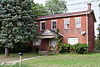 | April 15, 1996 (#96001211) | U.S. Route 40 0.5 miles (0.80 km) west of South Strabane 40°08′34″N 80°10′26″W / 40.142778°N 80.173889°W / 40.142778; -80.173889 (Doak-Little House) | South Strabane Township | |
| 24 | Joseph Dorsey House |  | November 19, 1974 (#74001814) | 113 Cherry Avenue, west of West Brownsville 40°01′14″N 79°55′24″W / 40.020556°N 79.923333°W / 40.020556; -79.923333 (Joseph Dorsey House) | Centerville | |
| 25 | Dusmal House |  | February 24, 1975 (#75001675) | East of Gastonville off Gilmore Road 40°15′10″N 79°57′55″W / 40.252778°N 79.965278°W / 40.252778; -79.965278 (Dusmal House) | Union Township | |
| 26 | East Washington Historic District |  | November 15, 1984 (#84000547) | Roughly bounded by North, East, and Wade Avenues and Wheeling, Beau, and Chestnut Streets 40°10′18″N 80°14′04″W / 40.171667°N 80.234444°W / 40.171667; -80.234444 (East Washington Historic District) | East Washington | |
| 27 | Ebenezer Covered Bridge |  | June 22, 1979 (#79003829) | Mingo Creek County Park spanning Mingo Creek[5] 40°11′28″N 80°02′28″W / 40.1911°N 80.0411°W / 40.1911; -80.0411 (Ebenezer Covered Bridge) | Nottingham Township | Moved from original location spanning South Fork Maple Creek at Ginger Hill in 1977[5] |
| 28 | Erskine Covered Bridge | 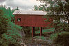 | June 22, 1979 (#79002359) | Erskine Road spanning Middle Wheeling Creek, south of West Alexander[5] 40°03′59″N 80°30′59″W / 40.0664°N 80.5164°W / 40.0664; -80.5164 (Erskine Covered Bridge) | West Finley Township | |
| 29 | First National Bank of Charleroi |  | February 7, 2007 (#07000032) | 210 Fifth Street 40°08′25″N 79°53′52″W / 40.140278°N 79.897778°W / 40.140278; -79.897778 (First National Bank of Charleroi) | Charleroi | |
| 30 | Molly Fleming House |  | May 30, 1997 (#97000519) | 616 Wood Street 40°03′48″N 79°53′28″W / 40.063333°N 79.891042°W / 40.063333; -79.891042 (Molly Fleming House) | California | |
| 31 | Philip Friend House |  | November 12, 1998 (#98001371) | 105 Little Daniels Run Road 40°04′14″N 80°07′31″W / 40.070556°N 80.125278°W / 40.070556; -80.125278 (Philip Friend House) | North Bethlehem Township | |
| 32 | Harrison House |  | December 30, 1974 (#74001807) | Old Route 40 40°02′19″N 79°57′12″W / 40.038611°N 79.953333°W / 40.038611; -79.953333 (Harrison House) | Centerville | The house no longer exists |
| 33 | Hawthorne School | 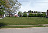 | May 8, 1986 (#86001028) | Hawthorne and Bluff Streets 40°15′38″N 80°11′47″W / 40.260453°N 80.196389°W / 40.260453; -80.196389 (Hawthorne School) | Canonsburg | |
| 34 | Henry Covered Bridge |  | June 22, 1979 (#79002353) | Mansion Hill Road spanning Mingo Creek, west of Monongahela[5] 40°12′08″N 80°01′01″W / 40.2022°N 80.0169°W / 40.2022; -80.0169 (Henry Covered Bridge) | Nottingham Township | |
| 35 | Hill's Tavern | 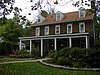 | November 19, 1974 (#74001811) | U.S. Route 40 in Scenery Hill 40°05′08″N 80°04′11″W / 40.085556°N 80.069722°W / 40.085556; -80.069722 (Hill's Tavern) | North Bethlehem Township | Heavily damaged by fire on August 17–18, 2015, interior gutted.[6] |
| 36 | Huffman Distillery and Chopping Mill |  | November 12, 1992 (#92001499) | Caldwell Road, 2 miles (3.2 km) north of the junction with Pennsylvania Route 917, north of Cokeburg 40°07′21″N 80°03′59″W / 40.1225°N 80.066389°W / 40.1225; -80.066389 (Huffman Distillery and Chopping Mill) | Somerset Township | |
| 37 | Hughes Covered Bridge |  | June 22, 1979 (#79002357) | Spans Ten Mile Creek, southeast of Prosperity 40°01′59″N 80°09′37″W / 40.033056°N 80.160278°W / 40.033056; -80.160278 (Hughes Covered Bridge) | Amwell Township | |
| 38 | Jackson's Mill Covered Bridge |  | June 22, 1979 (#79003830) | Kings Creek Road spanning Kings Creek, northwest of Burgettstown[5] 40°25′26″N 80°29′21″W / 40.4239°N 80.4892°W / 40.4239; -80.4892 (Jackson's Mill Covered Bridge) | Hanover Township | |
| 39 | Jennings-Gallagher House |  | March 28, 1996 (#96000318) | 429 Wood Street 40°03′52″N 79°53′26″W / 40.064444°N 79.890556°W / 40.064444; -79.890556 (Jennings-Gallagher House) | California | |
| 40 | Kinder's Mill |  | October 16, 1986 (#86002888) | State Route 2011 at Piper Road 40°01′51″N 80°03′18″W / 40.030833°N 80.055°W / 40.030833; -80.055 (Kinder's Mill) | Deemston | |
| 41 | Krepps Covered Bridge |  | June 22, 1979 (#79002352) | Covered Bridge Road, southeast of Cherry Valley and southwest of Midway[5] 40°20′26″N 80°19′53″W / 40.3406°N 80.3314°W / 40.3406; -80.3314 (Krepps Covered Bridge) | Mount Pleasant Township | |
| 42 | Leatherman Covered Bridge |  | June 22, 1979 (#79002351) | Leatherman Bridge Road, north of Cokeburg 40°06′33″N 80°04′18″W / 40.109236°N 80.071667°W / 40.109236; -80.071667 (Leatherman Covered Bridge) | North Bethlehem Township | |
| 43 | LeMoyne Crematory |  | February 16, 1996 (#96000078) | Northwestern corner of the junction of Redstone Road and Elm Street, southeast of Washington 40°09′38″N 80°14′16″W / 40.160556°N 80.237778°W / 40.160556; -80.237778 (LeMoyne Crematory) | North Franklin Township | |
| 44 | F. Julius LeMoyne House |  | September 25, 1997 (#97001271) | 49 East Maiden Street 40°10′05″N 80°14′36″W / 40.168056°N 80.243333°W / 40.168056; -80.243333 (F. Julius LeMoyne House) | Washington | |
| 45 | Moses Little Tavern |  | February 16, 1996 (#96000088) | 438 East National Pike, southeast of Laboratory 40°08′58″N 80°11′19″W / 40.149444°N 80.188611°W / 40.149444; -80.188611 (Moses Little Tavern) | Amwell Township | |
| 46 | David Longwell House |  | August 2, 1993 (#93000718) | 711 West Main Street 40°12′19″N 79°55′53″W / 40.205278°N 79.931389°W / 40.205278; -79.931389 (David Longwell House) | Monongahela | |
| 47 | Lyle Covered Bridge |  | June 22, 1979 (#79003831) | Kramer Road spanning Brush Run, north of Raccoon 40°27′15″N 80°22′32″W / 40.454239°N 80.375514°W / 40.454239; -80.375514 (Lyle Covered Bridge) | Hanover Township | |
| 48 | Malden Inn |  | January 24, 1974 (#74001805) | West of Blainsburg on U.S. Route 40 40°02′15″N 79°55′50″W / 40.0375°N 79.930556°W / 40.0375; -79.930556 (Malden Inn) | California | |
| 49 | Marianna Historic District |  | November 15, 1984 (#84000560) | Roughly bounded by Ten Mile Creek, Beeson Avenue Hill, and 6th and 7th Streets 40°01′21″N 80°05′53″W / 40.0225°N 80.098056°W / 40.0225; -80.098056 (Marianna Historic District) | Marianna | |
| 50 | Martin Farmstead |  | July 21, 1995 (#95000886) | Pennsylvania Route 136, 2 miles (3.2 km) west of Eighty-Four 40°11′01″N 80°10′06″W / 40.183611°N 80.168333°W / 40.183611; -80.168333 (Martin Farmstead) | South Strabane Township | |
| 51 | Martin's Mill Covered Bridge |  | June 22, 1979 (#79003825) | West of Marianna crossing Ten Mile Creek 40°00′49″N 80°07′54″W / 40.013611°N 80.131667°W / 40.013611; -80.131667 (Martin's Mill Covered Bridge) | Amwell and West Bethlehem Townships | The bridge no longer exists. |
| 52 | Dr. Joseph Maurer House |  | December 30, 1993 (#93001470) | 97 West Wheeling Street 40°10′09″N 80°14′51″W / 40.169086°N 80.247461°W / 40.169086; -80.247461 (Dr. Joseph Maurer House) | Washington | |
| 53 | Blaney Mays Covered Bridge |  | June 22, 1979 (#79002350) | Waynesburg Road spanning Middle Wheeling Creek, southwest of Claysville[5] 40°05′17″N 80°29′15″W / 40.0881°N 80.4875°W / 40.0881; -80.4875 (Blaney Mays Covered Bridge) | Donegal Township | |
| 54 | Meadowcroft Rockshelter |  | November 21, 1978 (#78002480) | West of Avella 40°17′11″N 80°29′30″W / 40.286389°N 80.491667°W / 40.286389; -80.491667 (Meadowcroft Rockshelter) | Jefferson Township | |
| 55 | Longdon L. Miller Covered Bridge |  | June 22, 1979 (#79002363) | Miller Creek Road spanning Templeton Fork Wheeling Creek, west of Enon[5] 39°58′41″N 80°26′47″W / 39.9781°N 80.4464°W / 39.9781; -80.4464 (Longdon L. Miller Covered Bridge) | West Finley Township | |
| 56 | Mingo Creek Presbyterian Church and Churchyard |  | November 12, 1992 (#92001500) | Junction of Pennsylvania Route 88 and Mingo Church Road, northwest of Courtney 40°13′44″N 79°59′50″W / 40.228889°N 79.997222°W / 40.228889; -79.997222 (Mingo Creek Presbyterian Church and Churchyard) | Union Township | |
| 57 | Monongahela Cemetery |  | October 14, 2001 (#01001116) | Cemetery Hill Road at Gregg Street 40°11′39″N 79°55′20″W / 40.194167°N 79.922222°W / 40.194167; -79.922222 (Monongahela Cemetery) | Monongahela | |
| 58 | Montgomery House | 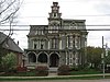 | October 25, 1974 (#74001809) | West Main Street 40°06′57″N 80°24′58″W / 40.115833°N 80.416111°W / 40.115833; -80.416111 (Montgomery House) | Claysville | |
| 59 | Thomas Munce House |  | June 28, 1996 (#96000710) | Pennsylvania Route 136, 3 miles (4.8 km) east of Washington 40°11′13″N 80°10′48″W / 40.186944°N 80.18°W / 40.186944; -80.18 (Thomas Munce House) | South Strabane Township | |
| 60 | John H. Nelson House |  | May 5, 2000 (#00000452) | 104 Colvin Road 40°08′04″N 79°57′28″W / 40.134444°N 79.957778°W / 40.134444; -79.957778 (John H. Nelson House) | Fallowfield Township | |
| 61 | Nesbit-Walker Farm |  | February 2, 2016 (#15001033) | 173 Mulberry Hill 40°14′26″N 80°18′08″W / 40.240556°N 80.302222°W / 40.240556; -80.302222 (Nesbit-Walker Farm) | Canton Township | |
| 62 | Old Main, California State College | 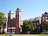 | May 2, 1974 (#74001806) | California University of Pennsylvania campus 40°03′57″N 79°53′08″W / 40.065833°N 79.885556°W / 40.065833; -79.885556 (Old Main, California State College) | California | |
| 63 | Robert Parkinson Farm |  | July 15, 2002 (#01000603) | Pennsylvania Route 18, 0.4 miles (0.64 km) north of Old Concord 40°00′44″N 80°20′00″W / 40.012222°N 80.333333°W / 40.012222; -80.333333 (Robert Parkinson Farm) | Morris Township | |
| 64 | Pennsylvania Railroad Freight Station | 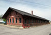 | July 21, 1995 (#95000891) | 111 Washington Street 40°10′20″N 80°15′15″W / 40.172222°N 80.254167°W / 40.172222; -80.254167 (Pennsylvania Railroad Freight Station) | Washington | |
| 65 | Pennsylvania Railroad Passenger Station | 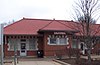 | June 19, 1979 (#79002349) | 100 Wood Street 40°04′05″N 79°53′21″W / 40.068056°N 79.889167°W / 40.068056; -79.889167 (Pennsylvania Railroad Passenger Station) | California | |
| 66 | Pine Bank Covered Bridge |  | June 22, 1979 (#79003824) | Meadowcroft Rockshelter and Museum of Rural Life, southwest of Studa crossing a ravine[5] 40°17′20″N 80°29′27″W / 40.2889°N 80.4908°W / 40.2889; -80.4908 (Pine Bank Covered Bridge) | Jefferson Township | |
| 67 | Plant's Covered Bridge |  | June 22, 1979 (#79002364) | Skyview Road spanning Templeton Fork Wheeling Creek[5] 40°01′16″N 80°24′58″W / 40.0211°N 80.4161°W / 40.0211; -80.4161 (Plant's Covered Bridge) | East Finley Township | |
| 68 | Plantation Plenty |  | June 21, 1975 (#75001673) | 2 miles (3.2 km) south of Avella on Pennsylvania Route 231 40°15′17″N 80°27′40″W / 40.254722°N 80.461111°W / 40.254722; -80.461111 (Plantation Plenty) | Independence Township | Boundary increase and renaming, February 2, 2016. |
| 69 | Ralston Freeman Covered Bridge | 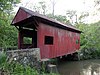 | June 22, 1979 (#79003827) | North of Paris crossing Aunt Clara's Fork of King's Creek 40°26′49″N 80°30′26″W / 40.446997°N 80.507122°W / 40.446997; -80.507122 (Ralston Freeman Covered Bridge) | Hanover Township | |
| 70 | Regester Log House |  | October 16, 1974 (#74001810) | North of Fredericktown off Pennsylvania Route 88 40°00′42″N 79°59′45″W / 40.011797°N 79.995819°W / 40.011797; -79.995819 (Regester Log House) | East Bethlehem Township | |
| 71 | Ringland Tavern |  | February 16, 1996 (#96000091) | U.S. Route 40 in Scenery Hill 40°05′03″N 80°04′06″W / 40.084167°N 80.068333°W / 40.084167; -80.068333 (Ringland Tavern) | North Bethlehem Township | |
| 72 | Roberts House |  | April 10, 1975 (#75001674) | 225 North Central Avenue 40°15′40″N 80°11′15″W / 40.261139°N 80.187453°W / 40.261139; -80.187453 (Roberts House) | Canonsburg | |
| 73 | Frank L. Ross Farm | 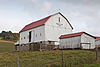 | March 20, 2002 (#02000226) | Pennsylvania Route 519, 0.3 miles (0.48 km) north of U.S. Route 40 40°07′56″N 80°08′01″W / 40.132222°N 80.133611°W / 40.132222; -80.133611 (Frank L. Ross Farm) | North Bethlehem and South Strabane Townships | |
| 74 | "S" Bridge | 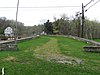 | April 4, 1975 (#75001676) | U.S. Route 40 at Pennsylvania Route 221, 6 miles (9.7 km) west of Washington 40°08′22″N 80°21′00″W / 40.139444°N 80.35°W / 40.139444; -80.35 ("S" Bridge) | Buffalo Township | |
| 75 | Sawhill Covered Bridge |  | June 22, 1979 (#79002358) | Off Pennsylvania Route 221, northwest of Taylorstown 40°10′48″N 80°24′59″W / 40.18°N 80.416389°W / 40.18; -80.416389 (Sawhill Covered Bridge) | Blaine Township | |
| 76 | Scenery Hill Historic District |  | October 24, 1996 (#96001198) | Roughly National Pike East/U.S. Route 40 between Scenery Hill Cemetery and Kinder Road in Scenery Hill 40°05′08″N 80°04′17″W / 40.085556°N 80.071389°W / 40.085556; -80.071389 (Scenery Hill Historic District) | North Bethlehem Township | |
| 77 | David Slusher Farm | 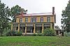 | February 2, 2016 (#15001035) | 546 Lone Pine Rd. 40°04′36″N 80°10′42″W / 40.076667°N 80.178333°W / 40.076667; -80.178333 (David Slusher Farm) | Amwell Township | |
| 78 | Sprowl's Covered Bridge |  | June 22, 1979 (#79002365) | Off Pennsylvania Route 231 40°00′39″N 80°24′25″W / 40.010833°N 80.406944°W / 40.010833; -80.406944 (Sprowl's Covered Bridge) | East Finley Township | |
| 79 | Stephenson-Campbell House |  | August 22, 2002 (#02000891) | At the end of Tomahawk Claim Lane, off Reissing Road 40°20′31″N 80°11′43″W / 40.3419°N 80.1953°W / 40.3419; -80.1953 (Stephenson-Campbell House) | Cecil Township | |
| 80 | Taylorstown Historic District |  | September 5, 1985 (#85001958) | Main Street in Taylorstown 40°09′35″N 80°22′45″W / 40.1597°N 80.3792°W / 40.1597; -80.3792 (Taylorstown Historic District) | Blaine Township | |
| 81 | James Thome Farm |  | April 11, 1997 (#97000292) | 213 Linnwood Road, northwest of Eighty Four 40°11′53″N 80°09′30″W / 40.1981°N 80.1583°W / 40.1981; -80.1583 (James Thome Farm) | North Strabane Township | |
| 82 | Trinity Hall |  | September 27, 1976 (#76001681) | 1 mile (1.6 km) south of Washington on Pennsylvania Route 18 40°09′53″N 80°14′56″W / 40.1647°N 80.2489°W / 40.1647; -80.2489 (Trinity Hall) | North Franklin Township | |
| 83 | Ulery Mill |  | April 20, 1978 (#78002481) | Southeast of Marianna 40°00′40″N 80°04′32″W / 40.0111°N 80.0756°W / 40.0111; -80.0756 (Ulery Mill) | West Bethlehem Township | Demolished |
| 84 | US Post Office-Charleroi |  | January 4, 1990 (#89002287) | 638 Fallowfield Avenue 40°08′24″N 79°54′02″W / 40.14°N 79.9006°W / 40.14; -79.9006 (US Post Office-Charleroi) | Charleroi | |
| 85 | Washington Armory |  | May 9, 1991 (#91000520) | 76 West Maiden Street 40°10′02″N 80°14′47″W / 40.1673°N 80.2465°W / 40.1673; -80.2465 (Washington Armory) | Washington | |
| 86 | Washington Commercial Historic District | Upload image | May 6, 2021 (#100005206) | Roughly bounded by Spruce Ave., Park Ave., Shaffer Ave., Bownson Ave., and Franklin St. 40°10′17″N 80°14′44″W / 40.1715°N 80.2456°W / 40.1715; -80.2456 (Washington Commercial Historic District) | Washington | |
| 87 | Washington County Courthouse |  | July 30, 1974 (#74001812) | South Main Street 40°10′14″N 80°14′45″W / 40.17045°N 80.2458°W / 40.17045; -80.2458 (Washington County Courthouse) | Washington | |
| 88 | Washington County Jail |  | July 30, 1974 (#74001813) | Cherry Street 40°10′13″N 80°14′47″W / 40.1702°N 80.2463°W / 40.1702; -80.2463 (Washington County Jail) | Washington | |
| 89 | Washington Trust Company Building |  | January 7, 2015 (#14001133) | 6 S. Main St. 40°10′15″N 80°14′43″W / 40.1708°N 80.2454°W / 40.1708; -80.2454 (Washington Trust Company Building) | Washington | |
| 90 | Webster Donora Bridge |  | June 22, 1988 (#88000813) | State Route 1022 over the Monongahela River 40°11′03″N 79°51′08″W / 40.1842°N 79.8522°W / 40.1842; -79.8522 (Webster Donora Bridge) | Donora | Extends into Rostraver Township in Westmoreland County |
| 91 | Welsh-Emery House |  | March 7, 1995 (#95000126) | 114 Emery Road 40°02′58″N 80°00′04″W / 40.0494°N 80.0011°W / 40.0494; -80.0011 (Welsh-Emery House) | Centerville | |
| 92 | West Alexander Historic District |  | March 7, 1985 (#85000471) | Roughly bounded by Main, North Liberty, and Mechanic Streets in West Alexander 40°06′15″N 80°30′37″W / 40.1042°N 80.5103°W / 40.1042; -80.5103 (West Alexander Historic District) | Donegal Township | |
| 93 | West Middletown Historic District |  | August 8, 1985 (#85001740) | Main Street 40°14′34″N 80°25′34″W / 40.2428°N 80.4261°W / 40.2428; -80.4261 (West Middletown Historic District) | West Middletown | |
| 94 | John White House |  | November 12, 1998 (#98001370) | 2151 North Main Street Extension 40°12′28″N 80°15′25″W / 40.2078°N 80.2569°W / 40.2078; -80.2569 (John White House) | Chartiers Township | |
| 95 | Wilson's Mill Covered Bridge |  | June 22, 1979 (#79003826) | Northeast of the junction of Pennsylvania Route 980 and Johns Avenue[5] 40°22′03″N 80°14′02″W / 40.3674°N 80.2339°W / 40.3674; -80.2339 (Wilson's Mill Covered Bridge) | McDonald | Has been moved from its earlier location on Oakleaf Road over Cross Creek, southeast of Avella[7] |
| 96 | Levi Wilson Tavern |  | April 15, 1996 (#96001210) | U.S. Route 40, 1.5 miles (2.4 km) east of the S Bridge 40°09′00″N 80°19′44″W / 40.15°N 80.3289°W / 40.15; -80.3289 (Levi Wilson Tavern) | Buffalo Township | |
| 97 | Cerl Wright Covered Bridge |  | June 22, 1979 (#79003832) | Ridge Road, northwest of Bentleyville crossing North Fork of Pigeon Creek 40°09′32″N 80°02′56″W / 40.1589°N 80.0489°W / 40.1589; -80.0489 (Cerl Wright Covered Bridge) | Somerset Township | |
| 98 | Enoch Wright House |  | May 24, 2007 (#07000466) | 815 Venetia Road 40°14′59″N 80°01′44″W / 40.2497°N 80.0289°W / 40.2497; -80.0289 (Enoch Wright House) | Peters Township | |
| 99 | Wyit Sprowls Covered Bridge |  | June 22, 1979 (#79002366) | East Finley Township park spanning Robinson Fork Wheeling Creek[5] 40°02′22″N 80°24′06″W / 40.0394°N 80.4017°W / 40.0394; -80.4017 (Wyit Sprowls Covered Bridge) | East Finley Township | Relocated to current location from West Finley Township approximately 1996[5] |
Former listing
| [3] | Name on the Register | Image | Date listed | Date removed | Location | City or town | Description |
|---|---|---|---|---|---|---|---|
| 1 | Sackville House |  | November 21, 1976 (#76001680) | August 24, 2010 | 309 East Wheeling Street 40°10′14″N 80°14′17″W / 40.170556°N 80.238056°W / 40.170556; -80.238056 (Sackville House) | East Washington | Demolished circa 1980 |
See also
Wikimedia Commons has media related to National Register of Historic Places in Washington County, Pennsylvania.
- List of Pennsylvania state historical markers in Washington County
- Washington County History & Landmarks Foundation
References
- ^ The latitude and longitude information provided in this table was derived originally from the National Register Information System, which has been found to be fairly accurate for about 99% of listings. Some locations in this table may have been corrected to current GPS standards.
- ^ National Park Service, United States Department of the Interior, "National Register of Historic Places: Weekly List Actions", retrieved April 12, 2024.
- ^ a b Numbers represent an alphabetical ordering by significant words. Various colorings, defined here, differentiate National Historic Landmarks and historic districts from other NRHP buildings, structures, sites or objects.
- ^ The eight-digit number below each date is the number assigned to each location in the National Register Information System database, which can be viewed by clicking the number.
- ^ a b c d e f g h i j k l m n o p q "Covered Bridges Driving Tour" (PDF). Washington County Tourism Promotion Agency. Archived from the original (PDF) on December 1, 2010. Retrieved March 23, 2010.
- ^ Templeton, David (August 18, 2015). "Fire destroys historic Century Inn in Washington County". Pittsburgh Post-Gazette. PG Publishing Co., Inc. Retrieved August 19, 2015.
- ^ "National Register Information System". National Register of Historic Places. National Park Service. July 9, 2010.
- v
- t
- e

- Adams
- Allegheny
- Armstrong
- Beaver
- Bedford
- Berks
- Blair
- Bradford
- Bucks
- Butler
- Cambria
- Cameron
- Carbon
- Centre
- Chester
- Clarion
- Clearfield
- Clinton
- Columbia
- Crawford
- Cumberland
- Dauphin
- Delaware
- Elk
- Erie
- Fayette
- Forest
- Franklin
- Fulton
- Greene
- Huntingdon
- Indiana
- Jefferson
- Juniata
- Lackawanna
- Lancaster
- Lawrence
- Lebanon
- Lehigh
- Luzerne
- Lycoming
- McKean
- Mercer
- Mifflin
- Monroe
- Montgomery
- Montour
- Northampton
- Northumberland
- Perry
- Philadelphia
- Pike
- Potter
- Schuylkill
- Snyder
- Somerset
- Sullivan
- Susquehanna
- Tioga
- Union
- Venango
- Warren
- Washington
- Wayne
- Westmoreland
- Wyoming
- York
 Category
 NRHP portal


