Grade II* listed buildings in Craven
Map all coordinates using OpenStreetMap
Download coordinates as:
- KML
- GPX (all coordinates)
- GPX (primary coordinates)
- GPX (secondary coordinates)
There are over 20,000 Grade II* listed buildings in England. This page is a list of these buildings in the district of Craven in North Yorkshire.
List of buildings
| Name | Location | Type | Completed [note 1] | Date designated | Grid ref.[note 2] Geo-coordinates | Entry number [note 3] | Image |
|---|---|---|---|---|---|---|---|
| Airton Quaker Meeting House, archway and bench | Airton | Friends Meeting House | 1694 | 20 February 1958 | SD9031359214 54°01′44″N 2°08′58″W / 54.02884°N 2.14947°W / 54.02884; -2.14947 (Airton Quaker Meeting House, archway and bench) | 1132105 | 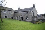 More images |
| Parcevall Hall | Skyreholme, Appletreewick | House | 16th century | 10 September 1954 | SE0689161249 54°02′50″N 1°53′46″W / 54.047163°N 1.896249°W / 54.047163; -1.896249 (Parcevall Hall) | 1157423 | 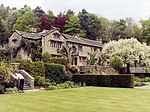 More images |
| Henry Simpson's Barn | Skyreholme, Appletreewick | Barn | 1737 | 26 October 1995 | SE0695161288 54°02′51″N 1°53′43″W / 54.047513°N 1.895332°W / 54.047513; -1.895332 (Henry Simpson's Barn) | 1249282 | 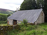 More images |
| High Hall | Appletreewick | House | 16th century | 10 September 1954 | SE0543860090 54°02′12″N 1°55′06″W / 54.036763°N 1.91846°W / 54.036763; -1.91846 (High Hall) | 1131792 |  More images |
| Barn to north-west of Newton Hall | Bank Newton | Cow house | Mid-17th century | 10 September 1954 | SD9090453146 53°58′27″N 2°08′25″W / 53.974299°N 2.140164°W / 53.974299; -2.140164 (Barn to north-west of Newton Hall) | 1167635 |  Upload Photo |
| Bank Newton Hall | Bank Newton | House | Mid-17th century | 10 September 1954 | SD9092453108 53°58′26″N 2°08′23″W / 53.973957°N 2.139858°W / 53.973957; -2.139858 (Bank Newton Hall) | 1316866 |  More images |
| Beamsley Hospital (south range) | Beamsley | Almshouse | 1593 | 10 September 1954 | SE0823953030 53°58′24″N 1°52′33″W / 53.973274°N 1.875881°W / 53.973274; -1.875881 (Beamsley Hospital (south range)) | 1166620 |  More images |
| Church of St John the Baptist | Low Bentham, Bentham | Church | 15th century | 20 February 1958 | SD6447369272 54°07′05″N 2°32′42″W / 54.118079°N 2.545007°W / 54.118079; -2.545007 (Church of St John the Baptist) | 1157613 |  More images |
| Mewith Head Hall, wall to garden and gatepiers | Bentham | House | Early 18th century | 20 February 1958 | SD6984166903 54°05′50″N 2°27′46″W / 54.097133°N 2.462651°W / 54.097133; -2.462651 (Mewith Head Hall, wall to garden and gatepiers) | 1132417 | 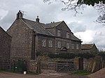 More images |
| Bolton Abbey Hall | Bolton Abbey | House | Mid-19th century | 10 September 1954 | SE0729254204 53°59′02″N 1°53′25″W / 53.98384°N 1.890291°W / 53.98384; -1.890291 (Bolton Abbey Hall) | 1131774 |  More images |
| The Great Tythe Barn | Bolton Abbey | Threshing barn | 16th century | 10 September 1954 | SE0725353838 53°58′50″N 1°53′27″W / 53.980551°N 1.890895°W / 53.980551; -1.890895 (The Great Tythe Barn) | 1131772 |  More images |
| The Old Rectory | Bolton Abbey | House | Late 17th century | 10 September 1954 | SE0738754140 53°59′00″N 1°53′20″W / 53.983263°N 1.888844°W / 53.983263; -1.888844 (The Old Rectory) | 1131776 |  More images |
| Church of St Michael and All Angels | Hubberholme, Buckden | Church | 12th century | 10 September 1954 | SD9261478268 54°12′00″N 2°06′53″W / 54.20011°N 2.114717°W / 54.20011; -2.114717 (Church of St Michael and All Angels) | 1167280 |  More images |
| Church of All Saints and churchyard wall and railings | Burton in Lonsdale | Church | 1868–76 | 24 June 1988 | SD6511272139 54°08′38″N 2°32′08″W / 54.143889°N 2.535564°W / 54.143889; -2.535564 (Church of All Saints and churchyard wall and railings) | 1132430 | 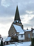 More images |
| Trappes Hall | Carleton | House | c.1686 | 10 September 1954 | SD9713049741 53°56′38″N 2°02′43″W / 53.943769°N 2.045211°W / 53.943769; -2.045211 (Trappes Hall) | 1166761 |  |
| Ingleborough Hall | Clapham cum Newby | Country house | c.1814 | 20 February 1958 | SD7468269343 54°07′10″N 2°23′20″W / 54.119324°N 2.388835°W / 54.119324; -2.388835 (Ingleborough Hall) | 1132400 | Upload Photo |
| Kilnsey Old Hall | Kilnsey, Conistone with Kilnsey | House | 1648 | 10 September 1954 | SD9732467845 54°06′23″N 2°02′33″W / 54.106482°N 2.042422°W / 54.106482; -2.042422 (Kilnsey Old Hall) | 1316821 |  More images |
| Carr Head Hall | Cowling | Country house | Mid-18th century | 10 September 1954 | SD9750044277 53°53′41″N 2°02′22″W / 53.894662°N 2.039527°W / 53.894662; -2.039527 (Carr Head Hall) | 1157455 |  More images |
| Long Croft and attached barn | Cowling | Farmhouse and barn | c.1700 | 23 October 1984 | SD9693643945 53°53′30″N 2°02′53″W / 53.891675°N 2.048106°W / 53.891675; -2.048106 (Long Croft and attached barn) | 1131807 | Upload Photo |
| Elslack Hall Farmhouse and Elslack Hall Cottage with garden wall adjoining to north | Elslack | Farmhouse | 1988 | 10 September 1954 | SD9285249225 53°56′21″N 2°06′37″W / 53.939089°N 2.110372°W / 53.939089; -2.110372 (Elslack Hall Farmhouse and Elslack Hall Cottage with garden wall adjoining to north) | 1166963 | 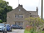 |
| Manor House | Embsay, Embsay with Eastby | House | c.1635 | 10 September 1954 | SE0054253830 53°58′50″N 1°59′36″W / 53.980528°N 1.993224°W / 53.980528; -1.993224 (Manor House) | 1157616 |  |
| Eshton Hall | Eshton | House | 1825–27 | 10 September 1954 | SD9377655994 54°00′00″N 2°05′47″W / 53.999939°N 2.096438°W / 53.999939; -2.096438 (Eshton Hall) | 1167726 |  More images |
| Brockabank | Flasby with Winterburn | Farmhouse | Late 16th century | 10 September 1954 | SD9344656886 54°00′29″N 2°06′05″W / 54.007951°N 2.101492°W / 54.007951; -2.101492 (Brockabank) | 1131652 |  |
| Friars Head | Flasby with Winterburn | House | c.1670 | 10 September 1954 | SD9320757533 54°00′50″N 2°06′19″W / 54.013763°N 2.105153°W / 54.013763; -2.105153 (Friars Head) | 1157656 |  More images |
| Beck House | Giggleswick | House | Early 18th century | 20 February 1958 | SD8104463991 54°04′17″N 2°17′28″W / 54.071498°N 2.291167°W / 54.071498; -2.291167 (Beck House) | 1317037 |  |
| Giggleswick School Chapel | Giggleswick | Chapel | 1897–1901 | 20 February 1958 | SD8072063927 54°04′15″N 2°17′46″W / 54.070911°N 2.296114°W / 54.070911; -2.296114 (Giggleswick School Chapel) | 1131724 |  More images |
| Ivy Fold | Giggleswick | House | Mid-17th century | 20 February 1958 | SD8110664071 54°04′20″N 2°17′25″W / 54.07222°N 2.290225°W / 54.07222; -2.290225 (Ivy Fold) | 1131721 | Upload Photo |
| Settle Bridge | Giggleswick | Road bridge | 17th century | 20 November 1987 | SD8165264094 54°04′21″N 2°16′55″W / 54.072446°N 2.281882°W / 54.072446; -2.281882 (Settle Bridge) | 1317032 | 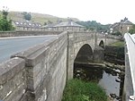 More images |
| Grassington Hall | Grassington | House | Medieval | 10 September 1954 | SE0020964058 54°04′21″N 1°59′54″W / 54.072453°N 1.998299°W / 54.072453; -1.998299 (Grassington Hall) | 1132153 | Upload Photo |
| Church of St. Peter | Hebden | Church | 1841 | 25 January 1994 | SE0260062967 54°03′45″N 1°57′42″W / 54.062615°N 1.961762°W / 54.062615; -1.961762 (Church of St. Peter) | 1203742 |  More images |
| Arnford Farmhouse | Hellifield | Farmhouse | c.1700 | 20 February 1958 | SD8364256279 54°03′45″N 2°15′04″W / 54.062615°N 2.251048°W / 54.062615; -2.251048 (Arnford Farmhouse) | 1317061 | Upload Photo |
| Lodge Hall | Horton in Ribblesdale | Farmhouse | 1687 | 20 February 1958 | SD7800277963 54°11′49″N 2°20′19″W / 54.196947°N 2.338676°W / 54.196947; -2.338676 (Lodge Hall) | 1289489 |  |
| Batty Moss Railway Viaduct (Ribblehead Viaduct) | Ingleton | Railway viaduct | 1870–74 | 23 November 1988 | SD7594479471 54°12′37″N 2°22′13″W / 54.210407°N 2.370341°W / 54.210407; -2.370341 (Batty Moss Railway Viaduct (Ribblehead Viaduct)) | 1132228 |  More images |
| Church of St Mary the Virgin | Ingleton | Church | 15th century | 20 February 1958 | SD6951273260 54°09′15″N 2°28′06″W / 54.154245°N 2.468325°W / 54.154245; -2.468325 (Church of St Mary the Virgin) | 1252726 |  More images |
| Chapel at Scargill House, including linking passage, staircase and vestry | Kettlewell with Starbotton | Steps | 1958–61 | 25 September 1998 | SD9779971067 54°08′08″N 2°02′07″W / 54.135442°N 2.035181°W / 54.135442; -2.035181 (Chapel at Scargill House, including linking passage, staircase and vestry) | 1376604 |  More images |
| Church of St Mary | Kettlewell | Church | 1820 | 10 September 1954 | SD9714072255 54°08′46″N 2°02′43″W / 54.146115°N 2.045279°W / 54.146115; -2.045279 (Church of St Mary) | 1173574 |  More images |
| Fold Farmhouse | Kettlewell | Farmhouse | Late 15th century | 4 May 1989 | SD9719872248 54°08′46″N 2°02′40″W / 54.146053°N 2.044391°W / 54.146053; -2.044391 (Fold Farmhouse) | 1173639 | Upload Photo |
| Kildwick Hall with kitchen block to rear | Kildwick | Kitchen | 1673 | 10 September 1954 | SE0117446307 53°54′46″N 1°59′01″W / 53.912912°N 1.983614°W / 53.912912; -1.983614 (Kildwick Hall with kitchen block to rear) | 1132170 |  More images |
| Church of St Michael and All Angels | Linton | Church | 12th century | 10 September 1954 | SE0050863229 54°03′54″N 1°59′37″W / 54.065003°N 1.993731°W / 54.065003; -1.993731 (Church of St Michael and All Angels) | 1167172 | 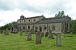 More images |
| Fountaines Hospital | Linton | Almshouse | 1721 | 10 September 1954 | SD9970962683 54°03′36″N 2°00′21″W / 54.060095°N 2.005938°W / 54.060095; -2.005938 (Fountaines Hospital) | 1132124 | 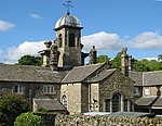 More images |
| Stone Gappe | Lothersdale | House | 1725 | 10 September 1954 | SD9679245751 53°54′28″N 2°03′01″W / 53.907906°N 2.050317°W / 53.907906; -2.050317 (Stone Gappe) | 1167086 | 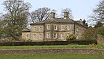 More images |
| Church of St Peter | Martons Both | Parish church | 12th century | 10 September 1954 | SD9080750690 53°57′08″N 2°08′30″W / 53.952223°N 2.141568°W / 53.952223; -2.141568 (Church of St Peter) | 1167226 |  More images |
| Gledstone Hall and forecourt walls, pavilions and gates | Martons Both | Apartments | 1922–26 | 31 October 1988 | SD8868551277 53°57′27″N 2°10′26″W / 53.957456°N 2.173925°W / 53.957456; -2.173925 (Gledstone Hall and forecourt walls, pavilions and gates) | 1296985 |  More images |
| Terraces at Gledstone Hall | Martons Both | Garden wall | 1923 | 31 October 1988 | SD8870351203 53°57′24″N 2°10′25″W / 53.956792°N 2.173647°W / 53.956792; -2.173647 (Terraces at Gledstone Hall) | 1316750 | Upload Photo |
| Ingthorpe Grange | Martons Both | House | 1672 | 10 September 1954 | SD8926552024 53°57′51″N 2°09′54″W / 53.964183°N 2.165112°W / 53.964183; -2.165112 (Ingthorpe Grange) | 1296906 |  More images |
| Old Gledstone | Martons Both | House | c.1770 | 10 September 1954 | SD8831350770 53°57′10″N 2°10′46″W / 53.952891°N 2.179574°W / 53.952891; -2.179574 (Old Gledstone) | 1132251 | Upload Photo |
| Friends Meeting House | Settle | Friends meeting house | 1678 | 13 September 1988 | SD8181963663 54°04′07″N 2°16′45″W / 54.068579°N 2.279304°W / 54.068579; -2.279304 (Friends Meeting House) | 1166732 |  More images |
| Settle Bridge | Bridge End, Settle | Road bridge | 17th century | 20 February 1958 | SD8165464091 54°04′21″N 2°16′55″W / 54.072419°N 2.281851°W / 54.072419; -2.281851 (Settle Bridge) | 1316710 |  More images |
| Christ Church | Skipton | Church | 1837–39 | 2 March 1978 | SD9882451338 53°57′29″N 2°01′10″W / 53.958129°N 2.01941°W / 53.958129; -2.01941 (Christ Church) | 1131846 |  More images |
| Devonshire Hotel | Skipton | Hotel | 18th century | 28 April 1952 | SD9907351571 53°57′37″N 2°00′56″W / 53.960224°N 2.015616°W / 53.960224; -2.015616 (Devonshire Hotel) | 1157440 |  More images |
| Swinden Hall | Swinden | Farmhouse | c.1600 | 20 February 1958 | SD8610754417 53°59′08″N 2°12′48″W / 53.985614°N 2.213356°W / 53.985614; -2.213356 (Swinden Hall) | 1296668 |  More images |
| Church of St Oswald | Thornton in Lonsdale | Church | 15th century | 20 February 1958 | SD6857173618 54°09′27″N 2°28′58″W / 54.157405°N 2.482771°W / 54.157405; -2.482771 (Church of St Oswald) | 1252730 |  More images |
See also
- Grade II* listed buildings in North Yorkshire
- Grade II* listed buildings in Selby (district)
- Grade II* listed buildings in Harrogate (borough)
- Grade II* listed buildings in Richmondshire
- Grade II* listed buildings in Hambleton
- Grade II* listed buildings in Ryedale
- Grade II* listed buildings in Scarborough (borough)
- Grade II* listed buildings in City of York
- Grade II* listed buildings in Redcar and Cleveland
- Grade II* listed buildings in Middlesbrough (borough)
- Grade I listed buildings in Craven
Notes
- ^ The date given is the date used by Historic England as significant for the initial building or that of an important part in the structure's description.
- ^ Sometimes known as OSGB36, the grid reference is based on the British national grid reference system used by the Ordnance Survey.
- ^ The "List Entry Number" is a unique number assigned to each listed building and scheduled monument by Historic England.
External links
![]() Media related to Grade II* listed buildings in Craven District at Wikimedia Commons
Media related to Grade II* listed buildings in Craven District at Wikimedia Commons
- v
- t
- e
- Bedfordshire
- Berkshire
- Bristol
- Buckinghamshire
- Cambridgeshire
- Cheshire
- Cornwall
- Cumbria
- Derbyshire
- Devon
- Dorset
- Durham
- East Sussex
- East Riding of Yorkshire
- Essex
- Gloucestershire
- Greater London
- Greater Manchester
- Hampshire
- Herefordshire
- Hertfordshire
- Isle of Wight
- Kent
- Lancashire
- Leicestershire
- Lincolnshire
- Merseyside
- Norfolk
- North Yorkshire
- Northamptonshire
- Northumberland
- Nottinghamshire
- Oxfordshire
- Rutland
- Shropshire
- Somerset
- South Yorkshire
- Staffordshire
- Suffolk
- Surrey
- Tyne and Wear
- Warwickshire
- West Midlands
- West Sussex
- West Yorkshire
- Wiltshire
- Worcestershire
- Allerdale
- Amber Valley
- Ashford
- Babergh
- Barrow-in-Furness
- Basildon
- Basingstoke and Deane
- Bath and North East Somerset
- Bolsover
- Boston
- Bournemouth
- Bradford
- Braintree
- Breckland
- Brentwood
- Brighton and Hove
- Bristol
- Broadland
- Calderdale
- Cambridge
- Camden
- Canterbury
- Carlisle
- Castle Point
- Chelmsford
- Cheltenham
- Cherwell
- Cheshire East
- Cheshire West and Chester
- Chesterfield
- Chiltern
- Christchurch
- Colchester
- Copeland
- Corby
- Cotswold
- Craven
- Dartford
- Daventry
- Dover
- East Cambridgeshire
- Exeter
- Mendip
- North Somerset
- Poole
- Sedgemoor
- South Somerset
- Stoke-on-Trent
- Taunton Deane
- West Somerset
- York


