List of listed buildings in Linton, Scottish Borders
This is a list of listed buildings in the parish of Linton in the Scottish Borders, Scotland.
Map all coordinates using OpenStreetMap
Download coordinates as:
- KML
- GPX (all coordinates)
- GPX (primary coordinates)
- GPX (secondary coordinates)
List
| Name | Location | Date Listed | Grid Ref. [note 1] | Geo-coordinates | Notes | LB Number [note 2] | Image |
|---|---|---|---|---|---|---|---|
| Clifton Park, Stables And Coach House Including Setted Courtyard | 55°31′57″N 2°22′29″W / 55.532429°N 2.374828°W / 55.532429; -2.374828 (Clifton Park, Stables And Coach House Including Setted Courtyard) | Category C(S) | 44973 |  Upload Photo | |||
| Carlops, Lynburn Including Garden Grotto And Linburn Cottage | 55°47′15″N 3°20′23″W / 55.787476°N 3.33971°W / 55.787476; -3.33971 (Carlops, Lynburn Including Garden Grotto And Linburn Cottage) | Category B | 8384 | Upload Photo | |||
| Carlops, Row Of 6 Cottages (Ferndale, Houlet, Amulree, Finlaggan, Blinkieknowe, Birkenbush) | 55°47′21″N 3°20′23″W / 55.789273°N 3.339676°W / 55.789273; -3.339676 (Carlops, Row Of 6 Cottages (Ferndale, Houlet, Amulree, Finlaggan, Blinkieknowe, Birkenbush)) | Category B | 8386 | Upload Photo | |||
| Carlops, Row Of 4 Cottages (Springbank, Carberry, Langskaill, Jess) | 55°47′26″N 3°20′22″W / 55.790651°N 3.339436°W / 55.790651; -3.339436 (Carlops, Row Of 4 Cottages (Springbank, Carberry, Langskaill, Jess)) | Category C(S) | 8390 | Upload Photo | |||
| Carlops, Mill Lane, Bridge Over River Esk At Patie's Mill | 55°47′30″N 3°20′20″W / 55.79162°N 3.338767°W / 55.79162; -3.338767 (Carlops, Mill Lane, Bridge Over River Esk At Patie's Mill) | Category C(S) | 8364 | Upload Photo | |||
| West Linton, The Loan, Srongarbh Including Railings, Boundary Walls, Garages, Garden Terraces And Steps, Swimming Pool, Pavilion And Other Ancillary Structures | 55°45′25″N 3°21′51″W / 55.756835°N 3.364107°W / 55.756835; -3.364107 (West Linton, The Loan, Srongarbh Including Railings, Boundary Walls, Garages, Garden Terraces And Steps, Swimming Pool, Pavilion And Other Ancillary Structures) | Category A | 51069 |  Upload another image | |||
| Carlops, Carlops Parish Church | 55°47′21″N 3°20′23″W / 55.789174°N 3.339688°W / 55.789174; -3.339688 (Carlops, Carlops Parish Church) | Category C(S) | 51627 | Upload Photo | |||
| Linton Church, Stables And Outbuildings | 55°31′47″N 2°21′41″W / 55.529675°N 2.361368°W / 55.529675; -2.361368 (Linton Church, Stables And Outbuildings) | Category C(S) | 44978 | Upload Photo | |||
| Old Graden Mansion House Including Outbuilding, Summerhouse, Boundary Walls, Gatepiers And Gates | 55°33′45″N 2°19′22″W / 55.5624°N 2.322792°W / 55.5624; -2.322792 (Old Graden Mansion House Including Outbuilding, Summerhouse, Boundary Walls, Gatepiers And Gates) | Category C(S) | 44980 | Upload Photo | |||
| Carlops, Allan Ramsay Hotel | 55°47′26″N 3°20′24″W / 55.790491°N 3.340037°W / 55.790491; -3.340037 (Carlops, Allan Ramsay Hotel) | Category B | 13687 | Upload Photo | |||
| Carlops, Row Of 3 Cottages (Ashley, The Biggin, Weavers) | 55°47′23″N 3°20′22″W / 55.789689°N 3.339435°W / 55.789689; -3.339435 (Carlops, Row Of 3 Cottages (Ashley, The Biggin, Weavers)) | Category B | 8387 | Upload Photo | |||
| Paulswell Farmhouse And Steading | 55°43′47″N 3°20′24″W / 55.729855°N 3.339949°W / 55.729855; -3.339949 (Paulswell Farmhouse And Steading) | Category C(S) | 8334 | Upload Photo | |||
| Spitalhaugh House Including Stable And Bridge | 55°43′59″N 3°20′06″W / 55.733091°N 3.334916°W / 55.733091; -3.334916 (Spitalhaugh House Including Stable And Bridge) | Category A | 8361 | Upload Photo | |||
| Carlops, Vallence Cottage | 55°47′29″N 3°20′20″W / 55.79125°N 3.338882°W / 55.79125; -3.338882 (Carlops, Vallence Cottage) | Category C(S) | 8362 | Upload Photo | |||
| Medwynhead House | 55°44′54″N 3°26′55″W / 55.748229°N 3.448676°W / 55.748229; -3.448676 (Medwynhead House) | Category C(S) | 8366 | Upload Photo | |||
| Hoselaw Chapel (Church Of Scotland) Including Boundary Walls And Gate | 55°34′45″N 2°18′58″W / 55.579067°N 2.316125°W / 55.579067; -2.316125 (Hoselaw Chapel (Church Of Scotland) Including Boundary Walls And Gate) | Category A | 18799 | 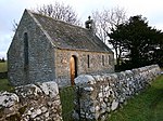 Upload another image | |||
| West Linton, Main Street, Gifford Stones House | 55°45′08″N 3°21′21″W / 55.752201°N 3.355772°W / 55.752201; -3.355772 (West Linton, Main Street, Gifford Stones House) | Category A | 12888 | Upload Photo | |||
| Carlops, Pentlands And Elphinstone | 55°47′24″N 3°20′24″W / 55.789891°N 3.339936°W / 55.789891; -3.339936 (Carlops, Pentlands And Elphinstone) | Category C(S) | 8388 | Upload Photo | |||
| West Linton, Bogsbank Road, Greenfield (Former St Andrew's Manse) | 55°44′57″N 3°21′26″W / 55.749128°N 3.357322°W / 55.749128; -3.357322 (West Linton, Bogsbank Road, Greenfield (Former St Andrew's Manse)) | Category B | 8353 | Upload Photo | |||
| West Linton, War Memorial | 55°45′01″N 3°21′23″W / 55.750155°N 3.356258°W / 55.750155; -3.356258 (West Linton, War Memorial) | Category C(S) | 8356 | Upload Photo | |||
| West Linton, Old Manor House | 55°45′13″N 3°21′22″W / 55.753717°N 3.356°W / 55.753717; -3.356 (West Linton, Old Manor House) | Category C(S) | 8358 |  Upload another image | |||
| Medwyn House | 55°45′22″N 3°22′06″W / 55.756042°N 3.368382°W / 55.756042; -3.368382 (Medwyn House) | Category B | 8360 | Upload Photo | |||
| Spitalhaugh, Doocot House | 55°44′00″N 3°20′09″W / 55.733358°N 3.33596°W / 55.733358; -3.33596 (Spitalhaugh, Doocot House) | Category C(S) | 51628 | Upload Photo | |||
| Deepsykehead Farmhouse And Stable Offices | 55°46′41″N 3°19′11″W / 55.778139°N 3.319842°W / 55.778139; -3.319842 (Deepsykehead Farmhouse And Stable Offices) | Category C(S) | 13684 | Upload Photo | |||
| West Linton, St Andrew's Parish Church Including Burial Ground, Gatepiers And Boundary Walls | 55°45′03″N 3°21′22″W / 55.750704°N 3.35623°W / 55.750704; -3.35623 (West Linton, St Andrew's Parish Church Including Burial Ground, Gatepiers And Boundary Walls) | Category B | 12889 |  Upload another image | |||
| Carlops, Carlops Mains Including Barn | 55°47′20″N 3°20′18″W / 55.788767°N 3.338335°W / 55.788767; -3.338335 (Carlops, Carlops Mains Including Barn) | Category B | 8383 | Upload Photo | |||
| Carlops, Drinking Fountain | 55°47′28″N 3°20′22″W / 55.790992°N 3.339432°W / 55.790992; -3.339432 (Carlops, Drinking Fountain) | Category B | 8389 | Upload Photo | |||
| West Linton, Clock Tower And Public Bell | 55°45′06″N 3°21′21″W / 55.751768°N 3.355852°W / 55.751768; -3.355852 (West Linton, Clock Tower And Public Bell) | Category B | 8359 |  Upload another image | |||
| Kitley Brig, Lodge And Gatepiers | 55°47′24″N 3°19′29″W / 55.789894°N 3.324705°W / 55.789894; -3.324705 (Kitley Brig, Lodge And Gatepiers) | Category B | 8365 | Upload Photo | |||
| Clifton Park, Clifton Lodge Including Entrance Walls, Piers, Gatepiers And Boundary Wall | 55°32′03″N 2°22′00″W / 55.534197°N 2.366606°W / 55.534197; -2.366606 (Clifton Park, Clifton Lodge Including Entrance Walls, Piers, Gatepiers And Boundary Wall) | Category C(S) | 44971 | Upload Photo | |||
| Clifton Park, Ice House | 55°31′58″N 2°22′20″W / 55.532877°N 2.372171°W / 55.532877; -2.372171 (Clifton Park, Ice House) | Category C(S) | 44972 | Upload Photo | |||
| Clifton Park, Walled Garden Including Shed | 55°31′52″N 2°22′32″W / 55.531097°N 2.375496°W / 55.531097; -2.375496 (Clifton Park, Walled Garden Including Shed) | Category C(S) | 44974 | Upload Photo | |||
| Frogden Farmhouse Including Outbuilding, Summerhouse, Sundial, Boundary Walls And Gatepiers | 55°32′47″N 2°22′36″W / 55.546395°N 2.376768°W / 55.546395; -2.376768 (Frogden Farmhouse Including Outbuilding, Summerhouse, Sundial, Boundary Walls And Gatepiers) | Category C(S) | 44975 | Upload Photo | |||
| Graden Farm, Cartshed And Granary | 55°34′14″N 2°19′25″W / 55.570421°N 2.323699°W / 55.570421; -2.323699 (Graden Farm, Cartshed And Granary) | Category B | 44976 | Upload Photo | |||
| Lindenlea, Carlops | 55°47′16″N 3°20′23″W / 55.787719°N 3.339638°W / 55.787719; -3.339638 (Lindenlea, Carlops) | Category B | 8385 | Upload Photo | |||
| Garvald Home Farm, Courtyard Range Including Farmhouse And Separate Barn | 55°43′42″N 3°26′15″W / 55.728438°N 3.437528°W / 55.728438; -3.437528 (Garvald Home Farm, Courtyard Range Including Farmhouse And Separate Barn) | Category B | 8382 | Upload Photo | |||
| West Linton, Carlops Road, Lynehurst | 55°45′07″N 3°21′33″W / 55.752021°N 3.359048°W / 55.752021; -3.359048 (West Linton, Carlops Road, Lynehurst) | Category C(S) | 51631 | Upload Photo | |||
| Linton Manse Cottage | 55°31′48″N 2°21′30″W / 55.530007°N 2.358393°W / 55.530007; -2.358393 (Linton Manse Cottage) | Category C(S) | 44979 | Upload Photo | |||
| West Linton, Chapel Brae, The Rectory (Former St Mungo's Manse) | 55°45′06″N 3°21′33″W / 55.751706°N 3.359069°W / 55.751706; -3.359069 (West Linton, Chapel Brae, The Rectory (Former St Mungo's Manse)) | Category C(S) | 51630 | Upload Photo | |||
| West Linton, St Andrew's Church Hall (Former Somervail School) | 55°45′07″N 3°21′33″W / 55.752021°N 3.359048°W / 55.752021; -3.359048 (West Linton, St Andrew's Church Hall (Former Somervail School)) | Category C(S) | 51632 | Upload Photo | |||
| Linton Church (Church Of Scotland) Including Graveyard, Boundary Walls, Gates And Gateposts | 55°31′45″N 2°21′38″W / 55.529246°N 2.360651°W / 55.529246; -2.360651 (Linton Church (Church Of Scotland) Including Graveyard, Boundary Walls, Gates And Gateposts) | Category B | 15254 | Upload Photo | |||
| Garvald House Including Former Stables, Former Coach House, Walled Garden And Lodge | 55°43′33″N 3°26′11″W / 55.725871°N 3.436479°W / 55.725871; -3.436479 (Garvald House Including Former Stables, Former Coach House, Walled Garden And Lodge) | Category B | 8381 | Upload Photo | |||
| West Linton, Former Toll House | 55°45′00″N 3°21′23″W / 55.749929°N 3.356378°W / 55.749929; -3.356378 (West Linton, Former Toll House) | Category C(S) | 8355 | Upload Photo | |||
| West Linton, Raemartin Square, Raemartin House (Former Raemartin Hotel) | 55°45′08″N 3°21′22″W / 55.75226°N 3.356124°W / 55.75226; -3.356124 (West Linton, Raemartin Square, Raemartin House (Former Raemartin Hotel)) | Category B | 8357 | Upload Photo | |||
| West Linton, Chapel Brae, St Mungo's Episcopal Church | 55°45′07″N 3°21′33″W / 55.752021°N 3.359048°W / 55.752021; -3.359048 (West Linton, Chapel Brae, St Mungo's Episcopal Church) | Category C(S) | 51629 |  Upload another image |
Key
The scheme for classifying buildings in Scotland is:
- Category A: "buildings of national or international importance, either architectural or historic; or fine, little-altered examples of some particular period, style or building type."[1]
- Category B: "buildings of regional or more than local importance; or major examples of some particular period, style or building type, which may have been altered."[1]
- Category C: "buildings of local importance; lesser examples of any period, style, or building type, as originally constructed or moderately altered; and simple traditional buildings which group well with other listed buildings."[1]
In March 2016 there were 47,288 listed buildings in Scotland. Of these, 8% were Category A, and 50% were Category B, with the remaining 42% being Category C.[2]
Notes
- ^ Sometimes known as OSGB36, the grid reference (where provided) is based on the British national grid reference system used by the Ordnance Survey.
• "Guide to National Grid". Ordnance Survey. Retrieved 12 December 2007.
• "Get-a-map". Ordnance Survey. Retrieved 17 December 2007. - ^ Historic Environment Scotland assign a unique alphanumeric identifier to each designated site in Scotland, for listed buildings this always begins with "LB", for example "LB12345".
References
- All entries, addresses and coordinates are based on data from Historic Scotland. This data falls under the Open Government Licence
- ^ a b c "What is Listing?". Historic Environment Scotland. Retrieved 29 May 2018.
- ^ Scotland's Historic Environment Audit 2016 (PDF). Historic Environment Scotland and the Built Environment Forum Scotland. pp. 15–16. Retrieved 29 May 2018.
- v
- t
- e
- Abbey St Bathans
- Ancrum
- Ashkirk
- Ayton
- Bedrule
- Bowden
- Broughton, Glenholm and Kilbucho
- Bunkle and Preston
- Caddonfoot
- Castleton
- Cavers
- Channelkirk
- Chirnside
- Cockburnspath
- Coldingham
- Coldstream
- Crailing
- Cranshaws
- Drumelzier
- Duns
- Earlston
- Eccles
- Eckford
- Eddleston
- Ednam
- Edrom
- Ettrick
- Eyemouth
- Fala and Soutra
- Fogo
- Foulden
- Galashiels
- Gordon
- Greenlaw
- Hawick
- Heriot
- Hobkirk
- Hownam
- Hume
- Hutton
- Innerleithen
- Jedburgh
- Kelso
- Kirkhope
- Kirkurd
- Ladykirk
- Langton
- Lauder
- Legerwood
- Lilliesleaf
- Linton
- Longformacus
- Lyne
- Makerstoun
- Manor
- Maxton
- Melrose
- Mertoun
- Minto
- Mordington
- Morebattle
- Nenthorn
- Newlands
- Oxnam
- Peebles
- Penicuik
- Polwarth
- Roberton
- Roxburgh
- Selkirk
- Skirling
- Smailholm
- Southdean
- Sprouston
- St Boswells
- Stichill
- Stobo
- Stow
- Swinton
- Teviothead
- Traquair
- Tweedsmuir
- Westruther
- Whitsome
- Yarrow
- Yetholm


