List of listed buildings in Morebattle, Scottish Borders
This is a list of listed buildings in the parish of Morebattle in the Scottish Borders, Scotland.
Map all coordinates using OpenStreetMap
Download coordinates as:
- KML
- GPX (all coordinates)
- GPX (primary coordinates)
- GPX (secondary coordinates)
List
| Name | Location | Date Listed | Grid Ref. [note 1] | Geo-coordinates | Notes | LB Number [note 2] | Image |
|---|---|---|---|---|---|---|---|
| Old Belford House | 55°28′53″N 2°17′50″W / 55.481479°N 2.297099°W / 55.481479; -2.297099 (Old Belford House) | Category C(S) | 15231 |  Upload Photo | |||
| Morebattle, Former United Free Church | 55°31′01″N 2°21′41″W / 55.516943°N 2.361409°W / 55.516943; -2.361409 (Morebattle, Former United Free Church) | Category B | 46725 | 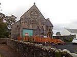 Upload another image | |||
| Parish Church Of Saint Lawrence And Graveyard | 55°31′06″N 2°21′45″W / 55.518233°N 2.362451°W / 55.518233; -2.362451 (Parish Church Of Saint Lawrence And Graveyard) | Category B | 15224 |  Upload another image | |||
| Lochside House, Including Service Wing, Water Tower, Coach House, Former Stables, Lodge, Gatepiers, Boundary Wall, Steading And Steading Cottage | 55°32′50″N 2°19′08″W / 55.547243°N 2.31888°W / 55.547243; -2.31888 (Lochside House, Including Service Wing, Water Tower, Coach House, Former Stables, Lodge, Gatepiers, Boundary Wall, Steading And Steading Cottage) | Category B | 49457 | Upload Photo | |||
| Wellgate Including Outbuildings And Boundary Walls | 55°31′04″N 2°21′46″W / 55.517801°N 2.362716°W / 55.517801; -2.362716 (Wellgate Including Outbuildings And Boundary Walls) | Category C(S) | 19732 | 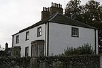 Upload another image | |||
| Morebattle, Templehall Inn | 55°31′02″N 2°21′43″W / 55.517265°N 2.361903°W / 55.517265; -2.361903 (Morebattle, Templehall Inn) | Category C(S) | 15228 | 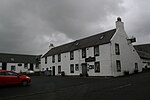 Upload another image | |||
| Corbet Tower | 55°30′30″N 2°21′19″W / 55.508236°N 2.355218°W / 55.508236; -2.355218 (Corbet Tower) | Category B | 15229 | Upload Photo |
Key
The scheme for classifying buildings in Scotland is:
- Category A: "buildings of national or international importance, either architectural or historic; or fine, little-altered examples of some particular period, style or building type."[1]
- Category B: "buildings of regional or more than local importance; or major examples of some particular period, style or building type, which may have been altered."[1]
- Category C: "buildings of local importance; lesser examples of any period, style, or building type, as originally constructed or moderately altered; and simple traditional buildings which group well with other listed buildings."[1]
In March 2016 there were 47,288 listed buildings in Scotland. Of these, 8% were Category A, and 50% were Category B, with the remaining 42% being Category C.[2]
Notes
- ^ Sometimes known as OSGB36, the grid reference (where provided) is based on the British national grid reference system used by the Ordnance Survey.
• "Guide to National Grid". Ordnance Survey. Retrieved 12 December 2007.
• "Get-a-map". Ordnance Survey. Retrieved 17 December 2007. - ^ Historic Environment Scotland assign a unique alphanumeric identifier to each designated site in Scotland, for listed buildings this always begins with "LB", for example "LB12345".
References
- All entries, addresses and coordinates are based on data from Historic Scotland. This data falls under the Open Government Licence
- ^ a b c "What is Listing?". Historic Environment Scotland. Retrieved 29 May 2018.
- ^ Scotland's Historic Environment Audit 2016 (PDF). Historic Environment Scotland and the Built Environment Forum Scotland. pp. 15–16. Retrieved 29 May 2018.
- v
- t
- e
- Abbey St Bathans
- Ancrum
- Ashkirk
- Ayton
- Bedrule
- Bowden
- Broughton, Glenholm and Kilbucho
- Bunkle and Preston
- Caddonfoot
- Castleton
- Cavers
- Channelkirk
- Chirnside
- Cockburnspath
- Coldingham
- Coldstream
- Crailing
- Cranshaws
- Drumelzier
- Duns
- Earlston
- Eccles
- Eckford
- Eddleston
- Ednam
- Edrom
- Ettrick
- Eyemouth
- Fala and Soutra
- Fogo
- Foulden
- Galashiels
- Gordon
- Greenlaw
- Hawick
- Heriot
- Hobkirk
- Hownam
- Hume
- Hutton
- Innerleithen
- Jedburgh
- Kelso
- Kirkhope
- Kirkurd
- Ladykirk
- Langton
- Lauder
- Legerwood
- Lilliesleaf
- Linton
- Longformacus
- Lyne
- Makerstoun
- Manor
- Maxton
- Melrose
- Mertoun
- Minto
- Mordington
- Morebattle
- Nenthorn
- Newlands
- Oxnam
- Peebles
- Penicuik
- Polwarth
- Roberton
- Roxburgh
- Selkirk
- Skirling
- Smailholm
- Southdean
- Sprouston
- St Boswells
- Stichill
- Stobo
- Stow
- Swinton
- Teviothead
- Traquair
- Tweedsmuir
- Westruther
- Whitsome
- Yarrow
- Yetholm


