List of listed buildings in Mertoun, Scottish Borders
This is a list of listed buildings in the parish of Mertoun in the Scottish Borders, Scotland.
Map all coordinates using OpenStreetMap
Download coordinates as:
- KML
- GPX (all coordinates)
- GPX (primary coordinates)
- GPX (secondary coordinates)
List
| Name | Location | Date Listed | Grid Ref. [note 1] | Geo-coordinates | Notes | LB Number [note 2] | Image |
|---|---|---|---|---|---|---|---|
| Dovecote, Mertoun | 55°34′45″N 2°36′14″W / 55.579208°N 2.604016°W / 55.579208; -2.604016 (Dovecote, Mertoun) | Category A | 15112 |  Upload another image | |||
| Wallace Monument And Ornamental Urn, In Policies Of Bemersyde House | 55°35′10″N 2°38′58″W / 55.586191°N 2.649528°W / 55.586191; -2.649528 (Wallace Monument And Ornamental Urn, In Policies Of Bemersyde House) | Category B | 15122 |  Upload another image | |||
| Old Mertoun House | 55°34′47″N 2°36′16″W / 55.579718°N 2.604563°W / 55.579718; -2.604563 (Old Mertoun House) | Category B | 15111 |  Upload Photo | |||
| Dovecot, Dryburgh Abbey House | 55°34′31″N 2°38′56″W / 55.575411°N 2.648937°W / 55.575411; -2.648937 (Dovecot, Dryburgh Abbey House) | Category B | 15116 | 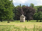 Upload another image | |||
| Mertoun Bridge | 55°34′50″N 2°37′14″W / 55.580528°N 2.620501°W / 55.580528; -2.620501 (Mertoun Bridge) | Category B | 15113 |  Upload another image | |||
| Stirling Tower, Dryburgh | 55°34′50″N 2°39′03″W / 55.580595°N 2.650815°W / 55.580595; -2.650815 (Stirling Tower, Dryburgh) | Category B | 15125 |  Upload another image | |||
| West Lodge Gateway, Gladswood | 55°36′07″N 2°39′38″W / 55.602046°N 2.660471°W / 55.602046; -2.660471 (West Lodge Gateway, Gladswood) | Category B | 15127 |  Upload another image | |||
| Dryburgh, K6 Telephone Kiosk At Post Office | 55°34′50″N 2°38′58″W / 55.58054°N 2.649355°W / 55.58054; -2.649355 (Dryburgh, K6 Telephone Kiosk At Post Office) | Category B | 19114 | Upload Photo | |||
| Tomb of Sir Walter Scott, King James obelisk, headstone of Field Marshall Earl Haig and memorials in burial ground to the north of Dryburgh Abbey | 55°34′38″N 2°38′58″W / 55.57726°N 2.649349°W / 55.57726; -2.649349 (Tomb of Sir Walter Scott, King James obelisk, headstone of Field Marshall Earl Haig and memorials in burial ground to the north of Dryburgh Abbey) | Category A | 15114 |  Upload another image | |||
| Temple Of The Muses, Dryburgh Mains | 55°34′53″N 2°39′16″W / 55.581367°N 2.654397°W / 55.581367; -2.654397 (Temple Of The Muses, Dryburgh Mains) | Category B | 15123 |  Upload another image | |||
| Orchard Gate, Dryburgh | 55°34′50″N 2°38′58″W / 55.580423°N 2.649401°W / 55.580423; -2.649401 (Orchard Gate, Dryburgh) | Category B | 15124 |  Upload another image | |||
| Old Gladswood House, Gladswood Farm | 55°36′08″N 2°39′37″W / 55.602335°N 2.660206°W / 55.602335; -2.660206 (Old Gladswood House, Gladswood Farm) | Category B | 15129 | Upload Photo | |||
| Mertoun House | 55°34′40″N 2°36′27″W / 55.577645°N 2.607624°W / 55.577645; -2.607624 (Mertoun House) | Category A | 15110 | 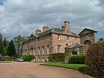 Upload another image | |||
| Dryburgh Abbey House Including Sundial | 55°34′34″N 2°38′51″W / 55.576245°N 2.647635°W / 55.576245; -2.647635 (Dryburgh Abbey House Including Sundial) | Category B | 15115 | 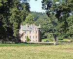 Upload another image | |||
| Ice House, Dryburgh Abbey House | 55°34′35″N 2°39′01″W / 55.57633°N 2.650253°W / 55.57633; -2.650253 (Ice House, Dryburgh Abbey House) | Category B | 15118 | Upload Photo | |||
| Sundial, Bemersyde House | 55°35′30″N 2°38′54″W / 55.591688°N 2.648286°W / 55.591688; -2.648286 (Sundial, Bemersyde House) | Category B | 15121 | 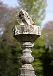 Upload another image | |||
| Gladswood | 55°36′11″N 2°39′09″W / 55.602996°N 2.652424°W / 55.602996; -2.652424 (Gladswood) | Category B | 19714 | Upload Photo | |||
| Old Corn-Mill, Dryburgh | 55°34′34″N 2°38′45″W / 55.576228°N 2.645715°W / 55.576228; -2.645715 (Old Corn-Mill, Dryburgh) | Category B | 15117 | Upload Photo | |||
| Mertoun Mill | 55°34′56″N 2°37′19″W / 55.582219°N 2.621845°W / 55.582219; -2.621845 (Mertoun Mill) | Category C(S) | 13876 | Upload Photo | |||
| St Boswell's, Mertoun Glebe | 55°35′05″N 2°37′03″W / 55.584694°N 2.617458°W / 55.584694; -2.617458 (St Boswell's, Mertoun Glebe) | Category B | 49974 | Upload Photo | |||
| Dryburgh Abbey House Stables | 55°34′35″N 2°38′46″W / 55.576514°N 2.646053°W / 55.576514; -2.646053 (Dryburgh Abbey House Stables) | Category B | 19668 | Upload Photo | |||
| Mertoun Church | 55°34′43″N 2°36′41″W / 55.578516°N 2.611397°W / 55.578516; -2.611397 (Mertoun Church) | Category B | 15108 |  Upload another image | |||
| Old Churchyard | 55°34′42″N 2°35′51″W / 55.578369°N 2.597373°W / 55.578369; -2.597373 (Old Churchyard) | Category B | 15109 | Upload Photo | |||
| Bemersyde House | 55°35′31″N 2°38′55″W / 55.591865°N 2.64867°W / 55.591865; -2.64867 (Bemersyde House) | Category A | 15120 |  Upload another image |
Key
The scheme for classifying buildings in Scotland is:
- Category A: "buildings of national or international importance, either architectural or historic; or fine, little-altered examples of some particular period, style or building type."[1]
- Category B: "buildings of regional or more than local importance; or major examples of some particular period, style or building type, which may have been altered."[1]
- Category C: "buildings of local importance; lesser examples of any period, style, or building type, as originally constructed or moderately altered; and simple traditional buildings which group well with other listed buildings."[1]
In March 2016 there were 47,288 listed buildings in Scotland. Of these, 8% were Category A, and 50% were Category B, with the remaining 42% being Category C.[2]
Notes
- ^ Sometimes known as OSGB36, the grid reference (where provided) is based on the British national grid reference system used by the Ordnance Survey.
• "Guide to National Grid". Ordnance Survey. Retrieved 12 December 2007.
• "Get-a-map". Ordnance Survey. Retrieved 17 December 2007. - ^ Historic Environment Scotland assign a unique alphanumeric identifier to each designated site in Scotland, for listed buildings this always begins with "LB", for example "LB12345".
References
- All entries, addresses and coordinates are based on data from Historic Scotland. This data falls under the Open Government Licence
- ^ a b c "What is Listing?". Historic Environment Scotland. Retrieved 29 May 2018.
- ^ Scotland's Historic Environment Audit 2016 (PDF). Historic Environment Scotland and the Built Environment Forum Scotland. pp. 15–16. Retrieved 29 May 2018.
- v
- t
- e
- Abbey St Bathans
- Ancrum
- Ashkirk
- Ayton
- Bedrule
- Bowden
- Broughton, Glenholm and Kilbucho
- Bunkle and Preston
- Caddonfoot
- Castleton
- Cavers
- Channelkirk
- Chirnside
- Cockburnspath
- Coldingham
- Coldstream
- Crailing
- Cranshaws
- Drumelzier
- Duns
- Earlston
- Eccles
- Eckford
- Eddleston
- Ednam
- Edrom
- Ettrick
- Eyemouth
- Fala and Soutra
- Fogo
- Foulden
- Galashiels
- Gordon
- Greenlaw
- Hawick
- Heriot
- Hobkirk
- Hownam
- Hume
- Hutton
- Innerleithen
- Jedburgh
- Kelso
- Kirkhope
- Kirkurd
- Ladykirk
- Langton
- Lauder
- Legerwood
- Lilliesleaf
- Linton
- Longformacus
- Lyne
- Makerstoun
- Manor
- Maxton
- Melrose
- Mertoun
- Minto
- Mordington
- Morebattle
- Nenthorn
- Newlands
- Oxnam
- Peebles
- Penicuik
- Polwarth
- Roberton
- Roxburgh
- Selkirk
- Skirling
- Smailholm
- Southdean
- Sprouston
- St Boswells
- Stichill
- Stobo
- Stow
- Swinton
- Teviothead
- Traquair
- Tweedsmuir
- Westruther
- Whitsome
- Yarrow
- Yetholm


