List of listed buildings in Westruther, Scottish Borders
This is a list of listed buildings in the parish of Westruther in the Scottish Borders, Scotland.
Map all coordinates using OpenStreetMap
Download coordinates as:
- KML
- GPX (all coordinates)
- GPX (primary coordinates)
- GPX (secondary coordinates)
List
| Name | Location | Date Listed | Grid Ref. [note 1] | Geo-coordinates | Notes | LB Number [note 2] | Image |
|---|---|---|---|---|---|---|---|
| Spottiswoode, Stable Block, Groom's House, Dog Kennel, "Bear's Den", Glasshouse, Sundial And Rustic Shelter In Walled Garden, Icehouse, Doocot And Well, And Boundary Walls To Former Spottiswoode House | 55°44′23″N 2°37′53″W / 55.739774°N 2.631388°W / 55.739774; -2.631388 (Spottiswoode, Stable Block, Groom's House, Dog Kennel, "Bear's Den", Glasshouse, Sundial And Rustic Shelter In Walled Garden, Icehouse, Doocot And Well, And Boundary Walls To Former Spottiswoode House) | Category B | 19653 |  Upload Photo | |||
| Wedderlie House | 55°45′21″N 2°34′34″W / 55.755823°N 2.576104°W / 55.755823; -2.576104 (Wedderlie House) | Category A | 19740 | 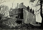 Upload another image | |||
| Bassendean House | 55°42′18″N 2°35′37″W / 55.704929°N 2.59359°W / 55.704929; -2.59359 (Bassendean House) | Category B | 15345 | Upload Photo | |||
| Spottiswoode, Pyatshaw Archway | 55°43′32″N 2°39′49″W / 55.725568°N 2.663702°W / 55.725568; -2.663702 (Spottiswoode, Pyatshaw Archway) | Category C(S) | 19651 | Upload Photo | |||
| Spottiswoode, Bruntaburn Archway | 55°44′22″N 2°38′29″W / 55.739462°N 2.641321°W / 55.739462; -2.641321 (Spottiswoode, Bruntaburn Archway) | Category C(S) | 19652 | Upload Photo | |||
| Spottiswoode, West Lodge | 55°44′22″N 2°38′28″W / 55.739516°N 2.641163°W / 55.739516; -2.641163 (Spottiswoode, West Lodge) | Category C(S) | 17418 | Upload Photo | |||
| Spottiswoode, Eagle Or Clock Lodges | 55°43′11″N 2°37′15″W / 55.719683°N 2.620828°W / 55.719683; -2.620828 (Spottiswoode, Eagle Or Clock Lodges) | Category B | 19654 | Upload Photo | |||
| Ruin Of Old Church And Graveyard, Westruther | 55°44′33″N 2°35′03″W / 55.742523°N 2.584126°W / 55.742523; -2.584126 (Ruin Of Old Church And Graveyard, Westruther) | Category B | 15343 | Upload Photo | |||
| Ruin Of Bassendean Church (St Mary) | 55°42′13″N 2°35′20″W / 55.703639°N 2.588972°W / 55.703639; -2.588972 (Ruin Of Bassendean Church (St Mary)) | Category B | 15344 | Upload Photo | |||
| The Old Thistle Inn, Westruther | 55°44′32″N 2°35′05″W / 55.742143°N 2.58479°W / 55.742143; -2.58479 (The Old Thistle Inn, Westruther) | Category B | 15346 | Upload Photo | |||
| Evelaw Tower | 55°45′55″N 2°32′30″W / 55.765235°N 2.541579°W / 55.765235; -2.541579 (Evelaw Tower) | Category B | 17419 | Upload Photo | |||
| Coach Building Wedderlie | 55°45′23″N 2°34′30″W / 55.756305°N 2.575011°W / 55.756305; -2.575011 (Coach Building Wedderlie) | Category B | 15347 | Upload Photo |
Key
The scheme for classifying buildings in Scotland is:
- Category A: "buildings of national or international importance, either architectural or historic; or fine, little-altered examples of some particular period, style or building type."[1]
- Category B: "buildings of regional or more than local importance; or major examples of some particular period, style or building type, which may have been altered."[1]
- Category C: "buildings of local importance; lesser examples of any period, style, or building type, as originally constructed or moderately altered; and simple traditional buildings which group well with other listed buildings."[1]
In March 2016 there were 47,288 listed buildings in Scotland. Of these, 8% were Category A, and 50% were Category B, with the remaining 42% being Category C.[2]
Notes
- ^ Sometimes known as OSGB36, the grid reference (where provided) is based on the British national grid reference system used by the Ordnance Survey.
• "Guide to National Grid". Ordnance Survey. Retrieved 12 December 2007.
• "Get-a-map". Ordnance Survey. Retrieved 17 December 2007. - ^ Historic Environment Scotland assign a unique alphanumeric identifier to each designated site in Scotland, for listed buildings this always begins with "LB", for example "LB12345".
References
- All entries, addresses and coordinates are based on data from Historic Scotland. This data falls under the Open Government Licence
- ^ a b c "What is Listing?". Historic Environment Scotland. Retrieved 29 May 2018.
- ^ Scotland's Historic Environment Audit 2016 (PDF). Historic Environment Scotland and the Built Environment Forum Scotland. pp. 15–16. Retrieved 29 May 2018.
- v
- t
- e
- Abbey St Bathans
- Ancrum
- Ashkirk
- Ayton
- Bedrule
- Bowden
- Broughton, Glenholm and Kilbucho
- Bunkle and Preston
- Caddonfoot
- Castleton
- Cavers
- Channelkirk
- Chirnside
- Cockburnspath
- Coldingham
- Coldstream
- Crailing
- Cranshaws
- Drumelzier
- Duns
- Earlston
- Eccles
- Eckford
- Eddleston
- Ednam
- Edrom
- Ettrick
- Eyemouth
- Fala and Soutra
- Fogo
- Foulden
- Galashiels
- Gordon
- Greenlaw
- Hawick
- Heriot
- Hobkirk
- Hownam
- Hume
- Hutton
- Innerleithen
- Jedburgh
- Kelso
- Kirkhope
- Kirkurd
- Ladykirk
- Langton
- Lauder
- Legerwood
- Lilliesleaf
- Linton
- Longformacus
- Lyne
- Makerstoun
- Manor
- Maxton
- Melrose
- Mertoun
- Minto
- Mordington
- Morebattle
- Nenthorn
- Newlands
- Oxnam
- Peebles
- Penicuik
- Polwarth
- Roberton
- Roxburgh
- Selkirk
- Skirling
- Smailholm
- Southdean
- Sprouston
- St Boswells
- Stichill
- Stobo
- Stow
- Swinton
- Teviothead
- Traquair
- Tweedsmuir
- Westruther
- Whitsome
- Yarrow
- Yetholm


