Grade II* listed buildings in Gloucester
Map all coordinates using OpenStreetMap
Download coordinates as:
- KML
- GPX (all coordinates)
- GPX (primary coordinates)
- GPX (secondary coordinates)
There are over 20,000 Grade II* listed buildings in England. This page is a list of these buildings in the district of Gloucester in Gloucestershire.
Gloucester
| Name | Location | Type | Completed [note 1] | Date designated | Grid ref.[note 2] Geo-coordinates | Entry number [note 3] | Image |
|---|---|---|---|---|---|---|---|
| Church of St James | Quedgeley, Gloucester | Parish Church | 14th century | 10 January 1955 | SO8071614182 51°49′33″N 2°16′52″W / 51.82592°N 2.281213°W / 51.82592; -2.281213 (Church of St James) | 1090771 |  More images |
| Bearland House and attached Railings and Gates to Forecourt | Gloucester | House | Late 17th century or Early 18th century | 7 September 1970 | SO8293918570 51°51′56″N 2°14′57″W / 51.865445°N 2.249176°W / 51.865445; -2.249176 (Bearland House and attached Railings and Gates to Forecourt) | 1245728 |  More images |
| Bearland Lodge | Gloucester | Town House | c. 1720 | 23 January 1952 | SO8295718563 51°51′55″N 2°14′56″W / 51.865382°N 2.248914°W / 51.865382; -2.248914 (Bearland Lodge) | 1245727 | 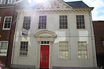 More images |
| Boundary Wall to North West Corner of Friary Site, Blackfriars | Gloucester | Boundary Wall | 1540–1545 | 12 March 1973 | SO8294918461 51°51′52″N 2°14′56″W / 51.864465°N 2.249025°W / 51.864465; -2.249025 (Boundary Wall to North West Corner of Friary Site, Blackfriars) | 1245990 |  More images |
| Central Block to HM Prison | Gloucester | Prison | 1784–1790 | 12 March 1973 | SO8281318525 51°51′54″N 2°15′04″W / 51.865036°N 2.251003°W / 51.865036; -2.251003 (Central Block to HM Prison) | 1245474 | 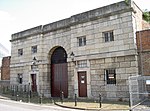 More images |
| Chapel of St Mary Magdalene Remains of Chapel of St Mary Magdalene | Gloucester | Chapel | Mid 12th century | 23 January 1952 | SO8432318988 51°52′09″N 2°13′45″W / 51.869244°N 2.229096°W / 51.869244; -2.229096 (Chapel of St Mary Magdalene Remains of Chapel of St Mary Magdalene) | 1245744 | 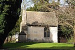 More images |
| Church of St Barnabas | Tuffley, Gloucester | Parish Church | 1938–1940 | 9 March 1982 | SO8339215808 51°50′26″N 2°14′33″W / 51.840626°N 2.242463°W / 51.840626; -2.242463 (Church of St Barnabas) | 1271790 | 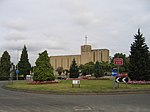 More images |
| Church of St John, Northgate | Gloucester | Methodist Chapel | 1972 | 23 January 1952 | SO8324318683 51°51′59″N 2°14′41″W / 51.86647°N 2.244766°W / 51.86647; -2.244766 (Church of St John, Northgate) | 1245673 | 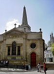 More images |
| Church of St Lawrence | Barnwood, Gloucester | Parish Church | Mid 12th century | 10 January 1955 | SO8584117755 51°51′30″N 2°12′25″W / 51.858199°N 2.206998°W / 51.858199; -2.206998 (Church of St Lawrence) | 1271586 |  More images |
| Church of St Swithun | Hempsted, Gloucester | Parish Church | 14th century | 10 January 1955 | SO8135917034 51°51′06″N 2°16′19″W / 51.851584°N 2.272038°W / 51.851584; -2.272038 (Church of St Swithun) | 1271743 | 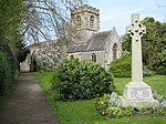 More images |
| Deaf Institute | Gloucester | Town House | c. 1690 | 23 January 1952 | SO8294618856 51°52′05″N 2°14′57″W / 51.868016°N 2.249088°W / 51.868016; -2.249088 (Deaf Institute) | 1245666 | 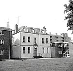 |
| Dulverton House (Kings School) | Gloucester | Abbey | 13th century | 23 January 1952 | SO8317018847 51°52′05″N 2°14′45″W / 51.867942°N 2.245835°W / 51.867942; -2.245835 (Dulverton House (Kings School)) | 1245957 | 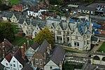 More images |
| Folk Museum | Gloucester | Jettied House | c. 1645 | 23 January 1952 | SO8286218771 51°52′02″N 2°15′01″W / 51.86725°N 2.250304°W / 51.86725; -2.250304 (Folk Museum) | 1245075 | 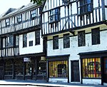 More images |
| Folk Museum (Bishop Hooper's Lodging) | Gloucester | Jettied House | c. 1520 | 23 January 1952 | SO8287118765 51°52′02″N 2°15′01″W / 51.867196°N 2.250173°W / 51.867196; -2.250173 (Folk Museum (Bishop Hooper's Lodging)) | 1245071 |  More images |
| Horton Road Hospital including Area Railings | Gloucester | Fireproof Building | 1814–1823 | 28 May 1991 | SO8438318527 51°51′54″N 2°13′42″W / 51.865101°N 2.228203°W / 51.865101; -2.228203 (Horton Road Hospital including Area Railings) | 1271680 |  More images |
| Kings Board, Hillfield Gardens | Gloucester | Gazebo | Late 18th century | 23 January 1952 | SO8425618976 51°52′09″N 2°13′48″W / 51.869134°N 2.230068°W / 51.869134; -2.230068 (Kings Board, Hillfield Gardens) | 1245719 | 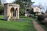 More images |
| King Edward's Gate | Gloucester | House | 1998 | 23 January 1952 | SO8303118732 51°52′01″N 2°14′52″W / 51.866904°N 2.247848°W / 51.866904; -2.247848 (King Edward's Gate) | 1245909 |  More images |
| Kings School and Remains of Abbots Lodging | Gloucester | Bishops Palace | 1541 | 12 March 1973 | SO8311518902 51°52′06″N 2°14′48″W / 51.868435°N 2.246636°W / 51.868435; -2.246636 (Kings School and Remains of Abbots Lodging) | 1245960 | More images |
| Northgate House and attached Walls and Railings to Forecourt | Gloucester | House | Mid to late 17th century | 23 January 1952 | SO8361018804 51°52′03″N 2°14′22″W / 51.867569°N 2.239442°W / 51.867569; -2.239442 (Northgate House and attached Walls and Railings to Forecourt) | 1271700 |  More images |
| 20, College Green and part of Abbey Precinct Wall | Gloucester | House | 18th century | 12 March 1973 | SO8310918694 51°52′00″N 2°14′48″W / 51.866565°N 2.246713°W / 51.866565; -2.246713 (20, College Green and part of Abbey Precinct Wall) | 1245904 |  More images |
| Robert Raikes' House | Gloucester | House | 19th century | 23 January 1952 | SO8306918463 51°51′52″N 2°14′50″W / 51.864487°N 2.247282°W / 51.864487; -2.247282 (Robert Raikes' House) | 1271757 |  More images |
| Roman Catholic Church of St Peter | Gloucester | Roman Catholic Church | 1860–1868 | 12 March 1973 | SO8351218781 51°52′02″N 2°14′27″W / 51.867359°N 2.240864°W / 51.867359; -2.240864 (Roman Catholic Church of St Peter) | 1245721 |  More images |
| Scriven's Conduit | Gloucester | Conduit Head | 1636 | 25 January 1952 | SO8422418971 51°52′09″N 2°13′50″W / 51.869088°N 2.230533°W / 51.869088; -2.230533 (Scriven's Conduit) | 1245720 |  More images |
| Selwyn Care Home and attached Wall | Matson, Gloucester | Manor House | c. 1575 | 23 January 1952 | SO8481515463 51°50′15″N 2°13′18″W / 51.837565°N 2.221794°W / 51.837565; -2.221794 (Selwyn Care Home and attached Wall) | 1245730 |  |
| Sherborne House | Gloucester | House | c. 1825 | 25 January 1952 | SO8296817989 51°51′37″N 2°14′55″W / 51.860222°N 2.248726°W / 51.860222; -2.248726 (Sherborne House) | 1245621 |  |
| St Margarets Chapel | Gloucester | Chapel | Before 1163 | 23 January 1952 | SO8411418909 51°52′07″N 2°13′56″W / 51.868528°N 2.232127°W / 51.868528; -2.232127 (St Margarets Chapel) | 1245723 |  More images |
| St Mary De Crypt Grammar School | Gloucester | Church Hall | 1862 | 23 January 1952 | SO8308118439 51°51′51″N 2°14′50″W / 51.864271°N 2.247107°W / 51.864271; -2.247107 (St Mary De Crypt Grammar School) | 1271755 |  More images |
| The Deanery and attached Forecourt Walls and Railings | Gloucester | House | 1731–1741 | 23 January 1952 | SO8303718882 51°52′06″N 2°14′52″W / 51.868253°N 2.247768°W / 51.868253; -2.247768 (The Deanery and attached Forecourt Walls and Railings) | 1271712 | 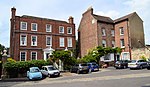 More images |
| The Judges Lodgings and attached Front Piers Walls and Balustrades | Gloucester | Apartment | 1998 | 25 January 1952 | SO8299617975 51°51′36″N 2°14′54″W / 51.860097°N 2.248318°W / 51.860097; -2.248318 (The Judges Lodgings and attached Front Piers Walls and Balustrades) | 1245622 | 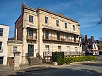 |
| Tower of the former Church of St Michael | Gloucester | Parish Church | 1455–1472 | 23 January 1952 | SO8317018541 51°51′55″N 2°14′45″W / 51.865191°N 2.24582°W / 51.865191; -2.24582 (Tower of the former Church of St Michael) | 1245822 |  More images |
| Village Cross (at Corner of Rea Lane) | Hempsted, Gloucester | Village Cross | Early 15th century | 10 January 1955 | SO8146716949 51°51′03″N 2°16′14″W / 51.850823°N 2.270465°W / 51.850823; -2.270465 (Village Cross (at Corner of Rea Lane)) | 1271745 | 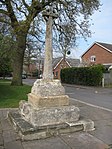 More images |
| Well Cross in Robins Wood Hill Country Park at SO 838 158 | Gloucester | Cistern | 12th century or 13th century | 15 December 1998 | SO8387015848 51°50′28″N 2°14′08″W / 51.841°N 2.235527°W / 51.841; -2.235527 (Well Cross in Robins Wood Hill Country Park at SO 838 158) | 1245660 | 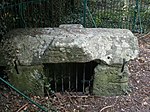 |
| Winston Hall | Gloucester | Town House | 1750 | 23 January 1952 | SO8323818375 51°51′49″N 2°14′41″W / 51.863701°N 2.244824°W / 51.863701; -2.244824 (Winston Hall) | 1271655 | 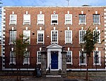 More images |
| House (6, Westgate Street) | Gloucester | House | 16th century | 12 March 1973 | SO8315318590 51°51′56″N 2°14′46″W / 51.865631°N 2.246069°W / 51.865631; -2.246069 (House (6, Westgate Street)) | 1245438 |  |
| House (14 Westgate Street) | Gloucester | House | Early to Mid 18th century | 23 January 1952 | SO8313918607 51°51′57″N 2°14′47″W / 51.865784°N 2.246273°W / 51.865784; -2.246273 (House (14 Westgate Street)) | 1245445 | 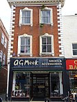 |
| House (33, Westgate Street) | Gloucester | House | C20 | 12 March 1973 | SO8307618626 51°51′57″N 2°14′50″W / 51.865952°N 2.247189°W / 51.865952; -2.247189 (House (33, Westgate Street)) | 1271925 |  |
| 47 and 49, Westgate Street | Gloucester | House | Late 18th century | 23 January 1952 | SO8304518649 51°51′58″N 2°14′52″W / 51.866158°N 2.24764°W / 51.866158; -2.24764 (47 and 49, Westgate Street) | 1271930 | 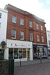 More images |
| 66, Westgate Street | Gloucester | Shop | 19th century | 23 January 1952 | SO8300418708 51°52′00″N 2°14′54″W / 51.866688°N 2.248239°W / 51.866688; -2.248239 (66, Westgate Street) | 1245228 |  More images |
| House (74 and 76, Westgate Street) | Gloucester | House | After Early 16th century | 10 December 1973 | SO8298618725 51°52′01″N 2°14′55″W / 51.86684°N 2.248501°W / 51.86684; -2.248501 (House (74 and 76, Westgate Street)) | 1245230 | 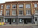 More images |
| House (1 and 3, Berkeley Street/56 and 61, Westgate Street) | Gloucester | House | C20 | 23 January 1952 | SO8301918662 51°51′59″N 2°14′53″W / 51.866274°N 2.248018°W / 51.866274; -2.248018 (House (1 and 3, Berkeley Street/56 and 61, Westgate Street)) | 1245225 | 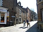 More images |
| 14, College Green | Gloucester | House | Early 15th century | 23 January 1952 | SO8300318854 51°52′05″N 2°14′54″W / 51.868°N 2.24826°W / 51.868; -2.24826 (14, College Green) | 1245896 | 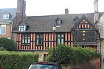 More images |
| 9, College Green | Gloucester | House | 1708–1709 | 23 January 1952 | SO8298918796 51°52′03″N 2°14′54″W / 51.867478°N 2.248461°W / 51.867478; -2.248461 (9, College Green) | 1271600 |  More images |
| House (29 and 31, Southgate Street) | Gloucester | House | C20 | 23 January 1952 | SO8309618451 51°51′52″N 2°14′49″W / 51.86438°N 2.24689°W / 51.86438; -2.24689 (House (29 and 31, Southgate Street)) | 1271754 | 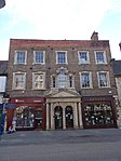 More images |
| House (5–11, College Street) | Gloucester | House | Later alterations | 23 January 1952 | SO8302318714 51°52′00″N 2°14′53″W / 51.866742°N 2.247963°W / 51.866742; -2.247963 (House (5–11, College Street)) | 1245908 |  More images |
| House (13, Ladybellegate Street) | Gloucester | House | c. 1540 | 23 January 1952 | SO8294118428 51°51′51″N 2°14′57″W / 51.864168°N 2.24914°W / 51.864168; -2.24914 (House (13, Ladybellegate Street)) | 1245752 | 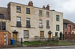 |
| House (15, Ladybellegate Street) | Gloucester | House | c. 1540 | 23 January 1952 | SO8293818423 51°51′51″N 2°14′57″W / 51.864123°N 2.249183°W / 51.864123; -2.249183 (House (15, Ladybellegate Street)) | 1245753 | |
| House (17, Ladybellegate Street) | Gloucester | House | c. 1540 | 23 January 1952 | SO8293518418 51°51′51″N 2°14′57″W / 51.864078°N 2.249226°W / 51.864078; -2.249226 (House (17, Ladybellegate Street)) | 1245754 | |
| 3, Millers Green | Gloucester | Abbey | 12th century | 23 January 1952 | SO8309618870 51°52′05″N 2°14′49″W / 51.868147°N 2.24691°W / 51.868147; -2.24691 (3, Millers Green) | 1271714 | 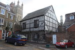 More images |
| 12–18 Brunswick Square | Gloucester | Terrace | 1825 | 23 January 1952 | SO 8299618105 51°51′41″N 2°14′53″W / 51.861420°N 2.248149°W / 51.861420; -2.248149 (12–18 Brunswick Square) | 1245974 | 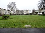 More images |
| War Memorial to the Royal Gloucestershire Hussars Yeomanry | College Green, Gloucester Cathedral, Gloucester | War memorial | 20th century | 15 December 1988 | SO830188 51°52′03″N 2°14′53″W / 51.8676°N 2.248°W / 51.8676; -2.248 (War Memorial to the Royal Gloucestershire Hussars Yeomanry) | 1245906 |  More images |
Notes
- ^ The date given is the date used by Historic England as significant for the initial building or that of an important part in the structure's description.
- ^ Sometimes known as OSGB36, the grid reference is based on the British national grid reference system used by the Ordnance Survey.
- ^ The "List Entry Number" is a unique number assigned to each listed building and scheduled monument by Historic England.
External links
- v
- t
- e
- Bedfordshire
- Berkshire
- Bristol
- Buckinghamshire
- Cambridgeshire
- Cheshire
- Cornwall
- Cumbria
- Derbyshire
- Devon
- Dorset
- Durham
- East Sussex
- East Riding of Yorkshire
- Essex
- Gloucestershire
- Greater London
- Greater Manchester
- Hampshire
- Herefordshire
- Hertfordshire
- Isle of Wight
- Kent
- Lancashire
- Leicestershire
- Lincolnshire
- Merseyside
- Norfolk
- North Yorkshire
- Northamptonshire
- Northumberland
- Nottinghamshire
- Oxfordshire
- Rutland
- Shropshire
- Somerset
- South Yorkshire
- Staffordshire
- Suffolk
- Surrey
- Tyne and Wear
- Warwickshire
- West Midlands
- West Sussex
- West Yorkshire
- Wiltshire
- Worcestershire
- Allerdale
- Amber Valley
- Ashford
- Babergh
- Barrow-in-Furness
- Basildon
- Basingstoke and Deane
- Bath and North East Somerset
- Bolsover
- Boston
- Bournemouth
- Bradford
- Braintree
- Breckland
- Brentwood
- Brighton and Hove
- Bristol
- Broadland
- Calderdale
- Cambridge
- Camden
- Canterbury
- Carlisle
- Castle Point
- Chelmsford
- Cheltenham
- Cherwell
- Cheshire East
- Cheshire West and Chester
- Chesterfield
- Chiltern
- Christchurch
- Colchester
- Copeland
- Corby
- Cotswold
- Craven
- Dartford
- Daventry
- Dover
- East Cambridgeshire
- Exeter
- Mendip
- North Somerset
- Poole
- Sedgemoor
- South Somerset
- Stoke-on-Trent
- Taunton Deane
- West Somerset
- York


