Grade II* listed buildings in Torridge
Map all coordinates using OpenStreetMap
Download coordinates as:
- KML
- GPX (all coordinates)
- GPX (primary coordinates)
- GPX (secondary coordinates)
There are over 20,000 Grade II* listed buildings in England. This page is a list of these buildings in the district of Torridge in Devon.
Torridge
| Name | Location | Type | Completed [note 1] | Date designated | Grid ref.[note 2] Geo-coordinates | Entry number [note 3] | Image |
|---|---|---|---|---|---|---|---|
| Church of St James | Abbots Bickington, Torridge | Parish Church | c. 1300 | 14 February 1958 | SS3847613261 50°53′46″N 4°17′54″W / 50.89618°N 4.298216°W / 50.89618; -4.298216 (Church of St James) | 1105113 |  More images |
| Church of St Helen | Abbotsham | Anglican Church | Late 19th century | 20 February 1958 | SS4245926415 51°00′56″N 4°14′50″W / 51.015475°N 4.247322°W / 51.015475; -4.247322 (Church of St Helen) | 1104408 | 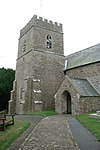 More images |
| Church of All Saints | Alverdiscott | Anglican Church | 1579 | 4 October 1960 | SS5195025257 51°00′27″N 4°06′42″W / 51.007592°N 4.111644°W / 51.007592; -4.111644 (Church of All Saints) | 1170720 |  More images |
| Portledge Manor | Alwington | Country house | Early 19th century | 22 January 1952 | SS3942224720 50°59′58″N 4°17′23″W / 50.999405°N 4.289831°W / 50.999405; -4.289831 (Portledge Manor) | 1170778 |  More images |
| Church of St James | Ashreigney | Parish Church | Pre-Perpendicular | 4 October 1960 | SS6286313626 50°54′21″N 3°57′07″W / 50.905771°N 3.951808°W / 50.905771; -3.951808 (Church of St James) | 1104609 |  More images |
| Bell Tower Cottage | Ashwater | House | 18th century | 21 January 1986 | SX3864695234 50°44′03″N 4°17′16″W / 50.734249°N 4.287868°W / 50.734249; -4.287868 (Bell Tower Cottage) | 1104661 |  Upload Photo |
| Old Parsonage | Beaford | House | C20 | 16 February 1989 | SS5508115641 50°55′19″N 4°03′48″W / 50.921977°N 4.063214°W / 50.921977; -4.063214 (Old Parsonage) | 1309063 | Upload Photo |
| Woolleigh Barton and adjoining Former Chapel | Woolleigh, Beaford | Farmhouse | 15th century or Earlier | 16 January 1952 | SS5317916872 50°55′57″N 4°05′27″W / 50.932558°N 4.090752°W / 50.932558; -4.090752 (Woolleigh Barton and adjoining Former Chapel) | 1105074 | Upload Photo |
| Church of St Mary | Bideford | Parish Church | Probably 15th century | 8 November 1949 | SS4538626423 51°00′59″N 4°12′20″W / 51.016342°N 4.205631°W / 51.016342; -4.205631 (Church of St Mary) | 1200893 |  More images |
| Lavington United Reformed Church | Bideford | Congregational Chapel | 1856-9 | 19 April 1993 | SS4535126826 51°01′12″N 4°12′23″W / 51.019953°N 4.206301°W / 51.019953; -4.206301 (Lavington United Reformed Church) | 1355163 |  More images |
| Masonic Hall, Caretaker's House at Rear and Garden Walls at Left and Rear | Bideford | House | 1692 | 8 November 1949 | SS4536526825 51°01′12″N 4°12′22″W / 51.019948°N 4.206101°W / 51.019948; -4.206101 (Masonic Hall, Caretaker's House at Rear and Garden Walls at Left and Rear) | 1025135 |  More images |
| Northdown Hall (part of Stella Maris School) | Bideford | House | Early 19th century | 24 July 1974 | SS4511826980 51°01′17″N 4°12′35″W / 51.021274°N 4.209686°W / 51.021274; -4.209686 (Northdown Hall (part of Stella Maris School)) | 1200936 | Upload Photo |
| 4 and 4a Bridgeland Street | Bideford, Torridge | House | 1692 | 8 November 1949 | SS4545426832 51°01′12″N 4°12′17″W / 51.020035°N 4.204836°W / 51.020035; -4.204836 (4 and 4a Bridgeland Street) | 1200874 | Upload Photo |
| 27 Bridgeland Street | Bideford | House | Probably early 1690s | 8 November 1949 | SS4540526794 51°01′11″N 4°12′20″W / 51.01968°N 4.205518°W / 51.01968; -4.205518 (27 Bridgeland Street) | 1025052 | Upload Photo |
| Nos 28 and 28a, Bridgeland St, including Pump and Milestone in Courtyard | Bideford | Apartment | 1949 | 8 November 1949 | SS4541826785 51°01′11″N 4°12′19″W / 51.019603°N 4.205329°W / 51.019603; -4.205329 (Nos 28 and 28a, Bridgeland St, including Pump and Milestone in Courtyard) | 1200879 | Upload Photo |
| 31 Bridgeland Street | Bideford | Apartment | 1992 | 6 May 1992 | SS4546026796 51°01′11″N 4°12′17″W / 51.019713°N 4.204736°W / 51.019713; -4.204736 (31 Bridgeland Street) | 1025001 | Upload Photo |
| Old Ford | Bideford | Farmhouse | 19th century | 8 November 1949 | SS4531025908 51°00′42″N 4°12′23″W / 51.011694°N 4.206494°W / 51.011694; -4.206494 (Old Ford) | 1200933 | Upload Photo |
| 74 and 74a High Street | Bideford | Apartment | 1999 | 8 November 1949 | SS4533726601 51°01′05″N 4°12′23″W / 51.017928°N 4.206405°W / 51.017928; -4.206405 (74 and 74a High Street) | 1208979 | Upload Photo |
| Church of St Mary | Black Torrington | Parish Church | 15th century | 14 February 1958 | SS4649305709 50°49′50″N 4°10′52″W / 50.830506°N 4.181135°W / 50.830506; -4.181135 (Church of St Mary) | 1105121 |  More images |
| Higher Braundsworthy Farmhouse | Black Torrington | Farmhouse | c. 1500 | 26 January 1989 | SS4387805856 50°49′52″N 4°13′06″W / 50.831127°N 4.218301°W / 50.831127; -4.218301 (Higher Braundsworthy Farmhouse) | 1326550 | Upload Photo |
| Hole Farmhouse | Black Torrington | Farmhouse | 16th century | 26 January 1989 | SS4701903822 50°48′49″N 4°10′22″W / 50.813689°N 4.172885°W / 50.813689; -4.172885 (Hole Farmhouse) | 1105119 | Upload Photo |
| Church of All Saints | Bradford | Parish Church | Norman origins | 26 January 1989 | SS4212707220 50°50′34″N 4°14′37″W / 50.842909°N 4.243733°W / 50.842909; -4.243733 (Church of All Saints) | 1105088 |  More images |
| Highstead Farmhouse | Bradford | Farmhouse | probably by the early 17th century | 14 February 1958 | SS4197605263 50°49′31″N 4°14′42″W / 50.825283°N 4.245032°W / 50.825283; -4.245032 (Highstead Farmhouse) | 1326575 | Upload Photo |
| Church of St John the Baptist | Bradworthy | Anglican Church | 18th century | 14 February 1958 | SS3246813981 50°54′03″N 4°23′02″W / 50.900936°N 4.383901°W / 50.900936; -4.383901 (Church of St John the Baptist) | 1163892 |  More images |
| Outbuilding, formerly Chapel, 25 Metres North East of Lower Alsworthy Farmhouse | Alfardisworthy, Bradworthy | Chapel | 15th century | 14 February 1958 | SS2941411765 50°52′48″N 4°25′35″W / 50.880132°N 4.426257°W / 50.880132; -4.426257 (Outbuilding, formerly Chapel, 25 Metres North East of Lower Alsworthy Farmhouse) | 1104971 | Upload Photo |
| Tackbeare Farmhouse | Bridgerule | Manor House | Late 16th century | 14 February 1958 | SS2574001887 50°47′25″N 4°28′25″W / 50.790291°N 4.473732°W / 50.790291; -4.473732 (Tackbeare Farmhouse) | 1104975 | Upload Photo |
| Palmer Headstone about 37m North of the West Tower of the Church of St Nicholas | Broadwoodwidger | Gravestone | Late 18th century | 21 January 1986 | SX4111489207 50°40′51″N 4°15′01″W / 50.680773°N 4.250328°W / 50.680773; -4.250328 (Palmer Headstone about 37m North of the West Tower of the Church of St Nicholas) | 1165023 | Upload Photo |
| Upcott | Broadwoodwidger | Farmhouse | late C15/early 16th century or earlier | 23 August 1957 | SX3966790114 50°41′19″N 4°16′16″W / 50.688526°N 4.271186°W / 50.688526; -4.271186 (Upcott) | 1164919 | Upload Photo |
| Church of St Mary and St Benedict | Buckland Brewer | Church | 18th century | 20 February 1958 | SS4189020915 50°57′57″N 4°15′11″W / 50.965899°N 4.253032°W / 50.965899; -4.253032 (Church of St Mary and St Benedict) | 1105169 | 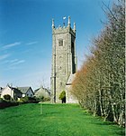 More images |
| Buckland House | Buckland Filleigh | Country House | core of earlier house | 4 October 1960 | SS4646809167 50°51′42″N 4°10′59″W / 50.861573°N 4.182941°W / 50.861573; -4.182941 (Buckland House) | 1104551 |  More images |
| Church of St Mary | Buckland Filleigh | Parish Church | Norman | 4 October 1960 | SS4655309152 50°51′41″N 4°10′54″W / 50.861461°N 4.181728°W / 50.861461; -4.181728 (Church of St Mary) | 1104552 |  More images |
| Church of St Michael | Bulkworthy | Church | 1874 | 18 December 1989 | SS3947414186 50°54′17″N 4°17′04″W / 50.90477°N 4.284443°W / 50.90477; -4.284443 (Church of St Michael) | 1104977 | 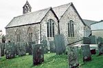 More images |
| No 16 including Forecourt Retaining Walls, Railings and Gates | Clovelly | House | Early 18th century | 20 February 1958 | SS3171824806 50°59′53″N 4°23′58″W / 50.997974°N 4.399563°W / 50.997974; -4.399563 (No 16 including Forecourt Retaining Walls, Railings and Gates) | 1104517 | Upload Photo |
| Nos 45/46 and 47 | Clovelly | House | 20 February 1958 | SS3183024852 50°59′54″N 4°23′53″W / 50.998421°N 4.39799°W / 50.998421; -4.39799 (Nos 45/46 and 47) | 1104522 |  | |
| No 53 (Crazy Kates) and No 54 | Clovelly | Fishermans House | Probably 18th century | 20 February 1958 | SS3184024867 50°59′55″N 4°23′52″W / 50.998558°N 4.397854°W / 50.998558; -4.397854 (No 53 (Crazy Kates) and No 54) | 1333120 |  |
| 59, 60 and 61 | Clovelly | House | Late 17th century or Early 18th century | 20 February 1958 | SS3186424822 50°59′53″N 4°23′51″W / 50.998161°N 4.397492°W / 50.998161; -4.397492 (59, 60 and 61) | 1333138 |  |
| Church of St John the Baptist and the Seven Maccabees | Cookbury | Parish Church | Norman origins | 14 February 1958 | SS4070806044 50°49′55″N 4°15′48″W / 50.831952°N 4.26336°W / 50.831952; -4.26336 (Church of St John the Baptist and the Seven Maccabees) | 1162728 |  More images |
| Chapple Cottage | Dolton | House | circa Mid 16th century | 10 March 1988 | SS5576510663 50°52′39″N 4°03′05″W / 50.877413°N 4.051521°W / 50.877413; -4.051521 (Chapple Cottage) | 1333048 | Upload Photo |
| Church of St Edmund | Dolton | Cross | Saxon | 4 October 1960 | SS5700312012 50°53′23″N 4°02′04″W / 50.889844°N 4.034464°W / 50.889844; -4.034464 (Church of St Edmund) | 1104629 |  More images |
| Stafford Barton | Dolton | House | 1956 | 20 December 1956 | SS5843011463 50°53′07″N 4°00′50″W / 50.885262°N 4.013976°W / 50.885262; -4.013976 (Stafford Barton) | 1104627 | 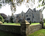 More images |
| Church of St Michael and All Angels | Great Torrington | Parish Church | Possibly 13th century | 19 March 1951 | SS4950519196 50°57′09″N 4°08′38″W / 50.952494°N 4.143958°W / 50.952494; -4.143958 (Church of St Michael and All Angels) | 1104787 |  More images |
| Market House | Great Torrington | House | 1842 | 19 March 1951 | SS4957019087 50°57′06″N 4°08′35″W / 50.951531°N 4.142988°W / 50.951531; -4.142988 (Market House) | 1104742 | 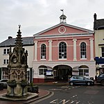 More images |
| Palmer House including Garden Wall | Great Torrington | House | 1752 | 19 March 1951 | SS4943719233 50°57′10″N 4°08′42″W / 50.952808°N 4.14494°W / 50.952808; -4.14494 (Palmer House including Garden Wall) | 1104777 | 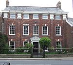 More images |
| 28 South Street | Great Torrington | House | 1701 | 3 April 1973 | SS4950519065 50°57′05″N 4°08′38″W / 50.951316°N 4.143904°W / 50.951316; -4.143904 (28 South Street) | 1104743 | Upload Photo |
| Church of St Peter and St James | Halwill | Parish Church | 14th century or earlier | 14 February 1958 | SX4272499431 50°46′23″N 4°13′55″W / 50.773082°N 4.231921°W / 50.773082; -4.231921 (Church of St Peter and St James) | 1104639 |  More images |
| Winsford Hospital | Halwill Junction, Halwill | Conservatory | C20 | 15 April 1978 | SX4454599993 50°46′43″N 4°12′23″W / 50.778623°N 4.206353°W / 50.778623; -4.206353 (Winsford Hospital) | 1105657 | Upload Photo |
| Church House | Stoke, Hartland | House | Probably late 15th century | 20 February 1958 | SS2358124670 50°59′40″N 4°30′55″W / 50.994314°N 4.51534°W / 50.994314; -4.51534 (Church House) | 1146627 | Upload Photo |
| Courtyard Wall immediately to West of Blegberry Farmhouse and extending Approximately 50 Metres to the South | Hartland | Farmhouse | 1606 | 20 February 1958 | SS2319226135 51°00′26″N 4°31′18″W / 51.007356°N 4.521592°W / 51.007356; -4.521592 (Courtyard Wall immediately to West of Blegberry Farmhouse and extending Approximately 50 Metres to the South) | 1165704 | Upload Photo |
| Galsham Farmhouse | Hartland | Farmhouse | 1682 | 19 June 1989 | SS2450322697 50°58′37″N 4°30′05″W / 50.976872°N 4.501262°W / 50.976872; -4.501262 (Galsham Farmhouse) | 1104474 | Upload Photo |
| Higher Brownsham Farmhouse and Barn adjoining to North-west | Brownsham, Hartland | Farmhouse | Early 17th century | 20 February 1958 | SS2853625946 51°00′26″N 4°26′43″W / 51.007276°N 4.445405°W / 51.007276; -4.445405 (Higher Brownsham Farmhouse and Barn adjoining to North-west) | 1333156 |  |
| St Leonards Cottage (north) | Hartland, Torridge | House | 18th century or Early 19th century | 19 June 1989 | SS2488923884 50°59′16″N 4°29′47″W / 50.987653°N 4.496341°W / 50.987653; -4.496341 (St Leonards Cottage (north)) | 1104480 | Upload Photo |
| St Leonards Cottage (south) | Hartland, Torridge | House | c. 1500 | 19 June 1989 | SS2489823869 50°59′15″N 4°29′46″W / 50.987521°N 4.496206°W / 50.987521; -4.496206 (St Leonards Cottage (south)) | 1166060 | Upload Photo |
| Lee Barton and Adjoining Front Garden Walls | Lee Barton, High Bickington, Torridge | Farmhouse | 15th century or 16th century | 4 October 1960 | SS5761820912 50°58′12″N 4°01′45″W / 50.969978°N 4.029205°W / 50.969978; -4.029205 (Lee Barton and Adjoining Front Garden Walls) | 1326595 | Upload Photo |
| Church of St Peter and St Paul | Holsworthy, Torridge | Anglican Church | 1808 | 1 January 1951 | SS3437703907 50°48′40″N 4°21′08″W / 50.810974°N 4.352217°W / 50.810974; -4.352217 (Church of St Peter and St Paul) | 1104945 |  More images |
| Derriton Viaduct | Holsworthy, Torridge | Railway Viaduct | 1898 | 18 December 1989 | SS3387303531 50°48′27″N 4°21′33″W / 50.807451°N 4.359194°W / 50.807451; -4.359194 (Derriton Viaduct) | 1317898 |  More images |
| Church of St James the Less | Huish, Huish, Torridge | Parish Church | Late 15th century or Early 16th century | 4 October 1960 | SS5337311081 50°52′50″N 4°05′08″W / 50.880567°N 4.085665°W / 50.880567; -4.085665 (Church of St James the Less) | 1309259 |  More images |
| Church of St Mary Magdalene | Huntshaw, Torridge | Anglican Church | Early 14th century | 4 October 1960 | SS5067122892 50°59′10″N 4°07′44″W / 50.98601°N 4.128888°W / 50.98601; -4.128888 (Church of St Mary Magdalene) | 1326528 |  More images |
| Church of Holy Trinity | Landcross, Torridge | Anglican Church | Early 19th century | 20 February 1958 | SS4627523847 50°59′36″N 4°11′31″W / 50.993433°N 4.191875°W / 50.993433; -4.191875 (Church of Holy Trinity) | 1105150 | 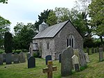 More images |
| Church (consecration Unknown) | Langtree, Torridge | Parish Church | 15th century to the early 16th century | 4 October 1960 | SS4510915575 50°55′08″N 4°12′18″W / 50.918791°N 4.204954°W / 50.918791; -4.204954 (Church (consecration Unknown)) | 1104560 |  More images |
| Chapel of St Mary Magdalene | Taddiport, Little Torrington, Torridge | Chapel | 13th century | 4 October 1960 | SS4877618664 50°56′51″N 4°09′15″W / 50.947522°N 4.154107°W / 50.947522; -4.154107 (Chapel of St Mary Magdalene) | 1147254 |  More images |
| Church of St Giles | Little Torrington, Little Torrington, Torridge | Parish Church | 15th century | 16 February 1989 | SS4910116851 50°55′53″N 4°08′55″W / 50.931316°N 4.148733°W / 50.931316; -4.148733 (Church of St Giles) | 1105026 |  More images |
| Cross House | Little Torrington, Torridge | Country House | 1680-85 | 4 October 1960 | SS4873617532 50°56′14″N 4°09′15″W / 50.937339°N 4.154206°W / 50.937339; -4.154206 (Cross House) | 1105022 | 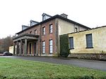 More images |
| South Hole Farmhouse | Little Torrington, Torridge | Farmhouse | Early 17th century | 16 February 1989 | SS5047215825 50°55′21″N 4°07′44″W / 50.922453°N 4.128816°W / 50.922453; -4.128816 (South Hole Farmhouse) | 1105024 | Upload Photo |
| Woodland Farmhouse | Little Torrington, Torridge | Farmhouse | Second half of the 15th century | 4 October 1960 | SS5039716854 50°55′54″N 4°07′49″W / 50.931681°N 4.130305°W / 50.931681; -4.130305 (Woodland Farmhouse) | 1326584 | Upload Photo |
| Church of All Saints | Merton, Merton, Torridge | Parish Church | 14th century | 4 October 1960 | SS5257412031 50°53′20″N 4°05′51″W / 50.8889°N 4.097398°W / 50.8889; -4.097398 (Church of All Saints) | 1326588 | 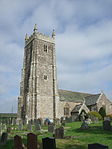 More images |
| Downes House | Merton, Merton, Torridge | Farmhouse | Early-Mid 17th century | 4 October 1960 | SS5295612312 50°53′29″N 4°05′32″W / 50.891523°N 4.092084°W / 50.891523; -4.092084 (Downes House) | 1147488 | Upload Photo |
| Garden Wall Extending to South of Great Potheridge | Great Potheridge, Merton, Torridge | Garden Wall | 1660-70 | 16 February 1989 | SS5139114622 50°54′43″N 4°06′55″W / 50.91188°N 4.11526°W / 50.91188; -4.11526 (Garden Wall Extending to South of Great Potheridge) | 1105033 | Upload Photo |
| Church of Holy Trinity | Milton Damerel, Milton Damerel, Torridge | Sundial | 1808 | 14 February 1958 | SS3845010717 50°52′24″N 4°17′51″W / 50.873314°N 4.29746°W / 50.873314; -4.29746 (Church of Holy Trinity) | 1162778 |  More images |
| Church of St Petrock | Newton St Petrock, Newton St. Petrock, Torridge | Sundial | dated 1723 | 26 January 1989 | SS4113012236 50°53′16″N 4°15′36″W / 50.887706°N 4.260062°W / 50.887706; -4.260062 (Church of St Petrock) | 1105096 | 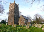 More images |
| Diddywell | Northam, Northam, Torridge | Farmhouse | Formerly | 15 June 1951 | SS4544329832 51°02′49″N 4°12′23″W / 51.046989°N 4.206273°W / 51.046989; -4.206273 (Diddywell) | 1306534 | Upload Photo |
| Docton House | Appledore, Northam, Torridge | House | circa late 16th century or early 17th century | 15 June 1951 | SS4643730350 51°03′07″N 4°11′32″W / 51.05191°N 4.192324°W / 51.05191; -4.192324 (Docton House) | 1333011 | Upload Photo |
| Orchard Hill House | Northam, Northam, Torridge | House | late 18th century or early 19th century | 19 February 1973 | SS4532527644 51°01′38″N 4°12′25″W / 51.027296°N 4.207021°W / 51.027296; -4.207021 (Orchard Hill House) | 1267190 | Upload Photo |
| Porthill | Northam, Northam, Torridge | House | 1760 | 19 February 1973 | SS4480428400 51°02′02″N 4°12′53″W / 51.033949°N 4.214768°W / 51.033949; -4.214768 (Porthill) | 1306519 | Upload Photo |
| Richmond Dock | Appledore, Northam, Torridge | Dry Dock | 1856 | 12 February 1987 | SS4647130324 51°03′06″N 4°11′31″W / 51.051685°N 4.191828°W / 51.051685; -4.191828 (Richmond Dock) | 1140140 | 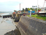 |
| Church of St Pancras | Village Centre, Pancrasweek, Torridge | Anglican Church | 1894-8 | 14 February 1958 | SS2968305821 50°49′37″N 4°25′11″W / 50.826808°N 4.41967°W / 50.826808; -4.41967 (Church of St Pancras) | 1164477 | 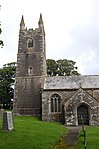 More images |
| Church of St James | Parkham, Torridge | Sundial | 1731 | 20 February 1958 | SS3890221509 50°58′13″N 4°17′45″W / 50.970408°N 4.295811°W / 50.970408; -4.295811 (Church of St James) | 1326557 |  More images |
| Church of St Petrock | Petrockstowe, Petrockstow, Torridge | Parish Church | Norman | 4 October 1960 | SS5131909162 50°51′46″N 4°06′51″W / 50.862797°N 4.114061°W / 50.862797; -4.114061 (Church of St Petrock) | 1333084 |  More images |
| Little Marland | Petrockstow, Torridge | Farmhouse | Circa 1500-1525 | 4 October 1960 | SS4992311958 50°53′15″N 4°08′06″W / 50.887561°N 4.135031°W / 50.887561; -4.135031 (Little Marland) | 1104530 | Upload Photo |
| Church of St Swithin | Village Centre, Pyworthy, Torridge | Anglican Church | 1885 | 14 February 1958 | SS3129202881 50°48′03″N 4°23′44″W / 50.800865°N 4.395493°W / 50.800865; -4.395493 (Church of St Swithin) | 1164560 |  More images |
| Church of Saint Peter | Roborough, Roborough, Torridge | Parish Church | C13/C14 | 4 October 1960 | SS5769217120 50°56′09″N 4°01′36″W / 50.935918°N 4.026669°W / 50.935918; -4.026669 (Church of Saint Peter) | 1326612 | 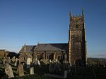 More images |
| Coombe Barton and Adjoining Front Garden Walls | Coombe Barton, Roborough, Torridge | Farmhouse | Late C16/Early 17th century | 16 January 1952 | SS5673417983 50°56′36″N 4°02′26″W / 50.943436°N 4.040633°W / 50.943436; -4.040633 (Coombe Barton and Adjoining Front Garden Walls) | 1105040 | Upload Photo |
| Ebberly House | Ebberly, Roborough, Torridge | House | Before c1816 | 16 January 1952 | SS5647318549 50°56′54″N 4°02′40″W / 50.948458°N 4.044569°W / 50.948458; -4.044569 (Ebberly House) | 1105001 |  More images |
| Great Barlington Farmhouse and Adjoining Front Garden Walls | Great Barlington, Roborough, Torridge | Farmhouse | Early 18th century | 16 February 1989 | SS5667316459 50°55′47″N 4°02′27″W / 50.929726°N 4.040901°W / 50.929726; -4.040901 (Great Barlington Farmhouse and Adjoining Front Garden Walls) | 1326611 | Upload Photo |
| Church of St Michael | Shebbear, Shebbear, Torridge | Parish Church | Norman | 4 October 1960 | SS4384509228 50°51′41″N 4°13′13″W / 50.861418°N 4.220208°W / 50.861418; -4.220208 (Church of St Michael) | 1309558 |  More images |
| Church of St Lawrence | Sheepwash, Sheepwash, Torridge | Parish Church | earlier building | 4 October 1960 | SS4869606328 50°50′12″N 4°09′00″W / 50.836649°N 4.150133°W / 50.836649; -4.150133 (Church of St Lawrence) | 1104503 |  More images |
| The Library | Stevenstone Park, St. Giles in the Wood, Torridge | Library | Late C17-Early 18th century | 4 October 1960 | SS5268419337 50°57′16″N 4°05′56″W / 50.954583°N 4.098788°W / 50.954583; -4.098788 (The Library) | 1104996 | 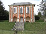 More images |
| The Orangery | Stevenstone Park, St. Giles in the Wood, Torridge | Orangery | c. 1720 | 4 October 1960 | SS5269619380 50°57′18″N 4°05′55″W / 50.954972°N 4.098635°W / 50.954972; -4.098635 (The Orangery) | 1168092 | 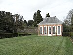 More images |
| Church of St Giles | St Giles on the Heath, St. Giles on the Heath, Torridge | Parish Church | 13th century | 23 August 1957 | SX3536790756 50°41′35″N 4°19′56″W / 50.693093°N 4.332294°W / 50.693093; -4.332294 (Church of St Giles) | 1333042 |  More images |
| Nether Bridge | St. Giles on the Heath, Torridge | Milestone | Medieval | 9 January 1986 | SX3485686736 50°39′25″N 4°20′16″W / 50.656827°N 4.337727°W / 50.656827; -4.337727 (Nether Bridge) | 1104690 | Upload Photo |
| Church of St Andrew | Sutcombe, Sutcombe, Torridge | Obelisk | 1742 | 14 February 1958 | SS3469711666 50°52′51″N 4°21′04″W / 50.880779°N 4.351182°W / 50.880779; -4.351182 (Church of St Andrew) | 1326580 |  More images |
| Manor Cottage Tetcott Barton Tetcott Manor | Tetcott, Tetcott, Torridge | Cross Passage House | 16th century | 4 December 1951 | SX3315896575 50°44′41″N 4°21′58″W / 50.744746°N 4.366175°W / 50.744746; -4.366175 (Manor Cottage Tetcott Barton Tetcott Manor) | 1262341 | Upload Photo |
| Church of St Peter | Thornbury, Thornbury, Torridge | Parish Church | Norman origins | 14 February 1958 | SS4006208455 50°51′12″N 4°16′25″W / 50.853438°N 4.273579°W / 50.853438; -4.273579 (Church of St Peter) | 1162910 |  More images |
| Church of St Nectan | Welcombe, Welcombe, Torridge | Anglican Church | 1508 | 20 February 1958 | SS2281018434 50°56′17″N 4°31′24″W / 50.938056°N 4.523277°W / 50.938056; -4.523277 (Church of St Nectan) | 1333126 |  More images |
| Cory Manor | Village Centre, West Putford, Torridge | Manor House | Late C16-Early 17th century | 14 February 1958 | SS3598715752 50°55′04″N 4°20′05″W / 50.917859°N 4.334698°W / 50.917859; -4.334698 (Cory Manor) | 1104954 | Upload Photo |
| Lower Bransgrove | Winkleigh, Torridge | Farmhouse | Probably 14th century | 18 June 1991 | SS6580010770 50°52′51″N 3°54′32″W / 50.880794°N 3.909011°W / 50.880794; -3.909011 (Lower Bransgrove) | 1104575 | Upload Photo |
| Parish Church of St Andrew | Yarnscombe, Yarnscombe, Torridge | Parish Church | 13th century | 4 October 1960 | SS5616323600 50°59′38″N 4°03′04″W / 50.993771°N 4.050978°W / 50.993771; -4.050978 (Parish Church of St Andrew) | 1104961 |  More images |
| Lightkeeper's House Old Lighthouse | Torridge | Lighthouse | 1787 | 7 October 1991 | SS1320444290 51°10′02″N 4°40′23″W / 51.167272°N 4.673191°W / 51.167272; -4.673191 (Lightkeeper's House Old Lighthouse) | 1326646 |  More images |
| Marisco Castle, Keep and Bailey Walls | Torridge | Bailey | 1243 | 7 October 1991 | SS1414643772 51°09′47″N 4°39′34″W / 51.162926°N 4.659465°W / 51.162926; -4.659465 (Marisco Castle, Keep and Bailey Walls) | 1104957 | 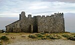 More images |
Notes
- ^ The date given is the date used by Historic England as significant for the initial building or that of an important part in the structure's description.
- ^ Sometimes known as OSGB36, the grid reference is based on the British national grid reference system used by the Ordnance Survey.
- ^ The "List Entry Number" is a unique number assigned to each listed building and scheduled monument by Historic England.
External links
- v
- t
- e
- Bedfordshire
- Berkshire
- Bristol
- Buckinghamshire
- Cambridgeshire
- Cheshire
- Cornwall
- Cumbria
- Derbyshire
- Devon
- Dorset
- Durham
- East Sussex
- East Riding of Yorkshire
- Essex
- Gloucestershire
- Greater London
- Greater Manchester
- Hampshire
- Herefordshire
- Hertfordshire
- Isle of Wight
- Kent
- Lancashire
- Leicestershire
- Lincolnshire
- Merseyside
- Norfolk
- North Yorkshire
- Northamptonshire
- Northumberland
- Nottinghamshire
- Oxfordshire
- Rutland
- Shropshire
- Somerset
- South Yorkshire
- Staffordshire
- Suffolk
- Surrey
- Tyne and Wear
- Warwickshire
- West Midlands
- West Sussex
- West Yorkshire
- Wiltshire
- Worcestershire
- Allerdale
- Amber Valley
- Ashford
- Babergh
- Barrow-in-Furness
- Basildon
- Basingstoke and Deane
- Bath and North East Somerset
- Bolsover
- Boston
- Bournemouth
- Bradford
- Braintree
- Breckland
- Brentwood
- Brighton and Hove
- Bristol
- Broadland
- Calderdale
- Cambridge
- Camden
- Canterbury
- Carlisle
- Castle Point
- Chelmsford
- Cheltenham
- Cherwell
- Cheshire East
- Cheshire West and Chester
- Chesterfield
- Chiltern
- Christchurch
- Colchester
- Copeland
- Corby
- Cotswold
- Craven
- Dartford
- Daventry
- Dover
- East Cambridgeshire
- Exeter
- Mendip
- North Somerset
- Poole
- Sedgemoor
- South Somerset
- Stoke-on-Trent
- Taunton Deane
- West Somerset
- York


