Grade II* listed buildings in Watford
Map all coordinates using OpenStreetMap
Download coordinates as:
- KML
- GPX (all coordinates)
- GPX (primary coordinates)
- GPX (secondary coordinates)
There are over 20,000 Grade II* listed buildings in England. This page is a list of these buildings in the district of Watford in Hertfordshire.
Watford
| Name | Location | Type | Completed [note 1] | Date designated | Grid ref.[note 2] Geo-coordinates | Entry number [note 3] | Image |
|---|---|---|---|---|---|---|---|
| Frogmore House | Watford | House | 1716 | 26 August 1952 | TQ1168495761 51°38′58″N 0°23′14″W / 51.64956°N 0.387123°W / 51.64956; -0.387123 (Frogmore House) | 1175515 |  Upload Photo |
| Little Cassiobury and Former Stable Block to Rear | Watford | House | Late 17th century | 26 August 1952 | TQ1035596970 51°39′38″N 0°24′21″W / 51.660688°N 0.405943°W / 51.660688; -0.405943 (Little Cassiobury and Former Stable Block to Rear) | 1175392 | 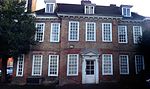 More images |
| The Mrs Elizabeth Fuller Free School | Watford | Free School | 1704 | 26 August 1952 | TQ1107396230 51°39′14″N 0°23′45″W / 51.653896°N 0.395802°W / 51.653896; -0.395802 (The Mrs Elizabeth Fuller Free School) | 1348086 | 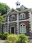 More images |
| Watford Peace Memorial | The Parade, Watford | War memorial | 1928 | 7 January 1983 | TQ1052996890 51°39′36″N 0°24′12″W / 51.659935°N 0.40345361°W / 51.659935; -0.40345361 (Watford Peace Memorial) | 1348116 |  More images |
Notes
- ^ The date given is the date used by Historic England as significant for the initial building or that of an important part in the structure's description.
- ^ Sometimes known as OSGB36, the grid reference is based on the British national grid reference system used by the Ordnance Survey.
- ^ The "List Entry Number" is a unique number assigned to each listed building and scheduled monument by Historic England.
External links
- v
- t
- e
Listed buildings in Hertfordshire
| |||||||||||||||||||||
Grade II | |||||||||||||||||||||
|---|---|---|---|---|---|---|---|---|---|---|---|---|---|---|---|---|---|---|---|---|---|
| |||||||||||||||||||||


