Grade I listed buildings in West Yorkshire

Map all coordinates using OpenStreetMap
Download coordinates as:
- KML
- GPX (all coordinates)
- GPX (primary coordinates)
- GPX (secondary coordinates)
There are over 9,000 Grade I listed buildings in England. This page is a list of these buildings in the county of West Yorkshire, by metropolitan district.
Bradford
| Name | Location | Type | Completed [note 1] | Date designated | Grid ref.[note 2] Geo-coordinates | Entry number [note 3] | Image |
|---|---|---|---|---|---|---|---|
| Heathcote | Ilkley | House | 1906–08 | 12 December 2014 | SE1085747608 53°55′28″N 1°50′10″W / 53.924495°N 1.83616°W / 53.924495; -1.83616 (Heathcote) | 1133518 |  More images |
| 2 Pairs of Gate Piers and Linking Walls with Summer-house Attached to Rear of Farfield Hall | Addingham, Ilkley | Gate Pier | Early 18th century | 10 September 1954 | SE0773651653 53°57′39″N 1°53′01″W / 53.960906°N 1.883584°W / 53.960906; -1.883584 (2 Pairs of Gate Piers and Linking Walls with Summer-house Attached to Rear of Farfield Hall) | 1133451 |  Upload Photo |
| Church of St Peter | Addingham, Ilkley | Cross | Anglo-Saxon | 10 September 1954 | SE0852249696 53°56′36″N 1°52′18″W / 53.943305°N 1.871659°W / 53.943305; -1.871659 (Church of St Peter) | 1133457 |  More images |
| Farfield Hall | Addingham, Ilkley | Kitchen | 16th century or 17th century | 10 September 1954 | SE0773951619 53°57′38″N 1°53′01″W / 53.9606°N 1.883539°W / 53.9606; -1.883539 (Farfield Hall) | 1133450 |  More images |
| Bingley Five Rise Locks with Overflow Channel | Bingley | Steps | c. 1773 | 9 August 1966 | SE1075839959 53°51′21″N 1°50′17″W / 53.85575°N 1.837933°W / 53.85575; -1.837933 (Bingley Five Rise Locks with Overflow Channel) | 1314303 |  More images |
| Burley House | Burley in Wharfedale, Ilkley | Country House | Late 18th century | 18 July 1949 | SE1702746105 53°54′39″N 1°44′32″W / 53.910822°N 1.742289°W / 53.910822; -1.742289 (Burley House) | 1199636 |  More images |
| Haworth Parsonage (Brontë Museum) | Haworth | Vicarage | 1779 | 23 February 1955 | SE0290937214 53°49′52″N 1°57′26″W / 53.83118°N 1.957284°W / 53.83118; -1.957284 (Haworth Parsonage (Brontë Museum)) | 1313933 |  More images |
| 3 Stone Crosses previously south of the Church of All Saints, now inside | Ilkley | Cross | Early C9 | 20 May 1976 | SE1164847813 53°55′35″N 1°49′27″W / 53.926321°N 1.824107°W / 53.926321; -1.824107 (3 Stone Crosses previously south of the Church of All Saints, now inside) | 1133507 |  More images |
| Manor House | Ilkley | House | Earlier than 16th century | 18 July 1949 | SE1160647869 53°55′37″N 1°49′29″W / 53.926825°N 1.824745°W / 53.926825; -1.824745 (Manor House) | 1133505 |  More images |
| Myddelton Lodge (St Paul's Retreat) | Ilkley | Detached House | 16th century | 18 July 1949 | SE1099549064 53°56′15″N 1°50′02″W / 53.937578°N 1.834007°W / 53.937578; -1.834007 (Myddelton Lodge (St Paul's Retreat)) | 1133521 | 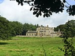 More images |
| East Riddlesden Hall | Riddlesden, Keighley | House | Pre 1640 | 23 February 1955 | SE0789342064 53°52′29″N 1°52′53″W / 53.87472°N 1.881435°W / 53.87472; -1.881435 (East Riddlesden Hall) | 1283478 |  More images |
| West Riddlesden Hall | Riddlesden, Keighley | House | 1687 | 23 February 1955 | SE0727042690 53°52′49″N 1°53′27″W / 53.880355°N 1.890896°W / 53.880355; -1.890896 (West Riddlesden Hall) | 1313939 | Upload Photo |
| Bolling Hall (museum) | Bowling | Hall House | 14th century Probably | 4 September 1952 | SE1730631431 53°46′44″N 1°44′20″W / 53.778926°N 1.738863°W / 53.778926; -1.738863 (Bolling Hall (museum)) | 1299398 |  More images |
| Bradford City Hall | Bradford city centre | Town Hall | 1869-1873 | 14 June 1963 | SE1635132912 53°47′32″N 1°45′12″W / 53.792268°N 1.753277°W / 53.792268; -1.753277 (Bradford City Hall) | 1133675 |  More images |
| Cathedral Church of St Peter | Bradford city centre | Cathedral | 1919 | 4 September 1952 | SE1671533264 53°47′44″N 1°44′52″W / 53.79542°N 1.747733°W / 53.79542; -1.747733 (Cathedral Church of St Peter) | 1133250 | 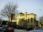 More images |
| The Wool Exchange | Bradford city centre | Wool Exchange | 1864 to 1867 | 14 June 1963 | SE1640233128 53°47′39″N 1°45′09″W / 53.794207°N 1.752492°W / 53.794207; -1.752492 (The Wool Exchange) | 1132985 | 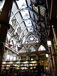 More images |
| Congregational Church (including Salt Family Mausoleum to South) | Saltaire, Shipley | Bust | 1858-9 | 22 November 1966 | SE1385838107 53°50′21″N 1°47′27″W / 53.839031°N 1.790888°W / 53.839031; -1.790888 (Congregational Church (including Salt Family Mausoleum to South)) | 1314229 | 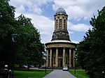 More images |
| Upper Headley Hall | Thornton | House | 1589 | 4 September 1952 | SE0978532157 53°47′08″N 1°51′11″W / 53.785645°N 1.852971°W / 53.785645; -1.852971 (Upper Headley Hall) | 1111890 |  More images |
| Courtyard Entrance and Walling at Upper Headley Hall | Thornton | Gate | Dated 1669 | 4 September 1952 | SE0979032141 53°47′08″N 1°51′10″W / 53.785501°N 1.852895°W / 53.785501; -1.852895 (Courtyard Entrance and Walling at Upper Headley Hall) | 1133129 |  |
| Barn at Upper Headley Hall | Thornton | Barn | Late 16th century or early 17th century | 4 September 1952 | SE0976332171 53°47′09″N 1°51′12″W / 53.785771°N 1.853304°W / 53.785771; -1.853304 (Barn at Upper Headley Hall) | 1133130 | Upload Photo |
| Tong Hall | Tong | House | C15/C16 | 4 September 1952 | SE2180930710 53°46′20″N 1°40′14″W / 53.772278°N 1.670583°W / 53.772278; -1.670583 (Tong Hall) | 1314140 |  More images |
| Church of St James | Tong | Church | Medieval | 4 September 1952 | SE2191730542 53°46′15″N 1°40′08″W / 53.770763°N 1.668956°W / 53.770763; -1.668956 (Church of St James) | 1133660 |  More images |
Calderdale
| Name | Location | Type | Completed [note 1] | Date designated | Grid ref.[note 2] Geo-coordinates | Entry number [note 3] | Image |
|---|---|---|---|---|---|---|---|
| Barkisland Hall | Barkisland, Ripponden | House | 1638 | 15 August 1966 | SE0607019934 53°40′33″N 1°54′35″W / 53.67584°N 1.90959°W / 53.67584; -1.90959 (Barkisland Hall) | 1276881 |  More images |
| The Howroyde | Barkisland, Ripponden | House | Mid 18th century | 15 August 1966 | SE0583719470 53°40′18″N 1°54′47″W / 53.671672°N 1.913125°W / 53.671672; -1.913125 (The Howroyde) | 1277316 |  More images |
| The Unitarian Church | Todmorden | Unitarian Chapel | 1865-1869 | 22 November 1966 | SD9356423861 53°42′40″N 2°05′56″W / 53.711129°N 2.098986°W / 53.711129; -2.098986 (The Unitarian Church) | 1228988 |  More images |
| Todmorden Town Hall | Todmorden | Court House | Early 1860s | 22 November 1966 | SD9366524167 53°42′50″N 2°05′51″W / 53.713881°N 2.097462°W / 53.713881; -2.097462 (Todmorden Town Hall) | 1228980 |  More images |
| Church of All Souls | Boothtown, Halifax | Church | 1856 | 3 November 1954 | SE0915326022 53°43′50″N 1°51′46″W / 53.730515°N 1.862742°W / 53.730515; -1.862742 (Church of All Souls) | 1314027 |  More images |
| Church of St John the Baptist | Halifax | Church | 12th-century origins | 3 November 1954 | SE0974525209 53°43′24″N 1°51′14″W / 53.723197°N 1.853794°W / 53.723197; -1.853794 (Church of St John the Baptist) | 1133928 |  More images |
| Church of St Mary | Elland | Gate | 19th century | 24 January 1968 | SE1080521159 53°41′12″N 1°50′16″W / 53.686775°N 1.83787°W / 53.686775; -1.83787 (Church of St Mary) | 1184393 |  More images |
| Church of St Peter | Sowerby | Church | Earlier | 15 November 1966 | SE0428823201 53°42′19″N 1°56′11″W / 53.705222°N 1.936521°W / 53.705222; -1.936521 (Church of St Peter) | 1313775 |  More images |
| Double Aisled Barn to North West of Kirklees Priory Gatehouse | Kirklees Park | Barn | 15th century | 3 January 1967 | SE1742722122 53°41′43″N 1°44′15″W / 53.695253°N 1.737548°W / 53.695253; -1.737548 (Double Aisled Barn to North West of Kirklees Priory Gatehouse) | 1133848 |  |
| Home Farm Building Number 9 Malthouse | Kirklees Park | Malt House | Late 17th century | 3 January 1967 | SE1732722246 53°41′47″N 1°44′21″W / 53.696371°N 1.739056°W / 53.696371; -1.739056 (Home Farm Building Number 9 Malthouse) | 1133809 |  More images |
| Kirklees Hall Mansion and Attached Stables | Kirklees Park | Country House | Mid 16th century | 3 January 1967 | SE1703422237 53°41′47″N 1°44′37″W / 53.6963°N 1.743494°W / 53.6963; -1.743494 (Kirklees Hall Mansion and Attached Stables) | 1184034 |  More images |
| Kershaw House | Luddenden Foot | Cross Wing House/Restaurant | Early-Mid 17th century | 15 November 1966 | SE0398425462 53°43′32″N 1°56′28″W / 53.725546°N 1.941098°W / 53.725546; -1.941098 (Kershaw House) | 1184572 |  More images |
| New Hall | Elland | House | 17th century | 24 January 1968 | SE1190920974 53°41′06″N 1°49′16″W / 53.685089°N 1.821161°W / 53.685089; -1.821161 (New Hall) | 1313979 |  More images |
| Piece Hall | Halifax town centre | Market Hall | Converted 1868 | 3 November 1954 | SE0955925077 53°43′19″N 1°51′24″W / 53.722014°N 1.856617°W / 53.722014; -1.856617 (Piece Hall) | 1273056 | 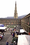 More images |
| High Bentley | Shelf | House | 17th century | 1 November 1956 | SE1312728517 53°45′10″N 1°48′09″W / 53.752856°N 1.802402°W / 53.752856; -1.802402 (High Bentley) | 1133765 | Upload Photo |
| Wood Lane Hall | Sowerby | House | 1649 | 19 July 1988 | SE0433723651 53°42′33″N 1°56′09″W / 53.709266°N 1.935773°W / 53.709266; -1.935773 (Wood Lane Hall) | 1134490 |  More images |
Kirklees
| Name | Location | Type | Completed [note 1] | Date designated | Grid ref.[note 2] Geo-coordinates | Entry number [note 3] | Image |
|---|---|---|---|---|---|---|---|
| Church of St Michael | Emley | Church | Early Medieval | 29 March 1965 | SE2449413320 53°36′57″N 1°37′52″W / 53.615859°N 1.631213°W / 53.615859; -1.631213 (Church of St Michael) | 1135290 |  More images |
| Church of All Hallows | Kirkburton | Church | c. 1200 | 23 June 1965 | SE1980212497 53°36′31″N 1°42′08″W / 53.608659°N 1.70219°W / 53.608659; -1.70219 (Church of All Hallows) | 1313318 | 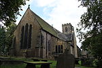 More images |
| Woodsome Hall | Fenay Bridge, Huddersfield[1] | House | ? | 23 June 1965 | SE1802614414 53°37′33″N 1°43′44″W / 53.625953°N 1.728921°W / 53.625953; -1.728921 (Woodsome Hall) | 1184158 |  More images |
| Banney Royd | Edgerton, Huddersfield | House | 1900-1 | 29 September 1978 | SE1260018100 53°39′33″N 1°48′39″W / 53.659241°N 1.810814°W / 53.659241; -1.810814 (Banney Royd) | 1134184 | Upload Photo |
| Church of All Hallows | Almondbury | Church | 13th century | 3 March 1952 | SE1683315058 53°37′54″N 1°44′49″W / 53.631781°N 1.746925°W / 53.631781; -1.746925 (Church of All Hallows) | 1225096 |  More images |
| Church of All Saints | Batley | Church | 13th century | 29 March 1963 | SE2413024457 53°42′58″N 1°38′09″W / 53.715975°N 1.635854°W / 53.715975; -1.635854 (Church of All Saints) | 1134620 |  More images |
| Church of St Michael and All Angels | Thornhill | Church | 15th century | 30 June 1949 | SE2533718862 53°39′56″N 1°37′05″W / 53.66563°N 1.618021°W / 53.66563; -1.618021 (Church of St Michael and All Angels) | 1200754 |  More images |
| Oakwell Hall Including Boundary Wall | Birstall | Hall House | 1583 | 29 March 1963 | SE2174627114 53°44′24″N 1°40′18″W / 53.73996°N 1.67179°W / 53.73996; -1.67179 (Oakwell Hall Including Boundary Wall) | 1134609 |  More images |
| Huddersfield railway station | Huddersfield town centre | Gate | 1846-50 | 3 March 1952 | SE1431316909 53°38′55″N 1°47′06″W / 53.648492°N 1.784947°W / 53.648492; -1.784947 (Huddersfield railway station) | 1277385 |  More images |
| Lees Hall | Thornhill Lees, Dewsbury | House | 1530 | 30 June 1949 | SE2330919992 53°40′33″N 1°38′55″W / 53.675881°N 1.648628°W / 53.675881; -1.648628 (Lees Hall) | 1313642 |  More images |
Leeds
| Name | Location | Type | Completed [note 1] | Date designated | Grid ref.[note 2] Geo-coordinates | Entry number [note 3] | Image |
|---|---|---|---|---|---|---|---|
| Church of All Hallows | Bardsey | Parish Church | 850-950 | 30 March 1966 | SE3656143123 53°52′59″N 1°26′43″W / 53.883016°N 1.445296°W / 53.883016; -1.445296 (Church of All Hallows) | 1135652 |  More images |
| Open Temple at West End of Quarter Mile Walk in Bramham Park | Bramham Park, Bramham | Garden Temple | Early 18th century | 30 March 1966 | SE4046341351 53°52′00″N 1°23′10″W / 53.866802°N 1.386173°W / 53.866802; -1.386173 (Open Temple at West End of Quarter Mile Walk in Bramham Park) | 1313176 | 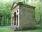 |
| Retaining Wall to South Terrace and Eastern Part of Garden Terminating at the Four Faces Avenue | Bramham Park, Bramham | Garden Wall | 1727-28 | 22 July 1986 | SE4061341155 53°51′54″N 1°23′02″W / 53.865028°N 1.383918°W / 53.865028; -1.383918 (Retaining Wall to South Terrace and Eastern Part of Garden Terminating at the Four Faces Avenue) | 1066000 | Upload Photo |
| Stone Surround to T-shaped Pond | Bramham Park, Bramham | Garden Wall | 1728 | 2 September 1952 | SE4063641202 53°51′56″N 1°23′01″W / 53.865449°N 1.383562°W / 53.865449; -1.383562 (Stone Surround to T-shaped Pond) | 1135662 | Upload Photo |
| The Rotunda in the Black Fen Pleasure Ground | Bramham Park, Bramham | Garden Temple | Mid 18th century | 1 May 1960 | SE4136040835 53°51′44″N 1°22′21″W / 53.862094°N 1.372602°W / 53.862094; -1.372602 (The Rotunda in the Black Fen Pleasure Ground) | 1066002 |  More images |
| Bramham Park | Bramham Park, Bramham | Country House | 1700-10 | 2 September 1952 | SE4084641724 53°52′12″N 1°22′49″W / 53.870124°N 1.380299°W / 53.870124; -1.380299 (Bramham Park) | 1135635 |  More images |
| Chapel at North End of Terrace to Rear of Bramham Park | Bramham Park, Bramham | Summerhouse/Watertower | 1750-62 | 30 March 1966 | SE4077541810 53°52′15″N 1°22′53″W / 53.870902°N 1.381368°W / 53.870902; -1.381368 (Chapel at North End of Terrace to Rear of Bramham Park) | 1135640 |  More images |
| Gatepiers at Entrance to Forecourt of Bramham Park with Attached Retaining Wall | Bramham Park, Bramham | Gate | Early 18th century | 30 March 1966 | SE4093941778 53°52′14″N 1°22′44″W / 53.870602°N 1.378878°W / 53.870602; -1.378878 (Gatepiers at Entrance to Forecourt of Bramham Park with Attached Retaining Wall) | 1135636 | Upload Photo |
| Gothic Temple Approximately 370 Metres South of Bramham Park House | Bramham Park, Bramham | Garden Temple | 18th century | 2 September 1952 | SE4080141343 53°52′00″N 1°22′52″W / 53.866703°N 1.381034°W / 53.866703; -1.381034 (Gothic Temple Approximately 370 Metres South of Bramham Park House) | 1200485 |  More images |
| Obelisk Pond and the Great Cascade Approximately 300 Metres South of Bramham Park House | Bramham Park, Bramham | Garden Pool | 1724-5 | 30 March 1966 | SE4099441492 53°52′05″N 1°22′41″W / 53.868027°N 1.37808°W / 53.868027; -1.37808 (Obelisk Pond and the Great Cascade Approximately 300 Metres South of Bramham Park House) | 1300743 |  |
| Parterre to West of Bramham Park House with 2 Pillars and 6 Urns | Bramham Park, Bramham | Terrace | Early 18th century | 3 December 1986 | SE4078641711 53°52′12″N 1°22′52″W / 53.870012°N 1.381213°W / 53.870012; -1.381213 (Parterre to West of Bramham Park House with 2 Pillars and 6 Urns) | 1135639 | Upload Photo |
| Stable Block Forming South Side of Forecourt to Bramham Park | Bramham Park, Bramham | House | Early 18th century | 30 March 1966 | SE4092441724 53°52′12″N 1°22′45″W / 53.870118°N 1.379113°W / 53.870118; -1.379113 (Stable Block Forming South Side of Forecourt to Bramham Park) | 1135638 |  |
| T Pond at Junction of Walks Approximately 350 Metres South West of Bramham Park House | Bramham Park, Bramham | Formal Garden | 1728 | 30 March 1966 | SE4066241414 53°52′02″N 1°22′59″W / 53.867352°N 1.383138°W / 53.867352; -1.383138 (T Pond at Junction of Walks Approximately 350 Metres South West of Bramham Park House) | 1135642 | Upload Photo |
| Puritan Chapel | Bramhope | Nonconformist Chapel | 1649 | 22 November 1966 | SE2490543592 53°53′17″N 1°37′21″W / 53.887919°N 1.622571°W / 53.887919; -1.622571 (Puritan Chapel) | 1261799 |  More images |
| Lumb Hall | Drighlington | Clothiers House | c. 1640 | 7 August 1964 | SE2270829359 53°45′36″N 1°39′25″W / 53.760097°N 1.657042°W / 53.760097; -1.657042 (Lumb Hall) | 1135127 |  More images |
| Church of All Saints | Harewood Park, Harewood | Church | 1775 | 30 March 1966 | SE3137345003 53°54′01″N 1°31′26″W / 53.900251°N 1.524024°W / 53.900251; -1.524024 (Church of All Saints) | 1266157 |  More images |
| Harewood Castle | Harewood Park, Harewood | Castle | Mid 14th century | 30 March 1966 | SE3217845622 53°54′21″N 1°30′42″W / 53.905765°N 1.511708°W / 53.905765; -1.511708 (Harewood Castle) | 1226242 |  More images |
| Harewood House | Harewood Park, Harewood | Country House | 1759-71 | 30 March 1960 | SE3116044628 53°53′49″N 1°31′38″W / 53.896894°N 1.527303°W / 53.896894; -1.527303 (Harewood House) | 1225861 |  More images |
| Stables Approximately 200 Metres to South West of Harewood House | Harewood Park, Harewood | Stables | 1755-58 | 30 March 1966 | SE3109644401 53°53′41″N 1°31′42″W / 53.894857°N 1.5283°W / 53.894857; -1.5283 (Stables Approximately 200 Metres to South West of Harewood House) | 1266160 |  More images |
| Church of St Mary | Kippax | Church | Anglo Saxon | 15 September 1987 | SE4168430329 53°46′04″N 1°22′09″W / 53.767646°N 1.369095°W / 53.767646; -1.369095 (Church of St Mary) | 1237399 |  More images |
| Church of All Saints | Ledsham | Church | Saxon | 3 February 1967 | SE4565029774 53°45′44″N 1°18′32″W / 53.762327°N 1.309014°W / 53.762327; -1.309014 (Church of All Saints) | 1237404 |  More images |
| Ledston Lodge | Ledston Park, Ledsham | House | 17th century | 3 February 1967 | SE4501230906 53°46′21″N 1°19′07″W / 53.772556°N 1.318526°W / 53.772556; -1.318526 (Ledston Lodge) | 1264072 |  More images |
| Barn Forming East Side of Stable Yard Approximately 100 Metres East of Ledston Hall | Ledston | Barn | 17th century | 4 July 1952 | SE4366528907 53°45′17″N 1°20′21″W / 53.754704°N 1.339244°W / 53.754704; -1.339244 (Barn Forming East Side of Stable Yard Approximately 100 Metres East of Ledston Hall) | 1237515 | Upload Photo |
| Entrance Gates and Lodges | Ledston | Gate Lodge | Early 18th century | 4 July 1952 | SE4358528887 53°45′16″N 1°20′26″W / 53.754531°N 1.34046°W / 53.754531; -1.34046 (Entrance Gates and Lodges) | 1264075 | Upload Photo |
| Ledston Hall | Ledston | Country House | c. 1200 | 4 July 1952 | SE4354628933 53°45′18″N 1°20′28″W / 53.754948°N 1.341045°W / 53.754948; -1.341045 (Ledston Hall) | 1237569 | 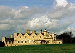 More images |
| Stable Block Approximately 50 Metres East of Ledston Hall | Ledston | Stables | 17th century | 4 July 1952 | SE4362928920 53°45′17″N 1°20′23″W / 53.754824°N 1.339789°W / 53.754824; -1.339789 (Stable Block Approximately 50 Metres East of Ledston Hall) | 1247674 | Upload Photo |
| The Town Hall | Morley town centre | Town Hall | 1892-95 | 12 March 1980 | SE2633527783 53°44′45″N 1°36′08″W / 53.745762°N 1.602162°W / 53.745762; -1.602162 (The Town Hall) | 1135112 |  More images |
| Parish Church of All Saints | Otley town centre | Church | Saxon | 30 July 1951 | SE2015745363 53°54′15″N 1°41′41″W / 53.904042°N 1.694692°W / 53.904042; -1.694692 (Parish Church of All Saints) | 1200290 |  More images |
| Calverley Old Hall | Calverley | House | 14th - 16th century | 25 May 1966 | SE2079636877 53°49′40″N 1°41′08″W / 53.827747°N 1.685538°W / 53.827747; -1.685538 (Calverley Old Hall) | 1265966 | 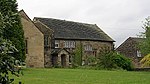 More images |
| Church of St John the Evangelist | Leeds city centre | Church | 1632-1634 | 26 September 1963 | SE3024333855 53°48′00″N 1°32′32″W / 53.800124°N 1.542314°W / 53.800124; -1.542314 (Church of St John the Evangelist) | 1375157 |  More images |
| Church of St John the Baptist | Adel, Leeds | Anglican Church | 1150-1170 | 26 September 1963 | SE2746240235 53°51′27″N 1°35′02″W / 53.857619°N 1.583968°W / 53.857619; -1.583968 (Church of St John the Baptist) | 1255610 | 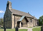 More images |
| Church of St Mary | Whitkirk | Anglican Church | 15th century | 26 September 1963 | SE3635033582 53°47′50″N 1°26′59″W / 53.797281°N 1.44963°W / 53.797281; -1.44963 (Church of St Mary) | 1375130 |  More images |
| Church of St Oswald | Guiseley | Church | 11th century | 19 October 1962 | SE1941542145 53°52′31″N 1°42′22″W / 53.875147°N 1.706188°W / 53.875147; -1.706188 (Church of St Oswald) | 1135598 | 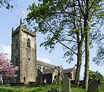 More images |
| Church of St Oswald | Methley | Parish Church | 14th century | 5 June 1964 | SE3910826620 53°44′04″N 1°24′31″W / 53.734511°N 1.408641°W / 53.734511; -1.408641 (Church of St Oswald) | 1135664 |  More images |
| Church of St Saviour | Richmond Hill, Leeds | Anglican Church | 1842-1845 | 26 September 1963 | SE3129032944 53°47′31″N 1°31′35″W / 53.791875°N 1.526511°W / 53.791875; -1.526511 (Church of St Saviour) | 1375400 | 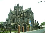 More images |
| Church of the Epiphany | Gipton, Leeds | Anglican Church | 1936-1938 | 25 June 1993 | SE3356435305 53°48′47″N 1°29′30″W / 53.812953°N 1.491737°W / 53.812953; -1.491737 (Church of the Epiphany) | 1255904 |  More images |
| Leeds City Markets | Leeds city centre | Market Hall | c. 1875 | 8 May 1973 | SE3045033526 53°47′50″N 1°32′21″W / 53.797155°N 1.539204°W / 53.797155; -1.539204 (Leeds City Markets) | 1255765 |  More images |
| Leeds Corn Exchange | Leeds city centre | Corn exchange | 1863 | 19 October 1951 | SE3039333387 53°47′45″N 1°32′24″W / 53.795909°N 1.540083°W / 53.795909; -1.540083 (Leeds Corn Exchange) | 1255771 |  More images |
| Fulneck Moravian Church and Attached Ranges to Either Side including the Boys' School and Girls' School | Fulneck Moravian Settlement, Pudsey | Moravian Settlement | 1746-48 | 17 May 1972 | SE2221031999 53°47′02″N 1°39′52″W / 53.783846°N 1.664406°W / 53.783846; -1.664406 (Fulneck Moravian Church and Attached Ranges to Either Side including the Boys' School and Girls' School) | 1135096 |  More images |
| Holy Trinity Church | Leeds city centre | Anglican Church | 1721-1727 | 26 September 1963 | SE3016433415 53°47′46″N 1°32′37″W / 53.796174°N 1.543556°W / 53.796174; -1.543556 (Holy Trinity Church) | 1255870 | 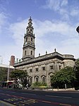 More images |
| Kirkstall Abbey | Kirkstall, Leeds | Abbey | 1152-1182 | 26 September 1963 | SE2597736085 53°49′13″N 1°36′25″W / 53.820396°N 1.606894°W / 53.820396; -1.606894 (Kirkstall Abbey) | 1256668 |  More images |
| Leeds General Infirmary | Leeds city centre | Hospital | 1863-68 | 8 October 1970 | SE2967233991 53°48′05″N 1°33′03″W / 53.801379°N 1.55097°W / 53.801379; -1.55097 (Leeds General Infirmary) | 1256242 |  More images |
| Leeds Minster | Leeds city centre | Church | 1839-1841 | 26 September 1963 | SE3065833301 53°47′42″N 1°32′10″W / 53.795121°N 1.536068°W / 53.795121; -1.536068 (Leeds Minster) | 1375046 |  More images |
| Temple Mill | Holbeck, Leeds | Fireproof Factory | 1838-1840 | 19 October 1951 | SE2952532691 53°47′23″N 1°33′12″W / 53.789704°N 1.553326°W / 53.789704; -1.553326 (Temple Mill) | 1375162 |  More images |
| Temple Newsam House | Temple Newsam, Leeds | Country House | Early 16th century | 19 October 1951 | SE3571232108 53°47′03″N 1°27′34″W / 53.784078°N 1.459486°W / 53.784078; -1.459486 (Temple Newsam House) | 1255943 | 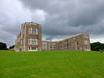 More images |
| Leeds Town Hall | Leeds city centre | Town Hall | 1853-1858 | 19 October 1951 | SE2975233866 53°48′01″N 1°32′59″W / 53.800251°N 1.549767°W / 53.800251; -1.549767 (Leeds Town Hall) | 1255772 | 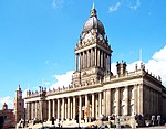 More images |
Wakefield
| Name | Location | Type | Completed [note 1] | Date designated | Grid ref.[note 2] Geo-coordinates | Entry number [note 3] | Image |
|---|---|---|---|---|---|---|---|
| Ackworth School (that Part Comprising Centre Block & East and West Wings, Shed Court, Main Entrance) | Low Ackworth, Ackworth | Courtyard | 1786 | 6 June 1952 | SE4409117122 53°38′56″N 1°20′04″W / 53.648751°N 1.334457°W / 53.648751; -1.334457 (Ackworth School (that Part Comprising Centre Block & East and West Wings, Shed Court, Main Entrance)) | 1025067 |  More images |
| Church of St Mary | Badsworth | Parish Church | 15th century | 25 March 1968 | SE4633214972 53°37′45″N 1°18′03″W / 53.629235°N 1.300876°W / 53.629235; -1.300876 (Church of St Mary) | 1052219 | 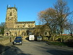 More images |
| Church of St Luke and All Saints | Darrington | Church | Norman | 11 December 1967 | SE4850820179 53°40′33″N 1°16′02″W / 53.675836°N 1.267165°W / 53.675836; -1.267165 (Church of St Luke and All Saints) | 1313210 |  More images |
| Church of St Peter and St Leonard | Horbury | Church | Saxon | 15 February 1966 | SE2951518368 53°39′39″N 1°33′17″W / 53.660972°N 1.554839°W / 53.660972; -1.554839 (Church of St Peter and St Leonard) | 1135508 | 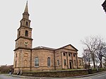 More images |
| Horbury Hall | Horbury | Hall House | 1478-92 | 15 February 1966 | SE2954218336 53°39′38″N 1°33′16″W / 53.660683°N 1.554433°W / 53.660683; -1.554433 (Horbury Hall) | 1135510 | 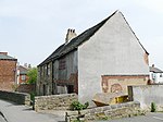 More images |
| Kettlethorpe Hall | Kettlethorpe | House | 1727 | 14 July 1953 | SE3330016698 53°38′45″N 1°29′52″W / 53.645736°N 1.497743°W / 53.645736; -1.497743 (Kettlethorpe Hall) | 1259736 |  More images |
| Church of St Michael and Our Lady (Wragby Parish Church) | Nostell Park, Nostell | Church | Dated 1533 | 25 March 1968 | SE4077617299 53°39′02″N 1°23′04″W / 53.65061°N 1.38458°W / 53.65061; -1.38458 (Church of St Michael and Our Lady (Wragby Parish Church)) | 1253565 |  More images |
| Nostell Priory | Nostell Park, Nostell | Country House | 1736-50 | 6 June 1952 | SE4040917526 53°39′10″N 1°23′24″W / 53.652679°N 1.390103°W / 53.652679; -1.390103 (Nostell Priory) | 1262071 |  More images |
| Stables at Nostell Priory | Nostell Park, Nostell | Garage | 1952 | 6 June 1952 | SE4047817405 53°39′06″N 1°23′21″W / 53.651586°N 1.389075°W / 53.651586; -1.389075 (Stables at Nostell Priory) | 1253558 |  More images |
| Stanley Ferry Aqueduct | Normanton | Aqueduct | 1837-39 | 9 October 1987 | SE3558023028 53°42′09″N 1°27′45″W / 53.702479°N 1.462531°W / 53.702479; -1.462531 (Stanley Ferry Aqueduct) | 1261690 |  More images |
| The Hermitage, under the Infirmary. | Pontefract | Hermitage | Medieval | 15 November 1988 | SE4566721793 53°41′26″N 1°18′36″W / 53.690597°N 1.309931°W / 53.690597; -1.309931 (The Hermitage, under the Infirmary.) | 1135427 | Upload Photo |
| Church of St Peter | Felkirk, South Hiendley | Parish Church | Norman | 25 March 1968 | SE3868912603 53°36′31″N 1°25′00″W / 53.608562°N 1.416734°W / 53.608562; -1.416734 (Church of St Peter) | 1265442 | 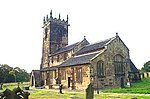 More images |
| Church of All Saints | South Kirkby | Parish Church | 13th century | 25 March 1968 | SE4529711071 53°35′39″N 1°19′02″W / 53.594264°N 1.317092°W / 53.594264; -1.317092 (Church of All Saints) | 1227519 |  More images |
| Frieston's Hospital | Heath Common, Wakefield | Almshouse | c. 1595 | 14 February 1952 | SE3607220896 53°41′00″N 1°27′19″W / 53.683283°N 1.455326°W / 53.683283; -1.455326 (Frieston's Hospital) | 1313217 |  More images |
| Heath Hall | Heath Common, Wakefield | Country House | c. 1709 | 14 February 1952 | SE3555820186 53°40′37″N 1°27′47″W / 53.676937°N 1.463189°W / 53.676937; -1.463189 (Heath Hall) | 1200238 |  More images |
| Flanking Screen Walls and Gate Piers Attached to West Front of Heath Hall Linking East and West Pavilions | Heath Common, Wakefield | Gate Pier | c. 1767 | 14 February 1952 | SE3557720156 53°40′36″N 1°27′46″W / 53.676666°N 1.462905°W / 53.676666; -1.462905 (Flanking Screen Walls and Gate Piers Attached to West Front of Heath Hall Linking East and West Pavilions) | 1200345 | Upload Photo |
| The Brewhouse and East Pavilion at Heath Hall | Heath Common, Wakefield | Apartment | 1982-84 | 14 February 1952 | SE3559320155 53°40′36″N 1°27′46″W / 53.676656°N 1.462663°W / 53.676656; -1.462663 (The Brewhouse and East Pavilion at Heath Hall) | 1313191 |  |
| The Stable House, Heath Hall | Heath Common, Wakefield | Bothy | c. 1754 | 14 February 1952 | SE3554720243 53°40′39″N 1°27′48″W / 53.67745°N 1.463349°W / 53.67745; -1.463349 (The Stable House, Heath Hall) | 1135583 |  |
| The West Pavilion, Heath Hall | Heath Common, Wakefield | Flats | 1986 | 14 February 1952 | SE3554820210 53°40′38″N 1°27′48″W / 53.677154°N 1.463338°W / 53.677154; -1.463338 (The West Pavilion, Heath Hall) | 1200273 |  |
| Church of St Peter | Woolley | Church | 15th century | 22 November 1966 | SE3193613016 53°36′46″N 1°31′08″W / 53.612727°N 1.518752°W / 53.612727; -1.518752 (Church of St Peter) | 1200723 | 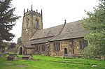 More images |
| Cathedral Church of All Saints | Wakefield city centre | Cathedral | Early 15th century | 14 July 1953 | SE3333220841 53°40′59″N 1°29′49″W / 53.68297°N 1.496815°W / 53.68297; -1.496815 (Cathedral Church of All Saints) | 1258237 |  More images |
| Chapel of St Mary on East Side of Wakefield Bridge | Wakefield city centre | Bridge Chapel | c. 1350 | 14 July 1953 | SE3382320140 53°40′36″N 1°29′22″W / 53.676639°N 1.489458°W / 53.676639; -1.489458 (Chapel of St Mary on East Side of Wakefield Bridge) | 1258242 |  More images |
| County Hall (offices of West Yorkshire County Council) | Wakefield city centre | County Hall | 1894-98 | 30 March 1971 | SE3295521008 53°41′04″N 1°30′09″W / 53.684495°N 1.502505°W / 53.684495; -1.502505 (County Hall (offices of West Yorkshire County Council)) | 1242349 |  More images |
| Town Hall | Wakefield city centre | Local Government Office | 1971 | 30 March 1971 | SE3302720927 53°41′02″N 1°30′05″W / 53.683763°N 1.501424°W / 53.683763; -1.501424 (Town Hall) | 1258995 |  More images |
| Wakefield Bridge | Wakefield city centre | Bridge | Early-Mid 14th century | 14 July 1953 | SE3381020135 53°40′36″N 1°29′23″W / 53.676594°N 1.489655°W / 53.676594; -1.489655 (Wakefield Bridge) | 1273508 |  More images |
See also
- Category:Grade I listed buildings in West Yorkshire
- Grade II* listed buildings in West Yorkshire
Notes
- ^ a b c d e The date given is the date used by Historic England as significant for the initial building or that of an important part in the structure's description.
- ^ a b c d e Sometimes known as OSGB36, the grid reference is based on the British national grid reference system used by the Ordnance Survey.
- ^ a b c d e The "List Entry Number" is a unique number assigned to each listed building and scheduled monument by Historic England.
Sources
- National Heritage List for England
References
- ^ Woodsome Hall website - Contacts
External links
![]() Media related to Grade I listed buildings in West Yorkshire at Wikimedia Commons
Media related to Grade I listed buildings in West Yorkshire at Wikimedia Commons
- v
- t
- e
- Bedfordshire
- Berkshire
- Bristol
- Buckinghamshire
- Cambridgeshire
- Cheshire
- Cornwall
- Cumbria
- Derbyshire
- Devon
- Dorset
- Durham
- East Sussex
- East Riding of Yorkshire
- Essex
- Gloucestershire
- Greater London
- Greater Manchester
- Hampshire
- Herefordshire
- Hertfordshire
- Isle of Wight
- Kent
- Lancashire
- Leicestershire
- Lincolnshire
- Merseyside
- Norfolk
- North Yorkshire
- Northamptonshire
- Northumberland
- Nottinghamshire
- Oxfordshire
- Rutland
- Shropshire
- Somerset
- South Yorkshire
- Staffordshire
- Suffolk
- Surrey
- Tyne and Wear
- Warwickshire
- West Midlands
- West Sussex
- West Yorkshire
- Wiltshire
- Worcestershire
- Babergh
- Bath and North East Somerset
- Bradford
- Brighton and Hove
- Broadland
- Cheltenham
- Cheshire East
- Cheshire West and Chester
- Cotswold
- Craven
- Dartford
- Dover
- Forest Heath
- Forest of Dean
- Ipswich
- Maidstone
- Mendip
- Mid Suffolk
- North Somerset
- Sedgemoor
- South Gloucestershire
- South Somerset
- St Edmundsbury
- Stroud
- Suffolk Coastal
- Taunton Deane
- Tewkesbury
- Waveney
- West Somerset
- Churches
- War memorials
- 20th century


