Grade I listed buildings in the City of York
Map all coordinates using OpenStreetMap
Download coordinates as:
- KML
- GPX (all coordinates)
- GPX (primary coordinates)
- GPX (secondary coordinates)
There are over 9,000 Grade I listed buildings in England. This page is a list of these buildings in the City of York in North Yorkshire.
List of buildings
| Name | Location | Type | Completed [note 1] | Date designated | Grid ref.[note 2] Geo-coordinates | Entry number [note 3] | Image |
|---|---|---|---|---|---|---|---|
| Church of the Holy Trinity | Acaster Malbis | Church | Early 14th century | 3 February 1967 | SE5937445835 53°54′19″N 1°05′52″W / 53.905284°N 1.097763°W / 53.905284; -1.097763 (Church of the Holy Trinity) | 1148450 |  More images |
| Church of St Nicholas | Askham Bryan | Church | 12th century | 12 July 1985 | SE5538048472 53°55′46″N 1°09′29″W / 53.929423°N 1.158071°W / 53.929423; -1.158071 (Church of St Nicholas) | 1132520 |  More images |
| Bishopthorpe Palace and Chapel | Bishopthorpe | Archbishop's palace | 13th century | 4 July 1952 | SE5972047824 53°55′23″N 1°05′32″W / 53.923118°N 1.09211°W / 53.923118; -1.09211 (Bishopthorpe Palace and Chapel) | 1132487 |  More images |
| Bell Hall | Naburn | House | 1680 | 25 October 1951 | SE5996643747 53°53′11″N 1°05′21″W / 53.886451°N 1.089162°W / 53.886451; -1.089162 (Bell Hall) | 1296999 |  More images |
| Church of St Giles | Skelton | Church | c.1240 | 12 December 1986 | SE5684956557 54°00′07″N 1°08′03″W / 54.001921°N 1.134198°W / 54.001921; -1.134198 (Church of St Giles) | 1315980 |  More images |
| Church of Saint Helen | Wheldrake | Church | 14th century | 7 November 1966 | SE6827844985 53°53′48″N 0°57′45″W / 53.896551°N 0.962449°W / 53.896551; -0.962449 (Church of Saint Helen) | 1148480 |  More images |
| Anglian Tower | York | Tower | Probably 7th-century on Roman footings | 14 June 1954 | SE6004552135 53°57′43″N 1°05′11″W / 53.961822°N 1.086316°W / 53.961822; -1.086316 (Anglian Tower) | 1257157 |  More images |
| Arcade of former Archbishop's Palace and attached railings and gates | York | Archbishop's palace | Late 12th century | 14 June 1954 | SE6026052289 53°57′47″N 1°04′59″W / 53.963181°N 1.083009°W / 53.963181; -1.083009 (Arcade of former Archbishop's Palace and attached railings and gates) | 1257919 |  More images |
| City Wall from Baile Hill to Barker Tower | York | Tower | Early 14th century | 14 June 1954 | SE5968351630 53°57′26″N 1°05′31″W / 53.957326°N 1.091931°W / 53.957326; -1.091931 (City Wall from Baile Hill to Barker Tower) | 1259262 |  More images |
| City Wall from Bootham Bar to Layerthorpe | York | Tower | 1250–70 | 14 June 1954 | SE6028452411 53°57′51″N 1°04′57″W / 53.964275°N 1.082619°W / 53.964275; -1.082619 (City Wall from Bootham Bar to Layerthorpe) | 1259293 |  More images |
| Bootham Park Hospital | York | Psychiatric hospital | c.1790 | 24 June 1983 | SE6010652772 53°58′03″N 1°05′07″W / 53.967539°N 1.085261°W / 53.967539; -1.085261 (Bootham Park Hospital) | 1259396 |  More images |
| York Castle Museum, the Debtors Prison, Castle Precinct | York | Prison | 1701–05 | 14 June 1954 | SE6053651369 53°57′18″N 1°04′44″W / 53.954881°N 1.078985°W / 53.954881; -1.078985 (York Castle Museum, the Debtors Prison, Castle Precinct) | 1259360 |  More images |
| York Castle Museum, the Female Prison, Castle Precinct | York | Prison | 1820–50 | 14 June 1954 | SE6058451438 53°57′20″N 1°04′42″W / 53.955496°N 1.07824°W / 53.955496; -1.07824 (York Castle Museum, the Female Prison, Castle Precinct) | 1259324 |  More images |
| Castlegate House and attached railings | York | Town house | 1762–63 | 14 June 1954 | SE6042651573 53°57′24″N 1°04′50″W / 53.956727°N 1.080621°W / 53.956727; -1.080621 (Castlegate House and attached railings) | 1259338 |  More images |
| Cathedral Church of St Peter, York Minster | York | Cathedral | 1410–70 | 14 June 1954 | SE6032352180 53°57′44″N 1°04′55″W / 53.962194°N 1.08207°W / 53.962194; -1.08207 (Cathedral Church of St Peter, York Minster) | 1257222 |  More images |
| Church of All Saints, Pavement | York | Parish church | 14th century | 14 June 1954 | SE6041951721 53°57′29″N 1°04′51″W / 53.958058°N 1.080698°W / 53.958058; -1.080698 (Church of All Saints, Pavement) | 1256921 | 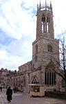 More images |
| Church of All Saints North Street with Anchorage Attached | York | Anchorite cell | 15th century | 14 June 1954 | SE6005351758 53°57′30″N 1°05′11″W / 53.958433°N 1.086268°W / 53.958433; -1.086268 (Church of All Saints North Street with Anchorage Attached) | 1257067 |  More images |
| Holy Trinity Goodramgate | York | Parish church | Early 12th century | 14 June 1954 | SE6043552052 53°57′40″N 1°04′49″W / 53.961031°N 1.080389°W / 53.961031; -1.080389 (Holy Trinity Goodramgate) | 1257686 |  More images |
| Church of Holy Trinity, Micklegate and wall attached to south east | York | Church | Early 12th century | 14 June 1954 | SE5988951547 53°57′24″N 1°05′20″W / 53.956556°N 1.088808°W / 53.956556; -1.088808 (Church of Holy Trinity, Micklegate and wall attached to south east) | 1257274 |  More images |
| Church of St Cuthbert | York | Parish church | Late 11th century | 14 June 1954 | SE6077052033 53°57′39″N 1°04′31″W / 53.960821°N 1.075288°W / 53.960821; -1.075288 (Church of St Cuthbert) | 1256888 |  More images |
| Church of St Denys | York | Parish church | 14th century | 14 June 1954 | SE6071351574 53°57′24″N 1°04′34″W / 53.956703°N 1.076247°W / 53.956703; -1.076247 (Church of St Denys) | 1256313 |  More images |
| Church of St Margaret Walmgate | York | Church | Late 12th century and later | 14 June 1954 | SE6095251566 53°57′24″N 1°04′21″W / 53.956603°N 1.072607°W / 53.956603; -1.072607 (Church of St Margaret Walmgate) | 1256319 |  More images |
| Church of St Martin Cum Gregory | York | Church | 11th-century nave | 14 June 1954 | SE6000551609 53°57′26″N 1°05′13″W / 53.9571°N 1.087029°W / 53.9571; -1.087029 (Church of St Martin Cum Gregory) | 1257277 |  More images |
| Church of St Mary Bishophill Junior | York | Parish church | 10th century | 14 June 1954 | SE5999651474 53°57′21″N 1°05′14″W / 53.955888°N 1.087192°W / 53.955888; -1.087192 (Church of St Mary Bishophill Junior) | 1259548 |  More images |
| Church of St Michael Spurriergate | York | Church hall | Late 12th-century arcades | 14 June 1954 | SE6029451694 53°57′28″N 1°04′57″W / 53.95783°N 1.082608°W / 53.95783; -1.082608 (Church of St Michael Spurriergate) | 1256593 |  More images |
| Church of St Michael Le Belfrey | York | Parish church | 1525–37 | 14 June 1954 | SE6027952128 53°57′42″N 1°04′58″W / 53.961732°N 1.082751°W / 53.961732; -1.082751 (Church of St Michael Le Belfrey) | 1257228 |  More images |
| Church of St Olave | York | Parish church | 13th century | 14 June 1954 | SE5986452186 53°57′44″N 1°05′21″W / 53.962301°N 1.089064°W / 53.962301; -1.089064 (Church of St Olave) | 1257387 |  More images |
| City Wall from Lendall Hill House to the Lodge, Museum Gardens | York | Town wall | 1250–70 | 14 June 1954 | SE6001452008 53°57′38″N 1°05′13″W / 53.960684°N 1.086813°W / 53.960684; -1.086813 (City Wall from Lendall Hill House to the Lodge, Museum Gardens) | 1259290 |  More images |
| City Wall from Multangular Tower to rear of Number 8 St Leonards Place | York | Town wall | 1250–70 | 14 June 1954 | SE6002952117 53°57′42″N 1°05′12″W / 53.961662°N 1.086563°W / 53.961662; -1.086563 (City Wall from Multangular Tower to rear of Number 8 St Leonards Place) | 1259292 | 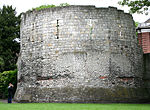 More images |
| City Wall from the Red Tower to Fishergate (Postern Tower, Fishergate Bar, Fishergate Postern Tower, the Red Tower, Walmgate Bar) | York | Town wall | Mid-14th century and later | 14 June 1954 | SE6069451256 53°57′14″N 1°04′36″W / 53.953847°N 1.0766°W / 53.953847; -1.0766 (City Wall from the Red Tower to Fishergate (Postern Tower, Fishergate Bar, Fishergate Postern Tower, the Red Tower, Walmgate Bar)) | 1259296 |  More images |
| City Walls attached to Tower Place | York | Town wall | Late 13th century | 24 June 1983 | SE6040351412 53°57′19″N 1°04′52″W / 53.955283°N 1.081003°W / 53.955283; -1.081003 (City Walls attached to Tower Place) | 1259260 |  More images |
| Cliffords Tower, Castle Precinct | York | Keep | 1245–72 | 14 June 1954 | SE6046351467 53°57′21″N 1°04′48″W / 53.95577°N 1.080078°W / 53.95577; -1.080078 (Cliffords Tower, Castle Precinct) | 1259325 |  More images |
| Crown Court and railings attached to front, Castle Precinct | York | Court house | 1773–77 | 14 June 1954 | SE6051751399 53°57′19″N 1°04′45″W / 53.955153°N 1.079269°W / 53.955153; -1.079269 (Crown Court and railings attached to front, Castle Precinct) | 1259328 |  More images |
| Cumberland House | York | Town house | c.1710 | 14 June 1954 | SE6028551584 53°57′25″N 1°04′58″W / 53.956843°N 1.082767°W / 53.956843; -1.082767 (Cumberland House) | 1257526 |  More images |
| Curtain Wall, Castle Precinct | York | Tower | c.1250 | 14 June 1954 | SE6057751374 53°57′18″N 1°04′42″W / 53.954921°N 1.078359°W / 53.954921; -1.078359 (Curtain Wall, Castle Precinct) | 1259329 |  More images |
| Fairfax House | York | House | c.1744 | 14 June 1954 | SE6046351578 53°57′24″N 1°04′48″W / 53.956768°N 1.080056°W / 53.956768; -1.080056 (Fairfax House) | 1259337 |  More images |
| Garforth House and railings attached at front, garden wall attached at rear | York | Town house | 1757 | 14 June 1954 | SE5995251651 53°57′27″N 1°05′16″W / 53.957483°N 1.087828°W / 53.957483; -1.087828 (Garforth House and railings attached at front, garden wall attached at rear) | 1257335 |  More images |
| Goddards and attached gateway, terrace and loggia to side and rear | Dringhouses, York | House | 1926–27 | 24 June 1983 | SE5891249721 53°56′25″N 1°06′15″W / 53.940258°N 1.104047°W / 53.940258; -1.104047 (Goddards and attached gateway, terrace and loggia to side and rear) | 1256461 |  More images |
| Grays Court and garden gates and piers attached to south-east corner | York | House | 12th century | 14 June 1954 | SE6041052301 53°57′48″N 1°04′51″W / 53.963271°N 1.080721°W / 53.963271; -1.080721 (Grays Court and garden gates and piers attached to south-east corner) | 1257248 |  More images |
| York Guildhall | York | Guidhall | 1449–59 | 14 June 1954 | SE6009251894 53°57′35″N 1°05′08″W / 53.959651°N 1.085647°W / 53.959651; -1.085647 (York Guildhall) | 1257929 |  More images |
| Jacobs Well | York | House | Early 16th century | 14 June 1954 | SE5990851574 53°57′24″N 1°05′19″W / 53.956796°N 1.088514°W / 53.956796; -1.088514 (Jacobs Well) | 1256384 |  More images |
| Judges Lodging | York | Town house | c.1715 | 14 June 1954 | SE6011552002 53°57′38″N 1°05′07″W / 53.960619°N 1.085275°W / 53.960619; -1.085275 (Judges Lodging) | 1257487 |  More images |
| Lady Row | York | Jettied house | 1317 | 14 June 1954 | SE6045752039 53°57′39″N 1°04′48″W / 53.960911°N 1.080056°W / 53.960911; -1.080056 (Lady Row) | 1257710 | 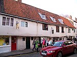 More images |
| Lendal Tower | York | Tower | c.1300 | 14 June 1954 | SE5999151959 53°57′37″N 1°05′14″W / 53.960247°N 1.087173°W / 53.960247; -1.087173 (Lendal Tower) | 1257086 |  More images |
| Mansion House, railings and gas lamps attached to front | York | House | 1725–33 | 14 June 1954 | SE6014551921 53°57′36″N 1°05′05″W / 53.959887°N 1.084834°W / 53.959887; -1.084834 (Mansion House, railings and gas lamps attached to front) | 1257969 |  More images |
| Merchant Adventurers' Hall | York | Exchange | 1357–61 | 14 June 1954 | SE6054751705 53°57′28″N 1°04′44″W / 53.957899°N 1.078751°W / 53.957899; -1.078751 (Merchant Adventurers' Hall) | 1257828 |  More images |
| Merchant Taylors Hall | York | Guildhall | c.1400 | 14 June 1954 | SE6064452153 53°57′43″N 1°04′38″W / 53.961914°N 1.077184°W / 53.961914; -1.077184 (Merchant Taylors Hall) | 1259571 |  More images |
| Micklegate House and attached railings and lamp brackets | York | House | 1752 | 14 June 1954 | SE5985451600 53°57′25″N 1°05′22″W / 53.957036°N 1.089331°W / 53.957036; -1.089331 (Micklegate House and attached railings and lamp brackets) | 1257285 |  More images |
| Minster Library | York | Archbishop's palace | c.1230 | 14 June 1954 | SE6029952309 53°57′48″N 1°04′57″W / 53.963356°N 1.082411°W / 53.963356; -1.082411 (Minster Library) | 1257880 |  More images |
| Multangular Tower, and wall attached to south-east, Museum Gardens | York | Tower | Late 13th century | 14 June 1954 | SE6001252072 53°57′41″N 1°05′13″W / 53.96126°N 1.086831°W / 53.96126; -1.086831 (Multangular Tower, and wall attached to south-east, Museum Gardens) | 1257120 |  More images |
| Number 23, High Petergate and attached garden wall and outbuilding | York | House | c.1779 | 14 June 1954 | SE6024552121 53°57′42″N 1°05′00″W / 53.961673°N 1.083271°W / 53.961673; -1.083271 (Number 23, High Petergate and attached garden wall and outbuilding) | 1257607 |  More images |
| Roman Wall approximately 20 metres south-east of Monk Bar | York | Roman wall | c.200 | 14 June 1954 | SE6062252178 53°57′44″N 1°04′39″W / 53.962141°N 1.077514°W / 53.962141; -1.077514 (Roman Wall approximately 20 metres south-east of Monk Bar) | 1259572 |  More images |
| St Anthony's Hall | York | Prison | 1655 | 14 June 1954 | SE6073151989 53°57′38″N 1°04′33″W / 53.96043°N 1.075891°W / 53.96043; -1.075891 (St Anthony's Hall) | 1256892 |  More images |
| St Leonard's Hospital remains | York | Chapel | c.1240 | 14 June 1954 | SE6005252049 53°57′40″N 1°05′10″W / 53.961048°N 1.086226°W / 53.961048; -1.086226 (St Leonard's Hospital remains) | 1257087 |  More images |
| St Mary's Abbey remains: Church | York | Abbey | 1089 | 14 June 1954 | SE5993652174 53°57′44″N 1°05′17″W / 53.962185°N 1.087969°W / 53.962185; -1.087969 (St Mary's Abbey remains: Church) | 1257128 |  More images |
| St Mary's Abbey remains: Precinct Walls, St Mary's Tower | York | Tower | 1324 | 14 June 1954 | SE5979952130 53°57′43″N 1°05′24″W / 53.961806°N 1.090066°W / 53.961806; -1.090066 (St Mary's Abbey remains: Precinct Walls, St Mary's Tower) | 1257131 |  More images |
| St Mary's Lodge and attached railings, gates and gate piers, at St Mary's Abbey | York | Abbey | Late 12th century | 14 June 1954 | SE5983752159 53°57′43″N 1°05′22″W / 53.962062°N 1.089481°W / 53.962062; -1.089481 (St Mary's Lodge and attached railings, gates and gate piers, at St Mary's Abbey) | 1257136 |  More images |
| St William's College | York | Chantry college | c.1465 and later | 14 June 1954 | SE6044752195 53°57′44″N 1°04′49″W / 53.962315°N 1.080178°W / 53.962315; -1.080178 (St William's College) | 1258028 |  More images |
| The Assembly Rooms | York | Assembly rooms | 1730 | 14 June 1954 | SE6012352039 53°57′39″N 1°05′07″W / 53.96095°N 1.085146°W / 53.96095; -1.085146 (The Assembly Rooms) | 1259521 |  More images |
| The Bar Convent and railings attached to front | York | Courtyard | c.1865 | 14 June 1954 | SE5975151353 53°57′17″N 1°05′27″W / 53.954829°N 1.090949°W / 53.954829; -1.090949 (The Bar Convent and railings attached to front) | 1259503 |  More images |
| Nos. 12 and 14, The Herbert House | York | House | Mid-17th century | 14 June 1954 | SE6048651782 53°57′31″N 1°04′47″W / 53.958599°N 1.079665°W / 53.958599; -1.079665 (Nos. 12 and 14, The Herbert House) | 1256914 |  More images |
| King's Manor | York | Apartment | 1483–1502 | 14 June 1954 | SE6000452127 53°57′42″N 1°05′13″W / 53.961755°N 1.086942°W / 53.961755; -1.086942 (King's Manor) | 1257855 |  More images |
| The Norman House | Stonegate, York | Hall house | Late 12th century | 14 June 1954 | SE6025452078 53°57′41″N 1°04′59″W / 53.961286°N 1.083142°W / 53.961286; -1.083142 (The Norman House) | 1256494 |  More images |
| The Wealden Hall | Goodramgate, York | Wealden house | c.1500 | 14 June 1954 | SE6047952092 53°57′41″N 1°04′47″W / 53.961385°N 1.07971°W / 53.961385; -1.07971 (The Wealden Hall) | 1257745 |  More images |
| St Mary's church, Castlegate (The York Story) | York | Exhibition hall | 15th century | 14 June 1954 | SE6044051624 53°57′26″N 1°04′49″W / 53.957184°N 1.080397°W / 53.957184; -1.080397 (St Mary's church, Castlegate (The York Story)) | 1259342 |  More images |
| Treasurer's House and attached garden walls, gate and gate piers | York | House | 16th century | 14 June 1954 | SE6040752268 53°57′47″N 1°04′51″W / 53.962975°N 1.080773°W / 53.962975; -1.080773 (Treasurer's House and attached garden walls, gate and gate piers) | 1257251 |  More images |
| Wall approx. 5 metres north-east of the Kings Manor | York | Wall | c.1266 | 24 June 1983 | SE6006452195 53°57′44″N 1°05′10″W / 53.962359°N 1.086014°W / 53.962359; -1.086014 (Wall approx. 5 metres north-east of the Kings Manor) | 1257859 |  More images |
| Wall approx. 2 metres north of Number 9, St Leonard's Place | York | Roman wall | c.300 Roman | 24 June 1983 | SE6007952174 53°57′44″N 1°05′09″W / 53.962169°N 1.08579°W / 53.962169; -1.08579 (Wall approx. 2 metres north of Number 9, St Leonard's Place) | 1256762 |  More images |
| West tower of the Old Church of St Lawrence | York | Tower | Late 12th century | 14 June 1954 | SE6122551303 53°57′15″N 1°04′07″W / 53.954207°N 1.0685°W / 53.954207; -1.0685 (West tower of the Old Church of St Lawrence) | 1257511 |  More images |
| Yorkshire Museum, Tempest Anderson Hall and St Marys Abbey Remains | York | Museum | Late 12th century | 14 June 1954 | SE5996552135 53°57′43″N 1°05′15″W / 53.961831°N 1.087535°W / 53.961831; -1.087535 (Yorkshire Museum, Tempest Anderson Hall and St Marys Abbey Remains) | 1257100 |  More images |
| No. 41, 43 and 45 Goodramgate | York | Italian restaurant | c.1500 | 14 June 1954 | SE6048252117 53°57′42″N 1°04′47″W / 53.961609°N 1.07966°W / 53.961609; -1.07966 (No. 41, 43 and 45 Goodramgate) | 1257738 |  More images |
See also
- Grade II* listed buildings in the City of York
- Grade I listed buildings in North Yorkshire
- Grade I listed buildings in Selby (district)
- Grade I listed buildings in Harrogate (borough)
- Grade I listed buildings in Craven
- Grade I listed buildings in Richmondshire
- Grade I listed buildings in Hambleton
- Grade I listed buildings in Ryedale
- Grade I listed buildings in Scarborough (borough)
- Grade I listed buildings in Redcar and Cleveland
- Grade I listed buildings in Middlesbrough (borough)
- Grade I listed buildings in Stockton-on-Tees
Notes
- ^ The date given is the date used by Historic England as significant for the initial building or that of an important part in the structure's description.
- ^ Sometimes known as OSGB36, the grid reference is based on the British national grid reference system used by the Ordnance Survey.
- ^ The "List Entry Number" is a unique number assigned to each listed building and scheduled monument by Historic England.
External links
![]() Media related to Grade I listed buildings in York at Wikimedia Commons
Media related to Grade I listed buildings in York at Wikimedia Commons
- v
- t
- e
- Bedfordshire
- Berkshire
- Bristol
- Buckinghamshire
- Cambridgeshire
- Cheshire
- Cornwall
- Cumbria
- Derbyshire
- Devon
- Dorset
- Durham
- East Sussex
- East Riding of Yorkshire
- Essex
- Gloucestershire
- Greater London
- Greater Manchester
- Hampshire
- Herefordshire
- Hertfordshire
- Isle of Wight
- Kent
- Lancashire
- Leicestershire
- Lincolnshire
- Merseyside
- Norfolk
- North Yorkshire
- Northamptonshire
- Northumberland
- Nottinghamshire
- Oxfordshire
- Rutland
- Shropshire
- Somerset
- South Yorkshire
- Staffordshire
- Suffolk
- Surrey
- Tyne and Wear
- Warwickshire
- West Midlands
- West Sussex
- West Yorkshire
- Wiltshire
- Worcestershire
- Babergh
- Bath and North East Somerset
- Bradford
- Brighton and Hove
- Broadland
- Cheltenham
- Cheshire East
- Cheshire West and Chester
- Cotswold
- Craven
- Dartford
- Dover
- Forest Heath
- Forest of Dean
- Ipswich
- Maidstone
- Mendip
- Mid Suffolk
- North Somerset
- Sedgemoor
- South Gloucestershire
- South Somerset
- St Edmundsbury
- Stroud
- Suffolk Coastal
- Taunton Deane
- Tewkesbury
- Waveney
- West Somerset
- Churches
- War memorials
- 20th century


