National Register of Historic Places listings in Escambia County, Florida

This is a list of the National Register of Historic Places listings in Escambia County, Florida.
This is intended to be a complete list of the properties and districts on the National Register of Historic Places in Escambia County, Florida, United States. The locations of National Register properties and districts for which the latitude and longitude coordinates are included below, may be seen in a map.[1]
There are 42 properties and districts listed on the National Register in the county, including 3 National Historic Landmarks. Another 3 properties were once listed but have been removed.
This National Park Service list is complete through NPS recent listings posted April 26, 2024.[2]
Map all coordinates using OpenStreetMap
Download coordinates as:
- KML
- GPX (all coordinates)
- GPX (primary coordinates)
- GPX (secondary coordinates)
| Alachua - Baker - Bay - Bradford - Brevard - Broward - Calhoun - Charlotte - Citrus - Clay - Collier - Columbia - DeSoto - Dixie - Duval - Escambia - Flagler - Franklin - Gadsden - Gilchrist - Glades - Gulf - Hamilton - Hardee - Hendry - Hernando - Highlands - Hillsborough (Tampa) - Holmes - Indian River - Jackson - Jefferson - Lafayette - Lake - Lee - Leon - Levy - Liberty - Madison - Manatee - Marion - Martin - Miami-Dade (Miami) - Monroe - Nassau - Okaloosa - Okeechobee - Orange - Osceola - Palm Beach - Pasco - Pinellas - Polk - Putnam - St. Johns - St. Lucie - Santa Rosa - Sarasota - Seminole - Sumter - Suwannee - Taylor - Union - Volusia - Wakulla - Walton - Washington |
Current listings
| [3] | Name on the Register[4] | Image | Date listed[5] | Location | City or town | Description |
|---|---|---|---|---|---|---|
| 1 | Alger-Sullivan Lumber Company Residential Historic District |  | September 28, 1989 (#89001586) | Roughly bounded by Pinewood Avenue, Front Street, Jefferson Avenue, Church Street, and Mayo Street 30°58′07″N 87°15′26″W / 30.968611°N 87.257222°W / 30.968611; -87.257222 (Alger-Sullivan Lumber Company Residential Historic District) | Century | |
| 2 | American National Bank Building |  | November 17, 1978 (#78000940) | 226 South Palafox Street 30°24′34″N 87°12′52″W / 30.409444°N 87.214444°W / 30.409444; -87.214444 (American National Bank Building) | Pensacola | |
| 3 | Barrancas National Cemetery |  | February 12, 1998 (#98000083) | 80 Hovey Road 30°21′19″N 87°17′09″W / 30.355278°N 87.285833°W / 30.355278; -87.285833 (Barrancas National Cemetery) | Pensacola | Part of the Civil War Era National Cemeteries MPS |
| 4 | Boy Scout Building | Upload image | May 29, 2020 (#100005239) | 1601 East La Rua St. 30°25′19″N 87°11′45″W / 30.4220°N 87.1959°W / 30.4220; -87.1959 (Boy Scout Building) | Pensacola | |
| 5 | Crystal Ice Company Building |  | September 29, 1983 (#83001445) | 2024 North Davis Street 30°26′05″N 87°12′46″W / 30.434722°N 87.212778°W / 30.434722; -87.212778 (Crystal Ice Company Building) | Pensacola | |
| 6 | Clara Barkley Dorr House |  | July 24, 1974 (#74000619) | 311 South Adams Street 30°24′32″N 87°12′38″W / 30.408889°N 87.210556°W / 30.408889; -87.210556 (Clara Barkley Dorr House) | Pensacola | |
| 7 | John Edmunds Apartment House |  | September 29, 1983 (#83001444) | 2007 East Gadsden Street 30°25′31″N 87°11′24″W / 30.425278°N 87.19°W / 30.425278; -87.19 (John Edmunds Apartment House) | Pensacola | |
| 8 | Emanuel Point Shipwreck Site | Upload image | March 4, 1996 (#96000227) | Address Restricted | Pensacola | |
| 9 | First Christian Church |  | April 14, 1994 (#94000350) | 619 East Gadsden Street, at the junction of 7th Avenue and Gadsden 30°25′17″N 87°12′33″W / 30.421389°N 87.209167°W / 30.421389; -87.209167 (First Christian Church) | Pensacola | |
| 10 | Fort Barrancas Historical District |  | October 15, 1966 (#66000263) | Naval Air Station Pensacola 30°21′05″N 87°17′53″W / 30.351389°N 87.298056°W / 30.351389; -87.298056 (Fort Barrancas Historical District) | Pensacola | |
| 11 | Fort George Site |  | July 8, 1974 (#74000620) | La Rua at Palafox Street 30°25′07″N 87°13′02″W / 30.418611°N 87.217222°W / 30.418611; -87.217222 (Fort George Site) | Pensacola | |
| 12 | Fort Pickens | 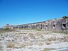 | May 31, 1972 (#72000096) | State Road 399 west of Pensacola Beach 30°19′20″N 87°16′36″W / 30.322222°N 87.276667°W / 30.322222; -87.276667 (Fort Pickens) | Pensacola Beach | |
| 13 | Hickory Ridge Cemetery Archeological Site | Upload image | September 22, 2000 (#00001131) | Address Restricted | Pensacola | |
| 14 | Hyer-Knowles Planing Mill Chimney | 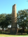 | May 24, 2012 (#12000299) | Junction of Scenic Bluffs Highway and Langley Ave. 30°28′50″N 87°09′45″W / 30.48064°N 87.16251°W / 30.48064; -87.16251 (Hyer-Knowles Planing Mill Chimney) | Pensacola | |
| 15 | James House |  | December 13, 2000 (#00001501) | 1606 North Martin Luther King Boulevard 30°25′55″N 87°12′49″W / 30.431944°N 87.213611°W / 30.431944; -87.213611 (James House) | Pensacola | |
| 16 | Charles William Jones House |  | December 20, 1977 (#77000403) | 302 North Barcelona Street 30°24′58″N 87°13′12″W / 30.416111°N 87.22°W / 30.416111; -87.22 (Charles William Jones House) | Pensacola | |
| 17 | King-Hooton House |  | August 23, 1991 (#91001090) | 512-514 North 7th Avenue 30°25′13″N 87°12′31″W / 30.420278°N 87.208611°W / 30.420278; -87.208611 (King-Hooton House) | Pensacola | |
| 18 | L & N Marine Terminal Building |  | August 14, 1972 (#72000315) | Commendencia Street Wharf 30°24′28″N 87°12′41″W / 30.407778°N 87.211389°W / 30.407778; -87.211389 (L & N Marine Terminal Building) | Pensacola | |
| 19 | Lavalle House |  | March 11, 1971 (#71000237) | 203 East Church Street 30°24′32″N 87°12′44″W / 30.408889°N 87.212222°W / 30.408889; -87.212222 (Lavalle House) | Pensacola | |
| 20 | Louisville and Nashville Passenger Station and Express Building |  | June 11, 1979 (#79000670) | 239 North Alcaniz Street 30°25′02″N 87°12′36″W / 30.417222°N 87.21°W / 30.417222; -87.21 (Louisville and Nashville Passenger Station and Express Building) | Pensacola | |
| 21 | Marzoni House |  | May 10, 2016 (#16000245) | 714 La Rua St. 30°25′13″N 87°12′29″W / 30.420184°N 87.207966°W / 30.420184; -87.207966 (Marzoni House) | Pensacola | |
| 22 | Motor Inn Number 2 | Upload image | September 27, 2022 (#100008234) | 500 West Jackson St. 30°25′07″N 87°13′25″W / 30.418478°N 87.223622°W / 30.418478; -87.223622 (Motor Inn Number 2) | Pensacola | |
| 23 | Mount Zion Missionary Baptist Church |  | December 24, 2013 (#13000963) | 528 West Jackson Street 30°25′05″N 87°13′28″W / 30.418124°N 87.224557°W / 30.418124; -87.224557 (Mount Zion Missionary Baptist Church) | Pensacola | |
| 24 | North Hill Preservation District |  | May 9, 1983 (#83001422) | Roughly bounded by Blount, Palafox, Wright, Belmont, Reus, and DeVilliers Streets 30°25′14″N 87°13′14″W / 30.420556°N 87.220556°W / 30.420556; -87.220556 (North Hill Preservation District) | Pensacola | |
| 25 | Old Christ Church |  | May 3, 1974 (#74000621) | 405 South Adams Street 30°24′33″N 87°12′38″W / 30.409167°N 87.210556°W / 30.409167; -87.210556 (Old Christ Church) | Pensacola | |
| 26 | Palafox Historic District | 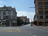 | April 27, 2016 (#14001085) | Palafox St. between Main & Chase extending to Spring 30°24′37″N 87°12′53″W / 30.4104°N 87.2147°W / 30.4104; -87.2147 (Palafox Historic District) | Pensacola | |
| 27 | Pensacola Harbor Defense Project |  | May 15, 2017 (#100000992) | W. end of Santa Rosa Island 30°19′27″N 87°16′40″W / 30.324119°N 87.277746°W / 30.324119; -87.277746 (Pensacola Harbor Defense Project) | Pensacola | |
| 28 | Pensacola Historic District | 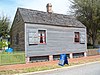 | September 29, 1970 (#70000184) | Address Unknown 30°24′38″N 87°12′36″W / 30.410556°N 87.21°W / 30.410556; -87.21 (Pensacola Historic District) | Pensacola | |
| 29 | Pensacola Hospital | 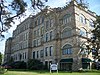 | February 16, 1982 (#82002373) | North 12th Avenue 30°25′34″N 87°12′10″W / 30.426111°N 87.202778°W / 30.426111; -87.202778 (Pensacola Hospital) | Pensacola | |
| 30 | Pensacola Lighthouse and Keeper's Quarters |  | July 15, 1974 (#74000622) | Naval Air Station Pensacola 30°20′44″N 87°18′29″W / 30.345556°N 87.308056°W / 30.345556; -87.308056 (Pensacola Lighthouse and Keeper's Quarters) | Pensacola | |
| 31 | Pensacola Naval Air Station Historic District | 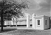 | December 8, 1976 (#76000595) | Naval Air Station Pensacola 30°20′47″N 87°16′09″W / 30.346389°N 87.269167°W / 30.346389; -87.269167 (Pensacola Naval Air Station Historic District) | Pensacola | |
| 32 | Perdido Key Historic District |  | March 10, 1980 (#80000404) | South of Warrington 30°19′32″N 87°19′34″W / 30.325556°N 87.326111°W / 30.325556; -87.326111 (Perdido Key Historic District) | Warrington | |
| 33 | Plaza Ferdinand VII |  | October 15, 1966 (#66000264) | Palafox Street between Government and Zaragossa Streets 30°24′33″N 87°12′50″W / 30.409167°N 87.213889°W / 30.409167; -87.213889 (Plaza Ferdinand VII) | Pensacola | |
| 34 | Sacred Heart Catholic Church |  | December 10, 2008 (#08001161) | 716 North 9th Avenue 30°25′13″N 87°12′23″W / 30.420278°N 87.206389°W / 30.420278; -87.206389 (Sacred Heart Catholic Church) | Pensacola | |
| 35 | Saenger Theatre | 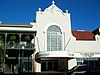 | July 19, 1976 (#76000596) | 118 South Palafox Street 30°24′37″N 87°12′53″W / 30.410278°N 87.214722°W / 30.410278; -87.214722 (Saenger Theatre) | Pensacola | |
| 36 | St. Joseph's Church Buildings |  | July 10, 1979 (#79000671) | 140 West Government Street 30°24′33″N 87°13′05″W / 30.409167°N 87.218056°W / 30.409167; -87.218056 (St. Joseph's Church Buildings) | Pensacola | |
| 37 | St. Michael's Creole Benevolent Association Hall | 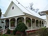 | May 3, 1974 (#74000623) | 416 East Government Street 30°24′37″N 87°12′33″W / 30.410278°N 87.209167°W / 30.410278; -87.209167 (St. Michael's Creole Benevolent Association Hall) | Pensacola | |
| 38 | Thiesen Building |  | December 13, 1979 (#79000672) | 40 South Palafox Street 30°24′32″N 87°12′38″W / 30.408889°N 87.210556°W / 30.408889; -87.210556 (Thiesen Building) | Pensacola | |
| 39 | United States Post Office and Court House | 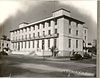 | July 11, 2014 (#14000389) | 100 N. Palafox St. 30°24′52″N 87°12′56″W / 30.414569°N 87.215631°W / 30.414569; -87.215631 (United States Post Office and Court House) | Pensacola | |
| 40 | US Customs House and Post Office |  | July 22, 1997 (#97000659) | 223 Palafox Place 30°24′34″N 87°12′54″W / 30.409444°N 87.215°W / 30.409444; -87.215 (US Customs House and Post Office) | Pensacola | |
| 41 | USS MASSACHUSETTS-BB-2 (shipwreck) | 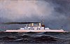 | May 31, 2001 (#01000528) | 1-mile (1.6 km) south-southwest of Pensacola Pass 30°17′45″N 87°18′45″W / 30.295833°N 87.3125°W / 30.295833; -87.3125 (USS MASSACHUSETTS-BB-2 (shipwreck)) | Pensacola | |
| 42 | P.K. Yonge House |  | October 16, 2018 (#100003019) | 1924 E Jackson St. 30°25′26″N 87°11′27″W / 30.4239°N 87.1907°W / 30.4239; -87.1907 (P.K. Yonge House) | Pensacola |
Former listings
| [3] | Name on the Register | Image | Date listed | Date removed | Location | City or town | Description |
|---|---|---|---|---|---|---|---|
| 1 | Buccaneer |  | November 2, 1972 (#72000313) | February 17, 1988 | Municipal Wharf | Pensacola | Also known as the Virginia.[6] Sank on August 10, 1977. |
| 2 | Pensacola Athletic Club | Upload image | April 16, 1975 (#75000552) | October 10, 1990 | SW corner of Baylen and Belmont Sts. | Pensacola | Also known as Rafford Hall. Destroyed by arsonist in 1990.[6] |
| 3 | San Carlos Hotel |  | January 20, 1982 (#82002374) | February 4, 1994 | 1 N Palafox St. | Pensacola | Demolished in 1993 |
See also
Wikimedia Commons has media related to National Register of Historic Places in Escambia County, Florida.
- List of National Historic Landmarks in Florida
- National Register of Historic Places listings in Florida
References
- ^ The latitude and longitude information provided in this table was derived originally from the National Register Information System, which has been found to be fairly accurate for about 99% of listings. Some locations in this table may have been corrected to current GPS standards.
- ^ National Park Service, United States Department of the Interior, "National Register of Historic Places: Weekly List Actions", retrieved April 26, 2024.
- ^ a b Numbers represent an alphabetical ordering by significant words. Various colorings, defined here, differentiate National Historic Landmarks and historic districts from other NRHP buildings, structures, sites or objects.
- ^ "National Register Information System". National Register of Historic Places. National Park Service. March 13, 2009.
- ^ The eight-digit number below each date is the number assigned to each location in the National Register Information System database, which can be viewed by clicking the number.
- ^ a b Phase I Environmental Site Assessment
- v
- t
- e
by county
- Alachua
- Baker
- Bay
- Bradford
- Brevard
- Broward
- Calhoun
- Charlotte
- Citrus
- Clay
- Collier
- Columbia
- DeSoto
- Dixie
- Duval
- Escambia
- Flagler
- Franklin
- Gadsden
- Gilchrist
- Glades
- Gulf
- Hamilton
- Hardee
- Hendry
- Hernando
- Highlands
- Hillsborough
- Holmes
- Indian River
- Jackson
- Jefferson
- Lake
- Lee
- Leon
- Levy
- Liberty
- Madison
- Manatee
- Marion
- Martin
- Miami-Dade
- Monroe
- Nassau
- Okaloosa
- Okeechobee
- Orange
- Osceola
- Palm Beach
- Pasco
- Pinellas
- Polk
- Putnam
- Santa Rosa
- Sarasota
- Seminole
- St. Johns
- St. Lucie
- Sumter
- Suwannee
- Taylor
- Union
- Volusia
- Wakulla
- Walton
- Washington

Municipalities and communities of Escambia County, Florida, United States | ||
|---|---|---|
County seat: Pensacola | ||
| City |  | |
| Town | ||
| CDPs | ||
| Unincorporated communities | ||
| Ghost town | ||
| Indian reservation | ||
| Footnotes | ‡This populated place also has portions in an adjacent county or counties | |
| ||


