National Register of Historic Places listings in Volusia County, Florida
This is a list of the National Register of Historic Places listings in Volusia County, Florida.
This is intended to be a complete list of the properties and districts on the National Register of Historic Places in Volusia County, Florida, United States. The locations of National Register properties and districts for which the latitude and longitude coordinates are included below, may be seen in a map.[1]
There are 109 properties and districts listed on the National Register in the county, including 2 National Historic Landmarks. Another district was once listed but has been removed.
This National Park Service list is complete through NPS recent listings posted April 26, 2024.[2]
Map all coordinates using OpenStreetMap
Download coordinates as:
- KML
- GPX (all coordinates)
- GPX (primary coordinates)
- GPX (secondary coordinates)
| Alachua - Baker - Bay - Bradford - Brevard - Broward - Calhoun - Charlotte - Citrus - Clay - Collier - Columbia - DeSoto - Dixie - Duval - Escambia - Flagler - Franklin - Gadsden - Gilchrist - Glades - Gulf - Hamilton - Hardee - Hendry - Hernando - Highlands - Hillsborough (Tampa) - Holmes - Indian River - Jackson - Jefferson - Lafayette - Lake - Lee - Leon - Levy - Liberty - Madison - Manatee - Marion - Martin - Miami-Dade (Miami) - Monroe - Nassau - Okaloosa - Okeechobee - Orange - Osceola - Palm Beach - Pasco - Pinellas - Polk - Putnam - St. Johns - St. Lucie - Santa Rosa - Sarasota - Seminole - Sumter - Suwannee - Taylor - Union - Volusia - Wakulla - Walton - Washington |
Current listings
| [3] | Name on the Register[4] | Image | Date listed[5] | Location | City or town | Description |
|---|---|---|---|---|---|---|
| 1 | The Abbey | 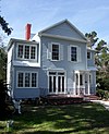 | April 9, 1987 (#87000615) | 426 South Beach Street 29°12′17″N 81°01′01″W / 29.204722°N 81.016944°W / 29.204722; -81.016944 (The Abbey) | Daytona Beach | |
| 2 | Airport Clear Zone Archeological Site | Upload image | July 10, 2008 (#08000639) | Address Restricted | New Smyrna Beach | Part of the Archeological Resources of the 18th-Century Smyrnea Settlement of Dr. Andrew Turnbull MPS |
| 3 | All Saint's Episcopal Church |  | May 3, 1974 (#74000656) | Corner of DeBary Avenue Northeast and Clark Street 28°52′10″N 81°16′10″W / 28.869444°N 81.269444°W / 28.869444; -81.269444 (All Saint's Episcopal Church) | Enterprise | |
| 4 | Anderson–Price Memorial Library Building |  | January 26, 1984 (#84000967) | 42 North Beach Street 29°17′12″N 81°03′23″W / 29.286667°N 81.056389°W / 29.286667; -81.056389 (Anderson–Price Memorial Library Building) | Ormond Beach | |
| 5 | Barberville Central High School |  | February 3, 1993 (#92001838) | 1776 Lightfoot Lane 29°11′00″N 81°25′23″W / 29.183333°N 81.423056°W / 29.183333; -81.423056 (Barberville Central High School) | Barberville | |
| 6 | Mary McLeod Bethune Home |  | December 2, 1974 (#74000655) | Bethune-Cookman College campus 29°12′45″N 81°01′56″W / 29.2125°N 81.032222°W / 29.2125; -81.032222 (Mary McLeod Bethune Home) | Daytona Beach | Home of educator and civil rights leader Mary McLeod Bethune |
| 7 | Bethune–Cookman College Historic District |  | March 21, 1996 (#96000298) | 620 Dr. Mary McLeod Bethune Boulevard 29°12′43″N 81°01′55″W / 29.211944°N 81.031944°W / 29.211944; -81.031944 (Bethune–Cookman College Historic District) | Daytona Beach | Part of the Daytona Beach MPS |
| 8 | Blanchette Archeological Site | Upload image | July 10, 2008 (#08000640) | Address Restricted | New Smyrna Beach | Part of the Archeological Resources of the 18th-Century Smyrnea Settlement of Dr. Andrew Turnbull MPS |
| 9 | Delos A. Blodgett House |  | August 2, 1993 (#93000724) | 404 Ridgewood Avenue 29°12′16″N 81°01′13″W / 29.204444°N 81.020278°W / 29.204444; -81.020278 (Delos A. Blodgett House) | Daytona Beach | |
| 10 | Casements Annex |  | October 6, 1988 (#88001720) | 127 Riverside Drive 29°17′07″N 81°02′45″W / 29.285278°N 81.045833°W / 29.285278; -81.045833 (Casements Annex) | Ormond Beach | Part of the Historic Winter Residences of Ormond Beach, 1878-1925 MPS |
| 11 | The Casements |  | June 30, 1972 (#72001536) | 15 East Granada Avenue 29°17′21″N 81°02′45″W / 29.289167°N 81.045833°W / 29.289167; -81.045833 (The Casements) | Ormond Beach | |
| 12 | Chief Master at Arms House |  | February 15, 2002 (#02000003) | 910 Biscayne Boulevard 29°03′29″N 81°17′18″W / 29.058056°N 81.288333°W / 29.058056; -81.288333 (Chief Master at Arms House) | DeLand | Part of the Florida's Historic World War II Military Resources MPS |
| 13 | City Island |  | January 7, 2000 (#99001646) | 108 East Orange Avenue 29°12′34″N 81°00′58″W / 29.209444°N 81.016111°W / 29.209444; -81.016111 (City Island) | Daytona Beach | |
| 14 | City Island Ball Park |  | October 22, 1998 (#98001253) | City Island, across from the Daytona Beach business district 29°12′34″N 81°01′00″W / 29.209444°N 81.016667°W / 29.209444; -81.016667 (City Island Ball Park) | Daytona Beach | Part of the Daytona Beach MPS |
| 15 | Coronado Historic District | 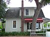 | February 21, 1997 (#97000098) | Roughly bounded by Columbus, Due East, and Pine Avenues, and the Indian River 29°02′19″N 80°54′10″W / 29.038611°N 80.902778°W / 29.038611; -80.902778 (Coronado Historic District) | New Smyrna Beach | |
| 16 | Cypress Street Elementary School | 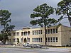 | December 2, 1996 (#96001333) | 868 West George W Engram Boulevard 29°12′46″N 81°02′24″W / 29.212778°N 81.04°W / 29.212778; -81.04 (Cypress Street Elementary School) | Daytona Beach | Part of the Daytona Beach MPS |
| 17 | Daytona Beach Bandshell and Oceanfront Park Complex |  | March 5, 1999 (#99000159) | Ocean Avenue, north of the junction of Main Street and Atlantic 29°13′41″N 81°00′29″W / 29.228056°N 81.008056°W / 29.228056; -81.008056 (Daytona Beach Bandshell and Oceanfront Park Complex) | Daytona Beach | Part of the Daytona Beach MPS |
| 18 | Daytona Beach Surfside Historic District |  | August 1, 1996 (#96000851) | Roughly bounded by Auditorium Boulevard, the Atlantic Ocean, U.S. Route 92, and the Halifax River 29°13′30″N 81°00′36″W / 29.225°N 81.01°W / 29.225; -81.01 (Daytona Beach Surfside Historic District) | Daytona Beach | Part of the Daytona Beach MPS |
| 19 | DeBary Hall |  | July 24, 1972 (#72000354) | DeBary Mansion State Park 28°52′29″N 81°17′50″W / 28.874722°N 81.297222°W / 28.874722; -81.297222 (DeBary Hall) | DeBary | |
| 20 | DeLand Hall |  | January 27, 1983 (#83001441) | Stetson University campus 29°02′06″N 81°18′12″W / 29.035°N 81.303333°W / 29.035; -81.303333 (DeLand Hall) | DeLand | |
| 21 | DeLeon Springs Colored School |  | August 1, 2003 (#03000702) | 330 East Retta Street 29°06′51″N 81°20′51″W / 29.114167°N 81.3475°W / 29.114167; -81.3475 (DeLeon Springs Colored School) | DeLeon Springs | Part of the Florida's Historic Black Public Schools MPS |
| 22 | Dickinson Memorial Library and Park |  | February 8, 1995 (#95000020) | 148 South Volusia Avenue (US 17) 28°56′52″N 81°17′55″W / 28.947778°N 81.298611°W / 28.947778; -81.298611 (Dickinson Memorial Library and Park) | Orange City | |
| 23 | Dix House |  | September 6, 1989 (#88001721) | 178 North Beach Street 29°17′25″N 81°03′28″W / 29.290278°N 81.057778°W / 29.290278; -81.057778 (Dix House) | Ormond Beach | Part of the Historic Winter Residences of Ormond Beach, 1878-1925 MPS |
| 24 | Bartholomew J. Donnelly House |  | August 2, 1993 (#93000726) | 801 North Peninsula Drive 29°14′16″N 81°01′10″W / 29.237778°N 81.019444°W / 29.237778; -81.019444 (Bartholomew J. Donnelly House) | Daytona Beach | |
| 25 | Downtown DeLand Historic District |  | December 23, 1987 (#87001796) | Roughly bounded by Florida and Rich Avenues, Woodland Boulevard, and Howry Avenue 29°01′39″N 81°18′17″W / 29.0275°N 81.304722°W / 29.0275; -81.304722 (Downtown DeLand Historic District) | DeLand | |
| 26 | Dunlawton Avenue Historic District |  | February 5, 1998 (#98000055) | Roughly along Dunlawton Avenue to Lafayette Avenue, and Orange Avenue and Wellman Street 29°08′32″N 80°59′29″W / 29.142222°N 80.991389°W / 29.142222; -80.991389 (Dunlawton Avenue Historic District) | Port Orange | Part of the Port Orange MPS |
| 27 | Dunlawton Plantation-Sugar Mill Ruins |  | August 28, 1973 (#73000606) | 950 Old Sugar Mill Road 29°08′29″N 81°00′26″W / 29.141389°N 81.007222°W / 29.141389; -81.007222 (Dunlawton Plantation-Sugar Mill Ruins) | Port Orange | |
| 28 | Eastwood Terrace Hotel |  | April 2, 2019 (#100003586) | 442 E. New York Ave. 29°01′40″N 81°17′43″W / 29.027735°N 81.295312°W / 29.027735; -81.295312 (Eastwood Terrace Hotel) | Deland | |
| 29 | El Pino Parque Historic District |  | April 26, 1993 (#93000318) | 1412-1604 North Halifax Drive 29°15′07″N 81°01′44″W / 29.251944°N 81.028889°W / 29.251944; -81.028889 (El Pino Parque Historic District) | Daytona Beach | |
| 30 | El Real Retiro |  | November 10, 1987 (#87001557) | 636 North Riverside Drive and 647 Faulkner Street 29°02′04″N 80°55′41″W / 29.034444°N 80.928056°W / 29.034444; -80.928056 (El Real Retiro) | New Smyrna Beach | |
| 31 | First Presbyterian Church Archeological Site |  | July 10, 2008 (#08000635) | 509 Magnolia Street[6] 29°01′16″N 80°55′12″W / 29.021000°N 80.920000°W / 29.021000; -80.920000 (First Presbyterian Church Archeological Site) | New Smyrna Beach | Part of the Archeological Resources of the 18th-Century Smyrnea Settlement of Dr. Andrew Turnbull MPS |
| 32 | Seth French House |  | February 12, 2003 (#03000005) | 319 East French Avenue 28°57′09″N 81°17′47″W / 28.952500°N 81.296389°W / 28.952500; -81.296389 (Seth French House) | Orange City | |
| 33 | Gamble Place Historic District |  | September 29, 1993 (#93000563) | 1819 Taylor Road 29°05′22″N 81°02′44″W / 29.089444°N 81.045556°W / 29.089444; -81.045556 (Gamble Place Historic District) | Port Orange | |
| 34 | Grace Episcopal Church and Guild Hall |  | February 5, 1998 (#98000058) | 4100 Ridgewood Avenue 29°08′35″N 80°59′14″W / 29.143056°N 80.987222°W / 29.143056; -80.987222 (Grace Episcopal Church and Guild Hall) | Port Orange | Part of the Port Orange MPS |
| 35 | Grange Archeological Site | Upload image | July 10, 2008 (#08000631) | Address Restricted | New Smyrna Beach | Part of the Archeological Resources of the 18th-Century Smyrnea Settlement of Dr. Andrew Turnbull MPS |
| 36 | Green Mound |  | June 4, 2020 (#100005243) | Ponce Preserve, 4400 South Peninsula Dr. 29°06′55″N 80°56′58″W / 29.1153°N 80.9494°W / 29.1153; -80.9494 (Green Mound) | Ponce Inlet | |
| 37 | The Hammocks |  | September 5, 1989 (#88001719) | 311 John Anderson Highway 29°17′51″N 81°03′06″W / 29.297500°N 81.051667°W / 29.297500; -81.051667 (The Hammocks) | Ormond Beach | Part of the Historic Winter Residences of Ormond Beach, 1878-1925 MPS |
| 38 | Hawks Archeological Site | Upload image | July 10, 2008 (#08000636) | Address Restricted | Edgewater | Part of the Archeological Resources of the 18th-Century Smyrnea Settlement of Dr. Andrew Turnbull MPS |
| 39 | Alexander Haynes House |  | September 7, 1995 (#95001070) | 128 West Howry Avenue 29°01′33″N 81°18′18″W / 29.025833°N 81.305°W / 29.025833; -81.305 (Alexander Haynes House) | DeLand | |
| 40 | Holly Hill Municipal Building |  | April 8, 1993 (#93000285) | 1065 Ridgewood Avenue 29°14′43″N 81°02′25″W / 29.2453°N 81.0403°W / 29.2453; -81.0403 (Holly Hill Municipal Building) | Holly Hill | |
| 41 | Janet's Archeological Site | Upload image | July 10, 2008 (#08000630) | Address Restricted | New Smyrna Beach | Part of the Archeological Resources of the 18th-Century Smyrnea Settlement of Dr. Andrew Turnbull MPS |
| 42 | Kilkoff House |  | October 8, 1997 (#97001216) | 1145 West New York Avenue 29°01′42″N 81°19′33″W / 29.0283°N 81.3258°W / 29.0283; -81.3258 (Kilkoff House) | DeLand | |
| 43 | Amos Kling House |  | December 2, 1993 (#93001353) | 220-222 Magnolia Avenue 29°12′34″N 81°01′18″W / 29.2094°N 81.0217°W / 29.2094; -81.0217 (Amos Kling House) | Daytona Beach | |
| 44 | S.H. Kress and Co. Building |  | July 7, 1983 (#83001442) | 140 South Beach Street 29°12′38″N 81°01′10″W / 29.2106°N 81.0194°W / 29.2106; -81.0194 (S.H. Kress and Co. Building) | Daytona Beach | |
| 45 | Lake Helen Historic District |  | September 16, 1993 (#93000981) | Roughly bounded by West New York, Lakeview, Park, and Euclid Avenues 28°59′18″N 81°14′03″W / 28.9883°N 81.2342°W / 28.9883; -81.2342 (Lake Helen Historic District) | Lake Helen | Part of the Lake Helen MPS |
| 46 | Doris Leeper House |  | November 27, 2020 (#100005857) | 1/2 mi. south of Eldora Rd. in the Canaveral National Seashore 28°54′11″N 80°49′02″W / 28.90314°N 80.81732°W / 28.90314; -80.81732 (Doris Leeper House) | New Smyrna Beach | |
| 47 | Lippincott Mansion |  | February 21, 1985 (#85000304) | 150 South Beach Street 29°16′51″N 81°03′15″W / 29.2808°N 81.0542°W / 29.2808; -81.0542 (Lippincott Mansion) | Ormond Beach | |
| 48 | Merchants Bank Building |  | January 6, 1986 (#86000025) | 252 South Beach Street 29°12′30″N 81°00′29″W / 29.2083°N 81.0081°W / 29.2083; -81.0081 (Merchants Bank Building) | Daytona Beach | |
| 49 | Meyer–Davis House–Hasty Cottage |  | November 16, 2015 (#15000786) | 143 Beach St. 29°04′57″N 80°56′02″W / 29.0825°N 80.9339°W / 29.0825; -80.9339 (Meyer–Davis House–Hasty Cottage) | Ponce Inlet | |
| 50 | Moulton–Wells House |  | November 21, 2001 (#01001247) | West of Eldora Road on the Canaveral National Seashore 28°54′32″N 80°49′16″W / 28.9089°N 80.8211°W / 28.9089; -80.8211 (Moulton–Wells House) | New Smyrna Beach | |
| 51 | Mount Taylor | Upload image | October 8, 1997 (#97001219) | Address Restricted | DeBary | |
| 52 | New Smyrna Beach Historic District |  | April 26, 1990 (#90000714) | Roughly bounded by Riverside Drive, U.S. Route 1, Ronnoc Lane, and Smith Street 29°01′30″N 80°55′27″W / 29.025°N 80.9242°W / 29.025; -80.9242 (New Smyrna Beach Historic District) | New Smyrna Beach | |
| 53 | New Smyrna Sugar Mill Ruins |  | August 12, 1970 (#70000192) | 600 Old Mission Road 29°00′34″N 80°56′25″W / 29.0094°N 80.9403°W / 29.0094; -80.9403 (New Smyrna Sugar Mill Ruins) | New Smyrna Beach | |
| 54 | Nocoroco |  | May 7, 1973 (#73000605) | 2 miles north of Ormond Beach 29°21′07″N 81°05′14″W / 29.3519°N 81.0872°W / 29.3519; -81.0872 (Nocoroco) | Ormond Beach | |
| 55 | Old DeLand Memorial Hospital |  | November 27, 1989 (#89002030) | Stone Street 29°02′37″N 81°19′03″W / 29.0436°N 81.3175°W / 29.0436; -81.3175 (Old DeLand Memorial Hospital) | DeLand | |
| 56 | Old Fort Park Archeological Site |  | July 10, 2008 (#08000629) | Address Restricted 29°01′38″N 80°55′20″W / 29.0272°N 80.9222°W / 29.0272; -80.9222 (Old Fort Park Archeological Site) | New Smyrna Beach | Part of the Archeological Resources of the 18th-Century Smyrnea Settlement of Dr. Andrew Turnbull MPS |
| 57 | Old Stone Wharf Archeological Site |  | July 10, 2008 (#08000638) | Address Restricted 29°01′11″N 80°55′07″W / 29.0197°N 80.9186°W / 29.0197; -80.9186 (Old Stone Wharf Archeological Site) | New Smyrna Beach | Part of the Archeological Resources of the 18th-Century Smyrnea Settlement of Dr. Andrew Turnbull MPS |
| 58 | Olds Hall |  | September 23, 1993 (#93001003) | 340 South Ridgewood Avenue 29°12′18″N 81°01′13″W / 29.205°N 81.0203°W / 29.205; -81.0203 (Olds Hall) | Daytona Beach | |
| 59 | Orange City Colored School |  | August 1, 2003 (#03000703) | 200 East Blue Springs Avenue 28°56′19″N 81°17′49″W / 28.9386°N 81.2969°W / 28.9386; -81.2969 (Orange City Colored School) | Orange City | Part of the Florida's Historic Black Public Schools MPS |
| 60 | Orange City Historic District |  | April 6, 2004 (#04000265) | Roughly Banana, Carpenter, French and Orange Avenues 28°56′56″N 81°17′57″W / 28.9489°N 81.2992°W / 28.9489; -81.2992 (Orange City Historic District) | Orange City | Part of the Orange City, Florida MPS |
| 61 | Orange City Town Hall |  | May 16, 2002 (#02000493) | 205 East Graves Avenue 28°56′56″N 81°17′52″W / 28.9489°N 81.2978°W / 28.9489; -81.2978 (Orange City Town Hall) | Orange City | |
| 62 | Ormond Fire House |  | December 15, 2010 (#10001033) | 160 East Granada Boulevard 29°17′27″N 81°02′32″W / 29.2908°N 81.0422°W / 29.2908; -81.0422 (Ormond Fire House) | Ormond Beach | |
| 63 | Ormond Hotel | 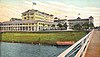 | November 24, 1980 (#80000964) | 15 East Granada Boulevard 29°17′22″N 81°02′50″W / 29.2894°N 81.0472°W / 29.2894; -81.0472 (Ormond Hotel) | Ormond Beach | Demolished in 1992, only hotel's cupola preserved in nearby park[7] |
| 64 | Ormond Yacht Club |  | April 19, 2005 (#05000310) | 63 North Beach Street 29°17′16″N 81°03′21″W / 29.2878°N 81.0558°W / 29.2878; -81.0558 (Ormond Yacht Club) | Ormond Beach | |
| 65 | Pacetti Hotel | Upload image | November 23, 2020 (#100005822) | 4928 South Peninsula Dr. 29°04′51″N 80°55′45″W / 29.0807°N 80.9293°W / 29.0807; -80.9293 (Pacetti Hotel) | Ponce Inlet | |
| 66 | Persimmon Mound |  | April 14, 1994 (#94000357) | Baxter Point Road on the northern side of the St. Johns River[8]: 5 28°36′56″N 80°58′12″W / 28.6156°N 80.9700°W / 28.6156; -80.9700 (Persimmon Mound) | Rockledge | Originally recorded as being a short distance away in Brevard County[8]: 4 |
| 67 | Ponce De Leon Inlet Lightstation | 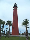 | September 22, 1972 (#72000355) | 4931 South Peninsula Drive, U.S. Coast Guard Reservation 29°04′50″N 80°55′42″W / 29.0806°N 80.9283°W / 29.0806; -80.9283 (Ponce De Leon Inlet Lightstation) | Ponce Inlet | |
| 68 | The Porches |  | October 6, 1988 (#88001715) | 176 South Beach Street 29°16′52″N 81°03′14″W / 29.2811°N 81.0539°W / 29.2811; -81.0539 (The Porches) | Ormond Beach | Part of the Historic Winter Residences of Ormond Beach, 1878-1925 MPS |
| 69 | Port Orange Florida East Coast Railway Freight Depot |  | February 5, 1998 (#98000057) | 415C Herbert Street 29°08′37″N 80°59′36″W / 29.1436°N 80.9933°W / 29.1436; -80.9933 (Port Orange Florida East Coast Railway Freight Depot) | Port Orange | Part of the Port Orange MPS |
| 70 | Rogers House |  | September 11, 1986 (#86002407) | 436 North Beach Street 29°13′09″N 81°00′50″W / 29.2192°N 81.0139°W / 29.2192; -81.0139 (Rogers House) | Daytona Beach | |
| 71 | Ross Hammock Site | Upload image | February 5, 1981 (#81000083) | Address Restricted | Oak Hill | |
| 72 | Rowallan |  | October 6, 1988 (#88001724) | 253 John Anderson Highway 29°17′36″N 81°02′59″W / 29.2933°N 81.0497°W / 29.2933; -81.0497 (Rowallan) | Ormond Beach | Part of the Historic Winter Residences of Ormond Beach, 1878-1925 MPS |
| 73 | St. Rita's Colored Catholic Mission |  | April 13, 2007 (#07000280) | 314 Duss Street 29°01′27″N 80°55′56″W / 29.0242°N 80.9322°W / 29.0242; -80.9322 (St. Rita's Colored Catholic Mission) | New Smyrna Beach | |
| 74 | Seabreeze Historic District |  | September 3, 1998 (#98001131) | Roughly bounded by University Boulevard, the Halifax River, Auditorium Boulevard, and North Atlantic Avenue 29°13′58″N 81°02′34″W / 29.2328°N 81.0428°W / 29.2328; -81.0428 (Seabreeze Historic District) | Daytona Beach | Part of the Daytona Beach MPS |
| 75 | Seminole Rest |  | March 19, 1997 (#97000231) | East of State Road 5 on the western shore of Mosquito Lagoon at the Canaveral National Seashore 28°52′11″N 80°50′15″W / 28.8697°N 80.8375°W / 28.8697; -80.8375 (Seminole Rest) | Oak Hill | |
| 76 | Seybold Baking Company Factory |  | October 30, 1997 (#97001283) | 800 Orange Avenue 29°12′09″N 81°01′55″W / 29.2025°N 81.0319°W / 29.2025; -81.0319 (Seybold Baking Company Factory) | Daytona Beach | Part of the Daytona Beach MPS |
| 77 | Sleepy Hollow Archeological Site | Upload image | July 10, 2008 (#08000637) | Address Restricted | New Smyrna Beach | Part of the Archeological Resources of the 18th-Century Smyrnea Settlement of Dr. Andrew Turnbull MPS |
| 78 | South Beach Street Historic District |  | September 15, 1988 (#88001597) | Roughly bounded by Volusia Avenue, South Beach Street, South Street, and U.S. Route 1 29°12′18″N 81°01′03″W / 29.205°N 81.0175°W / 29.205; -81.0175 (South Beach Street Historic District) | Daytona Beach | |
| 79 | South Peninsula Historic District |  | November 19, 1998 (#98001379) | Roughly the Daytona Beach Peninsula between the Atlantic Ocean and the Halifax River 29°12′37″N 81°00′20″W / 29.2103°N 81.0056°W / 29.2103; -81.0056 (South Peninsula Historic District) | Daytona Beach | Part of the Daytona Beach MPS |
| 80 | South Ridgewood Elementary School |  | July 14, 2011 (#11000436) | 747 S. Ridgewood Ave. 29°11′55″N 81°00′56″W / 29.1986°N 81.0156°W / 29.1986; -81.0156 (South Ridgewood Elementary School) | Daytona Beach | |
| 81 | Southern Cassadaga Spiritualist Camp Historic District |  | March 14, 1991 (#91000249) | Roughly bounded by Cassadaga Road and Marion, Stevens, Lake, and Chauncey Streets 28°57′52″N 81°14′14″W / 28.9644°N 81.2372°W / 28.9644; -81.2372 (Southern Cassadaga Spiritualist Camp Historic District) | Cassadaga | |
| 82 | Southwest Daytona Beach Black Heritage District |  | May 23, 1997 (#97000457) | Roughly bounded by Foote Court, South Street, Dr. Martin Luther King Boulevard, and the Florida East Coast railroad tracks 29°12′08″N 81°01′26″W / 29.2022°N 81.0239°W / 29.2022; -81.0239 (Southwest Daytona Beach Black Heritage District) | Daytona Beach | Part of the Daytona Beach MPS |
| 83 | Spruce Creek Mound Complex |  | December 3, 1990 (#90001761) | Address Restricted | Port Orange | |
| 84 | Stetson University Campus Historic District |  | March 14, 1991 (#91000244) | Roughly bounded by Michigan Avenue, North Florida Avenue, West University Avenue, and a line south from North Hayden Avenue 29°02′06″N 81°18′13″W / 29.035°N 81.3036°W / 29.035; -81.3036 (Stetson University Campus Historic District) | DeLand | |
| 85 | John B. Stetson House |  | November 21, 1978 (#78000957) | 1031 Camphor Lane 29°01′24″N 81°19′25″W / 29.0233°N 81.3236°W / 29.0233; -81.3236 (John B. Stetson House) | DeLand | |
| 86 | Ann Stevens House |  | August 18, 1993 (#93000734) | 201 East Kicklighter Road 28°58′10″N 81°14′00″W / 28.9694°N 81.2333°W / 28.9694; -81.2333 (Ann Stevens House) | Lake Helen | Part of the Lake Helen MPS |
| 87 | Stockton-Lindquist House |  | June 22, 2004 (#04000626) | 244 East Beresford Avenue 29°00′48″N 81°17′59″W / 29.0133°N 81.2997°W / 29.0133; -81.2997 (Stockton-Lindquist House) | DeLand | |
| 88 | Strawn Historic Agricultural District | 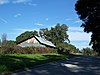 | September 13, 1993 (#93000929) | Bounded by Broderick and Retta Streets and by Central and Dundee Avenues 29°06′56″N 81°20′56″W / 29.1156°N 81.3489°W / 29.1156; -81.3489 (Strawn Historic Agricultural District) | DeLeon Springs | Part of the Citrus Industry Resources of Theodore Strawn, Inc., MPS |
| 89 | Strawn Historic Citrus Packing House District |  | September 13, 1993 (#93000931) | 5707 Lake Winona Road 29°08′18″N 81°21′35″W / 29.1383°N 81.3597°W / 29.1383; -81.3597 (Strawn Historic Citrus Packing House District) | DeLeon Springs | Part of the Citrus Industry Resources of Theodore Strawn, Inc., MPS |
| 90 | Strawn Historic Sawmill District |  | September 13, 1993 (#93000930) | 5710 Lake Winona Road 29°08′21″N 81°21′38″W / 29.1392°N 81.3606°W / 29.1392; -81.3606 (Strawn Historic Sawmill District) | DeLeon Springs | Part of the Citrus Industry Resources of Theodore Strawn, Inc., MPS |
| 91 | Talahloka |  | September 6, 1989 (#88001716) | 19 Orchard Lane 29°17′26″N 81°02′53″W / 29.2906°N 81.0481°W / 29.2906; -81.0481 (Talahloka) | Ormond Beach | Part of the Historic Winter Residences of Ormond Beach, 1878-1925 MPS |
| 92 | Tarragona Tower |  | May 6, 2005 (#05000368) | Tarragona Way and International Speedway Boulevard 29°12′00″N 81°02′49″W / 29.2°N 81.0469°W / 29.2; -81.0469 (Tarragona Tower) | Daytona Beach | |
| 93 | Three Chimneys Archaeological Site |  | September 16, 2010 (#10000757) | 715 West Granada Boulevard 29°16′41″N 81°04′26″W / 29.2780°N 81.0740°W / 29.2780; -81.0740 (Three Chimneys Archaeological Site) | Ormond Beach | |
| 94 | Howard Thurman House |  | February 23, 1990 (#90000100) | 614 Whitehall Street 29°11′54″N 81°01′19″W / 29.1983°N 81.0219°W / 29.1983; -81.0219 (Howard Thurman House) | Daytona Beach | Home of educator and civil rights leader Howard Thurman |
| 95 | Louis P. Thursby House |  | May 11, 2000 (#00000468) | Located inside Blue Spring State Park 28°56′41″N 81°20′21″W / 28.9447°N 81.3392°W / 28.9447; -81.3392 (Louis P. Thursby House) | Orange City | |
| 96 | Tomoka Mound and Midden Complex | Upload image | November 27, 2020 (#100005821) | Address Restricted | Ormond Beach | |
| 97 | Tourist Church |  | October 6, 1995 (#95001139) | 501 North Wild Olive Avenue 29°13′59″N 81°00′52″W / 29.2331°N 81.0144°W / 29.2331; -81.0144 (Tourist Church) | Daytona Beach | |
| 98 | Turnbull Canal System |  | August 24, 2007 (#07000840) | Address Restricted | New Smyrna Beach | Part of the Archeological Resources of the 18th-Century Smyrnea Settlement of Dr. Andrew Turnbull MPS |
| 99 | Turnbull Colonists' House Archeological Site |  | July 10, 2008 (#08000632) | 1919 North Dixie Freeway 29°03′17″N 80°56′23″W / 29.0547°N 80.9397°W / 29.0547; -80.9397 (Turnbull Colonists' House Archeological Site) | New Smyrna Beach | Part of the Archeological Resources of the 18th-Century Smyrnea Settlement of Dr. Andrew Turnbull MPS |
| 100 | Turnbull Colonists' House No. 2 Archeological Site | Upload image | July 10, 2008 (#08000633) | Address Restricted | New Smyrna Beach | Part of the Archeological Resources of the 18th-Century Smyrnea Settlement of Dr. Andrew Turnbull MPS |
| 101 | Turtle Mound | 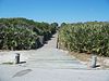 | September 29, 1970 (#70000193) | Canaveral National Seashore, south of Bethune Beach[9] 28°55′51″N 80°49′37″W / 28.9308°N 80.8269°W / 28.9308; -80.8269 (Turtle Mound) | New Smyrna Beach | |
| 102 | US Post Office |  | June 30, 1988 (#88000974) | 220 North Beach Street 29°12′53″N 81°01′16″W / 29.2146°N 81.0210°W / 29.2146; -81.0210 (US Post Office) | Daytona Beach | |
| 103 | Village Improvement Association Hall |  | October 7, 2022 (#100008277) | 126 East Halifax Ave. 28°51′51″N 80°51′01″W / 28.864278°N 80.850278°W / 28.864278; -80.850278 (Village Improvement Association Hall) | Oak Hill | |
| 104 | West DeLand Residential District |  | November 20, 1992 (#92001617) | Roughly bounded by University, Florida, New York and Orange Avenues 29°01′57″N 81°18′37″W / 29.0325°N 81.310278°W / 29.0325; -81.310278 (West DeLand Residential District) | DeLand | |
| 105 | White–Fox House Archeological Site | Upload image | July 10, 2008 (#08000634) | Address Restricted | New Smyrna Beach | Part of the Archeological Resources of the 18th-Century Smyrnea Settlement of Dr. Andrew Turnbull MPS |
| 106 | White Hall |  | July 15, 1992 (#92000849) | 640 Dr. Mary McLeod Bethune Boulevard 29°12′43″N 81°01′57″W / 29.211944°N 81.0325°W / 29.211944; -81.0325 (White Hall) | Daytona Beach | |
| 107 | Woman's Club of New Smyrna |  | May 11, 1989 (#89000410) | 403 Magnolia Street 29°01′20″N 80°55′16″W / 29.022222°N 80.921111°W / 29.022222; -80.921111 (Woman's Club of New Smyrna) | New Smyrna Beach | |
| 108 | James W. Wright Building |  | February 1, 2021 (#100006120) | 258 West Voorhis Ave. 29°01′28″N 81°18′26″W / 29.0245°N 81.3071°W / 29.0245; -81.3071 (James W. Wright Building) | DeLand | |
| 109 | S. Cornelia Young Memorial Library |  | June 25, 1992 (#92000823) | 302 Vermont Avenue 29°13′10″N 81°00′36″W / 29.219444°N 81.01°W / 29.219444; -81.01 (S. Cornelia Young Memorial Library) | Daytona Beach |
Former listing
| [3] | Name on the Register | Image | Date listed | Date removed | Location | City or town | Description |
|---|---|---|---|---|---|---|---|
| 1 | John Anderson Lodge |  | September 6, 1989 (#88001717) | August 22, 2023 | 71 Orchard Lane 29°17′26″N 81°02′50″W / 29.290556°N 81.047222°W / 29.290556; -81.047222 (John Anderson Lodge) | Ormond Beach | Part of the Historic Winter Residences of Ormond Beach, 1878-1925 MPS |
| 2 | Halifax Drive Historic District |  | February 5, 1998 (#98000056) | January 29, 2009 | Roughly along Halifax Drive from Dunlawton to Herbert Street 29°08′37″N 80°59′11″W / 29.1436°N 80.9864°W / 29.1436; -80.9864 (Halifax Drive Historic District) | Port Orange | Part of the Port Orange MPS |
| 3 | Ormond Garage |  | September 29, 1970 (#76002284) | January 19, 1976 | 79 E. Granada | Ormond Beach | Destroyed by fire in 1976.[10] |
See also
- List of National Historic Landmarks in Florida
- National Register of Historic Places listings in Florida
References
Wikimedia Commons has media related to National Register of Historic Places in Volusia County, Florida.
- ^ The latitude and longitude information provided in this table was derived originally from the National Register Information System, which has been found to be fairly accurate for about 99% of listings. Some locations in this table may have been corrected to current GPS standards.
- ^ National Park Service, United States Department of the Interior, "National Register of Historic Places: Weekly List Actions", retrieved April 26, 2024.
- ^ a b Numbers represent an alphabetical ordering by significant words. Various colorings, defined here, differentiate National Historic Landmarks and historic districts from other NRHP buildings, structures, sites or objects.
- ^ "National Register Information System". National Register of Historic Places. National Park Service. March 13, 2009.
- ^ The eight-digit number below each date is the number assigned to each location in the National Register Information System database, which can be viewed by clicking the number.
- ^ Location derived from the location of First Presbyterian Church from this Archived 2008-08-07 at the Wayback Machine Central Florida Presbytery webpage; the NRIS lists the site as "Address Restricted"
- ^ Ormond Beach: The pace slows at the 'Birthplace of Speed'
- ^ a b Newman, C., and B. Weisman. "Florida Site File Archaeological Site Form: Persimmon Mound/Baxter Mound". Florida Division of Historical Resources, 1992-10-16.
- ^ Location derived from its GNIS feature record; the NRIS lists the site as "Address Restricted"
- ^ Ormond Hotel Nomination Form
- v
- t
- e
by county
- Alachua
- Baker
- Bay
- Bradford
- Brevard
- Broward
- Calhoun
- Charlotte
- Citrus
- Clay
- Collier
- Columbia
- DeSoto
- Dixie
- Duval
- Escambia
- Flagler
- Franklin
- Gadsden
- Gilchrist
- Glades
- Gulf
- Hamilton
- Hardee
- Hendry
- Hernando
- Highlands
- Hillsborough
- Holmes
- Indian River
- Jackson
- Jefferson
- Lake
- Lee
- Leon
- Levy
- Liberty
- Madison
- Manatee
- Marion
- Martin
- Miami-Dade
- Monroe
- Nassau
- Okaloosa
- Okeechobee
- Orange
- Osceola
- Palm Beach
- Pasco
- Pinellas
- Polk
- Putnam
- Santa Rosa
- Sarasota
- Seminole
- St. Johns
- St. Lucie
- Sumter
- Suwannee
- Taylor
- Union
- Volusia
- Wakulla
- Walton
- Washington

Municipalities and communities of Volusia County, Florida, United States | ||
|---|---|---|
County seat: DeLand | ||
| Cities |  | |
| Towns | ||
| CDPs | ||
| Unincorporated communities | ||
| Ghost town | ||
| Footnotes | ‡This populated place also has portions in an adjacent county or counties | |
| ||


