National Register of Historic Places listings in Franklin County, Florida
This is a list of the National Register of Historic Places listings in Franklin County, Florida.
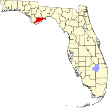
This is intended to be a complete list of the properties and districts on the National Register of Historic Places in Franklin County, Florida, United States. The locations of National Register properties and districts for which the latitude and longitude coordinates are included below, may be seen in a map.[1]
There are 9 properties and districts listed on the National Register in the county, including 1 National Historic Landmark.
This National Park Service list is complete through NPS recent listings posted April 26, 2024.[2]
Map all coordinates using OpenStreetMap
Download coordinates as:
- KML
- GPX (all coordinates)
- GPX (primary coordinates)
- GPX (secondary coordinates)
| Alachua - Baker - Bay - Bradford - Brevard - Broward - Calhoun - Charlotte - Citrus - Clay - Collier - Columbia - DeSoto - Dixie - Duval - Escambia - Flagler - Franklin - Gadsden - Gilchrist - Glades - Gulf - Hamilton - Hardee - Hendry - Hernando - Highlands - Hillsborough (Tampa) - Holmes - Indian River - Jackson - Jefferson - Lafayette - Lake - Lee - Leon - Levy - Liberty - Madison - Manatee - Marion - Martin - Miami-Dade (Miami) - Monroe - Nassau - Okaloosa - Okeechobee - Orange - Osceola - Palm Beach - Pasco - Pinellas - Polk - Putnam - St. Johns - St. Lucie - Santa Rosa - Sarasota - Seminole - Sumter - Suwannee - Taylor - Union - Volusia - Wakulla - Walton - Washington |
Current listings
| [3] | Name on the Register[4] | Image | Date listed[5] | Location | City or town | Description |
|---|---|---|---|---|---|---|
| 1 | Apalachicola Historic District |  | November 21, 1980 (#80000951) | Roughly bounded by the Apalachicola River, Apalachicola Bay, and 17th and Jefferson Streets 29°43′42″N 84°59′31″W / 29.728333°N 84.991944°W / 29.728333; -84.991944 (Apalachicola Historic District) | Apalachicola | |
| 2 | Cape St. George Light |  | September 10, 1974 (#74000625) | St. George Island 29°39′46″N 84°51′48″W / 29.662778°N 84.863333°W / 29.662778; -84.863333 (Cape St. George Light) | St. George Island | |
| 3 | Crooked River Lighthouse |  | December 1, 1978 (#78000941) | Southwest of Carrabelle off U.S. Route 319 29°49′37″N 84°42′02″W / 29.826944°N 84.700556°W / 29.826944; -84.700556 (Crooked River Lighthouse) | Carrabelle | |
| 4 | Fort Gadsden Historic Memorial |  | February 23, 1972 (#72000318) | 6 miles southwest of Sumatra 29°56′29″N 85°00′45″W / 29.941389°N 85.0125°W / 29.941389; -85.0125 (Fort Gadsden Historic Memorial) | Sumatra | |
| 5 | Pierce Site | Upload image | January 11, 1974 (#74000624) | Address Restricted | Apalachicola | |
| 6 | Porter's Bar Site | Upload image | January 23, 1975 (#75000553) | Address Restricted | Eastpoint | |
| 7 | David G. Raney House | 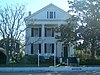 | September 22, 1972 (#72000316) | Southwestern corner of Market Street and Avenue F 29°43′42″N 84°59′08″W / 29.728333°N 84.985556°W / 29.728333; -84.985556 (David G. Raney House) | Apalachicola | |
| 8 | Trinity Episcopal Church | 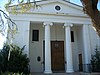 | June 30, 1972 (#72000317) | Avenue D and 6th Street (Gorrie Square) 29°43′30″N 84°59′07″W / 29.725°N 84.985278°W / 29.725; -84.985278 (Trinity Episcopal Church) | Apalachicola | |
| 9 | Yent Mound | Upload image | May 24, 1973 (#73000577) | Address Restricted | St. Teresa |
See also
Wikimedia Commons has media related to National Register of Historic Places in Franklin County, Florida.
- List of National Historic Landmarks in Florida
- National Register of Historic Places listings in Florida
References
- ^ The latitude and longitude information provided in this table was derived originally from the National Register Information System, which has been found to be fairly accurate for about 99% of listings. Some locations in this table may have been corrected to current GPS standards.
- ^ National Park Service, United States Department of the Interior, "National Register of Historic Places: Weekly List Actions", retrieved April 26, 2024.
- ^ Numbers represent an alphabetical ordering by significant words. Various colorings, defined here, differentiate National Historic Landmarks and historic districts from other NRHP buildings, structures, sites or objects.
- ^ "National Register Information System". National Register of Historic Places. National Park Service. March 13, 2009.
- ^ The eight-digit number below each date is the number assigned to each location in the National Register Information System database, which can be viewed by clicking the number.
- v
- t
- e
by county
- Alachua
- Baker
- Bay
- Bradford
- Brevard
- Broward
- Calhoun
- Charlotte
- Citrus
- Clay
- Collier
- Columbia
- DeSoto
- Dixie
- Duval
- Escambia
- Flagler
- Franklin
- Gadsden
- Gilchrist
- Glades
- Gulf
- Hamilton
- Hardee
- Hendry
- Hernando
- Highlands
- Hillsborough
- Holmes
- Indian River
- Jackson
- Jefferson
- Lake
- Lee
- Leon
- Levy
- Liberty
- Madison
- Manatee
- Marion
- Martin
- Miami-Dade
- Monroe
- Nassau
- Okaloosa
- Okeechobee
- Orange
- Osceola
- Palm Beach
- Pasco
- Pinellas
- Polk
- Putnam
- Santa Rosa
- Sarasota
- Seminole
- St. Johns
- St. Lucie
- Sumter
- Suwannee
- Taylor
- Union
- Volusia
- Wakulla
- Walton
- Washington

Municipalities and communities of Franklin County, Florida, United States | ||
|---|---|---|
County seat: Apalachicola | ||
| Cities |  | |
| CDPs |
| |
| Unincorporated communities |
| |
| Tourist attractions | ||
| Archaeological site | ||
| ||


