National Register of Historic Places listings in Wakulla County, Florida

This is a list of the National Register of Historic Places listings in Wakulla County, Florida.
This is intended to be a complete list of the properties and districts on the National Register of Historic Places in Wakulla County, Florida, United States. The locations of National Register properties and districts for which the latitude and longitude coordinates are included below, may be seen in a map.[1]
There are 11 properties and districts listed on the National Register in the county, including 1 National Historic Landmark.
This National Park Service list is complete through NPS recent listings posted April 26, 2024.[2]
Map all coordinates using OpenStreetMap
Download coordinates as:
- KML
- GPX (all coordinates)
- GPX (primary coordinates)
- GPX (secondary coordinates)
| Alachua - Baker - Bay - Bradford - Brevard - Broward - Calhoun - Charlotte - Citrus - Clay - Collier - Columbia - DeSoto - Dixie - Duval - Escambia - Flagler - Franklin - Gadsden - Gilchrist - Glades - Gulf - Hamilton - Hardee - Hendry - Hernando - Highlands - Hillsborough (Tampa) - Holmes - Indian River - Jackson - Jefferson - Lafayette - Lake - Lee - Leon - Levy - Liberty - Madison - Manatee - Marion - Martin - Miami-Dade (Miami) - Monroe - Nassau - Okaloosa - Okeechobee - Orange - Osceola - Palm Beach - Pasco - Pinellas - Polk - Putnam - St. Johns - St. Lucie - Santa Rosa - Sarasota - Seminole - Sumter - Suwannee - Taylor - Union - Volusia - Wakulla - Walton - Washington |
Current listings
| [3] | Name on the Register[4] | Image | Date listed[5] | Location | City or town | Description |
|---|---|---|---|---|---|---|
| 1 | Bird Hammock | Upload image | December 15, 1972 (#72000357) | Address Restricted | Wakulla Beach | |
| 2 | Bo Lynn's Grocery |  | February 14, 2017 (#100000643) | 850 Port Leon Dr. 30°09′19″N 84°12′13″W / 30.155163°N 84.203715°W / 30.155163; -84.203715 (Bo Lynn's Grocery) | St. Marks | |
| 3 | Mount Beasor Primitive Baptist Church |  | October 17, 2012 (#12000866) | 120 Mount Beasor Rd. 30°05′31″N 84°30′57″W / 30.091823°N 84.515830°W / 30.091823; -84.515830 (Mount Beasor Primitive Baptist Church) | Sopchoppy vicinity | |
| 4 | Fort San Marcos de Apalache |  | November 13, 1966 (#66000271) | 18 miles south of Tallahassee 30°09′18″N 84°12′40″W / 30.155°N 84.211111°W / 30.155; -84.211111 (Fort San Marcos de Apalache) | St. Marks | |
| 5 | Old Sopchoppy High School Gymnasium | 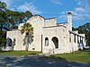 | June 1, 1990 (#90000849) | Junction of Second Avenue and Summer Street 30°03′29″N 84°29′34″W / 30.058056°N 84.492778°W / 30.058056; -84.492778 (Old Sopchoppy High School Gymnasium) | Sopchoppy | |
| 6 | Old Wakulla County Courthouse |  | May 3, 1976 (#76000607) | Church Street 30°10′30″N 84°22′35″W / 30.175°N 84.376389°W / 30.175; -84.376389 (Old Wakulla County Courthouse) | Crawfordville | |
| 7 | Panacea Mineral Springs | 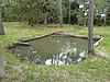 | November 10, 2022 (#100008423) | 1505 Coastal Hwy 30°02′04″N 84°23′23″W / 30.034462°N 84.389615°W / 30.034462; -84.389615 (Panacea Mineral Springs) | Panacea | |
| 8 | St. Marks Lighthouse |  | July 31, 1972 (#72000356) | Northern side of Apalache Bay at the terminus of State Road 59 30°04′24″N 84°10′45″W / 30.073333°N 84.179167°W / 30.073333; -84.179167 (St. Marks Lighthouse) | St. Marks National Wildlife Refuge | |
| 9 | Sopchoppy Depot |  | October 12, 2017 (#100001738) | 34 Rose St. 30°03′40″N 84°29′28″W / 30.061193°N 84.491025°W / 30.061193; -84.491025 (Sopchoppy Depot) | Sopchoppy | |
| 10 | Sopchoppy School |  | October 12, 2001 (#01001088) | 164 Yellow Jacket Avenue 30°03′28″N 84°29′42″W / 30.057778°N 84.495°W / 30.057778; -84.495 (Sopchoppy School) | Sopchoppy | |
| 11 | Wakulla Springs Archeological and Historic District | 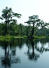 | January 25, 1993 (#92001760) | 1 Spring Drive 30°13′58″N 84°17′32″W / 30.232778°N 84.292222°W / 30.232778; -84.292222 (Wakulla Springs Archeological and Historic District) | Wakulla Springs |
See also
Wikimedia Commons has media related to National Register of Historic Places in Wakulla County, Florida.
- List of National Historic Landmarks in Florida
- National Register of Historic Places listings in Florida
References
- ^ The latitude and longitude information provided in this table was derived originally from the National Register Information System, which has been found to be fairly accurate for about 99% of listings. Some locations in this table may have been corrected to current GPS standards.
- ^ National Park Service, United States Department of the Interior, "National Register of Historic Places: Weekly List Actions", retrieved April 26, 2024.
- ^ Numbers represent an alphabetical ordering by significant words. Various colorings, defined here, differentiate National Historic Landmarks and historic districts from other NRHP buildings, structures, sites or objects.
- ^ "National Register Information System". National Register of Historic Places. National Park Service. March 13, 2009.
- ^ The eight-digit number below each date is the number assigned to each location in the National Register Information System database, which can be viewed by clicking the number.
- v
- t
- e
by county
- Alachua
- Baker
- Bay
- Bradford
- Brevard
- Broward
- Calhoun
- Charlotte
- Citrus
- Clay
- Collier
- Columbia
- DeSoto
- Dixie
- Duval
- Escambia
- Flagler
- Franklin
- Gadsden
- Gilchrist
- Glades
- Gulf
- Hamilton
- Hardee
- Hendry
- Hernando
- Highlands
- Hillsborough
- Holmes
- Indian River
- Jackson
- Jefferson
- Lake
- Lee
- Leon
- Levy
- Liberty
- Madison
- Manatee
- Marion
- Martin
- Miami-Dade
- Monroe
- Nassau
- Okaloosa
- Okeechobee
- Orange
- Osceola
- Palm Beach
- Pasco
- Pinellas
- Polk
- Putnam
- Santa Rosa
- Sarasota
- Seminole
- St. Johns
- St. Lucie
- Sumter
- Suwannee
- Taylor
- Union
- Volusia
- Wakulla
- Walton
- Washington

Municipalities and communities of Wakulla County, Florida, United States | ||
|---|---|---|
County seat: Crawfordville | ||
| Cities |  | |
| CDPs | ||
| Unincorporated communities | ||
| Ghost towns | ||
| ||


