National Register of Historic Places listings in Pinellas County, Florida

This is a list of the National Register of Historic Places listings in Pinellas County, Florida.
This is intended to be a complete list of the properties and districts on the National Register of Historic Places in Pinellas County, Florida, United States. The locations of National Register properties and districts for which the latitude and longitude coordinates are included below, may be seen in a map.[1]
There are 76 properties and districts listed on the National Register in the county, including 1 National Historic Landmark. Another 3 properties were once listed but have been removed.
This National Park Service list is complete through NPS recent listings posted April 26, 2024.[2]
Map all coordinates using OpenStreetMap
Download coordinates as:
- KML
- GPX (all coordinates)
- GPX (primary coordinates)
- GPX (secondary coordinates)
| Alachua - Baker - Bay - Bradford - Brevard - Broward - Calhoun - Charlotte - Citrus - Clay - Collier - Columbia - DeSoto - Dixie - Duval - Escambia - Flagler - Franklin - Gadsden - Gilchrist - Glades - Gulf - Hamilton - Hardee - Hendry - Hernando - Highlands - Hillsborough (Tampa) - Holmes - Indian River - Jackson - Jefferson - Lafayette - Lake - Lee - Leon - Levy - Liberty - Madison - Manatee - Marion - Martin - Miami-Dade (Miami) - Monroe - Nassau - Okaloosa - Okeechobee - Orange - Osceola - Palm Beach - Pasco - Pinellas - Polk - Putnam - St. Johns - St. Lucie - Santa Rosa - Sarasota - Seminole - Sumter - Suwannee - Taylor - Union - Volusia - Wakulla - Walton - Washington |
Current listings
| [3] | Name on the Register[4] | Image | Date listed[5] | Location | City or town | Description |
|---|---|---|---|---|---|---|
| 1 | Alexander Hotel |  | November 1, 1984 (#84000200) | 535 Central Avenue 27°46′16″N 82°38′28″W / 27.7711°N 82.6411°W / 27.7711; -82.6411 (Alexander Hotel) | St. Petersburg | |
| 2 | Abercrombie Site Complex | 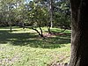 | October 11, 2019 (#100004520) | Address Restricted | St. Petersburg | |
| 3 | Anclote Key Lighthouse |  | April 1, 1999 (#99000410) | Southern end of Anclote Key Island 28°10′00″N 82°50′42″W / 28.1667°N 82.845°W / 28.1667; -82.845 (Anclote Key Lighthouse) | Anclote Key Island | |
| 4 | Andrews Memorial Chapel |  | July 31, 1972 (#72000346) | Buena Vista and San Mateo 28°02′03″N 82°47′03″W / 28.0343°N 82.7843°W / 28.0343; -82.7843 (Andrews Memorial Chapel) | Dunedin | |
| 5 | Arcade Hotel |  | January 12, 1984 (#84000943) | 210 Pinellas Avenue 28°08′40″N 82°45′24″W / 28.1444°N 82.7567°W / 28.1444; -82.7567 (Arcade Hotel) | Tarpon Springs | |
| 6 | N. G. Arfaras Sponge Packing House |  | April 10, 1991 (#91000412) | 26 West Park Street 28°09′00″N 82°45′26″W / 28.15°N 82.7572°W / 28.15; -82.7572 (N. G. Arfaras Sponge Packing House) | Tarpon Springs | |
| 7 | Bay Pines Site (8Pi64) | 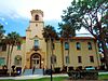 | February 23, 1983 (#83001443) | Address Restricted | Bay Pines | |
| 8 | Bay Pines Veterans Administration Home and Hospital Historic District |  | June 27, 2012 (#12000363) | 10000 Bay Pines Blvd. 27°48′49″N 82°46′41″W / 27.8136°N 82.7781°W / 27.8136; -82.7781 (Bay Pines Veterans Administration Home and Hospital Historic District) | Bay Pines | United States Second Generation Veterans Hospitals MPS |
| 9 | Willis S. Blatchley House |  | September 23, 2009 (#09000747) | 232 Lee Street 28°01′11″N 82°47′24″W / 28.0198°N 82.7900°W / 28.0198; -82.7900 (Willis S. Blatchley House) | Dunedin | |
| 10 | Boone House |  | July 3, 1986 (#86001457) | 601 Fifth Avenue North 27°46′38″N 82°38′31″W / 27.7772°N 82.6419°W / 27.7772; -82.6419 (Boone House) | St. Petersburg | |
| 11 | Casa Coe da Sol |  | July 17, 1980 (#80000963) | 510 Park Street 27°46′39″N 82°44′46″W / 27.7775°N 82.7461°W / 27.7775; -82.7461 (Casa Coe da Sol) | St. Petersburg | |
| 12 | Casa De Muchas Flores |  | January 31, 1985 (#85000160) | 1446 Park Street North 27°47′11″N 82°45′09″W / 27.7864°N 82.7525°W / 27.7864; -82.7525 (Casa De Muchas Flores) | St. Petersburg | |
| 13 | Central High School |  | August 1, 1984 (#84000946) | 2501-5th Avenue North 27°46′40″N 82°40′06″W / 27.7778°N 82.6683°W / 27.7778; -82.6683 (Central High School) | St. Petersburg | Now part of St. Petersburg High School |
| 14 | Civitan Beach House | Upload image | April 8, 2021 (#100006377) | 18602-18604 Gulf Blvd. 27°50′21″N 82°50′20″W / 27.8391°N 82.8388°W / 27.8391; -82.8388 (Civitan Beach House) | Indian Shores | |
| 15 | Cleveland Street Post Office |  | August 7, 1980 (#80000962) | 650 Cleveland Street 27°57′56″N 82°47′50″W / 27.9656°N 82.7972°W / 27.9656; -82.7972 (Cleveland Street Post Office) | Clearwater | |
| 16 | Cycadia Cemetery |  | March 20, 2019 (#100003522) | 1105 E. Tarpon Ave. 28°08′47″N 82°44′21″W / 28.1465°N 82.7391°W / 28.1465; -82.7391 (Cycadia Cemetery) | Tarpon Springs | |
| 17 | Dennis Hotel | 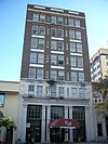 | April 17, 1986 (#86000804) | 326 First Avenue North 27°46′12″N 82°37′33″W / 27.77°N 82.6258°W / 27.77; -82.6258 (Dennis Hotel) | St. Petersburg | |
| 18 | Domestic Science and Manual Training School |  | October 14, 1999 (#99001250) | 440–442 Second Avenue North 27°46′22″N 82°38′22″W / 27.7728°N 82.6394°W / 27.7728; -82.6394 (Domestic Science and Manual Training School) | St. Petersburg | |
| 19 | Don Ce Sar Hotel |  | April 3, 1975 (#75000563) | 3400 Gulf Boulevard 27°42′32″N 82°44′15″W / 27.7089°N 82.7375°W / 27.7089; -82.7375 (Don Ce Sar Hotel) | St. Pete Beach | |
| 20 | J. O. Douglas House |  | November 29, 1979 (#79000691) | 209 Scotland Street 28°00′38″N 82°47′29″W / 28.0106°N 82.7914°W / 28.0106; -82.7914 (J. O. Douglas House) | Dunedin | |
| 21 | Downtown St. Petersburg Historic District |  | April 30, 2004 (#04000364) | Bounded by 5th Avenue North, Beach Drive Northeast, Central Avenue, and 9th Street North 27°46′34″N 82°38′19″W / 27.7761°N 82.6386°W / 27.7761; -82.6386 (Downtown St. Petersburg Historic District) | St. Petersburg | |
| 22 | Duchess (Sponge Hooking Boat) | 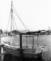 | August 2, 1990 (#90001133) | Tarpon Springs Sponge Docks at Dodecanese Boulevard 28°09′19″N 82°45′43″W / 28.1553°N 82.7619°W / 28.1553; -82.7619 (Duchess (Sponge Hooking Boat)) | Tarpon Springs | Part of the Tarpon Springs Sponge Boats MPS |
| 23 | Dunedin Isles Golf Club Golf Course |  | June 4, 2014 (#14000283) | 1050 Palm Blvd. 28°02′30″N 82°46′36″W / 28.04170°N 82.7768°W / 28.04170; -82.7768 (Dunedin Isles Golf Club Golf Course) | Dunedin | |
| 24 | First Methodist Church of St. Petersburg |  | September 13, 1990 (#90001433) | 212 Third Street, North 27°46′31″N 82°38′15″W / 27.7753°N 82.6375°W / 27.7753; -82.6375 (First Methodist Church of St. Petersburg) | St. Petersburg | |
| 25 | Fort Desoto Batteries |  | December 2, 1977 (#77000407) | 8 miles (13 km) south of St. Petersburg on Mullet Key 27°36′53″N 82°44′13″W / 27.6147°N 82.7369°W / 27.6147; -82.7369 (Fort Desoto Batteries) | St. Petersburg | |
| 26 | George N. Cretekos (Sponge Diving Boat) | 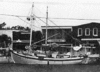 | August 3, 1990 (#90001135) | Tarpon Springs Sponge Docks at Dodecanese Boulevard 28°09′19″N 82°45′43″W / 28.1553°N 82.7619°W / 28.1553; -82.7619 (George N. Cretekos (Sponge Diving Boat)) | Tarpon Springs | Part of the Tarpon Springs Sponge Boats MPS |
| 27 | Green-Richman Arcade | 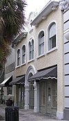 | January 30, 1998 (#98000027) | 689 Central Avenue 27°46′17″N 82°38′37″W / 27.7714°N 82.6436°W / 27.7714; -82.6436 (Green-Richman Arcade) | St. Petersburg | |
| 28 | Gulfport Casino |  | August 8, 2014 (#14000477) | 5500 Shore Blvd. 27°44′15″N 82°42′28″W / 27.7376°N 82.7078°W / 27.7376; -82.7078 (Gulfport Casino) | Gulfport | |
| 29 | Harbor Oaks Residential District | 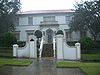 | March 15, 1988 (#87002133) | Roughly bounded by Druid Road, South Fort Harrison Avenue, Lotus Path, & Clearwater Harbor 27°57′21″N 82°48′11″W / 27.9558°N 82.8031°W / 27.9558; -82.8031 (Harbor Oaks Residential District) | Clearwater | |
| 30 | James Henry House |  | April 16, 2013 (#13000164) | 950 12th St., N. 27°46′54″N 82°39′04″W / 27.7818°N 82.6511°W / 27.7818; -82.6511 (James Henry House) | St. Petersburg | |
| 31 | House at 827 Mandalay Avenue | Upload image | February 2, 2021 (#100006118) | 827 Mandalay Ave. 27°59′41″N 82°49′37″W / 27.9947°N 82.8269°W / 27.9947; -82.8269 (House at 827 Mandalay Avenue) | Clearwater | |
| 32 | Huggins-Stengel Field |  | August 27, 2019 (#100004348) | 1320 5th St. North 27°47′09″N 82°38′24″W / 27.7858°N 82.6401°W / 27.7858; -82.6401 (Huggins-Stengel Field) | St. Petersburg | |
| 33 | Ingleside | 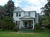 | April 28, 1992 (#92000405) | 333 South Bayshore Boulevard 27°59′18″N 82°41′25″W / 27.9883°N 82.6903°W / 27.9883; -82.6903 (Ingleside) | Safety Harbor | |
| 34 | Louis Johnson Building | 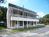 | December 3, 1987 (#87001632) | 161 First Street, Southwest 27°54′55″N 82°47′19″W / 27.9153°N 82.7886°W / 27.9153; -82.7886 (Louis Johnson Building) | Largo | |
| 35 | Jungle Prada Site | 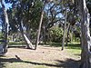 | February 4, 2003 (#03000007) | Address Restricted 27°47′19″N 82°45′08″W / 27.7886°N 82.7522°W / 27.7886; -82.7522 (Jungle Prada Site) | St. Petersburg | |
| 36 | Kenwood Historic District | 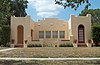 | August 4, 2003 (#03000729) | Roughly bounded by 9th Avenue, 19th Street, 1st Avenue, 31st Street, 5th Ave, and 34th Street 27°40′40″N 82°41′08″W / 27.6778°N 82.6856°W / 27.6778; -82.6856 (Kenwood Historic District) | St. Petersburg | |
| 37 | S. H. Kress and Company Building |  | October 1, 2001 (#01001057) | 475 Central Avenue 27°46′15″N 82°38′25″W / 27.7708°N 82.6403°W / 27.7708; -82.6403 (S. H. Kress and Company Building) | St. Petersburg | |
| 38 | Maximo Beach Site |  | October 11, 2019 (#100004521) | Address Restricted | St. Petersburg | |
| 39 | John & Florence McKeage House |  | April 9, 2013 (#13000145) | 209 Park St., S. 27°46′08″N 82°44′29″W / 27.7689°N 82.7415°W / 27.7689; -82.7415 (John & Florence McKeage House) | St. Petersburg | |
| 40 | E. R. Meres Sponge Packing House |  | April 10, 1991 (#91000411) | 106 Read Street 28°08′57″N 82°45′42″W / 28.1492°N 82.7617°W / 28.1492; -82.7617 (E. R. Meres Sponge Packing House) | Tarpon Springs | |
| 41 | Mount Olive African Methodist Episcopal Church | 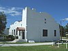 | February 3, 2000 (#99000802) | 600 Jones Street 27°58′08″N 82°47′54″W / 27.9689°N 82.7983°W / 27.9689; -82.7983 (Mount Olive African Methodist Episcopal Church) | Clearwater | |
| 42 | N. K. Symi (Sponge Diving Boat) | 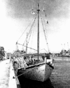 | August 2, 1990 (#90001132) | Tarpon Springs Sponge Docks at Dodecanese Boulevard 28°09′19″N 82°45′43″W / 28.1553°N 82.7619°W / 28.1553; -82.7619 (N. K. Symi (Sponge Diving Boat)) | Tarpon Springs | Part of the Tarpon Springs Sponge Boats MPS |
| 43 | North Shore Historic District |  | February 20, 2003 (#03000040) | Bounded by 4th Street, 5th Avenue, Tampa Bay, and 30th Ave 27°47′17″N 82°37′58″W / 27.788056°N 82.632778°W / 27.788056; -82.632778 (North Shore Historic District) | St. Petersburg | |
| 44 | North Ward School | Upload image | September 29, 2021 (#100007057) | 900 North Fort Harrison Ave. 27°58′30″N 82°47′56″W / 27.9750°N 82.7990°W / 27.9750; -82.7990 (North Ward School) | Clearwater | |
| 45 | Old Belleair Town Hall | 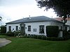 | May 6, 1994 (#94000421) | 903 Ponce de Leon Boulevard 27°56′05″N 82°48′14″W / 27.934722°N 82.803889°W / 27.934722; -82.803889 (Old Belleair Town Hall) | Belleair | |
| 46 | Old Pinellas County Courthouse |  | June 25, 1992 (#92000828) | 315 Court Street 27°57′43″N 82°48′05″W / 27.961944°N 82.801389°W / 27.961944; -82.801389 (Old Pinellas County Courthouse) | Clearwater | |
| 47 | Old Tarpon Springs City Hall |  | August 10, 1990 (#90001117) | 101 South Pinellas Avenue 28°08′42″N 82°45′24″W / 28.145°N 82.756667°W / 28.145; -82.756667 (Old Tarpon Springs City Hall) | Tarpon Springs | |
| 48 | Old Tarpon Springs High School |  | October 11, 1990 (#90001538) | 324 East Pine Street 28°09′02″N 82°45′06″W / 28.150556°N 82.751667°W / 28.150556; -82.751667 (Old Tarpon Springs High School) | Tarpon Springs | |
| 49 | Pass-a-Grille Historic District |  | October 19, 1989 (#89001734) | Roughly bounded by 12th Avenue, Gulf Boulevard, 4th Avenue, and Gulf Avenue 27°41′17″N 82°44′14″W / 27.688056°N 82.737222°W / 27.688056; -82.737222 (Pass-a-Grille Historic District) | St. Pete Beach | There was a boundary increase on September 15, 2003 (refnum 03000943) |
| 50 | Peninsular Fruit Company Building | Upload image | April 26, 2023 (#100008871) | 10000 Gandy Blvd. North 27°51′50″N 82°38′16″W / 27.863763°N 82.637679°W / 27.863763; -82.637679 (Peninsular Fruit Company Building) | St. Petersburg | |
| 51 | Potter House |  | June 13, 1986 (#86001258) | 577 Second Street South 27°45′51″N 82°38′09″W / 27.764167°N 82.635833°W / 27.764167; -82.635833 (Potter House) | St. Petersburg | Demolished by 1990[6] |
| 52 | Princess Mound Site |  | October 10, 2019 (#100004522) | Address Restricted | St. Petersburg vicinity | |
| 53 | Donald Roebling Estate |  | December 19, 1979 (#79000689) | 700 Orange Avenue 27°57′27″N 82°48′17″W / 27.9575°N 82.804722°W / 27.9575; -82.804722 (Donald Roebling Estate) | Clearwater | |
| 54 | Rose Hill Cemetery |  | March 7, 2017 (#100000711) | 0 Jasmine Avenue 28°08′55″N 82°44′06″W / 28.148545°N 82.735042°W / 28.148545; -82.735042 (Rose Hill Cemetery) | Tarpon Springs | |
| 55 | Roser Park Historic District | 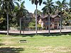 | April 1, 1998 (#98000295) | Roughly bounded by 5th and 9th Streets South and 6th and 11th Avenues South 27°45′35″N 82°38′31″W / 27.759722°N 82.641944°W / 27.759722; -82.641944 (Roser Park Historic District) | St. Petersburg | |
| 56 | Maurice and Thelma Rothman House |  | February 27, 2013 (#13000034) | 1018 Park St., N. 27°46′54″N 82°44′57″W / 27.781588°N 82.749122°W / 27.781588; -82.749122 (Maurice and Thelma Rothman House) | St. Petersburg | |
| 57 | Round Lake Historic District |  | September 29, 2003 (#03000824) | Roughly 5th Avenue, 9th Street, 13th Avenue, and 4th Street 27°46′51″N 82°38′28″W / 27.780810°N 82.641185°W / 27.780810; -82.641185 (Round Lake Historic District) | St. Petersburg | |
| 58 | Safety Harbor site |  | October 15, 1966 (#66000270) | Address Restricted 28°00′27″N 82°40′48″W / 28.0075°N 82.68°W / 28.0075; -82.68 (Safety Harbor site) | Safety Harbor | |
| 59 | Safford House |  | October 16, 1974 (#74000654) | Parken Place 28°08′53″N 82°45′36″W / 28.148056°N 82.76°W / 28.148056; -82.76 (Safford House) | Tarpon Springs | |
| 60 | St. Nicholas III (Sponge Diving Boat) |  | August 3, 1990 (#90001136) | Tarpon Springs Sponge Docks at Dodecanese Boulevard 28°09′19″N 82°45′43″W / 28.155278°N 82.761944°W / 28.155278; -82.761944 (St. Nicholas III (Sponge Diving Boat)) | Tarpon Springs | Part of the Tarpon Springs Sponge Boats MPS |
| 61 | St. Nicholas VI (Sponge Diving Boat) |  | August 3, 1990 (#90001134) | Tarpon Springs Sponge Docks at Dodecanese Boulevard 28°09′19″N 82°45′43″W / 28.155278°N 82.761944°W / 28.155278; -82.761944 (St. Nicholas VI (Sponge Diving Boat)) | Tarpon Springs | Part of the Tarpon Springs Sponge Boats MPS |
| 62 | St. Petersburg Lawn Bowling Club |  | July 9, 1980 (#80004602) | 536 4th Avenue, North 27°46′33″N 82°38′27″W / 27.775833°N 82.640833°W / 27.775833; -82.640833 (St. Petersburg Lawn Bowling Club) | St. Petersburg | |
| 63 | St. Petersburg Public Library | 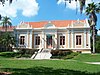 | June 13, 1986 (#86001259) | 280 Fifth Street North 27°46′29″N 82°38′26″W / 27.774722°N 82.640556°W / 27.774722; -82.640556 (St. Petersburg Public Library) | St. Petersburg | |
| 64 | St. Petersburg Woman's Club |  | July 15, 1994 (#94000708) | 40 Snell Isle Boulevard 27°47′34″N 82°38′10″W / 27.792778°N 82.636111°W / 27.792778; -82.636111 (St. Petersburg Woman's Club) | St. Petersburg | |
| 65 | Sanitary Public Market |  | June 27, 2002 (#02000680) | 1825 4th Street North 27°47′24″N 82°38′18″W / 27.79°N 82.638333°W / 27.79; -82.638333 (Sanitary Public Market) | St. Petersburg | |
| 66 | Snell Arcade |  | November 4, 1982 (#82001037) | 405 Central Avenue 27°46′16″N 82°38′20″W / 27.771111°N 82.638889°W / 27.771111; -82.638889 (Snell Arcade) | St. Petersburg | |
| 67 | South Ward School |  | June 18, 1979 (#79000690) | 610 South Fort Harrison Avenue 27°57′29″N 82°48′02″W / 27.958056°N 82.800556°W / 27.958056; -82.800556 (South Ward School) | Clearwater | |
| 68 | Studebaker Building | 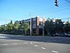 | July 5, 1985 (#85001485) | 600 Fourth Street South 27°45′49″N 82°38′18″W / 27.763611°N 82.638333°W / 27.763611; -82.638333 (Studebaker Building) | St. Petersburg | |
| 69 | Sunset Hotel |  | November 24, 2014 (#14000952) | 7401 Central Ave. 27°46′17″N 82°44′28″W / 27.771305°N 82.741007°W / 27.771305; -82.741007 (Sunset Hotel) | St. Petersburg | |
| 70 | Tarpon Springs Greektown Historic District |  | June 2, 2014 (#14000321) | Bounded by Dodecanese & Roosevelt Blvds., W. Tarpon & N. Pinellas Aves. 28°09′08″N 82°45′36″W / 28.1521461°N 82.7600243°W / 28.1521461; -82.7600243 (Tarpon Springs Greektown Historic District) | Tarpon Springs | |
| 71 | Tarpon Springs Historic District | 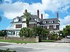 | December 6, 1990 (#90001762) | Roughly bounded by Read Street, Hibiscus Street, Orange Street, Levis Avenue, Lemon Street, and Spring Bayou 28°09′04″N 82°47′13″W / 28.151111°N 82.786944°W / 28.151111; -82.786944 (Tarpon Springs Historic District) | Tarpon Springs | |
| 72 | U.S. Post Office |  | April 4, 1975 (#75000564) | Southwestern corner of 1st Avenue North and 4th Street North 27°46′17″N 82°38′21″W / 27.771389°N 82.639167°W / 27.771389; -82.639167 (U.S. Post Office) | St. Petersburg | |
| 73 | Veillard House |  | October 29, 1982 (#82001038) | 262 North 4th Avenue 27°46′34″N 82°38′24″W / 27.776111°N 82.64°W / 27.776111; -82.64 (Veillard House) | St. Petersburg | |
| 74 | Vinoy Park Hotel |  | September 11, 1978 (#78000955) | 501 Fifth Avenue Northeast 27°46′41″N 82°37′44″W / 27.778056°N 82.628889°W / 27.778056; -82.628889 (Vinoy Park Hotel) | St. Petersburg | |
| 75 | Weedon Island Site | 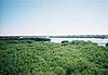 | June 13, 1972 (#72000347) | Address Restricted 27°50′42″N 82°36′07″W / 27.845°N 82.601944°W / 27.845; -82.601944 (Weedon Island Site) | St. Petersburg | |
| 76 | John C. Williams House |  | April 24, 1975 (#75000565) | 444 5th Avenue South 27°45′55″N 82°38′23″W / 27.765278°N 82.639722°W / 27.765278; -82.639722 (John C. Williams House) | St. Petersburg |
Former listings
| [3] | Name on the Register | Image | Date listed | Date removed | Location | City or town | Description |
|---|---|---|---|---|---|---|---|
| 1 | Belleview-Biltmore Hotel |  | December 26, 1979 (#79000687) | October 2, 2017 | Off State Road 697 27°56′37″N 82°49′06″W / 27.943611°N 82.818333°W / 27.943611; -82.818333 (Belleview-Biltmore Hotel) | Clearwater | Mostly torn down. Pieces of the original structure were kept and are being utilized for other purposes. |
| 2 | Louis Ducros House |  | July 2, 1979 (#79000688) | September 2, 2009 | 622 Belleview Boulevard 27°56′41″N 82°47′50″W / 27.9447°N 82.7972°W / 27.9447; -82.7972 (Louis Ducros House) | Clearwater | Relocated from original address at 1324 South Fort Harrison Street.[7] |
| 3 | Tarpon Springs Sponge Exchange | Upload image | July 24, 1972 (#72000348) | October 10, 1984 | Dodecanese St. | Tarpon Springs |
See also
Wikimedia Commons has media related to National Register of Historic Places in Pinellas County, Florida.
- List of National Historic Landmarks in Florida
- National Register of Historic Places listings in Florida
References
- ^ The latitude and longitude information provided in this table was derived originally from the National Register Information System, which has been found to be fairly accurate for about 99% of listings. Some locations in this table may have been corrected to current GPS standards.
- ^ National Park Service, United States Department of the Interior, "National Register of Historic Places: Weekly List Actions", retrieved April 26, 2024.
- ^ a b Numbers represent an alphabetical ordering by significant words. Various colorings, defined here, differentiate National Historic Landmarks and historic districts from other NRHP buildings, structures, sites or objects.
- ^ "National Register Information System". National Register of Historic Places. National Park Service. March 13, 2009.
- ^ The eight-digit number below each date is the number assigned to each location in the National Register Information System database, which can be viewed by clicking the number.
- ^ An Active Harbor for a Growing City (1920-1939), University of South Florida St. Petersburg
- ^ New life for historic pink house in Clearwater Archived 2009-01-07 at the Wayback Machine, Eileen Schulte, November 16, 2008
- v
- t
- e
by county
- Alachua
- Baker
- Bay
- Bradford
- Brevard
- Broward
- Calhoun
- Charlotte
- Citrus
- Clay
- Collier
- Columbia
- DeSoto
- Dixie
- Duval
- Escambia
- Flagler
- Franklin
- Gadsden
- Gilchrist
- Glades
- Gulf
- Hamilton
- Hardee
- Hendry
- Hernando
- Highlands
- Hillsborough
- Holmes
- Indian River
- Jackson
- Jefferson
- Lake
- Lee
- Leon
- Levy
- Liberty
- Madison
- Manatee
- Marion
- Martin
- Miami-Dade
- Monroe
- Nassau
- Okaloosa
- Okeechobee
- Orange
- Osceola
- Palm Beach
- Pasco
- Pinellas
- Polk
- Putnam
- Santa Rosa
- Sarasota
- Seminole
- St. Johns
- St. Lucie
- Sumter
- Suwannee
- Taylor
- Union
- Volusia
- Wakulla
- Walton
- Washington


